|
1. Overview
|
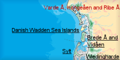
Name: |
The marshland at Varde Å, Kongeåen and Ribe Å |
|
Delimitation: |
|
|
Size: |
|
|
Location
- map: |
|
|
Origin of name: |
|
|
Relationship/similarities with other cultural entities: |
Borders the southern entity on the mainland. |
|
Characteristic elements and
ensembles: |
The glacial hills (oldest quaternary Danish landscapes) and sandy
outwash plains, together named “Geest”. Different stages of marshlands
represent the youngest quaternary landscapes of Denmark and also
unique elements in the international Wadden Sea context (peninsula of
Skallingen; largest natural salt marshes and
Varde Stream Estuary only
non-embanked estuary).
In NW the huge dune landscape with plantations and today thousands of
summer cottages and a military exercise ground.
Many settlements from prehistoric times (around Esbjerg). From
medieval time the town of Ribe (oldest town of Scandinavia) and the
newest “city” Esbjerg. Fine examples of best preserved villages of
Denmark. More industries and larger urban settlements than in the
other parts of the Danish Wadden Sea Region. |

2. Geology and geography
2.1 General
The main geological elements of the area are:
|
•
|
the glacial hill islands |
|
• |
the out-washed plains
|
Together named “geest”.
|
• |
the marshlands -
stretching like “tongues” in between the geest – and |
|
• |
the dune landscapes in
the west and the peninsula of Skallingen.
|
During the last Ice Age (Weichsel) the ice only covered the eastern part of
Jutland. The moraine formations in the western part have thus been created
during the second-last Ice Age (Saale) and constitute therefore the oldest
quaternary landscapes in Denmark. The melting of the ice cap during the last
Ice Age created large glacial streams, which washed out over the southwest
of Jutland. The low-lying areas of the original moraine formations
experienced erosion and were replaced by the deposited glacial sand
(out-washed plains). The highest-lying parts of these plains were left as
islands (hill islands) and typically consist of moraine clay with sand and
gravel deposit in the surface. The hill islands are often dome-shaped – with
hillsides (cliffs) against the Wadden Sea (Marbæk and
Sjelborg) and against
the marshlands (Ho, Varde Stream Estuary) and between Darum and Gredstedbro).
The difference of height reaches up to 35 metres above sea level.
Among the oldest Danish quaternary landscapes you will also find the
youngest – the sea-created marshlands.
The marshland formation in the Danish part of the Wadden Sea began
approximately 3,000 years ago (south going north). In the embanked
marshlands at Tjæreborg and
Ribe, the depositing of sea clay ended with the
establishment of embankments during the 1900s. In the non-embanked areas
(forelands and salt meadows) the marsh formation is still ongoing.
North of the Ribe-marsken the marshlands are limited in size compared to the
southern part of the Danish Wadden sea mainland and even more distinct to
the marshlands in Germany and the Netherlands.
Varde Stream Estuary holds the best example in the entire international
Wadden Sea Area of a non-embanked river mouth where the marsh processes are
still ongoing, and the peninsula of Skallingen is the largest, natural salt
marshes of the international Wadden Sea area (1,100 ha).
Since the last Ice Age the Wadden Sea Region has undergone changing periods
with upheaval and subsidence. These processes have influenced the course of
the coastline and have together with wind deposits, especially in the
western part, created huge dune landscapes and scattered inland dunes
elsewhere.
A special feature of the area is the formation of the island of Langli in Ho
Bugt which is a visible sight of the influence of storm surges: before the
great storm surge in October 1634 Langli was the former “Skallingen”
(visible dunes to the west and salt marshes to the east). The storm surge,
however, transformed Langli into an island.
2.2 Present landscape
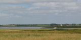
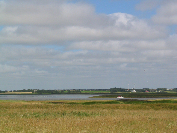
Some of the largest streams in Denmark (named “Å’er”) flow through the area
and into the Wadden Sea: Varde Å is the northernmost and the only
uncontrolled stream. Followed by
Sneum Å,
Kongeåen and
Ribe Å. These streams
and their estuary Varde Å and “valleys” are dominant features of the
landscape – especially in winter term where either seawater or inland
freshwater submerges large parts of the marshlands, as none of these
northern streams are bound by river-dikes.
 |
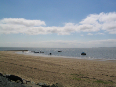
|
View on Varde Å |
Except from the locations where the geest meets the Wadden Sea the
transition zone to the sea is dominated by strips of salt marshes. Apart
from Skallingen the salt marshes east of Esbjerg (Måde Enge) and by
Ribe are
the most dominant.
In general the landscape can be divided into two main characters, pending on
its “open” or “closed” appearance:
|
•
|
south of Esbjerg, where the marshlands are
dominant elements, the landscape is characterized by vast and “nudity”
features, “parcelled out” into large units.
|
|
•
|
north and west of Esbjerg the landscape is in
contrast characterized by a closed appearance (hedges and
plantations), divided into smaller units. Exceptions are Varde Å
Estuary and the island of Langli. |
|
•
|
The west coast the open dune landscape at
Blåvand and the natural marshlands on Skallingen. |
3. Landscape and settlement history
Like any other place in the Wadden Sea Area the infrastructure, reaching
from the ancient trading routes, embankment places and early settlements and
foundation of towns to nowadays placement of road and rail infrastructure,
depends on the level and accessibility of the water (both sea and fresh
water). The area entails fine examples of ribbon development at
Kjelst,
Varde Å Estuary and at Øster Vedsted,
Ribemarsken. Also the oldest and
“newest” towns of Denmark are located within the area by this “guiding
principle”, respectively Ribe (700s) and Esbjerg (1860s). The location of
the town of Varde (1150s) is similar to the location of Ribe: the crossing
of water- and land trading routes.
3.1 Prehistoric and Medieval Times
The earliest settlement in the area originates from the Older Stone Age more
than 8,000 years ago. Temporary hunting and fishing grounds were placed
along the streams whereas the more permanent settlements were located at the
former coastline. Remnants of permanent residences have survived from the
Later Stone Age 6,000 years ago.
Traces of numerous prehistoric settlements and not least the burial mounds
testify to this. In Marbæk Plantage (plantation) there are two protected
Iron Age dwellings where remains of the houses and paving still can be seen.
In the plantation there are also a large protected field systems, called
Celtic fields, from the same time period. In a small heath land area north
of Hjerting there is a group of more than 15 protected burial mounds, out of
a total of 18, which have been discovered. Around Esbjerg a range of
historic dwellings have been excavated, which show the whole development of
settlements from the Stone Age to the Middle Ages.
The inner part of the old moraine land settlements has historically been
hamlets or individual farms. It is quite clear that the occurrence of
marshlands made it possible to establish larger villages, while the lack of
pasture only allowed smaller settlements. However, it seems that the old
moraine land was densely inhabited in prehistoric times.
The combination of cattle farming in the marsh and grain-growing on the
geest can be traced back to the time where the marshland was formed (Bronze
Age). The close concentration of settlements along the geest indicates this.
But also where the hilly islands reach all the way to the coast there have
been many settlements since the beginning of the Iron Age. The history of
many villages can be traced back to the centuries before Christ and many of
these started as single farms in the early Stone Age or Bronze Age. However,
as the villages until the year 1000 were often moved there is no continuity
in the areas – but only within the same natural resource areas – today’s
association of house owners. It was not until the beginning of the medieval
times most villages found a permanent location and the prehistoric villages
are often found in the surrounding areas.
Commerce contacts can be traced both in the material from the prehistoric
tombs and later settlements. Especially the settlement Dankirke (Iron Age)
SW of Ribe has an exceptional position. Here findings and traces from
farmhouses from the 200 BC to 750 AD indicate to have played an important
role in trade with luxury goods with the Roman and Frankish areas and later
contacts with the Frisian and Anglo-Saxon areas.
The majority of the village churches are large churches built in Romanesque
style during 1100-1200s. Often accretions were added to the churches at a
later date. Many of the churches are made of calcareous tuff imported from
the Rhine area and compared to the inland churches they demonstrate the
wealth in the coastal area of the Wadden Sea.
Distinctive findings from the Viking period are known in the entire area –
however, the town of Ribe is unique.
|
Ribe – the oldest town of Scandinavia - was founded as a marked place
at the north bank of Ribe stream in the beginning of 700s and spread
to the south side of the stream in the early Middle Age, where the
present cathedral was established in the period of 11-1200. Throughout
the medieval times Ribe was the “Gateway to Europe”, which apart from
the in-town embankment place, consisted of a number of anchoring
places behind the Wadden Sea Islands. From Ribe there was export of a
variety of foodstuffs fish, grain, and salted meat. From 1400s Ribe
was one of the main export trade centres in Denmark for oxen to the
Dutch market in particular, either driven to the south (Husum or Wedel
west of Hamburg) or shipped directly. The import amongst other things
consisted of cloth and luxury goods from Flanders and Frisia and tuff
stones from the Rhine area - the main building blocks for the churches
in the area. Very early Ribe also became a religious centre and
hometown for the powerful bishop of the diocese and several religious
houses. Not only the impressing cathedral but also the preserved
monastery of Sct. Catharina (1228) represents the visible features of
the past. The monastery was then resident for the Order of the Black
Friars. Also the Grey Friars played a dominant role in Ribe. The royal
power was strongly represented in the town and the kings
Castle of Riberhus was built in high Middle Ages, but abandoned around 1660 and
later demolished. Today only the castle bank with few building remains
is left.
Until the mid 1600s Ribe was one of the most important towns in
Denmark. Hereafter it experienced a fierce recession in the following
centuries. The economic recession was quickened by the frontier
delineation to Germany in 1864, just six kilometres to the south and,
in the same period, by the development of
Esbjerg. From a commercial
point of view Ribe lost a large hinterland. A vain attempt to regain
some of Ribe's former position was done by improving the trade
accessibility to the Wadden Sea by straightening part of Ribe Å in
1855-56.
The financial recession, however, together with the absence of large
fires (since 1580) and the river system is main reasons that Ribe has
maintained its unique potential. Ribe is regarding to its age, history,
the almost unchanged medieval streets and the well-preserved buildings
absolutely unique and an inalienable part of history in the Wadden Sea
Area.
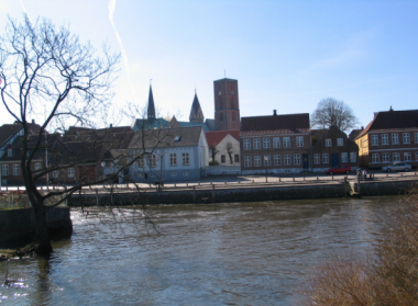 |
 |
| Ribe Skibbroen |
Ribe Kjaergaard |
|
The town of Varde is the other important medieval trade centre within the
entity. Varde was mentioned for the first time in the 1100s and was granted
a municipal charter in 1442. The history and development of the town is
strongly connected with the accessibility to the Wadden Sea, the embankment
places there and the inland trading routes. The structure of the town is
medieval. Varde was devastated by fires in 1779 and 1821, which to a large
extend has contributed to the fact that almost all buildings build before
the 1770s have vanished. Some buildings erected after the fires are, however,
still present in the town.
3.2 Early Modern Times
The outer embankment places by Ribe were the mud flats in the Wadden Sea.
The most important embankment place for Varde was the coastline by
Hjerting,
which evolved into the largest harbour in the Danish part of the Wadden Sea
in the 1700s. Today Hjerting has almost grown together with Esbjerg, but
there are still several well-preserved houses and roads, which can be traced
back to the sea trade.
 |
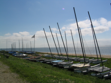 |
| Impressions from Hjerting |
|
Structural changes
During 1750-1850 a country the land reform movement was carried out in
Denmark, in order to improve the agriculture and a general development of
the rural areas. A central element was “The “Enclosure”, which aimed to
merge all plots of each farm in a village.
The enclosure in the Wadden Sea Region mainly took place in the period from
1762–1800. As in the rest of the country the enclosure also left its mark on
the landscape, but not in the same degree as in many other places in Denmark.
Because of the many types of soil: salt marsh, meadow, grain fields, heath
and moor, it was not possible to gather the land of the individual farms.
Therefore the farms – in most cases – remained where it was, with the same
distance to the many plots as before.
In the marshlands the enclosure lefts its mark in form of the characteristic
field structure with long, narrow pastures divided by ditches e.g. at
Vilslev, where the enclosure already took place in 1762. Especially in the
northern part of the area the land was sold from the smaller manors at the
end of the 1700s. In this way new farms were parcelled out at in some places
small holding colonies were founded. An example of this is the manor of
Krogsgård (by Tjæreborg) in 1792, which was parcelled out into small
holdings at Krogsgård Mark. The well preserved structures are today visible
as a fine unity.
In many parts of the region there was one manor per parish. Most of them
were small and over the years the main buildings disappeared. This is true
of, for example, the manors of Sneumgård, Krogsgård and Visselbjerg, where
it cannot immediately be seen that around 1700 these were the cores of
medium sized estates. At the manor Hesselmed by Oksbøl you can still see
what the main building of a small SW-Jutland manor looked like in the 1700s.
3.3 Modern Times
Agriculture and forestry
Embankments of the marshlands in this part of the Wadden Sea all origin from
the 1900s and a gradually change of the utilization of these fenlands became
apparent especially after World War II. The undeveloped and treeless
features are main characteristic of the fenlands within this entity. This is
a distinct difference to almost all other fenlands in the Wadden Sea.
Moreover the features clearly demarcate the marshes from the geest.
The Esbjerg hill island is characterised by the cultivation of the moor,
which took place from the middle of 1800s and with its many fields and
plantations represent a relatively young cultural landscape. In order to
stop the sand drift west of Ho Bugt, large plantations were created. The
first plantations here origin from the middle of 1800s is among the first
plantations in Denmark.
In contrast to the full time farming in the marshland, the original
occupation in these sandy areas was dune farming combined with fishing,
commerce and shipping. The farming was based on livestock – mainly sheep but
also cattle, which gradually could use the lush salt marshes on Skallingen.
Settlement development
In the 1920s and 1950s there were some parcelling out in the area but
smallholder farms have never been a dominant feature.
In most parts of Denmark older farmhouses are half-timbered houses.
Stone-built houses, however, dominate in the Wadden Sea area. This is partly
due to lack of wood, and inspiration from the south. The stone-built houses
became common in the rural area from 1750 and onwards.
There are only few well-preserved farm buildings from the time before the
stone-built houses gained ground.
In the outskirts of the medieval town centres of Ribe and Varde, residential
neighbourhoods arose from the beginning of 1900 and later also in the
smaller towns.
Industry and energy
In the middle of the 1800s steamships were introduced and gave raise to
discussions about the location of a new large steamship harbour. After 1864
where the boarder between Germany and Denmark was almost identical to
southern border of this entity, it was in 1868 decided to establish a
harbour at Esbjerg with rail connection to the rest of the country; mainly
for export and import from England. The harbour did also benefit from the
growth within the Danish animal food production – primary in connection with
the new established co-operative dairies and the increase in international
trade. Moreover fishermen moved from the surrounding coastal areas to the
“city” and thereby created basis for a fishery harbour.
As a consequence of the decision to build a harbour here Esbjerg grew from a
couple of farms to be the fifth largest city in Denmark today (80,000
inhabitants). The strong growth resulted in the elaboration of a city plan
with a right-angled system of streets, which is unique in Danish city
planning.
Esbjerg became the centre of industry in the Wadden Sea region with main
emphasis on the maritime industry, fishery and the preparation of foodstuffs.
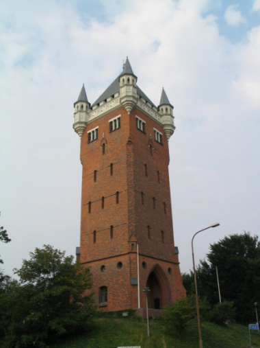 |
 |
Esbjerg Vandtårn (water tower)
|
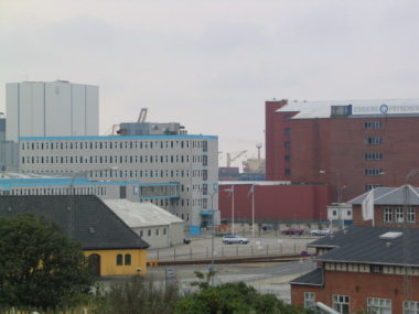
Esbjerg harbour |
Along with the shipping development the navigation and lighthouse system
were established – especially around the new harbour in Esbjerg where both
onshore lighthouses were build and lightships placed. The most prominent
lighthouse is, however, located at
Blåvandshuk (the most westerly point of
Denmark) and was established in 1888 (the present tower is from 1900) to
warn about the shallow waters of Horns Rev (reef), stretching over 40
kilometres to the west, which has resulted in countless shipwrecks over
time. The reef was for that reason named “Duyvels Horn” – the devils reef –
by the Dutch.
At the end of the 1800s electricity supply was established and throughout
the 1900s it was extended. Today some former power stations are used for
other activities: Esbjerg power station from 1907 is now The Academy of
Music of West Jutland (Vestjysk Musikkonservatorium) and Ribe power station
established in 1923 has become The Museum of Vikings (Museet Ribes Vikinger).
Infrastructure
The infrastructure was extended with the establishment of railways and roads.
The rail section Lunderskov-Esbjerg-Varde was introduced in 1874. In 1875
the section Bramming-Ribe was introduced, and in 1887 the section
Ribe-Tønder was opened. The establishment of railway stations added a
certain growth to the towns. The village
Hviding south of Ribe is an example
of this development.
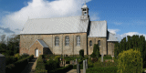
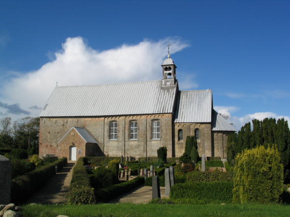 |
| Church of Hviding south of Ribe |
Until the 1920, when the Danish–German border was moved
to its present position, Hviding functioned as frontier station having a
complex of German and Danish station buildings. Altogether they made up the
longest railway station in Denmark. In 1922 the old frontier station was
replaced by a psychiatric hospital, which has been extended several times.
Tourism
A characteristic feature is that almost all recreational cottages are
located north and west of Esbjerg. In the 1900s the dunes and beaches by
Blåvand began to attract townspeople and tourists. The first summer cottages
were built here in the 1930s often using washed up timber. This was the
beginning of the tourist boom characteristic of the Blåvand area today.
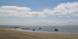
In Marbæk (north of Esbjerg) and by
Sneum Sluse east of Esbjerg the first
“do-it-yourself” cottages emerged in 1930s for recreation (fishing and
hunting).
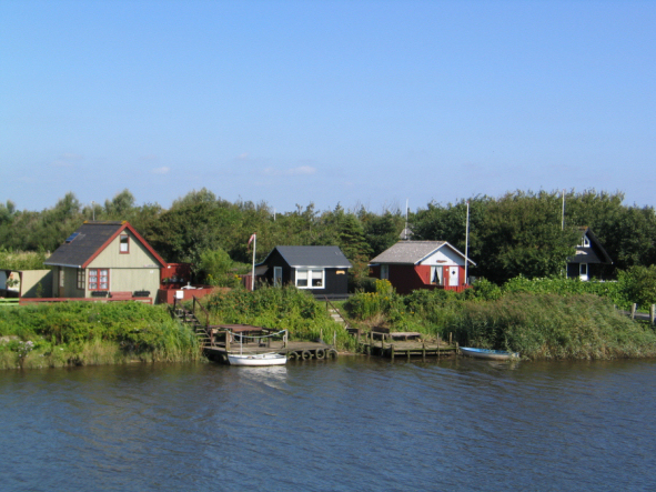 |
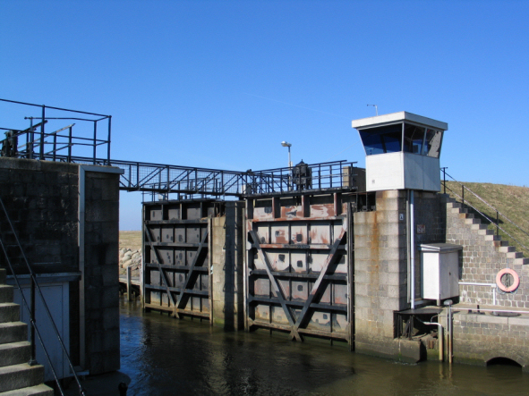
| Sneum sluse east of Esbjerg |
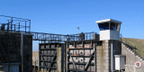
A similar cottage cluster at
Ribe Kammersluse was commenced
earlier.
In Ribe the tourist association was founded in 1899, aiming through its work
of preservation of the old houses to promote the town as an important
tourist attraction.
4. Modern development and planning
4.1 Land use
150 years ago the nature areas or half-culture areas with grazing or another
form of extensive agriculture formed approximately 60-70% of the country.
Today it is approximately 10%.
In the latest 35 years the EF/EU has played an increased role regarding the
land use in the rural areas (agriculture and nature), also in the Wadden Sea
Region. The EU Common Agricultural Policy (CAP) has contributed to the
cultivation of many coastal habitats, e.g. marshlands, with a severe impact
on the cultural landscapes and assets. Cattle, however, still plays an
important role within the region although the continuous structural
development is reducing the number of farms and many farms have switched
from cattle to pigs.
The introduction of the environmental directives (EIA, Birds-, Habitats and
Water Framework directives), the EU set-aside schemes and EU nature
restorations programmes (Life) has changed this development. In 2003 EU
introduced a CAP-reform, which aims at integrating production together
environmental-, natural- and cultural aspects, just as it should also be
more multifunctional. All these new regulations provide a possibility to
regain cultural values of the past in the Wadden Sea Region.
|
1. |
The west coast.
Today the area has almost no agriculture and solely consists of
nature- and half-culture areas and plantations, with large areas laid
out for summer cottages and military training grounds. Large areas are
today owned by the state.
|
|
2. |
From Skallingen to
Varde Å. Skallingen remains in its actual nature stage with
grazing on part of the salt meadows. Today, the area must be
considered as the most original of the landscapes in the Wadden Sea
region (state property). The salt meadows along
Ho Bugt and Varde
Å-valley are mainly grazed areas and wetlands. This is especially due
to a nature restoration project, which was initiated in mid 1990s (EU-Life
and set a-side schemes) with a 20 year time horizon in order to
restore the earlier cultural landscape.
|
|
3. |
From Varde Å to
Esbjerg. The eastern part is today a mixture of intensive
agriculture areas and more constant grass areas. Moreover, the area
holds smaller heath areas, which shows how the area looked before the
land reform movement. The most westerly part holds several spare time
agricultural holdings (horses- and riding centres) and mink farms. The
Marbæk area in NW is almost without agriculture but holds plantations
and heath areas, and is mainly used as recreational area for Esbjerg.
|
|
4. |
From Esbjerg to
Darum. The hill island is dominated by intensive agriculture with
large pig- and cattle farms and several mink farms. By Tjæreborg there
are comprehensive gravel pits, which have been enlarged during the
latest decades. Måde Enge (non-embanked) consists of forest of reeds
and grazed fields. In parts of the embanked marshland between
Tjæreborg and Darum several different types of wind mills have been
erected and a larger lake area has emerged in connection with the
reinforcement of the sea dike in 1990s.
|
|
5. |
From Darum to Ribe.
Today almost all marshlands here are grass in rotation and grain crops.
Only small parts are wetlands and permanent grass.
|
4.2 Settlement development
Housing and industrial estates
Since the 1960s the communities of Varde, Ribe and especially Esbjerg have
developed with large housing and industrial estates. The town of Esbjerg has
like many other communities encircled surrounded villages, which has caused
much impact at the former cultural and landscape assets there.
Due to the river system running through Ribe with high water levels in the
winter term in the surrounding meadows (wetlands) the medieval town centre
is still exposed and visible from north and west. This is a unique feature
in Denmark. To some extend this feature is also valid for the town of Varde.
Tourism
In the area by Blåvand and Ho most of the old summer cottages have been
converted into modern all year-cottages and many new have been added (approximately
3,500 cottages). Furthermore there are large camping sites and holiday
apartments with varied offers of recreational all year facilities. Today
this area is one of the largest recreational areas in Denmark.
Also the cottages by Marbæk,
Sneum Sluse and
Ribe Kammersluse have been
extended and developed according to the more modern time.
 |
| Ribe
Kammersluse |
After World War II a cluster of cottages emerged and developed as a near
recreational area for Esbjerg.
Except for the establishment of a large number of holiday apartments in Ribe
(Ribe Byferie) and the establishment of a number of smaller camping sites,
there have been no noticeable tourist extension south of Esbjerg.
Military and War activities
Since 1929 coastal areas west of the town of Oksbøl have been designated as
national military excise ground and a permanent military camp was
established. During World War II the German occupying forces took over and
the exercise ground and camps were extended.
At the end of the War and up to 1948 a German refugee camp with 36,000
refugees lived in the camp (the sixth largest town in Denmark then). The
cemetery, where 1800 refugees and soldiers were buried, is still visible in
Oksbøl.
The entire coastline within the entity was part of the “Atlantic Wall” of
World War II. In Denmark nearly 1800 larger and countless smaller bunkers
were built and many of them (or part hereof) can still be seen all over the
coastal area, also at many locations in the dune area. The bunker “Tirpitz”
by Oksby, a never finished emplacement bunker from 1944 is one of the most
spectacular sites.
The area around Esbjerg was one of the most fortified areas in Denmark
during the War. Esbjerg had the only harbour, which could be used in case of
an invasion by the allied and therefore an important strongpoint for the
German occupying forces. At many places along the coast north of Esbjerg (Sjelborg)
several German facilities are still visible.
After the War the shooting range by Oksbøl was re-established as a military
training area. In the 1960s a large expropriation was carried out, which
among others affected 60 farms and 42 permanent habitations. Many of the
properties are still present and a part in the military trainings – the
fronts illustrate the bygone days. Today the training area covers
approximately 6,000 hectare (dune, moor, marsh and forest). Approximately
half of this area is located within the entity.
4.3 Industry and energy
After World War II the fishery developed and Esbjerg became the largest
fishery harbour in Denmark (late 1960s it peaked with 600 vessels). The
harbour has been enlarged several times and is today among the four largest
harbours in Denmark with a multi-faceted composition of activities:
container and passenger traffic, edible- and industrial fishing, offshore,
ferry traffic, shipyard, power station and several harbour related companies
such as fishmeal production. Today less than 50 fishing vessels are left,
but Esbjerg has become the offshore harbour number one in Denmark.
Today the most visible industry of the harbour is development of energy: the
coal-burning power station with the highest chimney in Denmark (250 metres)
and the refuse disposal plant from 2003.
At the end of the 1970s the modern windmill industry emerged and many
windmills and wind farms have been erected since then all over Denmark, but
most dominant in the westerly (windy) part of the country. Within the entity
the main part is located east of Esbjerg– some even into and at the edge of
the marshlands.
In 2002 the world’s largest offshore wind farm was built at Horns Rev in the
North Sea, 14-20 km west of Blåvandshuk.
4.4 Infrastructure
The main road traffic arteries were main road A1 (Esbjerg-Copenhagen) and
main road A 11 (along the west coast). The increased road traffic in second
half of 1900s has caused many new road constructions, often with severe
impact on the cultural landscapes. Some examples are:
|
• |
The
medieval towns Ribe and Varde have both been subject to construction
of westerly bypasses, respectively in 1950s and 1990s crossing the
vulnerable cultural landscapes (marshlands and stream valley). |
|
• |
In
1998 the A1 was replaced by a highway leading almost to the harbour of
Esbjerg.
|
5. Legal and Spatial Planning Aspects
All salt marshes and almost all embanked marshlands are included in
the Trilateral Cooperation Area and are also part of Natura 2000. Moreover,
many (small) inland habitats like bogs, heathers and meadows are preserved
under the national Nature Preservation Act.
Also preservation regulations of buildings (churches) and ancient monuments
(burial mounds) and their surroundings are common features in the rural
areas.
Preservations and (strict) regulations in urban areas, e.g. medieval town
centres of Ribe and Varde, have been introduced since many decades.
In relation to spatial planning, Denmark is divided into three zones: the
urban zone, the rural zone and the summer cottage zone, in which there are
different regulations to achieve different objectives and preferences.
In order to protect the coastal zone of Denmark, in particular, a three
kilometre wide protection zone from the coastline (outside towns) has been
introduced with the aim to keep clear of buildings and constructions which
are not pending on the coastal position. Moreover, recreational facilities
can only be located inside this zone in combination with already existing
facilities or urban areas.
It should be mentioned that the official policy states that no new areas for
windmills -and farms will be appointed, and that renewal of existing
windmills will only be allowed in the rural zone on special conditions in
relation to landscape and cultural features and assets.
In connection with the extension of the energy supply a master plan for the
rationalization of the existing high-voltage transmission lines has been
decided. Within the entity it includes dismantling of lines crossing The
Wadden Sea, Varde Å Estuary and through other vulnerable nature areas and
landscapes.
From 2007 and onwards the main responsibility of the administration of rules
and regulations and the overall spatial planning will be located at the
three municipalities. Among other things they will be obliged to map,
designate and preserve the main cultural heritage and be requested to take
similar actions regarding the landscape features. Apart from this the
municipalities have already the powers to issue a “preservative local plan”
to protect specific and local cultural features.
6. - 7. Vulnerabilities and Potentials
In general the main threats to the landscape character and cultural heritage
are urbanisation, including visible elements like windmills -and farms and
high voltage transmission lines, infrastructure, recreational activities,
agricultural changes and afforestation.
The villages in the Danish part of the Wadden Sea Region are among the best
preserved in Denmark mainly due to economical stagnation in the area in
1900s. Today, the majority of the villages are “drained” of functions. With
the comprehensive structural changes within agriculture it is expected that
even more holdings will be given up and agricultural facilities will become
redundant. One the other hand it can be expected that there will be fewer
farms but considerable larger agricultural buildings. These are all ready
visible in the landscape today.
As the entity contains a great variety of landscapes and cultural
environments one has to distinguish:
|
1. |
Between Ho and
Blåvand the area is influenced by the heavy tourist pressure (more
than 1 million visitors a year) both wear problems of the landscape
but also the high number of new cottages around Blåvand, in particular.
To this also the increasing camp sites and other amusement facilities
to match.
|
|
2. |
From Skallingen
to Varde Å the characteristic building pattern must be preserved
also by avoiding new buildings and installations here (the wind farm
located at Kjelst underlines this point). The areas are very
vulnerable with regard to new buildings, installations, plantation
etc., which can blur the clear border between the meadows and the
buildings at the ridges or visually parcel out the large, coherent
meadows. Especially buildings and plantation, which will hinder the
free view to and from the churches, should be avoided, but also the
open view between the building clusters to the marsh areas. Moreover
the areas can be threatened by more discontinuations of farms, change
in cultivation in the marsh and draining, which may blur the division
and thereby the complicated property conditions.
Varde Å and the estuary have regularly been subject to discussions
concerning embankment. However, the recent developments regarding
agricultural subsidies and a nature restoration project have abandoned
this (discussion) – at least for some decades!
|
|
3. |
From Varde Å to
Esbjerg. In order to preserve the characteristics of the landscape
agriculture should be maintained. Also the richness of the ancient
monuments (burial mounds) and their surroundings must be preserved.
The development of Esbjerg especially to the north must take these
aspects into account.
The “skyline” of Esbjerg dominates and influences the long distance
perception of the landscape. Entering from the east the mixture of
industrial sites and plants, high-voltage cables, etc, etc. is a
disastrous connection between the city and its surroundings.
|
|
4. |
From Esbjerg to
Darum. In order to preserve the character of the area a continued
farming, preservation of villages and field structures and the old
farms is of importance. The cottages by Sneum Sluse (lock) and
Kammerslusen are not very special individually but together the close
buildings and the special charm should be maintained.
|
|
5. |
From Darum to
Ribe. The very characteristic building and field structure with
large villages on the geest edge and the narrow ditched parcels should
be preserved. A special characteristic for the villages along the
marsh is the large undeveloped thwarts with a view over the flat
landscape. The vulnerabilities mentioned in 2 are also valid for this
area. It is important for the maintenance of the characteristic of the
marshlands “in front of” Ribe that the area is kept wide open and that
the meadows are grassed. More grassing areas will support the
character of the landscape in the direction towards the original
utilisation and make the connection between the cultural historical
origin and the nature foundation evident. In order to preserve the
wide view the area should be kept free from technical installations
and high stands. The original character of the landscape will be
strengthened if the streams are restored to their original appearance.
|
|
6. |
Ribe. The
increased utilisation of the fertile marsh soil has special
consequences for the preservation of the medieval town centre in Ribe.
The town is built upon a “cultural sponge” which constantly requires
moisten in order to maintain a well-established foundation of the old
buildings. The farmers on the other hand prefer a low water level in
the spring and summer seasons at the meadows east of the town, in
particular. This practice has contributed to increased subsidence of
the houses in the town centre.
The wide and undisturbed view to the town centre and the cathedral of
Ribe is probably the “conventional wisdom” of the Danish marshlands.
Town developments (industries and housing sectors) and road
constructions with extensive use of lighting have reduced and in many
cases deteriorated this unique feature. |
8. Sources
Author: Charlotte Lindhardt and John Frederiksen
Sources: Lancewad – Landscape and Cultural Heritage in the Wadden Sea
Region, 2001
Kulturarvsstyrelsen: 1. Arbejdsrapport, Karakteristik af hovedtræk, 2006.
Regionplan 2016, Ribe Amt.
Maps: Kort- og Matrikelstyrelsen©
Photographs: Charlotte Lindhardt, Kulturarvsstyrelsen©
Links: Cultural environments in the Northern Danish entity:
1. Blåvand Fyr, radio mm.
2. Oksby Klitlandbrug
3. Varde Ådal
4. Janderup Kirke og ladeplads
5. Hesselmed
6. Visselbjerg og Vibæk
7. Varde middelalderlige byplan
8. Arnbjerganlægget
9. Marbæk Plantage
10. Hjerting
11. Esbjerg Havn
12. Jernbanen og Exnersgade i Esbjerg
13. Esbjergs torv og centrum, gridplanen
14. Kirkegadekvarteret med Sct. Josephs Hospital
15. Spangsbjerg Hospital
16. Novrup
17. Krogsgård og Krogsgård Mark
18. Sneum, Nybro, Tømmerby, Sneum Kirke, Sneumgård
19. Sneum Sluse
24. Finnebyen, Esbjerg
25. Tjæreborg Sønderby, Roborghus
26. Højgruppen ved Hoffmanns Plantage
27. Darum
28. Riber Kjærgård
29. Kongeådalen, Vilslev, Vilslev Spang, Jedsted
30. Ribemarsken
31. Ribe Kammersluse
32. Ribes middelalderlige bykerne
33. Ribes villakvarterer
34. Riberhus
35. Vester Vedsted
36. Hviding Nakke og bebyggelsen på bakkeøen
38. Ribe Plantage og Galgebakken
39. Egebæk-Hviding Station
40. Farup Kirkeby, Kærbøl, Nr. Farup
|