|
1. Overview
|
Name: |
Altes Land |
|
Delimitation: |
River Elbe, river
Schwinge, geest border, neighbouring entity Land Kehdingen |
|
Size: |
Approximately 264km² |
|
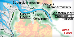
Location
- map: |
Tidal river marsh of
Lower Saxony and the federal state of Hamburg, Lower Saxony and
Hamburg, Germany |
|
Origin of name: |
‘Old Land’ |
|
Relationship/similarities with other cultural entities: |
Plantation landscape,
rural house form, aligned settlement, parcel of land of the
traditional Dutch cope size, swan-shaped gables as an architectural
feature point to northern Flanders, brick works in the Elbe marshes |
|
Characteristic elements and
ensembles: |
Marshland and Geest edge
landscape, yardland settlement, brickworks, fruit-growing |

2. Geology and geography
2.1 General
The Alte Land (“the Old Land”) is an approximately 33 km long and up to 8 km
wide marsh strip south of the lower Elbe. The cities of Stade on the
Schwinge, Horneburg on the Lühe and Buxtehude on the Este are located on its
borders. Historically the area was divided between the Lower Saxony and
Hamburg territories.
The First Mile lies between the rivers Schwinge and Lühe, the Second Mile
comprises the area east of it between the Este and Süderelbe.
The area is characterised by the Elbe marshes. These alluviums were created
following the end of the ice age in the glacial valley of the Elbe. The
southern border of this is formed by moor land which was not settled until
the late 19th century and which lies as a broad border strip in front of the
geest, the latter rises up to 40 m in some places.
2.2 Present landscape
Today the Altes Land is a smoothly reliefed (does this mean gently sloping ?
no, some kind of a slight relief) plantation landscape which owes its
fertility to the alluvial marsh lands. The modern landscape is still
dominated by its marsh yardland villages and the straight-lined drainage
ditches. This historic pattern of land use with a settlement emphasis along
the strongly meandering rivers Lühe and Este has hardly changed.
Geomorphologically the alluvial marsh land is enclosed by the Geest to the
south. Along the Geest edge, through the Altes Land there used to run an
important trade route leading from Stade/Hamburg over Hanover, Frankfurt to
Basel, the course of which is now followed by the federal road B 73. Roughly
parallel to it the Altes Land is crossed from the north-west to the
south-east by the road leading from Stade to Moorburg. From this, roads
branch off nearly at right angles, forming a north-south axis.
Important features of the Altes Land are the parallel running,
straight-lined drainage ditches. They enclose the yardland estates which
usually are positioned at right angle to the banks following the courses of
the rivers. If there was enough room then each settlement entity comprised a
2,25 km long and 150m wide yardland estate which again was divided up by
drainage ditches into ca. 20 m wide strips. The long narrow parcels in the
area between Stade and the Lühe are orientated towards the Elbe. In the area
of the Lühe and the Este however they are orientated towards the river bank.
3. Landscape and settlement history
3.1 Prehistoric and Medieval Times
The wide-ranging study of the Northern German Wadden Sea is much advanced,
not least due to the efforts made by the Institute for Historical Coastal
Research and by communal and district archaeologists. As a comparatively
young geological landscape the Elbe-Weser region is dominated by quaternary
alluvials. Contrary to the Geest bordering on the Altes Land, the river
marshes of the Altes Land and the peatlands which used to border the Altes
Land towards the Geest are basically still growing.
Archaeologically speaking, the exact date of settlement in the Altes Land
has only been indirectly documented. On the basis of comparison with the
surrounding regions it can be assumed that the Altes Land has been occupied
since the prehistoric period.
At the beginning of the Holocene today’s southern North Sea coast was firm
land and the North Sea cost lay in the area of the Doggerbank. It can be
presumed that the former river marshes of the Altes Land would have been
frequented by Mesolithic foragers. Neolithic settlement in the area is
demonstrated by two flint daggers. It is possible that the river marshes
contain sites of this period, and this possibility should be considered when
dealing with future maintenance works in the rivers. In particular it is
possible that when extending or dredging waterways, occupation layers could
be cut into and thus could erode without being noticed.
The Bronze Age in the Elbe-Weser region is represented by various sites,
such as burial mounds and urn-cemeteries. Similar forms of evidence survive
from the Roman Iron Age and the following Migration Period. Between the
early 6th to the late 7th century reforestation appears to have taken place
and former cultivated areas were given up.
In medieval times the area was resettled. The First Mile was dyked first and
settled after 1140. The dyking of the Second Mile was completed at the end
of the 12th century and that of the Third Mile was completed only towards
the end of the 15th century, since the area was very much endangered by
storm tides.
As an example of the resettlement of the First Mile, the parish of Hollern
can be cited. It lies in the lower hinterland, the Sietland, which was
systematically cultivated in the 12th century. From the place names such as
Ditterskop, which has already been documented for the year 1140, the
presence of settlers from the Netherlands can be deduced. The name Hollern
only became common in the 17th century. The settlement of Hollern consists
of a marsh yardland settlement, approximately four kilometres in length,
which today is characterised by an unusually uniform impression of the
combined dwelling and farming buildings. In Hollern itself, the church
tower, is of probable 12th century date and is perhaps the oldest surviving
building in the Altes Land.
The parish of Jork is sited within the Second Mile. It is first documented
in the year 1221. The settlement was constructed systematically along a
routeway, the present country road 140. Originally most of the farmsteads
lay on the southern side of the road, with the settlement centre at the
junction of the east-western road and Jork’s main drainage system
(Hauptwetter) which flowed northwards. The church lay to the south-east and
the double yardland of the manor on the north-eastern side of the junction.
On the western side lay the farmstead of the Andreas monastery, the
“Verdener Farmstead“, also consisting of two yardlands. This village centre
was to be subsequently further consolidated around the church with the
addition of craftsmen, shippers (does this mean sailors or ship-builders ?
both of them as I know) and traders’ dwellings and businesses.
3.2 Early Modern Times
At the beginning of the early modern period, under Archbishop Christoph
(1511-1558), the autonomy of the Altes Land ended with the introduction of
the archiepiscopal county order. The associated privileges of
self-administration remained in place into the 19th century.
The various military occupations of the area during the Thirty Year’s War
put the region under a lot of pressure and the period after the Westphalian
Peace of 1648 brought further impoverishment upon the population. The
Swedish occupants built their seat of government in Agathenburg and
strengthened Stade’s fortifications. In 1712 the Swedish sovereignty was
replaced by the Danish dominion and 1715 the Danes sold the region to the
electorate of Hanover.
From an economic point of view the Altes Land was largely agriculturally
based. This was due to the fact that the Elbe marshes provided the
agricultural goods for the markets along the coastal road. Decreasing crops
and the competition with overseas producers lowered the yields and caused
numerous closing downs (= farm closures) (?bankruptcies). The population
often didn’t have another choice other than to emigrate. During this period
there was a shift from arable production to pasture, particularly cattle and
horse breeding, and the development of fruit production. In the 18th century
it is known that the Altes Land was exporting fruit to the Netherlands.
3.3 Modern Times
The administrative reforms in the middle of the 19th century brought the
institution of the Office of Jork with it, which was sited in the so-called
Portau’schen Haus currently used as bibliotheca. In 1885 the Office was
turned into the district of Jork, after the kingdom of Hanover had become a
Prussian province. The political entity which had existed since the medieval
land-taking ended in 1932, and the Altes Land became a part of the district
of Stade. From the parish reform between 1969 and 1971 the Einheitsgemeinde
(combined parish) of Jork and the joint community Lühe finally emerged.
The regional development of the Altes Land has long been influenced from the
growth of the surrounding towns Stade, Buxtehude and especially of the free
and Hanseatic city of Hamburg. This influence is notable in the
architecture. Modern construction methods and house forms are spilling into
the Altes Land from the Elbe riverside settlements Borstel and Grünendeich.
This urban influence declines the further you move into the hinterland.
One important influential factor was the development of the brick making
industry. This in the area of the Elbe marshes focussed on South Kehdingen,
but it also influenced the historical development of the Altes Land in the
19th century. The principal requirements for this industry were the kley
soils of the marshes used as brickearth and the proximity to the water
courses. For a time brick production was the most significant part of the
economy in the areas to the west of the Elbe. Production and demand was
however dependent on the economic and building requirements of Hamburg.
Demand was particularly high as a consequence of the rebuilding of Hamburg
after the big fire of 1842. The foundation years and the joining of Hamburg
to the German customs union with its associated building of the
Speicherstadt (a quarter consisting only of storage buildings) in 1885 were
also significant. During this period the number of brick works in the Altes
Land rose from four to 32 workshops. However, by 1900 most of these sideline
businesses had already vanished.
A further important branch of the economy was the spread of fruit-growing in
the early 20th century. Fruit-growing in the Altes Land dates back as far as
the 14th century and for the year 1657 there are 102 fruit farms documented
which together covered some 51 ha. The Altes Land orchards expanded
considerably following 1870, reaching their greatest extent in the 1960s. In
effect, it completely displaced arable and stock agriculture, replacing it
with a plantation landscape of fruit-trees and bushes grown in long straight
lines. Together with the marsh yardland villages these orchards are the most
dominant feature of the modern landscape. The growth of the orchards was
accompanied by the foundation of the Jorker district fruit growing school in
1867, and of the fruit growing experimental station in 1935.
In addition to the rather poor road and path network, the waterways were the
traditional means of transport and communication in the Altes Land. In 1863
the Altes Land was indirectly connected with the transport network by the
Stade-Buxtehude (the present B 73) following the Geest ridge and in 1881 the
railway line Hamburg Cuxhaven was also built on the Geest ridge. In 1893 the
Moorburg-Jork-Stade road, which runs straight through the Altes Land, was
built.
4. Modern development and planning
In its regional development report of 2005 the federal office for
building and regional development attributes the Altes Land to the regions
where the development of the population and employment is characterised by
intense growth. This development is leading to an ever-growing demand for
building land, and is accompanied by increased traffic volumes.
4.1 Land use
The Altes Land is a plantation landscape specialising in fruit-production.
The northern areas in particular are characterised by rather unfavourable
natural and business conditions of production. Some 9000 ha. of farmland are
intensively farmed, and it is anticipated that this will expand further,
impacting on other businesses. At present the percentage of employees in the
agricultural sector lies below 14% and this could decrease even further.
The Altes Land also has a tourist role, largely based on the agricultural
landscape of the area. In this context the historic field structures,
agricultural buildings, dykes, drainage ditches as well as technological
monuments such as sluices etc. are of particular importance.
4.2 Settlement development
The proximity of the Middle Order Center Stade and the High Order Center
Hamburg has had a direct influence on the Altes Land. Since the beginning of
the 1990s a steady population increase has been documented. In the Regional
Report Northern Germany 2005 of the Institute for Economic Research of Lower
Saxony this is mirrored in the intense rise in commuting from the Altes Land
towards Stade and Hamburg. It can be anticipated that the extension of the
A-26 is going to increase the commuting trend even further. In the long term
this might pose the danger of the Altes Land turning into a mere residential
area which could lead to a massive loss of identity currently based on
economic traditions. Furthermore, continuing urban sprawl can be expected.
The Altes Land does not possess a district- or supra-regional museum. In
Jork there are the regional museums Estebrügge illustrating the history of
the Altes Land and the Museum Altes Land dealing with the technological
history of the Altes Land. Then there are the Altländer Schiffahrts-Museum
in Twielenfleth with its exhibition of ship models, and other attractions
like the special event days offered by some farmsteads or public guided
tours e.g. in Estebrügge, Hollern-Twielenfleth, Jork, and Steinkirchen. In
the restored harbour of Steinkirchen the ferry „Lühe“ can be visited.
On the border of the Altes Land in Horneburg is the crafts’ museum
illustrating the history of the coaching inn, carriers and related crafts
and trades of the 17th to 19th century. In Buxtehude there are two points of
interests to be found. On the one hand the Buxtehude museum about the
regional history and art and on the other hand the Marschtorzwinger/
Liebfrauenkirchhof with changing exhibitions. In Stade itself the
Maumhausmuseum (Alt Stade), the artillery fort Fort Grauerort, the open-air
museum, the museum of local history, the Kunsthaus Stade, the museum for the
adopted town Goldap in Eastern Prussia, the Schwedenspeicher (Swedish
storehouse), the technology and traffic museum Stade/Elbe as well as the
Naturkundemuseum (museum for natural history) Stade are to be found.
4.3 Industry and energy
The Altes Land is situated between the higher ranking industrial sites of
Hamburg, Buxtehude and Stade/Bützfleth with its main focus on
petrochemistry. In the city of Stade there is a nuclear power plant and
there is a transformer station in Rollern. The gas and crude oil pipelines,
leading from Hamburg across the Altes Land, should also be mentioned. There
are no wind farms in the Altes Land.
4.4 Infrastructure
The traditional means of integrated transport in the Altes Land has always
been waterways and streets (the long-distance road Stade-Buxtehude), with
the Elbe providing a means of communication into regional and national
economics. By 1863 the indirect integration of the Altes Land into the road
network of Lower Saxony took place with the construction of the road from
Stade to Buxtehude (today B 73) following the geest ridge and 1893 with the
building of the country road 140 running straight across the Altes Land and
leading from Hamburg over Jork to Stade. Before then, the paths and roads
were not surfaced. Hence the custom of walking on stilts developed in this
region. The district road 26, which crosses the country road 26 at right
angle, offers a north-south connection between the northern Elbe to the
southern geest border.
The planned Autobahn A-26 will clearly increase the commuting radius from
commuters from the surrounding region or from Hamburg. At present the Altes
Land is still characterised by a rather poor access to the Autobahn A-1
respectively A7.
Considering the proximity of the Elbe, the rivers Schwinge, Lühe and Este
serve as access routes to its important function as a federal waterway.
The train network of the Altes Land is connected by the town of Stade. The
rails run parallel to the B 73 along the Geest ridge and parallel to the
Altes Land.
5. Legal and spatial planning aspects
The Altes Land is historically divided into three parts of roughly equal
size which are aligned with the rivers Schwinge, Lühe and Este. Today the
Third Mile lies on Hamburgian territory. Since 1972 the part belonging to
Lower Saxony consists of the Einheitsgemeinde (fusioned parish) of Jork and
the joint community of Lühe with the parishes of Grünendeich,
Guderhandviertel, Hollern-Twielenfleht, Mittelnkirchen, Neuenkirchen and
Steinkirchen. Jork takes up all of the eastern part of the Altes Land which
belongs to Lower Saxony. The parishes of the Old or Lower Saxony Land fall
under the regional authority of Stade.
With regard to the spatial planning for the area, the parishes of the Altes
Land are subject to the land-use regulation program of Lower Saxony, and to
the landscape framework plans and land utilisation plans laid down by the
parishes. In addition, the regional development plan for Hamburg and the
land use regulation framework for the coastal area of Lower Saxony will have
to be considered in any further development or management plans.
6. Vulnerabilities
6.1 Spatial planning
The intense growth in population and employment is creating an ever growing
demand for building land which in turn creates increased traffic flow. The
establishment of extensive industrial estates and business parks (e.g.
Industriepark Unterelbe), as seen in the example of Airbus on Hamburg
territory, can seriously disrupt traditional small scale industries and have
a significant impact on the landscape and buried archaeological deposits.
6.2 Settlement
The extension of the traffic network, with the construction of the Autobahn
A-26 and possible extension of the A-22 will clearly increase the commuting
radius, which could lead to an influx of commuters into Altes Land. The
Altes Land could turn into a mere dormitory town and the identification of
the residents with the traditional income structures and local identity
might get lost. The pressure to increase agricultural production has lead to
a significant decline in farmsteads in the Altes Land.
6.3 Agriculture
The change in agricultural production methods has meant that the Elbe
marshes with its typical narrow long leas pose a problem because they are
not designed to be farmed with large machines. The present landscape also
makes it difficult to use the fruit production methods which are regulated
by the EU (Ramsar-Convention). Consequently farms will have to increase
their agricultural areas to remain competitive and there is the possibility
of the Altes Land could change into an industrially farmed monoculture.
6.4 Tourism
The promotion of the Altes Land as a tourist centre could have two separate
impacts. Firstly it could lead to an attempt to ‘freeze’ the region in its
present state, thus preserving the entire cultural heritage, but with major
economic problems probably arising as a result. Alternatively, it may lead
to the abandonment of traditional buildings to adapt to the needs of modern
mass tourism. The expansion of tourism infrastructure may threaten buried
archaeological deposits.
7. Potentials
7.1 Spatial planning
The closeness of Hamburg brings economic wealth to the region, but it
increases the demands for space, since the “Altes Land” offers high quality
living in a rural setting. Spatial planning needs to take the opportunity to
exploit the important surviving historic landscape within its sustainable
tourism. The cultural identify of the area should be promoted via integrated
strategic planning when developing new industrial and residential areas.
7.2 Settlement
The historic settlement pattern, as seen in the Marshhufendörfer (marsh
yardland settlements) of the 12th century with their long narrow leas is
mostly intact and the important connection between villages and the
marshland survives. This provides an important resource to promote the
cultural identity of the area both to the existing occupants and the
increasing numbers of commuters relocating to the area.
7.3 Agriculture
Unlike many areas the historic landscape survives very well, characterised
by the yardland settlements. This landscape and the settlements provide an
important resource to base sustainable tourism on. The extensive orchard
plantations are an important historical landuse and the industry could be
promoted and protected in its present form.
7.4 Management of cultural heritage
Altes Land is characterised by a high density of surviving monuments
especially in the region of the river marsh on both sides of the Lühe there
are, early Neolithic deposits, combined residential and farming buildings
which date from the 17th to the 20th century and the industrial brickworks
of the 19th century.
7.5 Tourism
Altes Land is characterised by an important surviving historic landscape,
numerous religious buildings and a network of historic road and path
networks. There are numerous museums presenting the material culture and the
history of the region. Tourism can take further advantage of landscape and
cultural assets, e.g. via integrated tourism with the museums, nature
conservation bodies and cycle/footpath routes.
7.6 Maritime history
The hamlet of Gründendeich, developed early into an important shipping
centre on the lower Elbe thanks to its favourable situation on the Lühe
estuary. The marine monuments (such as beacon, navigation school and
shipyard) provide a source for potential promotion of the maritime history
of the area.
8. Sources
Author: Ulf Ickerodt
Behre, K.-E. (1995): Kleine historische Landeskunde des Elbe-Weser-Raums.
In: Geschichte des Landes zwischen Elbe und Weser I. Vor- und
Frühgeschichte. Stade
Bundesamt für Bauwesen und Raumordnung (BBR;2005): Raumordnungsbericht 2005.
Berichte 21, Bonn
Denkmaltopographie Bundesrepublik Deutschland (1997). Baudenkmale in
Niedersachsen Landkreis Stade. 26.1. Landkreis Stade ohne die Städte Stade
und Buxtehude, bearbeitet von Heike Albrecht. Hameln.
Ehrhardt, M. (2003): „Ein guldten Bandt des Landes“. Zur Geschichte der
Deiche im Alten Land. In: Schriftenreihe des Landschaftsverbandes der
ehemaligen Herzogtümer Bremen und Verden 18. Geschichte der Deiche an Elbe
und Weser 1. Stade.
Hoffmann, H.-C. (1986): Bremen, Bremerhaven und das nördliche Niedersachsen.
Kultur, Geschichte, Landschaft zwischen Unterweser und Elbe. Köln.
Hofmeister, A. E. (1979): Besiedlung und Verfassung der Stader Elbmarschen
im Mittelalter I. Dies Stader Elbmarschen vor der Kolonisation des 12.
Jahrhunderts. Hildesheim.
Raumordungskonzept für das niedersächsische Küstenmeer (2005). Herausgegeben
vom Niedersächsisches Ministerium für den ländlichen Raum, Ernährung,
Landwirtschaft und Verbraucherschutz - Regierungsvertretung Oldenburg -
Landesentwicklung, Raumordnung. Stand 2005.
Röper, C. (Hrsg.; 1988): Bilder und Nachrichten aus dem Alten Land und
seiner Umgebung. Bearbeitet von C. Röper, I. Carstens und L. Zupp. Bd. 1-3.
Jork.
Thieme, H. (1997): Älteres Paläolithikum aus dem Gebiet zwischen Weser und
Elbe. In: L. Fiedler [Hrsg.], Archäologie der ältesten Kultur in
Deutschland. Materialien zur Vor- und Frühgeschichte von Hessen 18, 328–356.
Wendowski, M. (1992): Landschaftsentwicklung und Besiedlungsgeschichte im
Alten Land. Methoden und Ergebnisse. Herausgegeben von der Gemeinde Jork.
Jork.
Full catalogue of historic maps used, survey evidence etc
Historische Übersichtskarte des Alten Landes. Handzeichnung des Drost und
Gräfen von der Decken aus dem Jahr 1781 (Ehrhardt 2003, 2-3)
|