|
1. Overview
|
Name: |
Auricherland |
|
Delimitation: |
:Geest, peatland,
neighbouring entities Harlingerland, Moormerland, Brookmerland |
|
Size: |
around 506
km² |
|
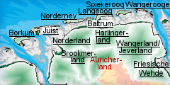
Location
- map: |
Part of East
Frisian-Oldenburg Geest-ridge and surrounded by former raised bogs,
Lower Saxony, Germany |
|
Origin of name: |
Not known |
|
Relationship/similarities with other cultural entities: |
Similar Heritage and
cultural landscape to Brookmerland and parts of Wangerland /Jeverland.
Used similar sod techniques on the Geest similarly to other Geest
areas such as Harlingerland. Fen settlements are based on the Dutch
models. |
|
Characteristic elements and
ensembles: |
Scattered villages,
embankment hedges, sod-technique farming, fen settlements, fenland
canals, fenland fields, horticulture |

2. Geology and geography
2.1 General
The historic cultural landscape of the Auricherland is part of today’s
district of Aurich. Located in the middle of East Frisia, it is delimited by
the Harlingerland to the north and today’s district of Wittmund. The
Moormerland borders it to the south of Bagband and the Lengenerland to the
southeast.
Aurich is on the flat East Frisian-Oldenburg Geest-ridge, which extends as
far as Oldenburg and is rarely higher than 10 m above sea-level. Broad Ice
Age valleys formed around the East Frisian Geest-ridge, in which developed
peatlands under the influence of the increasing sea-levels and the Atlantic
climate, dividing the Geest into small sections. The extensive raised bogs,
today largely stripped of their peat, have levelled out the earlier
differences in the terrain, so that the land now gives the impression of
being wide and level.
2.2 Present landscape
Today’s Auricherland is marked by constant variety in the use of the land,
including arable land, pasturage, wooded areas and wasteland, linear and
single settlements. The fact that arable land is mostly higher than the one
time common land is due to use of sods. The sod method of improving
fertility involved the cutting of sods of grass and heather on the common
land. These were taken to the byre, and then taken dung-saturated, into the
fields. Many of the embankment-hedges, typical of the region, which came
into being as land divisions on the Geest following the splitting up of
common land, have been destroyed by land re-organisation. However, there are
surviving examples around Bagband. Drainage ditches fulfill the function of
boundaries in the peat-bog/marshland areas. The landscape of the former
highlands comprises a mix of arable and pastoral agriculture.
The forms of settlement on the Geest are simple farms, hamlets, villages
which developed from individual farms and have grown into scattered
villages. The old castle town and residency of Aurich is the administrative
and educational centre for the region. Aurich is connected by the Ems-Jade
Canal to the towns of Emden and Wilhelmshafen. The town was enlarged in the
community reform of 1917 by the addition of 20 neighbouring communities and
has 40.000 inhabitants.
The raised bogs systematically opened up and settled since the 17th century
are marked by linear settlements along the marsh channels. In the
Auricherland fen settlements set up according to Dutch models are typical.
They are all near watercourses which were used for transporting peat, and
the settler’s houses were close to these. The community of Grossefehn, has
this settlement pattern, with Ost-, Mitte- and Westgrossefehn as its centre.
Some fenland settlements originate on the basis of the peat-burning culture.
Wiesmoor, which only came into being at the beginning of the 20th century,
is the most recently founded town, being granted a town charter in March
2006. Founded around peat-production for a power station, which closed in
1965, Wiesmoor turned into a gardening settlement with large tree nurseries
and gardening centres and is recognised as a climatic health resort.
3. Landscape and settlement history
The
Auricherland has a complex settlement history, and its marsh landscape
reflects man’s continual struggle to gain and preserve the marsh for human
habitation. Characteristic monuments of the process are the dykes, fens and
dwelling mounds. The large scale investigation of the North German mud
flats, as well as the Auricherland marsh and Geest, has been carried out by
the Archaeological Service of the East-Frisian Association (Ostfriesische
Landschaft) and the Institute for Historic Coastal Research (Institut für
historische Küstenforschung) among others, revealing a complex settlement
history.
3.1 Prehistoric and Medieval Times
Late Palaeolithic stone artefacts demonstrate that groups of hunters
frequented East Frisia. The Geest was cultivated since the Neolithic period,
c. 4000 BC, by groups of farmers, belonging to the west group of the Funnel
Beaker Culture. Unfortunately most of the best known monuments of this
period, the megalith burial places, have been destroyed. A burial place in
Tannenhausen still has three stones, one supporting and two covering stones.
In addition there are burials in single graves, as an example rich in
ceramics from Wiesens, demonstrates. A move to expand the useable land seems
to have occurred during the single grave culture of the later Neolithic
period. Finds from this period have been made in areas which have not been
previously exploited, such as the edges of the marshes, river valleys and
fenland. A bog track leads from Tannenhausen in the direction of the Ewiges
Meer in the district of Wittmund. Numerous remains of wagons provide
evidence for vehicle traffic at this time.
Single Bronze Age finds, some from the fens, have often been recovered. A
bronze lance tip has been discovered in Ochtelbur during peat-digging.
Prehistoric grave mounds have been preserved in the woods of Aurich. At
Wiesens a grave mound has been excavated, this had four long rows of double
posts which lead up to an oval row of posts. Finds from the Bronze Age have
also been made in Wiesens. A number of remarkable finds have been made in
the fens and peat-bogs. These include the golden disc of Moordorf, which is
west of Aurich and actually belongs to the Brookmerland, interpreted as
belonging to a cult-chariot comparable to the sun-chariot of Tundholm. The
famous plough of Walle, found on Tannenhausen Moor during peat-digging is
from the early Bronze Age. In the Bronze Age the damper locations used for
settlement in the late Neolithic period seem to have been avoided. In the
later Bronze Age and the pre-Roman Iron Age, cremation became the usual
burial practice. The most frequent finds of this age are grave urns. A
bronze knife, richly decorated with stylised ships and waves, is a rare find
from a grave mound near Aurich. In the middle of the pre-Roman Iron Age
settlement seems to increase.
Towards the end of the pre-Roman Iron Age new settlement of the coastal
areas began. This seems to have been concentrated on the marsh regions and
the areas on the edge of the Geest. The higher Geest seems to have been
settled only in pockets. The thinly populated high Geest lost even more of
its inhabitants in the course of the 4th century AD with the sweeping
changes of the period caused by the migration of peoples. However, the
evidence of plant pollen showing settlement from the Upstalsboom
demonstrates that was not complete depopulation.
The finds from the early Middle Ages show that the Geest, was once again
settled by the mid 8th century. About 1000 AD new agricultural techniques
were introduced including the sod technique of fertilising the land and the
growing of winter rye. These meant that arable land did not have to be
constantly transferred to new unused land. The Upstalsboom near Rahe, west
of Aurich, between the Brookmerland and the Auricherland is important in
cultural history. Finds from here indicate a grave mound of around 800.
According to historical sources there was an assembly place for the Frisians
on top of it in the High Middle Ages. In 1833 a four-sided pyramid made up
of erratic boulders was built to recall the historic assembly place of the
free Frisians in the Middle Ages.
Aurich probably existed as a settlement in the Middle Ages. It developed
with the building of a castle and a large church, which were the basis for
territorial development. Various chieftains’ families followed one another
in Aurich. In the 13th century the construction of the Cistercian monastery
in Ihlow began. It played an important role in the economic and political
life of East Frisia. In 1529 it felt victim to the chaos of the reformation.
Today walls, ditches and ponds form the scant remains of a onetime
flourishing and imposing monastery, which has recently been excavated. None
of the 28 medieval monasteries which once existed in East Frisia have
survived.
3.2 Early Modern Times
After East Frisia was ravaged by war, the counts and dukes of East Frisia,
the Cirksenas, began to rebuild Aurich in 1513. The outline of this
re-foundation still determines the shape of the town centre. In 1539 the
administration of all the areas around was concentrated in Aurich. When the
Cirksenas were expelled from Emden they made Aurich their seat. The
Cirksenas were responsible for the reorganisation of the town and its
growth. In 1744 Aurich felt to Prussia and remained the Land’s
administrative centre. As a fortress, garrison and administrative town,
Aurich gained importance trans-regionally. The regents added to the cultural
landscape with parks and woods. However economically Aurich could never
compete with the seaport of Emden, because of its inland location. Even the
Ems-Jade Canal, built 1882 and 1887, stimulated the town’s economy only
briefly.
The opening up and settlement of the fenland areas began in the 17th
century. Fen settlements were set up according to Dutch models. They
supplied the areas, which had little by way of fuel, with peat. As this was
initially a lucrative business, fen companies and further fen colonies were
founded. The first is Grossefehn in East Frisia; many more colonies were
founded prior to 1879. Soon peat canals were cut across the countryside. As
well as peat-digging the fenland was cultivated. Farmers settled, and
stripped the fenland, living partly from peat-digging and partly from
agriculture. The black peat was excavated and the overlying white
(mineral-rich) peat back-filled into the cut-away areas, the ground was then
used for agriculture. In order to survive, the farmers also used un-stripped
land to grow buckwheat. The decline of the peat industry, due to competition
from coal and oil, led to a change in the economy. The fen dwellers turned
to shipping and boat building, but this line of business in turn declined.
The canals gradually lost their function as working waterways and serve only
as drainage channels; in some fens they are being filled in at the moment.
Today traffic mainly runs on roads which run along both sides of the canals.
3.3 Modern Times
The modern district of Aurich came into being in 1977 as the result of
community reforms in Lower Saxony, and was made up of the onetime district
of Aurich and Norden. In spite of this people still speak occasionally in
terms of the old districts. Aurich is the district town and entitled since
2004 to put up place name signs in High and Low German. The area reform of
1971 added 20 neighbouring communities to the town; it now has a population
of over 40.000.
Over time a change in the population has taken place. Nowadays the fenland
settlements are regarded as decidedly weak in their structures. Business
commuters travel to distant cities and regions. Wiesmoor with its population
of 13.000 celebrated the first hundred years of its existence in 2006. It
has developed into a town with tree nurseries and gardening centres as well
as being a climatic health resort. The community of Grossefehn with its
population of 13.000 is composed of 14 places, four of them fen settlements
and so-called Geest villages. The community of Ihlow has a population of
almost 13.000. Tourism forms the primary role of the local economy.
The traffic linkage of the Auricherland and of Aurich in particular can be
described as “traditionally bad”. In 1883 the Prussian State Railway
extended the railway line from Leer via Emden to Aurich.
4. Modern development and planning
The Auricherland is regarded as a particularly weakly structured area with
high unemployment. Unsatisfactory traffic linkage, particularly of the town
of Aurich, is identified as the main cause. The Federal Office of Building
and Regional Planning in its regional planning report for 2005 classified
the Auricherland amongst areas showing a slight rise in population. The
population density in the rural areas of Ihlow and Grossefehn is
approximately 100 people per km²; Wiesmoor has approximately 160 per km² and
the centre of Aurich has over 200 per km². The use of land for settlement
and the growth of traffic are classified as very slight. In all of the
communities land is made available for industrial and commercial purposes.
4.1 Land use
Today’s Auricherland is characterised by constant variety in the landscape,
including arable land, pasturage, woodland and wasteland, linear and single
settlements in the form of closed scattered villages. The typical embankment
hedges, which arose after the common land was split up as divisions on the
Geest, have disappeared due to the re-parcelling of land. Arable land and
pasturage are characteristic of the former fenlands, as well as of the fen
settlements and the fen/marsh canals. By East Frisian standards the
Auricherland has a relatively high proportion of meadowland, 2,8%. It is
regarded as an agricultural area with nature and business production
conditions which are at present rather unfavourable. The intensification of
agriculture, in view of international competition, will result in the
increase of farm sizes and the adaptation of the areas used to economic
constraints. Preserving historic culture landscapes, with a view to tourism
might well be problematical.
The proportion of people employed in agriculture is very small indeed: 4% in
Ihlow, 2% in Grossefehn and hardly anyone in Aurich. Wiesmoor is completely
atypical with its 15% of the population working in agriculture and forestry.
However, this is not surprising considering the community’s speciality in
horticulture.
Tourism plays an important role in the Auricherland and particularly areas
of Aurich. The main emphasis is on boat tourism along the Ems-Jade Canal,
which runs straight through the town. Tourism has developed into an
important element in the place’s economy. Despite its situation inland,
Aurich can register a large number of overnight stays each year. The other
communities, particularly Wiesmoor, now live mainly off their tourist
facilities. Nature reserves with recreation possibilities, also leisure
parks and such like dominate the landscape.
4.2 Settlement development
East Frisia is one of the structurally weak regions with a high unemployment
rate and a strong tendency for well trained, qualified people to leave the
area. This leads to an increase in the proportion of old people. However, as
the region has quite a high birth-rate and there is a movement of population
into the area, a slight increase in population can be registered.
The regions of the Auricherland which are weakest structured have far more
commuters leaving than them coming into them. In the community of Ihlow the
inward flow is 800, the outward one is 3000. Grossefehn has a difference of
858. Only in the case of Wiesmoor are the two flows approximately balanced.
Aurich is the exception. As the local industrial centre and seat of the
district’s administration, its incoming flow exceeds its outgoing one by
almost 3500.
The Auricherland has no Land or trans-regional museum. Since 1985 Aurich has
had the Historical Museum in the “Old Chancellery”; built around 1530. The
history of East Frisia’s rulers, with emphasis on Aurich as a residency, is
presented here. In addition the town has a specialised mill museum: a
five-storey “Stiftsmühle” of 1858. It is East Frisia’s second highest
gallery windmill still fully functioning. The museum is maintained by the
Heimatverein Aurich e.V. (Aurich’s local history association). Some historic
buildings and sights have become tourist attractions. The Knodtsche Haus in
Aurich’s marketplace, built about 1735, is a town house in the Dutch late
Baroque style. The Aurich Mausoleum is a neo-Romanesque vaulted building of
1875. In it are the tombs of the Cirkesana family, counts and dukes of East
Frisia. A classical building at the Am Ellernfeld, the Art Pavilion, is used
nowadays for exhibitions. Since 1990 the Sous-Tower in Aurich’s market
place, a 25 metre high sculpture, is an additional tourist attraction in
Aurich.
The other museums are concerned with area or local history. In 1991 a museum
of this type was opened by the community in Westgrossefehn – the Fehnmuseum
Eiland. The exhibition is concerned with settlement, canal and sluice
building, turf-digging, ship building, change in employment amongst many
other things. In addition there are five restored gallery windmills in the
community of Grossefehn.
In Wiesmoor a museum is concerned with regional history: the
Moorkolonistenhaus/ the Moor Colonists’ House. The so-called Torf- und
Siedlungsmuseum/ the Turf and Settlement Museum provides information on the
hard life of the fenland colonists of the late 19th century. It consists of
several reconstructed buildings, including a historic village school, a
smithy and a colonist’s house. Peat-digging machines of various sizes can be
viewed in the grounds. Wiesmoor’s later commercial speciality offers its own
sights. Wiesmoor’s emblem is the “Blumenhalle” (The Flower Hall). In which
more than 10.000 flowers are shown, and East Frisia’s only water organ. A
fenland railway connects the Flower Hall with the fen colonist’s house and
runs through the park. An artificial fenland lake – the Ottermeer – offers
various leisure facilities and a camping and bungalow park. An annual event,
which attracts many tourists, is the festival of blossoms with a big flower
parade.
Although the community of Ihlow has no museums, it does have the Ihlow
forest, 350 ha in size, and the small lake, Sandwater, which is designated
as a nature reserve. They offer recreational possibilities, as does the
leisure complex Ihler Meer.
4.3 Industry and energy
East Frisia has developed into the bastion of wind energy use in Germany.
Due to the low population density and the powerful coastal winds many wind
farms have come into being in the region.
Electrical and mechanical engineering are the mainstays of Aurich’s economy.
The firm Enercon, the biggest German manufacturer of wind energy
installations, has its headquarters and factory in Aurich. The firm WIMA is
a world leader in the field of foil capacitors, and a rarity in the sector
of electronic components. Further firms are involved in steel and metal
processing.
Communities such as Ihlow or Grossefehn have no businesses worth mentioning.
There are small commercial areas, including one on the motorway interchange
Riepe. Wiesmoor has concentrated its business activities on large tree
nurseries and garden centers and, as a state organized climatic health
resort, on holiday-makers since its peat burning power station was closed in
1966 and power production was ended in 1995 with the demolition of its gas
turbine power station.
4.4 Infrastructure
The Auricherland’s traffic linkage is via two motorway stretches. The A28,
an east-west connection between Leer and Oldenburg, runs about 10 km away
from the southern boundary of the area. The A31 connects Emden with the Ruhr
area and is also called the East Frisian Spit or the Emsland Motorway. Those
in favour of extending the road system have been demanding a connecting
motorway stretch in the direction of Aurich. Connections are better via the
federal roads. The B72 runs in a north-south direction via Aurich to Norden.
The B210 crosses East Frisia in an east-west direction and connects
Wilhelmshaven vis Wittmund and Aurich with Emden. The B436 connects Bagband
with Sande.
The town of Aurich is not connected at the moment to the railway network.
Although there are plans to re-activate the line from Aurich to Abelitz,
closed in 1996, it will be used for goods traffic at first.
Aurich, which does not have port facilities, is connected by the Ems-Jade
Canal to the network of waterways. At present the canal is important only
for sports boats and is used only occasionally for goods transport from the
port of Emden to Aurich.
5. Legal and spatial planning aspects
The Auricherland can be divided into two areas: firstly the Geest-ridge with
the intermediate centre of Aurich and secondly the one-time peatland area
around the Geest, with the communities Wiesmoor, Grossefehn and Ihlow.
As far as regional planning is concerned the communities are subject to
Lower Saxony’s Land Regional Planning Programme and (L-ROP) the overall
plans of the communities for the area and the use of land. In addition the
regional development concept East Frisia and the regional planning concept
for the sea off Lower Saxony’s coast are relevant for planning. The
“Regional Structure Conference East Frisia” has the strengthening of
economic structures as its aim. Ems-Axis cooperation is, too, be encouraged.
The potentials are to be arranged according to the fortes of each district
involved. The district of Aurich is to be responsible for the area of
energy. According to the coastal report of 2005 a connection of the
intermediate centre of Aurich to the A31 and the improvement east-west
traffic route B 210 is an urgent necessity. A bypass is also being planned.
For the period 2000-2006 the district of Aurich belongs in part to Aim-2
areas of Lower Saxony profiting from the EU structural policy. In accordance
with these plans not only agriculture but employment possibilities such as
tourism, crafts and trade are to become mainstays of this rural economic
area.
The communities of the Auricherland are part of the East-Frisian Association
(Ostfriesische Landschaft). It is mainly responsible for tasks in the area
of culture, science, preservation of historic objects and education..
6. Vulnerabilities
6.1 Settlement
The historic settlement pattern is important within this area and is
vulnerable to the threat from development which alters their original
layout. The historic farmsteads are already vulnerable to change of use away
from traditional agricultural production.
6.2 Agriculture
Agriculture must continue to enjoy a high priority. At the moment the family
farm prevails. The change in agriculture will, however, continue with the
number of farms decreasing and the number of people employed falling. The
consequences will be a change in the traditional landscape which cannot be
reversed, although extensive damage has already been caused to elements of
the landscape. The ecological value of the region is equally important for
nature protection and tourism. Horticulture is an important element of
agricultural production for the Auricherland. This needs considerable land
as well as energy to be profitable and the cultural heritage can be
threatened by its expansion.
6.3 Tourism
Tourism has become the most important source of income on the one-time
peatland regions and of Aurich’s Geest. The unique natural and cultural
variety of the place and the landscape with lakes, preserved peatland areas,
fen canals and embankment hedge landscapes offer a rich potential, linked
with cultural sights, sports, recreation and health facilities. Thus the aim
has to be expansion which is ecologically, socially and culturally
acceptable. What natural space offers must remain individual, and not be
adapted to the needs of modern mass-tourism.
6.4 Industry and energy
As an “energy region”, the region has a special significance in the use and
further development of wind energy. The further increase of wind farms will
only increase the visual impact on the historic landscape.
6.5 Infrastructure
Traffic infrastructure is a big problem for the Auricherland. To improve
inter-regional traffic linkage the centre of Aurich needs to be connected to
the motorway A31 as well as improvement to the east-west traffic-axis, the
B210 and a bypass are urgently needed. The area also needs a railway
connection. Re-activating the railway line to Aurich would encourage
industrial developments. The expansion of the traffic linkage will lead to
an even greater number of commuters, which can mean a loss of local
identity. The biggest German builder of wind energy installations, Enercon,
is located in Aurich. For this reason it would certainly be sensible to
expand the traffic infrastructure. However, it has to be remembered that
establishing industrial and commercial areas taking up a great amount of
land could destroy cultural heritage assets as well as the surviving
historic landscape.
7. Potentials
7.1 Settlement
The Auricherland has retained its settlement pattern, attuned to life in
the area of the one-time peatland and the Geest. Fen canals and linear
settlements of the early modern times in the one-time peatland regions
provide a charming, peaceful and tranquil picture, just as do pasturage,
arable land, woodland, individually preserved embankment hedge landscapes
and Geest settlements. With the elements of landscape and its health resorts
such as Timmel, Westgrossfehn and Wiesmoor, within the Auricherland there is
potential for expansion of tourism as well as the protection of the cultural
heritage. Development within settlements and dispersed farms needs to
consider the cultural heritage as there is potential for the preservation of
existing structures despite changes in their use, and careful planning can
protect the cultural heritage of settlements where expansion is required.
7.2 Agriculture
An important pre-condition for maintaining the traditional structure of
the landscape and the buildings within it is the use of the land by private
individuals, tourism and agriculture. A chance of linking the two economic
branches, tourism and agriculture, could be the expansion of ecological
agriculture, as well as the inclusion and encouragement of farmers in
processes aimed at preserving the countryside.
7.3 Tourism
The town of Aurich has adequate historical assets necessary for tourism.
Single historic buildings, church buildings, and small museums in which the
settlement, development and use as well as the material culture of the area
are presented enable the cultural history of the area to be presented and
promoted to both the local population and tourists. Tourism is orientated
towards the natural and cultural landscape, peatland canals, the Ems-Jade
Canal and some lakes which offer water activities of all kinds. Small
woodland areas such as the Meerhusen Wood or the Ihlow Forest serve walkers.
Cyclists can explore the landscape on well signposted bicycle tours. Thus
the region has sufficient potential to harmonise tourism and the historic
cultural landscape and the potential to increase the promotion and
management of the cultural heritage.
7.4 Nature conservation
Some nature protection areas provide us with an image of what the
one-time landscape looked like. It is important that the management plans
for the nature protection areas have integrated cultural heritage policies
and programmes for cultural heritage protection and promotion.
8. Sources
Author: Frank Both
Bärenfänger, R. (Bearb. u. Red.) (1999): Ostfriesland. Führer zu
archäologischen Denkmälern in Deutschland 35. Stuttgart 1999.
Behre, K.-E., van Lengen, H. (Hrsg.) (1998): Ostfriesland. Geschichte und
Gestalt einer Kulturlandschaft. Aurich ³1998.
Berg, E. (2004): Die Kultivierung der nordwestdeutschen Hochmoore.
Oldenburger Forschungen Neue Folge Bd. 20. Oldenburg 2004.
Both, F. (Bearb. u. Red.) (2000): Archäologische Denkmäler zwischen Weser
und Ems. Archäologische Mitteilungen aus Nordwestdeutschland, Beiheft 34.
Oldenburg 2000.
Both, F. (2004): In der Jungsteinzeit Ostfrieslands mit dem Wagen über das
Moor. In: Archäologie?Land?Niedersachsen. 25 Jahre Denkmalschutzgesetz – 400
000 Jahre Geschichte. Archäologische Mitteilungen aus Nordwestdeutschland,
Beiheft 42. Stuttgart 2004, 482-484.
Bundesamt für Bauwesen und Raumordnung (BBR) (2005): Raumordnungsbericht
2005. Berichte 21, Bonn
KomSIS: Kommunales Standort Informationssystem Niedersachsen. www.komsis.de
Ohling, J. (Hrsg.) (1969): Ostfriesland im Schutze des Deiches. Beiträge zur
Kultur- und Wirtschaftsgeschichte des Ostfriesischen Küstenlandes, Bd. I.
Leer 1969.
Raumordungskonzept für das niedersächsische Küstenmeer. Herausgegeben vom
Niedersächsisches Ministerium für den ländlichen Raum, Ernährung,
Landwirtschaft und Verbraucherschutz - Regierungsvertretung Oldenburg -
Landesentwicklung, Raumordnung. Stand 2005.
Schmidt, H. (1975): Politische Geschichte Ostfrieslands. J. Ohling (Hrsg.),
Ostfriesland im Schutze des Deiches, Bd. V. Leer 1975.
Schwarz, W. (1999): Archäologische Fundstellen zwischen Nesse, Ldkr. Aurich,
und Esens, Ldkr.
Wittmund. Ein Beitrag zur archäologischen Landesaufnahme in Ostfriesland.
Archäologische
Mitteilungen aus Nordwestdeutschland 22, 1999, 5-32.
Schwarz, W. (2002): Siedlung, Grab und Heiligtum von Wiesens, Stadt Aurich.
Ein prähistorischer Lebensraum vom mittleren Neolithikum bis zum Ende der
frühen Eisenzeit. Materialhefte zur Ur- und Frühgeschichte Niedersachsens Bd
29. Rahden/Westf. 2002.
Seedorf, H.H. (1977): Topographischer Atlas Niedersachsen und Bremen.
Neumünster 1977.
Seedorf, H.H., Meyer, H.H. (1992): Landeskunde Niedersachsen, Bd. I,
Historische Grundlagen und naturräumliche Ausstattung. Neumünster 1992.
Seedorf, H.H., Meyer, H.H. (1996): Landeskunde Niedersachsen, Bd. II,
Niedersachsen als Wirtschafts- und Kulturraum. Neumünster 1996.
|