|
1. Overview
|
Name: |
Baltrum |
|
Delimitation: |
Baltrum is one of the seven East Frisian islands. It is separated from
Nordeney to the west by the Wichter Ee channel and from Langeoog to
the east by the Accumer Ee, the southern side is bordered by the
Steinplate mud-flats which belong to the National Park of
Hamburgerisches Wattenmeer. |
|
Size: |
The island is 5km long,
and 1.5 km wide. The overall area of the island is c. 6.5 km². |
|
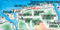
Location
- map: |
Baltrum is a sandy island
offshore of the mudflat coast of Lower Saxony and belongs to the
district of Aurich, federal state of Lower Saxony, Germany. |
|
Origin of name: |
Baltrum is first referred
to as ‘Balteringe’ in 1398, a name deriving from the Old Frisian for
‘grassland’, alternatively it refers to the ‘Settlement of Balter or
Baldur’. |
|
Relationship/similarities with other cultural entities: |
Frisian Islands, islands
of Lower Saxony, of the Netherlands, dune landscapes, mudflats,
national park of Lower Saxony, maritime landscapes and settlements. |
|
Characteristic elements and
ensembles: |
19th century houses
associated with the fishing industries. |

2. Geology and geography
2.1 General
The process which brought the islands into existence began about 10.000
years ago. Unlike the North Frisian Islands on the coast of Schleswig
Holstein and Denmark, the East Frisian Islands are not remnants of former
mainland. Instead they were created by deposition of sediments by the tide
and currents. These keep the water in constant movement, with the direction
of the current changes with the tides. These bodies of water carry
significant amounts of sand. In shallow water, when the carrying capacity of
the current lessens, the sand is deposited and the waves shape it into
barrier beaches and Platen (sandbanks) which are subsequently reinforced by
plant growth. The result is a sandy barrier island which, if unprotected,
gradually shifts position over the millennia, losing material on the seaward
side and depositing it on the leeward side. The eastern end of Baltrum was
approximately 4.5km to the west some 400 years ago (roughly located where
the eastern end of the island of Nordeney is now sited).
2.2 Present landscape
The settlement is concentrated in the western half of the island, and
comprises the villages of Westdorf and Ostdorf, which have practically
merged. The eastern half of the island is entirely natural, with sand dunes,
salt-marshes and tidal mud. The northern, North Sea face of the island
comprises a large beach, which widens to the east and is stabilised by
lengthy groynes to the west. The island elevation is 5m above sea-level.
3. Landscape and settlement history
3.1 Prehistoric and Medieval Times
Geologically speaking, the island is quite young. Even though there are some
prehistoric finds from the region of East Frisia there are no traces of
prehistoric activity on the present island. However, since the island has
repeatedly changed its shape and location over time any archaeological finds
would be buried beneath meters of sediment or in the sea.
The island is referred to in the chronicle which describes the effects of
the disastrous storm flood of 1362 (the Grote Mandrenke or Marcellus flood),
“and Baltrum a spade of sand, slipped out of a Giant’s hand, swept by wind
and waves”. Although there are no written sources for the earlier medieval
period in Baltrum, it is believed that the first permanent settlements on
the island were established during the 13th and 14th centuries. There is a
documentary reference to Baltrum as ‘Balteringe’ in 1398. It is known that
in the 1600s the western end of the was approximately 4.5km to the west,
roughly where the eastern end of Nordeney now stands. Nordeney was some
5.7km shorter than its present length in 1650. Any settlement on Baltrum
would have been very vulnerable to flooding events and would have severely
damaged, if not lost altogether, during the 1362 flood. As the island
shifted eastwards any settlement would also have had to move in that
direction.
3.2 Early Modern Times
Around 1700 there were some 1400 inhabitants on the island. However, because
of the storm floods in the 18th century, in particular the Christmas Flood
of 1717, the islanders were forced to move their townships and churches
further and further eastwards. In the 17th and early 18th century fishing
remained the primary economy of Baltrum. However, by the second half of the
18th century the marine trade industry had grown in importance. This had
become increasingly profitable by the mid-19th century, a fact that is
reflected in the surviving houses from that period with their souvenirs from
foreign lands, Delft tiles and ‘Buddelein’ (wall cabinets).
Baltrum was part of Prussia from 1744 to 1806. Following Napoleon’s defeat
of Prussia in 1806 Baltrum, together with the rest of East Frisia, became
part of the Kingdom of Holland. In 1866 Prussia annexed the Kingdom of
Hanover and the island again became Prussian.
In 1876 Baltrum became a sea side resort, although initially visitor numbers
were very low due to difficulties in accessing the island. In 1891 the
Baltrum town council ruled that all sea-bathing was only permitted with the
aid of a mobile beach cabin.
3.3 Modern Times
In 1925 Baltrum received an electricity supply and in 1935 a water supply.
The number of visitors increased greatly after the Second World War. To-day
the island has a permanent population of 600 and a visitor population of
3,500 in the summer months.
Developments catering for the visitor included a sea-water indoor swimming
pool and a miniature golf course as well as the ferry terminal.
4. Modern development and planning
The eastern half of Baltrum is part of the national park “Niedersächsisches
Wattenmeer”. This enables protection of the dunes, the saltmarsh, the beach
and the tidal flats. The national park is intended to preserve and protect
the special character of the nature and landscape of the dune and saltmarsh
region, including the typical appearance of the landscape. By this means the
course of the natural processes is supposed to be ensured and the biological
diversity is to be preserved.
4.1 Land use
The economy of the island was traditionally orientated towards the sea:
fishing and maritime trade. However, the economic structures of the island
are now dominated by tourism.
4.2 Settlement development
The settlement on the island is architecturally a resort settlement,
comprising a mixture of older resort buildings and more modern structures.
Red-brick and red tiled roves predominate. The tallest buildings are
4-storey. The settlement is concentrated in the western half of the island
in the villages of Westdorf and Ostdorf. There is very little in the way of
buildings on the remainder of the island.
4.3 Industry and energy
Traditionally the transport connection to Baltrum is by ferry from
Norddeich-Mole, near the German city of Norden. The status of the island as
part of the National park has affected all kinds of traffic on the island,
and vehicular traffic is subject to strict regulations.
4.4 Infrastructure
Water and electricity supplies were introduced to the island in the first
half of the 20th century.
5. Legal and spatial planning aspects
Baltrum belongs to the district of Aurich in the federal state of Lower
Saxony. In terms of land use planning the community of Baltrum is subject to
the regional planning of the federal state of Lower Saxony respectively of
the landscape framework plan and the land utilisation plan of the community.
Additionally, there is the regional planning concept for the coastal sea of
Lower Saxony. The territory of the community ends at the MThw line (line of
the Average High Tide). The coastal sea below the MThw line is „community-free
area“. Accordingly, the regional and building plan only applies to the land
but not to the sea area.
The present regional plans for the federal state of Lower Saxony (LROP)
contain only a few regional planning goals for the sea area. The area of the
national park is registered at the EU for the Fauna Flora Habitat guideline
(FFH) and therefore belongs to the biotope network system Natura 2000. The
main part of the park lies within the territory of the EU water withdrawal
guideline. In 1996 the Wadden Sea area within the borders of the national
park was recognised by the UNESCO as biosphere reservation in the context of
the program „Man and Biosphere“.
With regard to building regulations there are the NbauO and the
Baugesetzbuch (the German Statutory Code on Construction and Building), also
a Gestaltungssatzung (design statute) with its Gestaltungsfibel (design
primer) of 1995; a preservation statute; tourism statute; a statute for the
permission to subdivide land; various complementary statutes to ca. 15
land-use plans (inner, middle and outer area).
In the course of the village reformation these regulations are just being
reviewed.
6. Vulnerabilities
6.1 Settlement
The historic settlement pattern on Baltrum comprises the villages of
Westdorf and Ostdorf both of which are largely designed for the tourist
industry. The settlements are vulnerable to expansion and conversion within
the settlements.
6.2 Tourism
Tourism is the major economic factor on Baltrum and in itself provides both
potentials and threats to the Island. The expansion of Baltrum clearly is a
threat to any surviving archaeological deposits or surviving cultural
heritage features.
6.3 Industry and energy
The major reliance on tourism for the economy of the island could result in
the cultural heritage not being given appropriate protection in competition
with the development of the islands tourist infrastructure.
6.4 Natural processes
Because of its exposed maritime location and the characteristics of a sandy
island Baltrum is also threatened by natural forces. The sands in front of
the islands and at the beach are continuously moved eastwards by the surf
which rolls in mainly from the north-east. This dynamic island process is
affecting the landscape and, in the long run, the settlement structure.
7. Potentials
7.1 Tourism
Baltrum already has a thriving tourism industry and there is potential to
further promote the Cultural Heritage through the existing network of cycle
routes, walking routes etc.
7.2 Nature conservation
There is potential for the cultural heritage to be incorporated within
management plans for the nature conservation on the island. By creating
integrated management plans for both the natural and cultural environment
both elements can benefit.
8. Sources
Backhaus, H. (1943): Die ostfriesischen Inseln und ihre
Entwicklung: ein Beitrag zu den Problemen der Küstenbildung im südlichen
Nordseegebiet. Oldenburg
Buchwald, K., Rincke, G., Rudolph, K-U. (1985): Gutachtliche Stellungsnahme
zu den Umweltproblemen der Ostfriesischen Inseln: Schlussbericht. Hannover
Niemeier, G. (1972): Ostfriesische Inseln. Berlin
Petersen, J., Pott, R. (2005): Nordfriesische Inseln: Landschaft und
Vegetation im Wandel. Hannover
Pflüger, B. (1997): Gletscher- und Inlandeis in Polargebieten. Universität
Hamburg
Pott, R. (1995): Farbatlas Nordseeküste und Nordseeinsel: ausgewählte
Beispiele aus der südlichen Nordsee in geobotanischer Sicht. Stuttgart
Sindowski, K-H. (1973): Das ostfriesische Küstengebiet: Inseln, Watten und
Marschen. Berlin
Streif, H. (1990): Das ostfriesische Küstengebiet: Nordsee, Inseln, Watten
und Marschen. Berlin
Reports:
Merian (Heft 3/XXV), Ostfriesland und seine Inseln, Hoffmann und Campe
Verlag, Hamburg
Niedersächsisches Ministerium für den ländlichen Raum, Ernährung,
Landwirtschaft und Verbraucherschutz (2006) : Landes-Raumordungsprogramm
Niedersachsen, Ergänzung 2006, Hannover
Niedersächsisches Ministerium für Wirtschaft, Arbeit und Verkehr (2005):
Bericht der Landesregierung: Entwicklungen an der niedersächsischen Küste,
Hannover
Internet:
www.baltrum.de
www.niedersachsen.de
|