|
1. Overview
|
Name: |
Friesische Wehde |
|
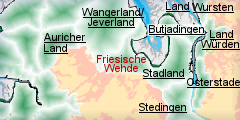
Delimitation: |
adebusen, the river Jade,
the river Wapel in the east and continental raised bog in the west,
neighbouring entity Land Ostfriesland, the north of the Friesische
Wehde borders on the river Bitze, and in the south on the neighbouring
entity Land Ammerland and its continental raised bog. |
|
Size: |
around 272
km² |
|
Location
- map: |
A rural district in the
south of Friesland, Nordsee, Jadebusen Lower Saxony, river Jade, river
Bitze, Wilhelmshaven, Germany |
|
Origin of name: |
‘Wehde’ derives from the
Frisian word for forest and indicates a formerly wooded area. |
|
Relationship/similarities with other cultural entities: |
Villages on dwelling
mounds, Frisian farmhouses called Gulfhaus, Geest ridge of Oldenburg
and East Frisia, slightly wavy Geest, marsh, scattered settlements
(Köttersiedlung), loosely grouped settlements near Büppel southeast of
Varel, brick works in Bockhorn |
|
Characteristic elements and
ensembles: |
Villages on dwelling
mounds, Frisian farmhouses (Gulfhaus), geest, marsh, scattered
settlements (Köttersiedlung), loosely grouped settlements, brick works
straight roads and paths, often running parallel to the dyke lines.
Single farmsteads and settlements are aligned along these roads and
paths. Neuenburger Urwald forest. Bronze Age boardwalk across the moor
between Büppel and Jethausen is of particular note Villages on dwelling
mounds, Frisian farmhouses called Gulfhaus, Geest ridge of Oldenburg
and East Frisia, slightly wavy Geest, marsh, scattered settlements
(Köttersiedlung), loosely grouped settlements near Büppel southeast of
Varel, brick works in Bockhorn |

2. Geology and geography
2.1 General
The Friesische Wehde consists of a 20-25 km long Geest and marsh strip and
one part of the Geest ridge of Oldenburg and East Frisia (Oldenburgisch-
Ostfriesische peninsula). The Friesische Wehde belongs to the administration
of the district of Frisia. Zetel, Bockhorn, Neuenburg and formerly Varel
belong respectively to the former communities of that name.
Contrary to the rest of the district, which lies mostly in the marsh, the
Friesische Wehnde lies on a Geest ridge which only borders the coast in a
few places and therefore offers a coast safe from flooding (e.g. at
Dangast). Because of its location between the rich Frisian marsh and the
Geest of Oldenburg, as well as the harbour of Varel, the Friesische Wehnde
always used to be a centre for trade. Neuenburg, for example, was built as a
border stronghold and possibly as a customs office between East Frisia and
Oldenburg.
The geomorphology of the region is dominated by two elements: the ground
moraine of the Geest of East Frisia and Oldenburg and the raised bogs in the
district of Frisia. An important feature in East Frisia and Frisia are the
Fehn channels, built for the transport of peat and the drainage of the
raised bogs. Ditches constructed chiefly for drainage in advance of peat
cutting are mainly found in the bordering moor regions.
The small towns of Horsten, Zetel, Bockhorn and Varel are concentrated on
the rim of a c. 15m high Geest ridge. Typical of the Friesische Wehnde are
the straight roads and paths, often running parallel to the dyke lines.
Single farmsteads and settlements are aligned along these roads and paths.
2.2 Present landscape
The Friesische Wehde lies between the raised bog complex of East Frisia and
the rivers Jade and Wapel. In the east of the region, the raised bogs of
Spolzener Moor and Basenmeersmoor are located, in the south west is the
Lengener Moor near Westerstede and in the south there are raised bogs on the
border with the Ammerland. The Friesische Wehde is characterised by the
contrast between the Geest and the marsh. Based on this, a landscape
developed which differs notably from the other Geest and marsh areas of
Lower Saxony.
The Geest landscape of Friesische Wehde occupies the southern third of the
district. The relief is slightly undulating and in the north east there is a
range of low hills which are dissected by streams and valleys. The Geest
ridges reach heights of 16.5m above sea level, the lowest valleys lie only
1.3m above sea level. In the valleys and in the transition zones close to
the marsh there are also fens and humid sandy valleys which are partly
interspersed with bands of marsh soils (e.g. in the region of the Zeteler
Tief).
The feature which makes the Geest of East Frisia and Oldenburg so unique is
the almost flat surface which ranges between 5 and 10 m above sea level and
shows a stronger relief in the area of the dune landscapes. Numerous small
rivers dissect the moraine plateau and characterise the landscape with its
alternating moor areas and the sandy, drift-covered, moraine ridges.
The name Wehde derives from the Frisian word for forest and indicates a
formerly wooded area. Today the letter “l”, derived from the noun “loh”
(forest/ woodland), at the end of place names still indicates a formerly
wooded area. Examples of such place names are Varel, Driefel or Ruttel. One
of the greatest natural monuments of the Friesische Wehde is the Neuenburger
Urwald (virgin forest of Neuenburg). It is all that remains of the formerly
great medieval Hudewald (or Hutewald).
3. Landscape and settlement history
3.1 Prehistoric and Medieval Times
After the last Ice Age storm tides changed the North Sea coast at the
present Jadebusen. To the north of today’s Jadebusen there used to be a
several kilometre-wide coastal marsh strip, which had been created by the
sea tides.
The most important morphologic process in all areas of the Geest was the
extensive surface erosion, this may have amounted to as much as 25 metres in
some areas. The post-glacial temperature rise and the melting of the inland
ice caused a rise of the sea level. But this was neither a steady nor a
constant development. Core samples from under the North Sea show that
transgression was not only interrupted, but sometimes was even regressive.
The exact date of prehistoric settlement of the Friesischen Wehde is based
only on indirect archaeological evidence. However, considering the wider
archaeological context, it can be assumed that the Friesische Wehde was also
part of local prehistoric and early historic developments. It can therefore
be concluded that by the beginning of the post-glacial period, today’s
southern North Sea coast was dry land and the areas of the river marshes and
Geest ridge were frequented by Mesolithic hunters-gatherers and their
predecessors.
Since about 4000 BC the region was settled by groups of farmers. This
process is evidenced by many prehistoric sites, e.g. at Neuenburg, Driefel
and Ruttel. The Neolithic marks the change from a natural landscape
influenced by a hunter-gatherer economy towards a cultural landscape
characterised by agriculture. The landscape development of the Geest was
largely influenced by this prehistoric land-use, with its extensive forest
clearance and the use of the resulting heathland. Important monuments dating
to this period include the cairn to the east of Bockhorn with its large
capstone and the barrows near Birkenfeld which are enclosed by stone
circles.
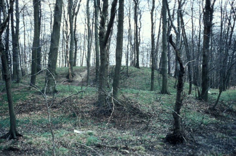
The succeeding Bronze and Iron Ages (about 1000 to 600 B.C.) are also well
represented by numerous sites like burial mounds and urn graves. The
excavation of the Bronze Age boardwalk (1356 B.C.) across the moor between
Büppel and Jethausen is of particular note, this seems to have provided a
connection between the Geest and a harbour place on the Jade.
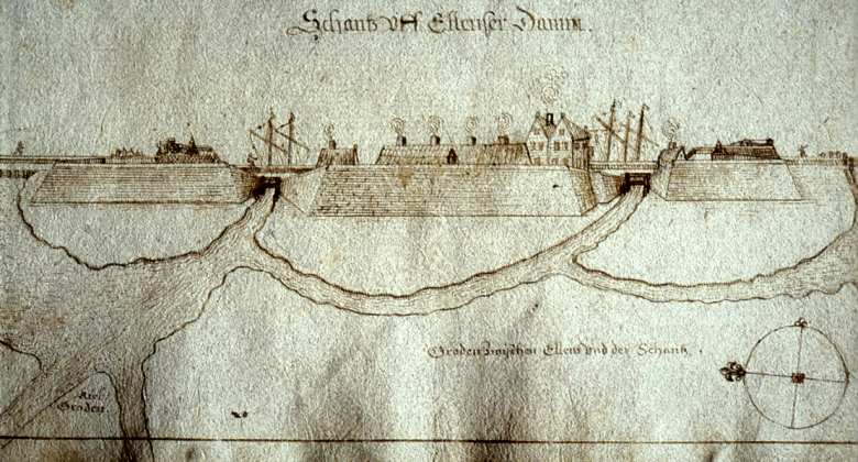 |
| Historic map of the entrenchment Ellener Damm |
The first farming settlements of Germanic tribes arrived around 250 A.D. in
the coastal area between the Ems and Elbe. Roman authors call these tribes
the Chaukes. Although it is known that these tribes in the Weser-Ems region
settled on dwelling mounds (Wurten), erected for protection against storm
tides, there are hardly any dwelling mounds documented for the area of the
Friesische Wehde.
There seem to have been dykes in the Friesische Wehde as early as the end of
the 11th century. Commentaries on the Deichfrieden (dyke peace) in the
“siebzehn Küren“ (seventeen elections), a manuscript of the Rüstinger laws
which dates back to the time of the Frisian freedom (12th to 14th century),
refer to them. Despite this early construction of dykes, the settled marsh
areas had to be abandoned due to rising levels of the storm tides (as with
the parish of Dangast flooded by the Marcellus tide of 1362). The flooded
areas and swamps became uninhabitable and the local population withdrew to
the Geest and the Geest edge. Resettlement of the parts of the lost marsh
areas only took place after dyke-construction in the years 1576 and 1578.
On the Geest edge are the small towns of Bockhorn, Zetel und Varrel, of
which Bockhorn and Zetel are mentioned in documents of 1220-1423 A.D. The
oldest buildings of these towns are the St. Martin Church in Bockhorn (1249
AD) and the St.Cosmas/Damian Church in Zetel which, in its present state,
dates back to 1344 AD. These typical Frisian churches are built of erratic
blocks of stone located on artificially built dwelling mounds.
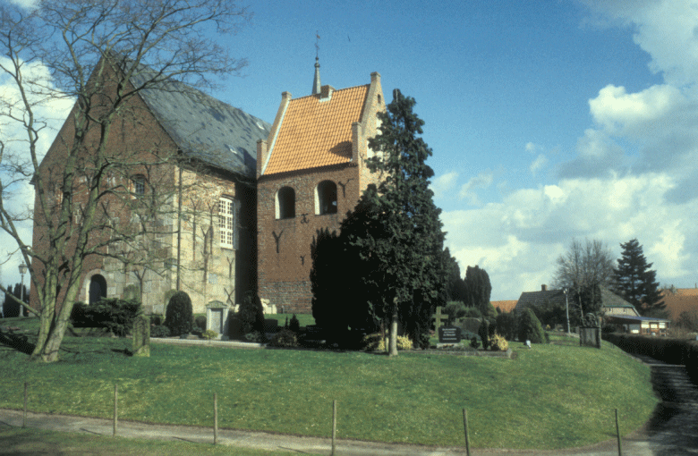 |
| Dwelling mound with church of the 15th century
of Zetel |
Near Varrel-Jeringhave the earthwork of the Jedutenhügel survives (probably
from a time between 512 – 1066 AD), its exact age and function are still
unclear, it might have been a land mark or the site of a court.
In the vicinity of today’s Geest settlements, medieval Eschböden survive,
these were created by the laying down of grass or heath sods that had been
previously laid down in the stables, in order to fertilise the depleted
sandy soils. The sod cutting led to an increase in the amount of heath in
the Geest. The heaths and raised bogs which developed were used as extensive
pasture. Since medieval times these areas were colonised by Kötters, they
usually lived in scattered or loosely-knit settlements. Examples of these
Kötter settlements, which were built in loose rows, include the village of
Büppel (founded about 1570 A.D.) south-east of Varrel and the nearby
villages of Neuenwege and Rosenberge.
Because of timber-logging in the extensive deciduous woodlands, the
Friesische Wehde had already gained economic importance by the second half
of the 14th century. For this reason the Counts of Oldenburg tried to regain
their old sovereign rights, which they had lost during conflicts with the
Frisian chieftains in the area of the Friesische Wehde. A particular
cultural monument from this time is the Neuenberger castle which was built
in 1462 by the Count Gerd zu Oldenberg as a stronghold against the East
Frisians. When the Friesische Wehde became part of the Oldenburg is not
recorded, but it can be assumed that it happened by 1480. However, the
territorial administration for parts of the Friesische Wehnde is only
officially documented since the time of the Peace of Zetel in 1517. These
documents clearly state that Count Johann was granted the villages of Zetel
and Driefel with their associated territories.
 |
| Remains of the castle with moat nearby Bockhorn |
3.2 Early Modern Times
During the Thirty Years’ War the Count of Oldenburg, Anton Günther, enlisted
Danish auxiliary troops. The country was mostly spared pillage but the
overall situation of the region only improved after the peace treaty in
1648. With the death of Count Anton Günther in 1667 the counties, including
the Friesische Wehde, fell to the King of Denmark and the Duke of
Holstein-Gottrop until 1773. After changing regencies, Oldenburg, which
(under Count Peter Friedrich Ludwig of Oldenburg) had advanced to be a Grand
Duchy, regained the sovereign rights.
The economy of the Friesische Wehde in those times was characterised by
agriculture, with the addition of timber-logging, peat-cutting and
clay-works. A striking feature is the small forest stand of the
Oldenburgische Vogtei (1790-1799). The forest had been severely decimated
because of extensive and lasting de-forestation for the building of dykes
and strongholds as well as due to agricultural over-exploitation of the
mixed forest economy (grazing, cutting foliage to use as litter and sod
cutting).
Towards the end of the 18th century several settlements developed along
Tiefs (drainage channels) and sluices. These included numerous businesses,
trading houses, brick works and home weaving. This development became
possible not only because of the population increase but also because of the
profits made in agriculture which were available for investment.
The regional development of the Friesische Wehde also benefited from rich
clay deposits of an unusually high quality. These clay deposits consist of a
kind of yellow-banded clay which is mined in a depth of one to two metres
(Bockhorner Klinker) and the Lauenburger clay which is mined down to a depth
of 100 metres (red bricks). At the end of the 18th century the first
commercial brickworks developed on these clay deposits. This industry was
aided by the construction of brick roads in the early 19th century in the
course of the development of the local public infrastructure. The production
of the last hand-made bricks only ended in 1914, whilst the industrial brick
production still forms an important economic feature of the Friesische
Wehde.
A good example for this is the business association Vereinigte
Oldenburgische Klinkerwerke GmbH which was founded in 1908 and is still
sited in Bockhorn. The demand for bricks continually increased over the
years and the name of Bockhorn became known all over Europe.
3.3 Modern Times
During the time of the French administration (1807 till 1814) the population
as well as the trade in the Friesische Wehde suffered under the reformations
and restrictions. Under the influence of the French-dominated Kingdom of
Westphalia, the feudal system was abolished in 1808 and a communal
constitution, as well as a new legal system, was introduced. During this
time the Friesische Wehde consisted of the Canton Varel with the Mairien
(parishes) of Bockhorn, Neuenburg, Varel and Zetel. After 1814 these
reformations were revoked and the Grand Duchy of Oldenburg introduced new
administrative rules and created new community structures and offices. This
lead to the foundation of numerous new settlements and was accompanied by a
systematic drainage which allowed an intensive cultivation of the moor
areas.
Since the 18th century home-weaving developed mainly in Zetel (Zeteler
Leinen) but also in Bockhorn and Varel. The necessary flax was cultivated in
the Friesische Wehde but also in the fertile marshes. During the 19th
century an impressive upturn of the industry took place in the Friesische
Wehde. Since the 1920s the cloth-weavers came under pressure because of the
cheap cotton products from England.
Clothing factories developed alongside the weaving mills at the end of the
19th and the beginning of the 20th century. Following the 1950s the cotton
and cloth weaving mills declined and had nearly vanished by the end of the
century. The brick works on the other hand are booming. The demand for
bricks increased with every year and the brick industry made the name of
Bockhorn known all over Europe.
4. Modern development and planning
4.1 Land use
Unlike northern Frisia, the Friesische Wehde consists of a densely wooded
region which is also characterised by Geest and moor areas which are used
for agriculture and as pasture.
Agriculture still plays an important role in the economic output of the
region but has lost ground to the service sector. The share of manufacturing
industries has declined by 18%, whilst the share of the private and public
services sector has increased significantly. This progress is demonstrated
by the influence of the structural change on the industrial concentration
which has declined by 50%. However, the region has coped well with
structural change as can be seen in the continual population increase during
the last 15 years. But even though the indebtedness of region of the
Friesische Wehde (especially Zetel) it lies below the national average, the
unemployment rate is above the national average.
Forestry has ceased to be an important employer in the Friesische Wehde,
partly because the forests have almost vanished due to intensive usage and
partly because the remaining forest areas (e.g. the Neuenburger virgin
forest) are placed under protection.
Today this area is used by tourism. The district administration is banking
on a further development of tourism in the natural and cultural landscapes
of the Friesische Wehde, e.g. in the moors and marshes or Geest landscapes.
To encourage and feed the tourist interest in the unique culture of this
region it is necessary to preserve the historic agricultural and
technological structures (field structures, drainage ditches) and buildings,
as well as historic settlements and their special characteristics.
A widespread system of hedges on banks of great cultural historic importance
provide additional structural variety and fulfil important roles in the
landscape. The lower parts of the Friesische Wehde are characterised by
grassland and notable waterways. There are also some beech groves which form
valuable small habitats. The areas of the Geest borders are also
characterised by grassland but mostly used on a more intensive scale.
4.2 Settlement development
With a size of 608 km² the district of Frisia, to which belongs the
Friesische Wehnde, is the smallest of the districts in the Oldenburger Land.
On the other hand it has the highest population density with 162 people per
square kilometre.
The main settlement emphasis in the Friesische Wehde lies in the small towns
of Varel, Zetel, Bockhorn and Neuenburg in the south. As a consequence most
of the infrastructural facilities are concentrated in these areas. The
diversity of the district of Frisia is shown not only in its landscape, but
also in its cultural life. To preserve this diversity the Wadden Sea
National Park was founded, this protects the salt marshes and tidal flats
but is still open to tourism as a recreational area. Together with
agriculture, trade and industry, tourism has developed significantly over
the last few years. The tourist bureau of the district of Frisia counted
3.44 million booked overnight stays during the year of 2004. The officially
recognised climatic spa of Neuenburg registers many thousands of overnight
stays per year and lives mainly on tourism. The visitors of the Friesische
Whede are attracted not only to the close proximity of the North Sea but
also to the wide marsh and moor landscapes (e.g. Bockhorner Moor) and the
natural monument of the Neuenburger virgin forest.
The community of Zetel on the other hand does not depend as much on tourism
as many other holiday resorts but nevertheless it also contains some sights
like the church of Zetel and the North-West German School Museum. In the
community of Varel there is the regional museum and the palace chapel of
Varel which is one of the oldest buildings of the town. The first historic
mentioning of the building of this church dates back to 1144; the richly
furnished inside of the church is especially worth seeing.
4.3 Industry and energy
The Friesische Wehde is an economically rather poorly-developed region, but
it is characterised by a large number of small and medium-sized businesses
and sited close to several big industrial sites. Numerous industrial
enterprises are based in the neighbouring towns of Wilhelmshaven, Rastede
and Oldenburg. Then there is the brickworks of the Röben-Gruppe in
Schweinebrück, one of the most important employers of the Friesische Wehde.
Other important employers are the forwarding companies in Zetel,
Schweinebrück and Collstede. During the last ten years vigorous efforts were
made to create new jobs in the area of the Friesische Wehde. To this effect
two medium-sized industrial parks were created in Driefel and Collstede.
The Bundesstatistikamt (Federal Office for Statistics) and the Institute for
Economic Research of Lower Saxony prognosticate a population and employment
increase for the region due to the planed schemes. These schemes relate to
the expansion of the harbour of Wilhelmshaven, the extension of the wind
farm in Varel as well as an expansion of the aircraft construction sites of
Varel and Nordenham and the planed extension of the Hinterland connections.
4.4 Infrastructure
The Autobahn A 29 leads in the east of the area of the Friesische Wehde from
north to south from Wilhelmshaven via Oldenburg to the Autobahn junction
Ahlhorner Heide where it meets the A 1. This connection links the area to
the national network of trunk roads. There is also the B 437 which runs
through Bockhorn and Neuenburg from Friedeburg over Varel to the newly-built
Weser- tunnel. On working days there are busses commuting almost every hour
from Zetel to Varel, Wilhelmshaven and Westerstede. The railroad traffic in
the Friesische Wehde can be called meagre at best. Public railroad transport
only services the line Wilhelmshaven-Sande-Varel-Oldenburg-Osnabrück on a
regular basis.
An important step towards improvement in the local traffic network would be
the construction of the planned coastal motorway A22 which is going to lead
from the Elbe crossing at Stade through the new Weser-tunnel near
Rodenkirchen to the A 28 at Westerstede. It is going to pass the small towns
of Varrel, Bockhornerfeld and Altjürden and meet the Autobahn A 29 at
junction 10.
5. Legal and spatial planning aspects
The district of Frisia, and therefore the Friesische Wehde, lies east of the
historic landscape of East Frisia. The differentiation of the names Frisia
and East Frisia can be explained by the fact that this area belonged
historically to the old Frisia but never was part of the county of East
Frisia but of Oldenburg.
The Friesische Wehde consisted of the communities of Bockhorn and Zetel
until in 1867 the community of Neuenburg was founded. In 1933 Bockhorn,
Neuenburg and Zetel were combined and became the large community Friesische
Wehde with its seat in Bockhorn. Together with the Council of Varel it
became the newly-created district of Frisia but in 1948 the three old
parishes were re-established.
In the course of the new regional and administration reformation (1972) in
Lower Saxony the communities of Varel and Neuenburg lost their status as
independent communities and were integrated into the large community
Friesischen Wehde. The Friesische Whende in turn was integrated in the
district of Ammerland when the district of Frisia was disintegrated. This
process was again revoked in 1979.
With regard to land use planning the communities of the Friesische Wehde are
subject to the regional planning program of Lower Saxony respectively to the
landscape framework plans and land use plans of the communities. Furthermore
the regional development concept for Wilhelmshaven and the regional planning
concept for the coastal sea of Lower Saxony have to be taken into account.
The communities of the Friesische Wehde of Lower Saxony belong to the
regional authority of Frisia.
6. Vulnerabilities
6.1 Settlement
The changing land use could endanger the unique cultural and natural
landscape of the Friesische Wehde with its moors, hedges on banks, woodland
biotopes as well as the Geest and the historic cultivated village structures
and buildings. The expansion of tourism will put pressure on historic
villages to expand.
6.2 Agriculture
For agriculture to adjust in its production quantities to the pressure
of increasing competition of cheap foreign imports an extension of the
productive areas is going to be necessary. This could result in a landscape
characterised by mono-cultures which would remodel the typical landscape
structures. In the future a changing land use planning affected by economic
development impulses could have a negative influence on the historical
landscape Friesische Wehde.
6.3 Tourism
There is increasing pressure across the area for a further development
and enlargement of the tourist industry.
6.4 Industry and energy
The planned construction of a container deep water harbour in
Wilhelmshaven (Jade-Weser-Port) will have an impact on its regional
surroundings, including the Friesische Wehde.
6.5 Infrastructure
In regard to the increasing globalisation and the deep water harbour an
industrial park (Jade Weser Park) is planned which will lead to the need to
expand the infrastructure of the area. The increasing flow of goods is
mirrored by a demand for efficient reloading points which in turn could
cause a development of land and the establishment of businesses and
employers. In this context some aspects have to be seen in a negative light:
new settlements which are not integrated into the landscapes, larger
industrial plants and commercial areas ruining the landscape as well as the
additional strain caused by the expansion of the road networks, e.g. of the
A 29 or the coastal motorway A 22. The improved accessibility of the
Hinterland could cause a loss of Identity in the traditional means of living
and local culture due to increasing commuting, new settlers with foreign
background (regional as well as cultural) and mass tourism.
7. Potentials
7.1 Spatial planning
It is essential for the preservation of the historic cultural landscape
of the Friesische Wehde that the major development such as at Jade-Weser
Port and its associated infrastructure include the cultural heritage as an
integrated part of the planning process. There is the potential to both
protect and promote the cultural heritage within the spatial planning of the
region if it can be integrated at an early stage.
A development concept has been issued by the Niedersächsischen Institut für
Wirtschaftsforschung (NIW) (Institute for Economic Research of Lower Saxony)
with special regard to the expected regional economic effects of the
Jade-Weser Port on the town of Wilhelmshaven and its associated region. This
concept is of great economic importance for the region of Wilhelmshaven. It
encompasses not only the actual harbour extension but also the expansion of
the infrastructure and the Hinterland connections as well as the development
of a business park (Jade Weser Park). The area Friesische Wehde shows great
potential especially in the field of maritime economy and also the fields of
air and space industry seem promising, as can be seen in the Airbus plants
in Varel and Nordenham. Therefore the quality of the infrastructure between
the different sites is gaining importance for the regional economic
development. In this context a coastal motorway like the planned A 22 would
be advantageous. It would provide a more speedy connection of the coastal
sites, better integration of the industrial plants into the Hinterland and
increase the number of short break tourists and commuters. This concept
provides great potential if the cultural heritage can be clearly integrated
with the proposals.
7.2 Settlement
In many places, e.g. in the small town of Büpel near Varel, in Neuenwege
and Rosenberge, the old settlement patterns and structures (Köttersiedlung)
are still visible and provide the potential to promote the cultural history
of the area. Careful integration of the cultural heritage into planning
proposals is essential to retain the layout and ambience of the settlements.
There are also many cultural and landscape monuments like the Neuenburger
Schloss, the churches of Zetel and Bockhorn, the Jeduten hill, and the
Frisian castle hills.
7.3 Agriculture
The Friesische Wehde has preserved its charm of a cultural historic,
agriculturally used landscape. Characteristic for the cultivation process of
the Geest sites are the Eschböden which were created by a sod-cutting
economy. This agricultural practice only ceased with the introduction of
mineral fertiliser. Much of the historic field pattern survives with many
hedges and trees on banks which is rare and provides the potential to
preserve and promote the historic farming method.
7.4 Tourism
The importance of the region for tourism should be seen as a catalyst
for the enhancement for other sectors of the comparatively economically
underdeveloped region. Various cultural programs can be promoted, including
events and exhibitions about the cultural monuments of the Jade-Weser
region. Institutions dealing with the subject of (cultural) landscape are:
The Coastal Museum in Wilhelmshaven, the regional museums in Varel and
Friedeburg, the castle Neuenburg, the State Museum for Art and Cultural
History of Oldenburg, the city museums of Oldenburg, the State Museum for
Nature and Man of Oldenburg and the windmill in Varel. These institutions
promote the cultural identity of the region and also present the results of
the latest research in their exhibitions. There is the potential to promote
cultural tourist routes either via car, bicycle or walking via these
centres.
7.5 Natural environment
The Friesische Wehde shows a high structural diversity. Especially worth
mentioning in this context are the protected Neuenburger virgin forest with
its up to 800-year-old oaks, the Geest and moor areas which are used as
fields and pasture as well as the marsh areas in the north and the salt
marshes in the proximity of the North Sea coast (Jadebusen).
8. Sources
Author: Nils Schilke
Brune, Werner (Hrsg): Wilhelmshavener Heimatlexikon in 3 Bänden 1986-1987
Bundesamt für Bauwesen und Raumordnungen (BBR) (Hrsg.) : Raumordnungsbericht
2005. Bonn
Jung, Hans-Ulrich, Pohl, Martha & Weber, Kai (Hrsg.): Wirtschaftliche
Entwicklungsperspektiven des Jade-Weser-Raums unter besonderer
Berücksichtigung des geplanten Jade-Weser-Port/ Regionalwirtschaftliche
Auswirkungen u. Handlungsnotwendigkeiten f. d. Stadt Wilhelmshaven u. d.
Landkreise Friesland, Wesermarsch. Hannover, 2001. Bremen
Meyer, Georg (Hrsg.): Die Geschichte der Friesischen Wehde in 2 Bänden 1910,
Reprint der Original-Ausgabe 1995
Niedersachsen / Landesamt für Bodenforschung (hrsg.): Geologische Karte von
Niedersachsen : Bundesrepublik Deutschland, 1958. Hannover
Niedersachsen / Landesverwaltungsamt; Institut für Denkmalpflege(Hrsg):
Archäologische Denkmale und Fundstellen in Niedersachsen, Aufsatzsammlung:
Archäologische Denkmale im Landkreis Friesland / [Text: F. W. Wulf] ,
Niedersächs. Landesverwaltungsamt1986. Hannover
Schäfer, Rolf (Hrsg): Oldenburgische Kirchengeschichte erw. Aufl. 2005.
Oldenburg Isensee
Schmidt, Heinrich (Hrsg.): Mittelalterliche Kirchengeschichte / Heinrich
Schmidt. – 2005. Oldenburg.
Schmidt, Heinrich (Hrsg): Ostfriesische Landschaft; Ostfriesland und
Friesland / Geschichte / Aufsatzsammlung; Lengen, Hajo van, Ostfriesland /
Aufsatzsammlung, Ostfriesische Landschaftliche Verl.- und Vertriebsges.,
2005. Aurich
Wulf, F.- W.: Übersichtskarte der geschützten Landschaftsteile sowie der ur-
frühgeschichtlichen Funde / F.-W. Wulf . - 1994.Hannover
Internet sources
Niedersächsisches Landesamt für Straßenbau
www.kuestenautobahn.info/55.173.0.0.1.0.phtml
|