|
1. Overview
|
Name: |
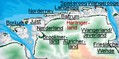
Harlingerland |
|
Delimitation: |
North Sea with the
islands Langeoog and Spiekeroog, Geest border, neighbouring entities
Norderland, Auricher Land, Wangerland |
|
Size: |
Approx. 657 km² (administrative district Wittmund) |
|
Location
- map: |
Sea marsh in the western
part of Lower Saxony, Germany |
|
Origin of name: |
Wangerland is a
historical name which can be traced back about 1200 years to the
Friesian Gau Wanga. The name Wangerland is derived from the Friesian
Wanga, a pasture or plain. The earliest mention of the name (in two
different sources) was in 787 AD. The Wanga is mentioned in the
chronicles of Moissac Abbey in southern France, and also in the Vita
of Saint Willehad. |
|
Relationship/similarities with other cultural entities: |
Similar Heritage and
cultural landscape to Norderland and parts of Wangerland/Jeverland.
Shares tourist activities with both the mainland and island coastal
resorts. Used similar sod techniques on the Geest similarly to other
Geest areas such as Auricherland. |
|
Characteristic elements and
ensembles: |
Dwelling mound landscape
with its large village mounds and massive farmhouses. The maritime
heritage significant of coastal regions is reflected by dykes and
floodgates as well as by sluice harbours. Lake marsh, Geest, peatland
areas, tourism, agriculture rural house forms with Frisian
gulf-houses, loose scattered villages, sluices, linear settlements and
settlements on dykes. |

2. Geology and geography
2.1 General
The cultural entity of Harlinger Land stretches across the whole northern
part of the East Frisian administrative district of Wittmund as well as
across both the islands of Spiekeroog and Langeoog. Nowadays the area is
known as the administrative district of Wittmund Harlinger Land.
In the north it reaches the coast, whose offshore mud flats belong to the
Wadden Sea National Park of Lower Saxony. The origin of the East Frisian
Islands goes back to sand banks, uncovered at high tide, which formed around
the time of Christ’s Birth, on which sand dunes developed. The islands are
mobile and have changed their position and size numerous times over the
centuries. They would still do this today if the sea defences were removed.
The edge of the marsh consists of deposits from two former bays: to the west
the bay of Durnumersiel and to the east the Harlebucht (Harle Bay). In the
south the Harlingerland covers the northernmost outcrop of the East
Frisian-Oldenburg Geest. Off this was the large Geest-island of Esens with a
marsh fringe to the north, in which there are a number of smaller
Geest-islands.
The bay of Donumersiel was created by the flooding of an Ice Age meltwater
valley. Around 5000 BC, the sea reached the present coast of East Frisia and
flooded the valley of Dornumersiel. In the high Middle Ages storm floods
broke into the area of Dornum-Westeraccum and to the south of it. Between
Bensersiel and Neuharlingersiel an approximately two kilometre broad piece
of the coast has disappeared since medieval times. The village of Otzum was
left outside the dykes in 1420; its remains – especially those of the church
– can still be seen in the mud flats. In 1570 the dykes around the villages
of Westbense and Ostbense were completely destroyed. Harlebucht (Harle Bay)
forms the eastern part of the Harlinger Land. It originated in big land
losses due to storm floods in the high Middle Ages and reached from
Neuharlingersiel in the west to Friederikensiel in the east, with its four
side bays of Esens, Burhafe, Wittmund and Sandel. From about 1400 dykes were
built in the bay and land reclamation began.
2.2 Present landscape
Most of the landscape is characterised by the sea marshes of Dornumer Bucht
(Dornum Bay) and Harlebucht (Harle Bay). The East Frisian Islands are marked
by their dune-landscapes and tourist facilities. The healthy sea climate
with its clear, salty air, moderate changes in temperature and long
durations of sunshine have made them an important area for leisure
activities. Modern spas and seaside resorts have developed out of fishing
villages on the coast.
 |
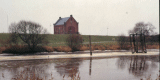
 |
| Dyke nearby Harlesiel ©
Fuchs,
NLD |
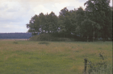
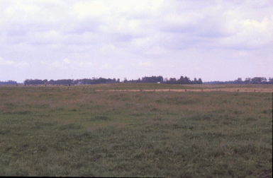
Historic landscape with mounds nearby Leerhafe ©
Fuchs,
NLD |
On the Geest, as well as on its northerly boundary, there are extensive
raised bogs. Here the peatlands of Meerhusener Moor and Tannenhausener Moor
as well as the nature reserve area Ewiges Meer form important landscape
components.
Within the Geest-area varied groupings of arable- and meadowland, trees and
embankment hedges, secluded farmyards and villages are evident today.
Villages and farmyard groupings on large mounds (settlement mounds) as well
as small, flat dwelling mounds with farms contribute to the unmistakeable
character of the landscape. With its great variety in natural areas the
Harlinger Land represents every type of landscape present in the Lower
Saxony’s coastal-region.
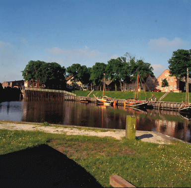 |
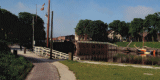
 |
| Panorama of the sluice harbor Carolinensiel ©
Fuchs,
NLD |
Panorama of the sluice harbor Carolinensiel ©
Fuchs,
NLD |
3. Landscape and settlement history
The Harlingerland has a complex and fluid settlement history. In the marsh
in particular, man’s continual struggle to gain and preserve land can still
be observed well in the characteristic dykes and dwelling mounds.
3.1 Prehistoric and Medieval Times
Large-scale investigation of the North German mud flats and on the adjacent
Geest has progressed considerably, due to the efforts of the Institute of
Historical Coastal Research and of municipal, regional and local
archaeologists. As a relatively recent geological area, the Weser-Ems area
is marked by quaternary deposits. The tidal river marshes of the
Harlingerland have been formed since the end of the last Ice Age.
The exact date when the Harlingerland was settled can only be determined by
comparison with neighbouring areas, and by assuming that the same trends and
developments occurred in the Harlingerland. At the beginning of the post-Ice
Age period, today’s southern North Sea coast was dry land and the North Sea
coast itself was located in the area of the Dogger Bank. It can be presumed
that Harlingerland was frequented up to the Mesolithic by foragers. It is
entirely possible that sites belonging to these or later phases are located
beneath the marsh and its layer of sediment deposits.
The Geest was settled by farmers in the Neolithic Age, c. 4000 BC.
Monumental evidence for this period included the megalithic grave sited on a
Geest-ridge near Utarp, unfortunately the above ground remains of this have
been utterly destroyed. Numerous finds attest to peoples inclusion of the
peatlands of the region within their land use. For the Middle and Late
Bronze Age, roughly between 1500 and 1000 BC, there was a phase of
sea-withdrawal. A few archaeological finds show that those people living on
the coast reacted to the changing ecological conditions and settled in the
marshy regions. The Geest was relatively densely settled during the Bronze
Age, as the number of graves dating to that period demonstrate. A fine
example is the “Radbodsberg” near Dunum, where the Frisian king Radbod is
supposed to have been buried. Before excavation the mound still had a
diameter of 25 to 30 metres and was regarded as the biggest tumulus in East
Frisia. The primary burial dated to the late Neolithic period. In the Early
Iron Age it was used for further burials. Remains of Late Bronze Age
settlements were discovered when the topsoil was removed prior to
development in Brill and Westerholt.
This settlement period of prehistory ended around 300 BC, when the sea once
again advanced. Archaeological finds in the mud flats off Ostbense and the
dating by dendrochronology to 210 BC of wood from a number of excavated
houses from that site, has raised the issue as to whether there was really a
complete abandonment of the sea marshes at that time. Between 150 and 50 BC
another withdrawal of the sea led to a new settling-period, which did not
end this time when the sea penetrated yet again in the 1st century AD.
Instead the people living on the coast started building dwelling mounds (settlement
mounds), that is symmetrical mounds consisting of dung and clay on which the
dwelling place was sited. Archaeological finds from today’s mud flats off
Ostbense give proof of the changed coast line. Remains of such a settlement
mound, dating to the 1st to the 4/5th centuries AD was documented here. In
addition burials of the 5th century provide evidence for the existence of
former settlement areas, which probably sank in the early Middle Ages.
Excavations of a settlement in Westerholt, in the immediate vicinity of the
marsh, provide insights into the life and the activities of the 4/5th
century on the northerly Geest border. Here farmhouses, outhouses and
leftovers from iron-processing were discovered.
In the 5th century a thinning of population started in the north of Germany.
According to new research, a withdrawal of the North Sea did not take place
between 350 and 700 AD, so ecological reasons cannot have been the reason
for this population reduction. A few ceramic finds, for example from
Ostochtersum, demonstrate that there was not a complete lack of settlement.
Stronger settlement activity began in the 7th century AD.
The next settlement of the marsh is ascribed to the Frisians, who expanded
from their tribal-area in the Netherlands. In comparison to the situation on
the coast, the high Geest was probably only thinly settled. This situation
changed in the 6/7th century AD due to a long-term extension of land (not
clear what is meant here). The oldest remains found to date on a Geest
settlement, have been excavated close to Esens. Six houses with byres, which
existed one after the other, have been recorded The settlement began in the
6th century. The large burial ground of Dunum gives an even better idea of
the situation. Here 778 burials from the late 7th to the 10th century were
uncovered. The inventory of the Frisian burial ground provides information
about the local- and long-distance trading which was across the North Sea to
England and across the Balti to Scandinavia.
About 300 mounds (settlement mounds) are known on the North Sea coast, of
which roughly 220 are farmyard-mounds, 33 village-mounds and 18
church-mounds. These were subsequently surrounded by dykes. In western
Harlingerland there are a number of village-mounds, and in the marshland
close to the coast reaching as far as Ostbense there are a number of small
mounds. Whilst the village- and church-mounds lie close to the Geest, the
majority of the farm-mounds are sited in the outlying marsh, mainly in the
Harle Bay. On the western shore there are such mounds as: Gross Holum,
Werdum with the smaller secondary mound of Berdum, Eggelingen, Toquard and
the village-mound of Funnix. On the Geest-islands further dwelling mounds
exist. With the aid of place name-research it can be inferred that they were
expansion-villages of the late Middle Ages. A number of farmyard-mounds
along the older secondary-dykes makes up small settlements. However without
appropriate investigations the precise dating of these settlements is often
virtually impossible.
In the 11th century the mounds of Funnix, Werdum and Egglingen were
protected by ring-dykes for the first time, which were primarily to protect
the settlements and the working areas in the vicinity from high tides. In
the high and late Middle Ages the first closed dyke-lines following sea-side
embankments were constructed, as at the Funnixer Altdeich or Berdumer
Altdeich (Old Dyke). The marsh was drained both by natural and artificial (Harle)
watercourses, which still run through the countryside. Sluices in the
outer-dykes, the so-called floodgates, have regulated the flow of water
since the 15th century. In the Seriem mud flats a floodgate was partially
uncovered, which was dated post-1464 by means of dendrochronology. It
presumably belongs to the western end of Harlebucht (Harle Bay) or to or a
withdrawal dyke which was set up after the village of Otzum was excluded
from the protection of the dyke in 1420.
In the high and late Middle Ages a number of castles and fortified mansions
were built, which still exist in Berdum, Butforde, Esens, Funnix, Seriem,
Utarp, Werdum and Wittmund.
Since the high Middle Ages the living conditions on the Geest had stabilised
due to new agricultural techniques. The use of the sod-technique of
fertilising in combination with the cultivation of winter rye provided
increased returns and incidentally the burying of archaeological evidence.
The monasteries of Marienkamp and Schoo, founded in the late Middle Ages,
have left no significant traces. Today an artificial fish-pond is the only
remnant of the monastery of Schoo (today Domäne Schoo nearby Esens).
3.2 Early Modern Times
In the 15th century the setting up of dykes began around Harlebucht (Harle
Bay), which had been breached by storm floods in the early Middle Ages. The
building of dykes began on the western edge. Between 1500 and 1550 a dyke
which began in Altfunnixsiel, ran past the site of the future
Altharlingersiel and reached the coast at Neuharlingersiel, founded in
1693.The Berdumer Altdeich (Old Dyke) was built in the centre in 1570 and
the old middle dyke of Berdum, which had been built in 1598, moved. In 1617
dykes were built on the Werdumer Altengroden. In combination with the
foundation of Neufunnixsiel in 1658, the new middle-dyke of Berdum was built.
In the 17th century further dykes were built. In 1729 the harbour of
Carolinensiel was founded. In 1765 the Friedrichsschleuse was developed in
front of Friedrichsgroden. Up to 1895 the places Schwerins-, Neu-Augusten-
and the Elisabethgroden were added. With the foundation of the
sluice-harbour of Harlesiel in 1956 the building of dykes around Harlebucht
(Harle Bay) ended.
Political rule by chieftains in East Frisia developed in this period. After
the chieftain Sibet Attena had united Esens, Wittmund and Stedesdorf in
1454/55, the united Harlingerland kept its independence for a while. Battles
with the Cirksena, the lords of East Frisia, took place. From 1600, after
much back and forth, Harlingerland belonged to East Frisia. In 1744 all the
Cirksena possessions, including the Harlingerland, were taken over by the
Prussian kingdom.
 |
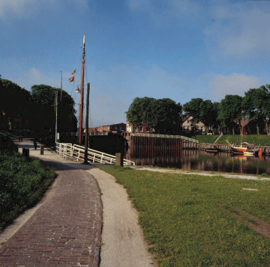
 |
| Panorama of view of the ancient dyke of
Carolinensiel ©
Fuchs,
NLD |
|
The Harlingerland did not have any characteristic sea-trading places rooted
in the Middle Ages, such as Emden. Only two trading places with a typical
structure developed, at Esens and Witmund. Here the centre is built around a
church mound, with a square serving as a market in front of it and a long
street with urban houses. Esens received town-rights around 1500 and in the
late Middle Ages was the capital of Harlingerland. In 1744 the Prussians
transferred the essential functions such as the mint to Aurich and Esens
degenerated into a provincial town. Finally in 1806 the Prussians designated
Wittmund as the district city of the Harlingerland enlarged by the district
of Friedeburg.
At the watergates the small harbour-settlements typical of the Harlingerland
developed, as at Carolinensiel, whose heyday was in the mid 18th century.
With the appearance of steamboats at the beginning of the 20th century,
however, its era came to an end.
 |
 |
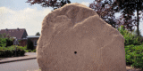
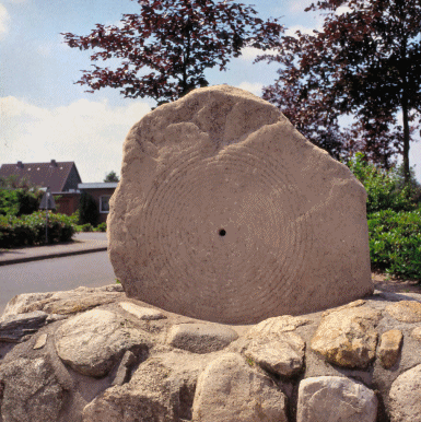
|
The so called „Sun stone“ (Sonnenstein), a bronze age
finding, situated at Horsten ©
Fuchs,
NLD |
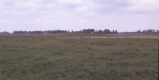
Historic landscape with mounds
nearby Wittmund ©
Fuchs,
NLD |
3.3 Modern Times
The administrative district of Wittmund emerged from the districts of
Wittmund and Esens as well as the town of Esens. Within the scope of
district reform of 1977 in Lower Saxony, the administrative district of
Wittmund was dissolved and fused with the communities of Jever Sande,
Schortens, Wangerland, Wangerooge into a new administrative district of
Friesland. After a complaint about infringement of the constitution at the
constitutional court of Lower Saxony in Bückeburg, the administrative reform
was changed once more and the administrative district of Wittmund was
restored to its present form.
The economy of the Harlingerland is traditionally characterised by
agriculture, and today by tourism. Seen from an industrial and trade
point-of-view there are a number of medium-sized companies and family run
businesses.
Wittmund consists of unified communities such as Langeoog, Spiekeroog,
Friedeburg and the town of Wittmund as well as the administrative units of
Esens and Holtriem. Wittmund as district town and the seat of administration
is the largest town with more than 21.000 inhabitants, followed by Esens
with roughly 7.000 inhabitants. Esens is a small town with a distinct
tourist infrastructure which, however, has also got extensive industrial
estates and a newly built suburbs encircling the entire town. With a
long-term project for town redevelopment the attempt is being made to adjust
to the requirements of a tourism centre.
The coastal area with its islands belongs to Wadden Sea National Park of
Lower Saxony and, according to the National Park-Law of 2001, most of it
belongs to the zones 1/ Restricted zone and 2/ Intermediate zone. In the
restricted zone, as the most sensitive area, the strictest
protection-regulations are in force. The designated areas may be entered
only on marked paths.
4. Modern development and planning
Traditionally the economy of the Harlingerland consists of livestock
breeding and farming. In the coastal sluice harbours shipping and fishing
used to play a big role, but tourism now predominates. In its regional
planning report of 2005, the Federal Office for Building and Regional
Planning includes the administrative district of Wittmund amongst those
regions which show a small increase in population, and where employment is
decreasing. The use of land for settlements and the increase in traffic are
classified as slight. To encourage economic development, industrial estates
for small- and medium-sized companies have been provided in all
community-areas. In addition there are designated building-areas for the
erection of single-family homes.
The Harlingerland with its 88,3 inhabitants per square kilometre is
classified as a thinly populated area.
4.1 Land use
The Harlingerland is a complex natural space. The land to the north of
Wittmund up to the coastal region with the former Harlebucht (Harle Bay) is
meadowland and arable marsh: a very fertile area, which despite its small
surface-size produces good average grain yields. On the other hand the Geest
banks to the west and south of Wittmund are designated as farmland with at
present unfavourable production conditions as far as natural environment and
business management are concerned. Only 9% of the employees work in
agriculture and the percentage is declining, although the areas of
agricultural use in the communities with 51.000 hectares represent the
largest surface use. The number of the farms continues to decline from year
to year.
In contrast, tourism is increasing, not only in the coastal bathing resorts
and islands, which with their nature and landscape protection areas and the
mud flats off the coast give the area its particular charm, but also in the
hinterland, with its traditional field structures, the nature reserve
“Ewiges Meer” and a relatively high proportion of woodland by coastal
standards of 3.580 hectares.
4.2 Settlement development
The general lack of industry and the major urban centres leads to commuting.
The communities of Friedeberg and Holtriem lead with the total number of
1.000 to 1.500 commuters leaving. Wittmund and Esens have got at least 300
to 600 more commuters leaving than those coming. The greater number of
incomers, on the islands Langeoog and Spiekeroog, are tourists.
Tourism is thus one of the most important economic branches of the
administrative district. Over recent decades the two North Sea islands have
accommodated a large numbers of guests during the summer months. In addition
the coastal settlements of Harlesiel, Esens-Bensersiel and Neuharlingersiel
have been turned into tourist resorts in recent years. Even areas further
away from the coast, such as Friedeburg and Holtriem, can claim rising
guest-figures from year to year. More than five million over-night stays in
the administrative area are recorded every year. The proportion of people
employed in trade and tourism is 30%, outstripping the productive businesses
and agriculture.
There is no Landesmuseum In the Harlingerland, but there are numerous
regional- and local history museums, which deal with the usual features of
the region. On the island of Langeoog the shipping-museum with the North
Sea- Aquarium is sited in the spa-centre supported by the spa-administration.
Here numerous items, which are connected with shipping and coastal-shipping,
are exhibited. Furthermore there is the “Seemanshus”, a museum dealing with
local history including a historic wedding-room and the water tower, which
is the landmark of Langeoog. Apart from its island-museum, Spiekeroog has
got a curious shell-museum and a school-museum to offer. The coastal resorts
have similar features. Neuharlingersiel, for instance, has a
ship-in-a-bottle museum and a sea reserve museum. In Altfunnixsiel there is
the leisure park “Lütge Land“. The park should probably be seen as a leisure
facility in connection with the seaside resort tourism. The German Museum of
Tidal Harbours in Carolinensiel around the old harbour is somewhat larger.
Besides the museum harbour with its floating “veteran ships”, historic
buildings such as a granary from 1840, and a signposted trail belong to the
ensemble. The museum has got numerous collections dealing with the building
of dykes and sluices, shipping, fishery and trading. In Carolinensiel there
is also a national park house.
Museums dealing with local history can be visited in Wittmund and
Friedeberg. The museum of local history, Peldermühle, in Wittmund displays
items on town history as well as on the culture and history of the
Harlingerland. The town of Esens has even developed into “stronghold of
museums”. The exhibition “Leben am Meer” (“Life by the Sea”) is located in a
mill, with many archaeological objects, which have emerged from today’s mud
flats. Besides this there is the Amber House, a precious stones and jewel
museum, and a museum of holography amongst others.
4.3 Industry and energy
There are no important industrial sites in the Harlingerland. About 550
small trade businesses have settled here. There are roughly 15 industrial
sites with around 20 employees. All in all around 1.000 people work in this
field.
In the meantime a number of wind turbines have made their mark on the
landscape, especially in the urban areas of Wittmund and Bassens.
4.4 Infrastructure
Points of access to the motorway are relatively far away in the
Harlingerland, as the nearest motorway is the A 29 from Oldenburg to
Wilhelmshaven. Here, close to Schortens, the Federal road B 210 crosses,
which links Jever, Wittmund and Aurich. Well developed roads run from north
to south from Friedeberg to Wittmund and from here as the B 461 to Harlesiel
on the coast as well as from the B 210 near Middels via Esens to Bensersiel.
From here and from Neuharlingersiel there are ferry-connections to the
islands. Otherwise the places in the administrative district are well
connected to each other.
There is little railway-traffic in the Harlingerland or rather in the
administrative district Wittmund, especially since the closure of the lines
during the last decades. Thus of the former 51 km of rail network 33 km have
been closed. The remaining line with the stations Wittmund, Esens and
Burhafe is now operated by NordWestBahn instead of the Deutsche Bahn AG.
5. Legal and spatial planning aspects
As far as its natural spaces are concerned, the Harlingerland can be divided
into various zones; 1. The mud flats which belongs to the Wadden Sea
National Park of Lower Saxony and the islands. 2. The North Sea coast with
its sea marshes and the marshes of the former Harlebucht (Harle Bay)
surrounded by dykes. 3. The county inland with the Geest and the peatlands.
In matters of regional planning the communities are subject to the regional
planning program of Lower Saxony or the regional landscape or land use
planning program set up by the communities. As far as planning is concerned
there are regional development concepts for East Frisia and the concept of
regional planning for the coastal area of Lower Saxony. The “Regional
Structure Conference of East Frisia” has planned to strengthen the economic
structures. In addition an Ems-axis project is to be funded. The potentials
are to be arranged according to the fortes of each administrative district.
The administrative district of Wittmund has taken over the overall
responsibility for the area of tourism. For the period 2000 to 2006 the
administrative district of Wittmund is part of the Lower Saxon Aim-area 2 of
EC-structural policy. There are currently proposals for the support of rural
areas for the period 2007-2013. Sources such as agriculture, tourism, crafts
and businesses should become main stays for the rural economic areas.
The communities of the Harlingerland in Lower Saxony are a part of the
Ostfriesische Landschaft (East Frisian landscape). As an institution it is
responsible essentially for tasks such as the areas of culture, science,
preservation of historical monuments and education.
6. Vulnerabilities
6.1 Settlement
The historic settlement pattern is important within this area and is
vulnerable to the threat from development within the core and expansion
around the perimeter. The historic farmsteads are also vulnerable to change
of use away from traditional agricultural production.
6.2 Agriculture
The structural change in agriculture and the dependence of the future
direction taken by this branch of industry on the agrarian policy of the EU,
will continue to accelerate the trend towards intensification of the
production in the Harlingerland. Declining numbers of employed people in
agriculture has led to an increase in commuters, as the job market in the
rural regions cannot retain the work force. The change in the nature of the
economy also threatens traditional agricultural production.
6.3 Tourism
The cultural landscape is part of the identity of the area and from the
view point of tourism is a basic and indispensable factor in the economy,
particularly in a region in which tourism accounts for so much employment.
Modern mass-tourism can lead to the loss of authentic structures. Constant
adaptation of the available tourist infrastructure facilities to the
generally increased demands for quality and the changed expectations of
specific target groups is unavoidable. Measures which would extend the
tourist season by the creation of additional facilities or areas of interest
are important. However, the aim must be expansion which is environmentally
and culturally sustainable and which is, e.g., in accordance with the
national park idea.
6.4 Nature conservation
There is the possibility that surviving cultural historic assets will
not be taken into consideration when conservation programmes are being
planned for the nature portection and woodland areas.
6.5 Industry and energy
Due to the different use to which the sea is put fishing as a
traditional economic system in the mud flats has become problematic. The
historic industry is in decline and an alternative use of the fishing boats
is required. Development of wind farms needs to take into consideration the
cultural heritage and the visual landscape when new sites are being
identified.
7. Potentials
7.1 Settlement
Large villages-mounds, middle-sized mounds with groups of farms and
small, flat farm-mounds as well the dykes and floodgates of the coastal
region contribute to the unmistakeable landscape and provide significant
potential for the promotion of the cultural landscape of the area. The
fishing villages of the coast with their marine character have turned into
modern spa- and bathing resorts, however there is the potential for
identifying the historic development of the villages and their earlier
industry.
7.2 Agriculture
The cultural landscape of the Harlingerland has maintained its special
character in spite of modern influences although many farms are being
abandoned. With the increase in tourism it is important to find appropriate
new functions for these farm complexes which protect their historic
character.
7.3 Tourism
Part of the area is characterised by the sea marshes of the Dornumer
Bucht (Dornum Bay) and Harlebucht (Harle Bay). The East Frisian Islands
distinguish themselves by their dune scenery and tourism facilities. The
healthy sea-climate with pure, salty air, small temperature variations and
long hours of sunshine has made them into an important recreation-area. On
today’s Geest colourful variety of arable land and pasturage, groups of
trees and embankment hedges, single farms and villages can be seen.
7.4 Nature conservation
The nature- and landscape protection areas and the mud flats off the
coast, as well as the hinterland, with the historic field structures and the
nature reserve “Ewiges Meer”, offer a uniquely varied landscape. Both
promotion and protection of the cultural heritage of the area can be
achieved by including the cultural heritage within the development and
management plans for these areas.
7.5 Industry and energy
Due to the different use to which the sea is put fishing as a
traditional economic system in the mud flats has declined. Tourism can and
should develop synergy-effects with for example, fishing boat-trips or the
promotion of historical fishing techniques. In this way the cultural
heritage of the area can be partially preserved.
8. Sources
Author: Frank Both (Transl. Mai-Catherine Botheroyd)
Bärenfänger, R. (Bearb. u. Red.; 1999): Ostfriesland. Führer zu
archäologischen Denkmälern in Deutschland 35. Stuttgart.
Bärenfänger, R. (2004): Organische Funde aus der spätkaiserzeitlichen
Siedlung bei Westerholt, Ldkr. Wittmund. In: Archäologie?Land?Niedersachsen.
25 Jahre Denkmalschutzgesetz – 400 000 Jahre Geschichte. Archäologische
Mitteilungen aus Nordwestdeutschland, Beiheft 42. Stuttgart, 423–424.
Bärenfänger, R. (2004): Mittelalterliche Geestsiedlungen in Ostfriesland.
In: Archäologie?Land?Niedersachsen. 25 Jahre Denkmalschutzgesetz – 400 000
Jahre Geschichte. Archäologische Mitteilungen aus Nordwestdeutschland,
Beiheft 42. Stuttgart, 460–464.
Behre, K.-E. (2003): Eine neue Meeresspiegelkurve für die südliche Nordsee.
Transgressionen und Regressionen in den letzten 10000 Jahren. Probleme der
Küstenforschung im südlichen Nordseegebiet 28, 9–63.
Behre, K.-E., van Lengen, H. (Hrsg.; 1998): Ostfriesland. Geschichte und
Gestalt einer Kulturlandschaft. Aurich ³1998.
Bundesamt für Bauwesen und Raumordnung (BBR; 2005): Raumordnungsbericht
2005. Berichte 21, Bonn.
Ey, J. (2000): Der frühe Deich- und Sielbau. Archäologische Denkmäler
zwischen Weser und Ems. Oldenburger Forschungen N. F. 13, 171–181.
Fansa, M. (Hrsg.; 2006): Mensch und Meer, Küste und Marsch – Eine ewige
Liebesgeschichte. Schriftenreihe des Landesmuseums für Natur und Mensch
Oldenburg, Heft 44. Oldenburg.
LANCEWAD (2001): Landscape and Cultural Heritage in the Wadden Sea Region –
Project Report. In: Common Wadden Sea Secretariat (Hrsg.), Wadden Sea
Ecosystem. Wilhelmshaven.
Niederhöfer, K. (2004): Archäologie im Wattenmeer. In:
Archäologie?Land?Niedersachsen. 25 Jahre Denkmalschutzgesetz – 400 000 Jahre
Geschichte. Archäologische Mitteilungen aus Nordwestdeutschland, Beiheft 42.
Stuttgart, 511–513.
Niedersächsisches Institut für Wirtschaftsforschung (NIW; 2005):
Regionalbericht Norddeutschland 2005. Hannover.
Ohling, J. (Hrsg.) (1969): Ostfriesland im Schutze des Deiches. Beiträge zur
Kultur- und Wirtschaftsgeschichte des Ostfriesischen Küstenlandes I. Leer.
Raumordungskonzept für das niedersächsische Küstenmeer. Herausgegeben vom
Niedersächsisches Ministerium für den ländlichen Raum, Ernährung,
Landwirtschaft und Verbraucherschutz - Regierungsvertretung Oldenburg -
Landesentwicklung, Raumordnung. Stand 2005.
Reinhardt, W. (2000): Das Harlingerland. In: F. Both (Bearb. u. Red.),
Archäologische Denkmäler zwischen Weser und Ems. Archäologische Mitteilungen
aus Nordwestdeutschland, Beiheft 34; Oldenburger Forschungen, N.F. 13.
Oldenburg, 480–483.
Rüther, W. (2000): Gulfhaus-Verzeichnis. In: Ostfriesische Landschaft &
Niedersächsisches Landesamt für Denkmalpflege (Hrsg.), Gulfhäuser in
Ostfriesland. Kartgraph. Darstellung. Norden.
Schmidt, H. (1975): Politische Geschichte Ostfrieslands. J. Ohling (Hrsg.),
Ostfriesland im Schutze des Deiches V. Leer.
Schultze, A. (1962): Sielhafenorte und das Problem des regionalen Typus im
Bauplan der Kulturlandschaft. In: H. Mortensen, W. Czajka, Göttinger
Geographische Abhandlungen 27, Göttingen.
Schwarz, W. (1999): Archäologische Fundstellen zwischen Nesse, Ldkr. Aurich,
und Esens, Ldkr.
Wittmund. Ein Beitrag zur archäologischen Landesaufnahme in Ostfriesland.
Archäologische
Mitteilungen aus Nordwestdeutschland 22, 5–32.
Seedorf, H. & Meyer, H.-H. (1996): Landeskunde Niedersachsen 2. Natur- und
Kulturgeschichte eines Landes. Niedersachsen als Wirtschafts- und
Kulturraum. Neumünster.
Strahl, E. (2004): Archäologie der Küste: Marsch, Watt, Ostfriesische
Inseln. In: Archäologie?Land?Niedersachsen. 25 Jahre Denkmalschutzgesetz –
400 000 Jahre Geschichte. Archäologische Mitteilungen aus
Nordwestdeutschland, Beiheft 42. Stuttgart, 495–510.
Thieme, H. (1997): Älteres Paläolithikum aus dem Gebiet zwischen Weser und
Elbe. In: L. Fiedler (Hrsg.), Archäologie der ältesten Kultur in
Deutschland. Materialien zur Vor- und Frühgeschichte von Hessen 18, 328–356.
|