|
1. Overview
|
Name: |
Krummhörn |
|
Delimitation: |
North Sea mud flats,
Leybucht (Ley Bay), inland marsh Brookmerland, Ems and Ems estuary,
neighbouring entities: Norderland and Brookmerland |
|
Size: |
Approx. 275 km² |
|
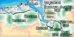
Location
- map: |
Marsh areas on the
western edge of the East Frisian peninsula, administrative district
Aurich, Lower Saxony, Germany |
|
Origin of name: |
The name Krummhörn,
colloquially also called the Krummhörn, appeared in the 16th century
for the first time, after which the East Frisian peninsula had
developed into an enclosed landscape and can be roughly translated as
‘crooked corner’. |
|
Relationship/similarities with other cultural entities: |
Similar natural and cultural landscape to
the neighbouring cultural entities around the river Ems (Rheiderland). |
|
Characteristic elements and
ensembles: |
Agricultural use,
fishing, coastal protection, rural house-forms, settlement
mound-villages, detached farm-settlement mounds, churches, dykes and
polders. |

2. Geology and geography
2.1 General
The wide marsh landscape of the Krummhörn is located on the western edge of
the East Frisian peninsula. In the south and in the west it is bordered by
the River Ems or its estuary, in the north by the
Leybucht (Ley Bay) and in
the east by the cultural entity of Brookmerland.
Historically the whole geographical area between
Greetsiel and
Oldersum was called
Krummhörn, comprising the present area of the boroughs of Krummhörn, Hinte,
Emden and parts of Moormerland. Today the name of the former cultural entity
is reduced to the area of Krummhörn borough situated in Aurich County. The
area of the Krummhörn borders directly on the Wadden Sea National Park of
Lower Saxony.
The Krummhörn is entirely comprised of former sea-marsh. Its present
appearance is essentially the result of an increase in the sea level around
300 B.C., as a result of which the coast line shifted to the south and bays
developed near Campen and
Sielmönken. At the same
time, mud-flat sediments were extensively deposited.
2.2 Present landscape
The present Krummhörn landscape is dominated by waterlogged lowlands,
unfavourable for agriculture. These developed in areas where silt covered
peatland shrank and subsided gradually under the superimposed load and/or by
drainage. As a consequence today’s lowland surface, such as in the
Freepsumer Meer, is in part up to 2 m below sea level. The bays of
Campen and
Sielmönken divide the
Krummhörn into older marshland and newer marshland; the latter was only
reclaimed piecemeal during the Middle Ages by dykes. In contrast to the
former area it has chalky and fertile soil, which still offers favourable
preconditions for farming and settlement. Drained marshes surrounded by
dykes require an extensive system of ditches, whilst in the lower areas of
the marsh pumping stations have to be used.
3. Landscape and settlement history
The Krummhörn has a complex settlement history, and its marsh landscape
reflects man’s continual struggle to gain and preserve the marsh for human
habitation. Characteristic monuments of the process are the dykes and
settlement/ dwelling mounds. The large scale investigation of the North
German mud flats, as well as to a smaller degree the Krummhörn marsh, has
been carried out by the Archaeological Service of the East-Frisian
Association (Ostfriesische Landschaft) and the Institut für historische
Küstenforschung (Institute for Historic Coastal Research) among others.
3.1 Prehistoric and Medieval Times
The large scale investigation of the North German mud flats and the
Krummhörn marsh, by the Archaeological Service of the East-Frisian
Association (Ostfriesische Landschaft) and others, has added considerably to
our understanding of this area. As a geologically recent area it is marked
by Quaternary deposits. The tidal river marshes of the Krummhörn have
developed since the end of the Ice Age until today.
The exact date when the Krummhörn was settled can only be determined
indirectly, on the basis of comparison with the surrounding areas. At the
beginning of the post-Ice Age, today’s southern North Sea coast was firm
land and the North Sea coast of that time was in the area of the Dogger
Bank. It is possible that there are sites of this or later phases below the
marsh and its layers of sediment deposits.
However, little is known about the beginning of settlement in the Krummhörn.
From the 1st century AD and in the following centuries the presence of a
number of lowland settlements has been established (e.g. near
Emden-Nesserland, on the
drainage-canal close to
Wolthusen and on the Uttumer
Escher). These settlements were apparently not significantly elevated
above the marsh and were as a consequence abandoned when the sea level rose.
A large number of village- and farm-dwelling mounds dating from the Middle
Ages and modern times are known. These were densely strung out along the
embankments of the River Ems as well as along the former shores of the bays
of Campen and
Sielmönken. A dwelling
mound-row stretches from
Manslagt (size approx. 10 hectare), which was formerly sited offshore on
a Hallig-like island near the bay’s coastline, across the northern edge of
the former Sielmönken Bay up to
Loppersum. On the southern edge of the bay a dwelling mound-row
stretches from Groothusen as
far as Suurhusen. On the bay
of Campen there are the
settlements of Rysum,
Loquard and
Campen. On the northern bank
of the River Ems the dwelling mound-row of
Wybelsum runs upstream along
the stream course via Emden
and Borssum. It is possible
that there are remains of earlier settlement-phases under these medieval and
modern dwelling mound-settlements. The size of each dwelling mound varies
considerably, ranging from a small farm-dwelling mound with only one
detached farm to a large village-dwelling mound with more than a dozen farms.
A classic example of a village-dwelling mound is the round village of
Rysum, formerly situated on
the Bay of Campen. Even in
the 19th century 15 big farms were still grouped concentrically around the
church in the middle of the village, as well as the smaller houses of
craftsmen and workers and the site of the former castle.
Apart from the round dwelling mound with their distinct settlement pattern,
there were also linear dwelling mounds in the Krummhörn, which have a
completely different character. These two dwelling mounds of
Groothusen and
Grimersum, each about 500 m
long and 200 m wide, were trading-places, whose inhabitants mainly lived of
crafts and service activities. Archaeological excavations in
Groothusen have revealed
that it was constructed as early as the 8/9th century in this form.
A comparable long dwelling mound, running from east to west, has been
excavated in the centre of Emden.
Today’s Emden developed very early, out of a number of closely situated
settlements, as a trading-place with a grid road system. A number of finds
of Rhenish imported ceramics and coins are evidence of active trading.
During excavations in the Grosse
Kirche in Emden two oak-posts were uncovered and dated to 966 by means
of dendronochronology. This is evidence for the oldest church in East
Frisia. From the early Middle Ages new areas of the region were developed,
spreading out from the village-dwelling mound. Excavations on the dwelling
mound in Middelstewehr and
Alt-Damhusen revealed
ceramics of the 8/9th century.
In the 12/13th century the building of dykes increased in momentum. Silting
up and dyke building secured the bays of
Campen and
Sielmönken as
settlement-areas. Inland colonisation was carried out by single farms.
Inspite of the construction of dykes as protection against floods, these
were still placed on small dwelling mounds of 1-2 m in height and 30 to 50 m
in diameter. Finds from the 13th and 14th centuries have been found in these
dwelling mounds, which were subsequently abandoned. The construction of
dykes requires intensive draining of the land, which led to the
characteristic drainage-ditches.
In the 14th century Greetsiel
was founded. Here the Greetmer Sieltief drained the northern marshland. As a
harbour it attained trans-regional importance and became the first residence
of the East Frisian counts of the Cirksena family.
Hinte and
Pewsum were further economic
and administrative centres. Nowadays the 15th century
Manniga-Castle, which has
been completely restored, still stands in
Pewsum. Up to 1565 it was
the seat of the chieftain’s family, the Mannigas.
3.2 Early Modern Times
Towards the end of the Middle Ages settling of the Krummhörn was largely
complete. However its isolated geographic position and the lack of common-
or fallow land made an influx from other cultural landscapes difficult.
Before 1600 severe storm floods led to repeated changes to the coast line
and made the strengthening of the dykes necessary. The Christmas flood of
1717, which inundated the whole area of the Krummhörn, cost the lives of 215
inhabitants.
East Frisia had been elevated to the rank of an imperial county in 1464 and
before 1600 had expanded to cover today’s region. In 1744 East Frisia,
including the Krummhörn, was integrated into the Kingdom of Prussia. After
the Napoleonic period of occupation from 1806 to 1813 it fell to the Kingdom
of Hanover. With its end the Krummhörn was restored to Prussia.
Since the end of the Middles Ages the fertile marshy ground in the Krummhörn
has formed the basis for the great wealth of the farmers. It made productive
farming and dairy pasturage possible. The majority of farms in the Krummhörn
were large or middle sized, so that the wealthy farmers required a great
workforce.
3.3 Modern Times
The number of inhabitants in the marsh-villages remained relatively stable
until the mid 19th century. The social structure of the Krummhörn was almost
exclusively regulated by the size of land owned. The farmers thus were at
the top of the social hierarchy, regardless of whether the land was owned or
leased. Being able to vote also depended on the ownership of land, as did
access to political and ecclesiastical offices. Workers and day labourers,
who owned no property, were at the bottom of the social hierarchy. In many
marsh villages the middle class was completely absent, being located instead
in the coastal towns and in the administrative centres. It consisted mainly
of business people, craftsmen and administrative officials.
Since 1950 a renewed increase of storm flood activity has been registered,
thus the tide-levels of 1962, 1976 and 1994 are amongst the highest ever
measured on the coast of Lower Saxony. The storm floods of 1953 and 1962 in
particular led to extensive extension and reinforcement work on the coastal
protection systems. The plan to build a dyke-ring around the entire Leybucht
(Ley Bay) was not implemented in the 1980s on account of the changed social
attitude towards coastal protection which now prioritises ecology. However
the last extensive strengthening of the outer dykes occurred only a few
years ago in Lower Saxony, when a dyke was built in Leybucht (Ley Bay). The
severe incursions of storm floods from the North Sea up the river Ems made
raising the dykes along the river essential. The severe March storm of 1906
led to a heightening of the dykes on both sides of the Ems, built between
1906 and 1913.
Pewsum, the administrative
seat of today’s administrative unit of Krummhörn is about ten kilometres
northwest of the municipality of
Emden. The administrative unit of Krummhörn, which covers 159,2 km2 of
the historic cultural landscape, emerged from 19 once-independent
communities in the framework of Lower Saxony’s community reform in 1972.
Today it has roughly 13.560 inhabitants.
The churches in the centre of round dwelling mounds, are of impressive
dimensions, considering the size of their communities, and most have a
higher architectural standard than for example the churches in
Campen and
Eilsum. The majority are
originally late Romanesque or early Gothic buildings. In the church of Rysum
there is the oldest playable original organ in Northern Europe of 1457.
The only two lighthouses in mainland East Frisia, are from more recent times.
They were erected between 1889 and 1892 off
Campen and
Pilsum on the Ems-dyke.
 |
| Typical settlement of the historic
landscape Krummhörn |
Big farms are characteristic of the Krummhörn. Some date back to the 16th
century and still play their part in shaping today’s landscape. Just as
typical for the image of the Krummhörn landscape is the contrast between the
compact village-dwelling mounds and the open marsh-areas with a small number
of single farm-dwelling mounds scattered across the countryside. This
settlement-structure was established in the Middle Ages and has lasted to
present times. The village cores have kept the old settlement-character too.
Due to the expansion of development areas with one-family homes, especially
in the vicinity of Emden,
the landscape is being more and more built-up and its typical character is
being threatened.
 |
|
Typical settlement of the historic landscape
Krummhörn |
In the 1990s the Leyhörn on the southern side of
Leybucht (Ley Bay) was
completed. The construction stretches as a spit of land into the mud flats
and includes a reservoir as well as an approach road from the lake to the
Greetsiel harbour. The use of the approach road to the harbour in Greetsiel
is independent of the tides thanks to the integration of a sluice in its
construction.
4. Modern development and planning
4.1 Land use
The marsh areas are still used traditionally for agriculture. The historic
coast line in the Leybucht
(Ley Bay) area is retained in the shape of the farm land. However in the
Krummhörn, the structural changes in agriculture can be also seen in the
growing number of farm-closures and the increasing farm size (scale
enlargement). This also leads to a decrease in arable farmland-areas in the
marshes and therefore to an increase in long-term meadowland. Here regional
factors play a minor role; it is the influence of EU agricultural policy,
which will lead to a further intensification of production.
Economically the role played by fishing is slight (there are still 28
shrimping boats at Greetsiel) although it is part of the culture of the
Krummhörn and is of importance for the people of
Greetsiel and for tourism as
a constituent of their traditional environment. The long-term existence of
this economic sector is questionable because of the de-population of fish
stocks in the North Sea.
The role of tourism in the Krummhörn is important. Its quality is based
particularly on the area’s historic land use structures and on its maritime
characteristics. Here especially the fieldscape, the dwelling mound-villages,
agricultural buildings, dykes, lighthouses and drainage-ditches should be
mentioned. Every year there are about 400.000 overnight-stays and roughly 1
million day-visitors are registered, with the main emphasis on the
fishing-village of Greetsiel.
A characteristic of the mud flats area of the North Sea coast is its high
biological productivity, for instance as a spawning ground for many types of
fish. Off the coast of the Krummhörn there are vital breeding and resting
areas for many kinds of birds. Parts of the foreshore of the dykes of
Krummhörn as far as the Ems-estuary are a part of Protective Zone I of the
Wadden Sea National Park of Lower Saxony, which as rest areas may only be
entered on marked paths.
4.2 Settlement development
The population of the Krummhörn is increasing due to immigration, while the
city of Emden registers a drastic decline. This is reflected in an increase
in one-family homes being built. Housing estates are expanding into the
countryside along the edges of dwelling mound-villages, altering the
historic village plans. This development can be seen in
Upleward,
Hamswehrum,
Groothusen,
Visquard,
Eilsum and
Uttum.
The north-side of the former dwelling mound-village of
Manslagt is still clearly
typical of its type, as are settlement structures of the village-dwelling
mound of Rysum. To this day
the landscape of the Krummhörn offers many possibilities to observe the way
in which the development of the countryside was organised from the dwelling
mound-villages throughout time.
Tourism is an important component of the economy of the Krummhörn and is
characterised by the rising number of overnight stays. The number of
visitors depends strongly on the season. In addition a great number of
employed people only live partially off tourism. Part-time employment and
seasonal employment play a big role.
 |
| Typical farmhouse building of the
historic landscape Krummhörn. The building was used as a combined
storage and residential building. |
Apart from the harbour of
Greetsiel, the national park house is also a tourist attraction. In the
centre of Pewsum there is the
Pewsum Castle museum. In addition there is a mill museum located in a
three-storey gallery-windmill in
Pewsum. The East Frisian Agricultural Museum is situated in
Campen. The Krummhörn can
offer a number of buildings worth visiting, such as the
lighthouse of Pilsum (13
meters high, it is the smallest lighthouse on the German North Sea coast),
the lighthouse of Campen (65
meters high – the highest lighthouse on the German North Sea coast), the
Church of the Holy Cross
from the 12th century in Pilsum, the
church in Eilsum from the
13th century, as well as the
church in Manslagt from the 14th century. The East Frisian Regional
Museum is located in Emden.
 |
| Typical farmhouse building of the
historic landscape Krummhörn |
4.3 Industry and energy
Industrial installations and the processing industries are mainly sited in
the city of Emden with its
VW-works, shipyards and seaport. There is a large trading estate in
Pewsum on the L 3, which
attracts consumers from the Krummhörn, Hinte and Emden. In
Greetsiel a new commercial
estate in being built on the L 25.
The gas and crude oil pipelines are significant trans-regional structures.
In addition gas is extracted at several places in the Krummhörn. There are
two natural gas wells to the west of Greetsiel and gas wells in the regions
of Uplewart and
Campen. Close to the
settlement of Rysum another natural gas power station exists.
Wind farms have been set up extensively in the Krummhörn to the west of
Pilsum south of
Visquard and southwest of
Manslagt, as well in the
Larrelter Polder. A number
of single wind turbines are scattered across the entire cultural entity.
4.4 Infrastructure
From the point-of-view of traffic the Krummhörn is marked by its distinctly
peripheral position. For a long time the ring roads around the
village-dwelling mounds and the smaller roads branching off them, shaped the
traffic-network which served the marshy areas. By 1863 a fully-developed
road connection developed between Emden, Aurich and Norden (today’s B 210
and 72). Up to 1893 the Krummhörn was only linked to the trans-national road
system by a number of country roads. Still today the Land roads follow the
old course of these roads.
A highly branched road system is necessary to connect all the rural
settlements and farms. The Krummhörn is linked via Emden by a number of Land
roads (L 2, L 3, L 4, L 25, L 27) and by local roads. The nearest points of
access to the motorway are near Emden, onto the A 31 (via the “Pewsum”
interchange amongst others).
On the 27th July 1899 passenger- and freight transport on a narrow-gauge
local railway, which was popularly called “Jan Klein”, opened on the line
between Emden and Pewsum. From the 27th September 1906 the extension of the
line reached as far as Greetsiel. All traffic however completely stopped on
the 25th May 1963. The railway was dismantled and public transport
transferred to buses. Today, the Krummhörn has no linkage to the national
railway network. The nearest railway stations are in Emden and Marienhafe.
Public transport is by bus.
The Krummhörn has access to shipping on the Federal waterways River Ems and
the North Sea via the harbours in Emden and Greetsiel. The harbour of
Greetsiel can be accessed from Emden by small boats. The
Alte Greetsieler Sieltief
and the Neue Greetsieler Sieltief connect the place with the East Frisian
inland waterway network.
5. Legal and spatial planning aspects
In matters of regional planning the Krummhörn region is subject to
the Land Planning Programme of Lower Saxony of 1994 with its supplements of
1998 and 2002, as well as Regional Planning Programme set up by the
administrative district of Aurich. In the Land’s regional planning programme
the city of Emden is categorised as the centre for this region. Apart from
the shipping waterways of the River Ems, the entire area of the coastal
waters has been declared as a priority-area for nature and landscape and
belongs to the Wadden Sea National Park of Lower Saxony. In the regional
planning programme of the administrative district of Aurich, Greetsiel is
named as a recreation/ tourist area and therefore the community was assigned
the special task of developing “recreation”.
The community of Krummhörn belongs to the administrative district of Aurich
and thus to the Ostfriesische Landschaft (East Frisian landscape). This is
the only upper communal association (Höhere Kommunalverband) in Lower Saxony.
As an institution it is responsible essentially for tasks such as the areas
of culture, science, preservation of historical monuments and education.
6. Vulnerabilities
6.1 Settlement
The continuously increasing population in the rural areas of the Krummhörn,
as a result from the movement of people from Emden, will lead to the
formation of further settlement areas, or expansion of existing settlements
and thus changes in the historic settlement pattern. Careful planning will
be required to protect and manage the surviving historic settlements.
6.2 Agriculture
In the Krummhörn, the structural changes in agriculture can be seen in the
growing number of farm closures and the increasing farm size (scale
enlargement). This leads to a decrease in farmland areas in the marshes and
therefore to an increase in long-term meadowland. Here regional factors play
a minor role; it is rather the influence of EU agricultural policy, which
will lead to a further intensification of production. This will mean that
both the present dispersed settlement pattern and the existing land use will
be vulnerable to change.
6.3 Industry and economy
The building of larger wind farms with higher wind turbines lead to changes
in landscape perception and thus in the character of the historically
evolved landscape. Investigations will be needed into the extent natural gas
extraction leads to a subsidence of the area of the Krummhörn, which is
increasing the threat of inundation.
6.4 Infrastructure
The rise in population figures in the Krummhörn will lead to an increase in
traffic on the Land- and Federal roads, as will the flow of commuters to
Emden. Increased local public transport can only be road transport because
of the lack of rail linkage in this area which will create pressure on the
historic structure of the road system.
6.5 Natural processes
A main problem of the future, which is difficult to predict, is climate
change which is progressing faster than expected. Since 1950 increasing
storm flood activity has been observed. Reinforced coastal
protection-measures with dyke heightening and dyke widening will be
necessary, requiring the quarrying of clay and sand needed for construction
purposes. The flooding danger is increased by the subsidence of land in the
Krummhörn, possibly triggered by drilling for natural gas. The Ems-estuary
is a specifically endangered area. It has become a “gateway” for storm
floods due to the constant changes, straightening and deepening, as well as
the building of dykes. Evidence for this is the drastically increased range
of tides and the clear increase in extreme water levels. Any plans to
protect the area will need to have the cultural heritage interests as an
integrated part of the proposals.
7. Potentials
7.1 Strategic Planning
To both protect and promote Krummhörn overall planning beyond the boundaries
of the single cultural landscapes has become increasingly necessary. The
crucial basis for the East Frisian area has been set up with the
establishment of the Regional Structure Conference East Frisia, which
amongst other things led to the founding of the Integrated Traffic System
Ems-Jade (EVS), and the Regional Innovation Strategy for Tourism. The
advantages of Krummhörn and its neighbouring region, can be increased and
its disadvantages decreased by the interlinking of the cycle tracks and
footpaths, as well as a programme range covering the single cultural
landscapes.
7.2 Settlements
In Krummhörn most forms of settlement and land use, adjusted to the lives of
the people in the marshes of the North Sea coast, are preserved to a large
degree. The relationship of the settlements with the natural landscape can
be seen as the cultural and historic heritage in the landscape:
farm-dwelling mounds, village-dwelling mounds, old and new dyke-lines (e.g.
in the former Leybucht/ Ley Bay), areas of brackish water, colcs, clay pits,
and drainage ditches reflect the interactions in the past and the present
with the sea. This pattern provides great potential for the promotion of the
area both in the production of traditional produce and for the tourist
industry.
7.3 Agriculture
An important pre-condition for maintaining the traditional structure of the
landscape and the buildings within it is the use of the land by private
individuals, tourism and agriculture. A chance of linking the two economic
branches, tourism and agriculture, could be the expansion of ecological
agriculture, as well as the inclusion and encouragement of farmers in
processes aimed at preserving the countryside.
7.4 Tourism
The great attractions of the landscape of the Krummhörn for tourism are a
potential source of economic development. The preservation of the
attractiveness of the landscape and the improvement of the tourist
infrastructure (hotels, restaurants, footpaths, etc.) is vital for this. In
view of the peripheral location of the Krummhörn on the mainland the
possibility of intensifying co-operation with neighbouring cultural
landscapes should be examined. At the same time care must be taken that the
original character of the cultural landscape is not completely lost but is
integrated in the development of the Krummhörn in accordance with future
requirements. A decision to classify the whole Dutch-German Wadden Seas area
as a “Place of World Natural Heritage” could open opportunities. This would
protect this region of the North Sea better – up to now it has been only
classified as World Culture Heritage with emphasise on “shipwrecks” – and
prevent negative developments. Encouraging and promoting the historic
settlements, landscape and museums of the area will increase the tourist
industry and help in the protection and management of the cultural heritage
assets.
8. Sources
Author: Wolfgang Scherf (Translation: Mai-Catherine
Botheroyd)
Behre, K.-E. (1999): Die Veränderungen der niedersächsischen Küstenlinien in
den letzten 3000 Jahren und ihre Ursachen. Probleme der Küstenforschung 26,
9–33.
Behre, K.-E. (1999): Naturraum und Kulturlandschaftsentwicklung
Ostfrieslands. Führer zu archäologischen Denkmälern in Deutschland 35.
Ostfriesland. Stuttgart, 10–27.
Beise, J. (2001): Verhaltensökologie menschlichen Abwanderungsverhaltens –
am Beispiel der Krummhörn (Ostfriesland, 18. und 19. Jahrhundert).
Dissertation; Gießen.
Brandt, K. (1992): Besiedlungsgeschichte der Nord- und Ostseeküste bis zum
Beginn des Deichbaus. In: J. Kramer & H. Rohde, Historischer Küstenschutz,
Deichbau, Inselschutz und Binnenentwässerung an Nord- und Ostsee. Stuttgart,
207–240.
Bundesamt für Bauwesen und Raumordnung (BBR; 2005): Raumordnungsbericht
2005. Berichte 21, Bonn 2005.
Jeschke, A. (2004): Raumplanung als vorsorgendes Instrument im
Küstenmanagement. Oldenburg.
Kramer, J. (1992): Küstenschutz und Binnenentwässerung zwischen Ems und
Weser. In: J. Kramer & H. Rohde, Historischer Küstenschutz, Deichbau,
Inselschutz und Binnenentwässerung an Nord- und Ostsee. Stuttgart, 207–240.
LANCEWAD (2001): Landscape and Cultural Heritage in the Wadden Sea Region –
Project Report. In: Common Wadden Sea Secretariat (Hrsg.), Wadden Sea
Ecosystem. Wilhelmshaven.
Landkreis Aurich (1992): Regionales Raumordnungsprogramm des Landkreises
Aurich. Aurich.
Lengen, H. van (1999): Burgenbau und Stadtentwicklung. Führer zu
archäologischen Denkmälern in Deutschland 35. Ostfriesland. Stuttgart 1999,
128-140.
Niederhöfer, K. (2004): Archäologie im Wattenmeer. In:
Archäologie?Land?Niedersachsen. 25 Jahre Denkmalschutzgesetz – 400 000 Jahre
Geschichte. Archäologische Mitteilungen aus Nordwestdeutschland, Beiheft 42.
Stuttgart, 511–513.
Niedersächsisches Institut für Wirtschaftsforschung (NIW; 2005):
Regionalbericht Norddeutschland 2005. Hannover.
Raumordungskonzept für das niedersächsische Küstenmeer. Herausgegeben vom
Niedersächsisches Ministerium für den ländlichen Raum, Ernährung,
Landwirtschaft und Verbraucherschutz - Regierungsvertretung Oldenburg -
Landesentwicklung, Raumordnung. Stand 2005.
Reinhardt, W. (1999): Die Wurtenlandschaft der Krummhörn. Führer zu
archäologischen Denkmälern in Deutschland 35. Ostfriesland. Stuttgart,
245–247.
Reinhardt, W. (2000): Die Krummhörn. Archäologische Denkmäler zwischen Weser
und Ems. Archäologische Mitteilungen aus Nordwestdeutschland, Beiheft 34.
Oldenburg, 206–211.
Rödiger, H.-B. & Ramm, H. (1979): Friesische Kirchen im Auricherland,
Norderland, Brokmerland und im Krummhörn. Jever.
Seedorf, H. & Meyer, H.-H. (1996): Landeskunde Niedersachsen 2. Natur- und
Kulturgeschichte eines Landes. Niedersachsen als Wirtschafts- und
Kulturraum. Neumünster.
Strahl, E. (2004): Archäologie der Küste: Marsch, Watt, Ostfriesische
Inseln. In: Archäologie?Land?Niedersachsen. 25 Jahre Denkmalschutzgesetz –
400 000 Jahre Geschichte. Archäologische Mitteilungen aus
Nordwestdeutschland, Beiheft 42. Stuttgart, 495–510.
Thieme, H. (1997): Älteres Paläolithikum aus dem Gebiet zwischen Weser und
Elbe. In: L. Fiedler (Hrsg.), Archäologie der ältesten Kultur in
Deutschland. Materialien zur Vor- und Frühgeschichte von Hessen 18, 328–356.
Full catalogue of historic maps used, survey evidence etc.
Karte des Nordwestlichen Teils von Ostfriesland. Herausgegeben vom
Generalmajor Le Coq 1805, Sect. III. Nachdruck 1984.
|