|
1. Overview
|
Name: |
Land Hadeln |
|
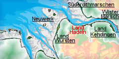
Delimitation: |
River Elbe, Geest ridges
Hohe Lieth, Wingst, Westerberg, Geest border Bederkesa, neighbouring
entities Land Wursten, Land Kehdingen |
|
Size: |
Approx. 725
km² |
|
Location
- map: |
Tidal river marsh south
of the Elbe estuary in Cuxhaven district, in Lower Saxony, Germany |
|
Origin of name: |
The name Hadeln is
derived from the early Saxon “Gau” (province) Haduloha, which at that
time referred to the entire territory between the Elbe and Weser
estuaries. In this context, Land Hadeln is known as the elder brother
of Land Wursten. The oldest documentary record of Haduloha goes back
to Widukind von Corvey, who was an enemy of Charles the Great. |
|
Relationship/similarities with other cultural entities: |
Moor colonies Teufelsmoor
(Devil’s Moor) near Bremen, marsh farmland on the Dollart,
terp-villages, Krummhörn, linear settlements near Aurich |
|
Characteristic elements and
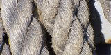
ensembles: |
Typical maritime
character reflected by dykes and associated drainage-systems (ditches
or canals) as well as strip fields, dwelling mounds, churches,
farmsteads, pumping stations |

2. Geology and geography
2.1 General
The Land Hadeln is a 22 km to 25 km broad marsh-area close to the estuary of
the River Elbe near Cuxhaven on the North Sea. Embedded between the Hohe
Lieth in the west, the Wingst and the Westerberg in the east, the Handeln
Marsh stretches about 25 km in a southerly direction as far as the Bederkesa
Moor Geest. Hadeln Bay belongs to the sea-marsh area of the Elbe-Weser
region, which formed due to marine conditions.
A distinction is made between the landscapes derived from the different
sedimentation levels before the establishment of the dykes; that is between
the highland with its sandy, chalky soil in a 5 km wide strip close to the
coast and the lower lying land with its clayey soil. The main focus of
settlement is on the highland which is on average about 15 m above sea
level. The Hadeln low lying land which roughly begins in Neuenkirchen, goes
down to less than 0.5 m under sea level and, due to the lack of drainage, is
very marshy, especially on the Geest edges. This area is surrounded by a
ring of lakes, such as the Flögeln- and Bederkesa Lakes as well as the Balk
Lake.
The geology of Hadeln includes areas of partial salt deposits dating from
the Zechstein period. The sedimentations of the Eemian era beneath the
Holocene deposits of the post-Ice Age are also geologically remarkable.
Peats near Osterwanna provide information on climate and vegetation
conditions during the Eemian interglacial era, and have become a European
standard due to their completeness.
2.2 Present landscape
Essentially the Land Hadeln is limited to the marsh surrounded by dykes,
south of the Elbe estuary. Here the prevailing agricultural land-use is
traditional. In the highland part of the fertile sea-marsh, tillage and
fruit growing are undertaken. On the low lying land located behind it,
predominantly dairy cattle are kept on extensive pasturage.
Only after extensive drainage-measures, could the low lying land be settled
continuously. Parallel, straight drainage-ditches running side by side,
divide the Land into strip-shaped fields. Nowadays the strip fields are an
essential characteristic of the Land Hadeln. With the aid of extensive
canal-systems and pumping stations it was possible, in the 19th and 20th
centuries, to conduct the water against the natural incline through the
highland of the Land Hadeln into the Medem (Hadeln Canal, Neuhaus-Bülkau
Canal), which flows into the Elbe close to Otterndorf. The problem of
draining the Hadeln low lying land, which is crossed by the Aue, Gösche,
Mühe and Emelke, can be traced back to the year 1219 in documents.
Today the mire and raised bog areas in front of the Geest-ridges are
designated as nature reserves. Amongst them is the roughly 40 km2 large
Ahlenmoor and smaller peatland-areas around Wanna, the only Geest-community
in Land Hadeln. Like islands, the small sandbanks, up to 20 m high project
from the low lying area of Ost- and Westerwanna. Comparable with the “Hohen
Lieth“, the Westerberg, the Wingst and the Bederkesa Geest, they have
developed in the course of the penultimate Ice Age. Some of these Geest
areas have extensive woodland.
3. Landscape and settlement history
The Land Hadeln has a complex settlement history, in the marsh landscape
man’s continual struggle to gain and preserve his habitat can still be
observed in the characteristic dykes and dwelling mounds.
3.1 Prehistoric and Medieval Times
The coast line of the North Sea has changed frequently in the course of the
Earth’s history. Towards the end of the Ice Age, roughly 10.000 years ago,
another low-land bay existed on the southern Elbe estuary. Due to the rising
sea level, tidal change led to the flooding of Hadeln Bay at high tide. At
low tides the materials transported by the water were deposited, so that the
marsh grew slowly higher over the course of millennia.
The first settlement traces go back to the Palaeolithic Age and are
restricted to single finds of flint artefacts, like the flint found in Wanna
and from the Wingst. They are assigned to the Upper Acheuléan period,
chronologically to the end of the penultimate Ice Age, and are found in
connection with Neanderthal man.
Unlike the Palaeolithic, a number of Mesolithic finds are known in the
Elbe-Weser area. They are partially from the neighbouring regions of the
Land Hadeln, for instance from Neuenwalde and Hemmoor-Westersode close to
the Wingst.
With the beginning of the Neolithic period (roughly 3000 BC) the human
impact on landscape in the Elbe-Weser area increases. One of the discernible
changes in the natural landscape is the introduction by the humans of
farming and livestock breeding. This phase of land settlement in North
Germany is most obvious in the Elbe-Weser area of Flögeln, north-west of
Bederkesa on the Geest. Pollen diagrams from kettle-hole bogs indicate the
existence of grasses and heather in a clearing in the forest suggesting that
grazing went on. Spelt and hull-less barley as well as some emmer were grown
as cultivated plants. At the site of Flögeln there are the outlines of
houses from the Neolithic Funnel Beaker culture (Trichterbecher Kultur;
TRB), which provide information about the settlements of that time. Today
the Neolithic burial places stand out in the landscape, and numerous
examples were erected in the Land Hadeln. including those of Wanna and the
Ahlenmoor. The burial places there were partially covered by the moor and
are therefore well preserved. The cause of the growth of peatland at this
time was the rise of the ground water level, which made the formation of the
raised bogs possible.
For the Bronze Age there are many archaeological sites in the Elbe-Weser
region. In particular tumuli and urn cemeteries, as well as some settlement
traces, are worthy of mention. Nevertheless, there has been a lack of major
settlement excavations. The man-made landscape hardly changed in the
pre-Roman Iron Age either. However, there is a considerable increase of
settlement activity, which intensifies in the northern Elbe-Weser area in
the following Roman Imperial/Migration Period. This is also apparent in the
beginning of the terp (settlement mounds)-building in the marsh around
Christ's Birth, as well as in the continued settlement in the Geest-areas,
for instance, in Flögeln-Eekhöltjen. Up to that time the settlement of the
marsh was subject to variations in the sea level. This also holds true for
the first small Iron Age settlements on the sandy ridges, but only with the
beginning of terp-building was permanent settlement possible in the
flood-endangered areas.
There are large old village-terpen in the west of the highland of Hadeln
between Lüdingworth and Dörringworth, as well as on the Medem between
Neuenkirchen and Otterndorf, and to the east of Otterndorf in Westerwörden.
The terpen were settled until the 5th century and today they still rise
above the surrounding areas by a few metres. They reflect the coastline of
the North Sea or the shoreline in the tidal-area of the particular
river-system during its settlement-phase.
An early medieval re-settlement, like the one which is documented for the
neighbouring coastal land of Wursten, by a new terp-building phase in the
7th/8th century, can probably also be assumed for the Land Hadeln.
Similarly, the question is still open, as to when the low lying land was
cultivated for the first time. An indication of this is in the setting up of
linear settlements, starting in the 12th/13th century on the north and east
edge of the Ahlenmoor, from which the moor was cultivated bit by bit by
peat-cutting.
With the medieval dyke-building the terpen lost their function as a
protection from storm floods. It is assumed that the first medieval
winter-dyke in Hadeln was set up parallel to the coast in the 12th century
(“Hadler Seebanddeich”). It was presumably planned by Dutch colonists. A
comparable development has been passed down to us for the Hamme-Wümme
depression near Bremen in a document from 1113. Today there are still
sections of old dykes, in separated sections,preserved near Otterndorf.
However, they did not belong to the continuous winter-dyke, but where water
divides between areas of different drainage direction.
It was only after 1469 that dykes were built at the mouth of the Medem. The
church of Otterndorf, founded in the 12th century, was up to the middle of
the 15th century in the area beyond the outer dyke. All in all there were 12
parishes in the Land Hadeln. The town of Otterndorf had a prominent position
in the Elbe-Weser area for several centuries. In the core of the old town
the original arrangement of the terp of Otterndorf is still recognizable.
3.2 Early Modern Times
The Reformation asserted itself in the Elbe-Weser area in the middle of the
16th century and found quicker acceptance in the Land Hadeln, which was
under the supremacy of the Dukedom of Saxony-Lauenburg, than in the lands
under archiepiscopal rule. After the losses of the Thirty Years' War the
need rose for ecclesiastical furnishings, which in the 17th and 18th century
often came from farmers’ donations. The churches in Hadeln in particular
reflect the economic prosperity of the large farmers, and this is also
evident in the development of splendid buildings combining living and
working quarters in the Hadeln highland. The churches of the Land are also
called "farmers’ domes" (Bauerndome).
In the second half of the 17th century, further settlements were built on
the peatland edges, and the intensified deforestation of the Geest led to an
increase in peat-cutting so that heating-fuel could be obtained. In this
cultivation-phase Westerende, Mittelteil, Steinau-Westerseite and Medemstade
came into being. The development of new land improvement techniques also
ameliorated the conditions for agriculture in the low lying land. Suitable
meadowland could now be transformed into farmland. While the settlements in
the low lying land, such as Bülkau, Oppeln and Steinau, mainly represented
the type of closed marshland village with relatively closely positioned
houses, the linear settlements of the northern highland, such as Altenbruch
and Lüdingworth, take the form of a loose structure of detached farms.
From the early Modern Times the Land Hadeln was regarded as a granary, which
supplied grain to Hamburg in particular. An important upswing in agriculture
was closely connected with cultivation of rape-seed from the middle of the
18th century. Today there are remnants of the former field-use left in the
low lying land.
3.3 Modern Times
In the mid 19th century the Hadeln Canal and the Neuhaus-Bülkau Canal were
extended, which not only made for better drainage of the low lying land, but
also ensured transport inland via the waterways. The marsh-clay, which was
obtained by digging and canal construction, was turned into bricks and
shipped to many flourishing industrial towns.
A crisis in the in marshland economy, caused by the fall in grain and oil
prices, occurred in the second half of the 19th century. Despite a change in
production to meadowland farming with livestock fattening, people emigrated
from the region. Another possible reason for this was malaria, which was
raging in the region. Between 1873 and 1892 roughly 10% of the population of
Hadeln emigrated to America.
In 1881 the railway-line Cuxhaven-Hamburg was built and the extension of the
Cuxhaven-Stade line via Otterndorf was progressing. Ottendorf, for centuries
the economic, political and cultural centre of a farmers’ republic in the
Land Hadeln, was thus relegated to the level of a small country-town within
a very few centuries due to the up-and-coming developments in neighbouring
Cuxhaven.
From 1824 onwards horse-breeding played a role in the Land Hadeln, and it is
still carried on today, for example in the traditional competitions in Am
Dobrock in the Wingst show.
With the appearance of machine-driven pumping works it was finally possible
to protect the low lying land against the permanent threat of flooding.
Since the 20th century numerous pumping works are responsible for the
artificial drainage of the Handeln low lying land. In the 1960s the Oste dam
was built. Here the course of the Oste had to be changed in this area. The
old stream bed below the dam was filled in. Today the remaining old arm of
the river has become a tourist facility for water-skiing.
4. Modern development and planning
4.1 Land use
The Hadeln highland is one of the few marshland arable farming areas in
Germany. Due to the fertile ground, the annual harvests are rich in yield.
In the low lying land with its marsh meadowland areas, dairy farming is
undertaken. The region has remained an area of traditional farming land.
In the whole regional administrative area of Cuxhaven (the former areas of
the Land Hadeln and Wesermünde; complete size: 201.000 inhabitants on 2072
km2) the number of workplaces in industry, including the processing
industry, are below average. In agriculture the number of employees subject
to compulsory social-insurance is twice as high as the average. In
comparison to 1990 the numbers here decreased by 43%, whilst increasing by
38% in the service sector. Thanks to the fish processing industry in the
city of Cuxhaven, the administrative district is one of the leading regions
in German food production.
4.2 Settlement development
Over the last few decades the number of inhabitants in the region of
Cuxhaven has been in decline. In general the Land Hadeln is thinly
populated; the main settlement-areas are located on the highland. Today the
town of Otterdorf, which is known for its 17.5 kilometre long beach, is a
North Sea seaside resort and the seat of the administrative district of
Hadeln. The approximately 10,000 inhabitants of the district live in a
community with historically evolved central functions. Due to the variety of
existing public institutions, the North Sea resort is a desirable place to
live. Traditionally a great emphasis is put on culture. The
communications-centre “Stadtscheune” with its museum of modern art, offers
space for many events. Besides trade, business and agriculture, tourism has
strongly developed during the last few years. Holiday home estates with more
than 150 living units, two camp-sites, sports and play grounds on a bathing
lake, the “lawn-beach” and a salt water indoor swimming pool are at the
visitors’ disposal.
Fishermen can use the coast, rivers and lakes for their sport. The Hemmoor
Kreidesee is a good example; it has also become important over the last
decades for international scuba-diving. For recreational sailors too, the
area on the Oste and the Elbe with its connection to the North Sea and many
small and big harbours and ports (Cuxhaven) is interesting and much used.
Altogether, the administrative district of Cuxhaven has registered an
exemplary upswing in tourism: the number of overnight stays rose in 1987
from 4.88 million to 5.87 million in 1998. 3 million overnight stays were in
the town of Cuxhaven. Otterdorf and the medicinal bog spa Bad Bederkesa are
among the successful North Sea bathing resorts. According to the information
of the Integrated Rural Development Concept ILEK, the number of overnight
stays in the Land Hadeln has stagnated recently.
It is not only in the administrative area of Hadeln that the
cultural-managers are investing in cultural identity. Burg Bederkesa is a
museum and the seat of the office for the archaeological preservation of
historical monuments, Studio A - a museum known nationally for abstract art
- and for the archives of the district Otterndorf are managed by
specialists.
4.3 Industry and energy
The Land Hadeln is an area still largely untouched by industry; it has,
however, got numerous wind turbines. Numerous industrial enterprises have
located in neighbouring Cuxhaven. The fish-processing industry, the
manufacturing of metal packaging, technical apparatus construction and
machine factories for the pharmaceutical, cosmetics and food industries are
of great importance for economic growth.
There are big deep freeze-depots for fish, meat and fruit in Cuxhaven/
Otterndorf. The production of mineral building materials and the concrete
works are of national significance for the building industry. Poultry
production and breeding are another main focus. In Cuxhaven, market-leading
enterprises are represented in the areas of pharmacy and dental medicine, as
well as in the environmental sector, such as in the area of wind-energy and
ground rehabilitation, which are active nationally.
The net-company Ems-Elbe (Stade) is responsible for the electricity supply
in the Elbe-Weser triangle. It provides the highest- and high-voltage
overhead transmission-system with the levels of 380, 220 and 110 kV. A
group-switch line, from which all means of production can be
remote-controlled, belongs to the net-company.
4.4 Infrastructure
The motorway A 27 follows the north-south course of the westerly Geest ridge
“Hohe Lieth“, and separates the Land Hadeln from the Land Wursten on the
North Sea coast. Via the A 27 the region is connected to Bremen, Hanover and
the Ruhr Area and via the B 73 to Hamburg and the former East German Länder
(federal states). The port of Cuxhaven only few kilometres away – nerve
centre between the North Sea and the Baltic - has gained importance since
the opening of the Amerikahafen in 1997. Since 1999 there has been a
car-ferry connection on the Elbe to Brunsbüttel in Schleswig-Holstein.
Furthermore Cuxhaven is also connected to Hamburg and the European inland
waterways network via the river Elbe.
Otterndorf is linked to the railway-line from Cuxhaven to Hamburg. From
Cuxhaven a railway line runs to Bremerhaven. From there a link exists to the
ICE high speed train network of the Deutsche Bahn AG. The rail
passenger-traffic from Cuxhaven to Hamburg is heavier than on the stretch
from Cuxhaven to Bremerhaven. The nearest large airports are in Bremen and
Hamburg. The airport Cuxhaven/Nordholz was originally a military
installation and was only very recently opened to civilian freight traffic.
The administrative district of Cuxhaven has numerous developed
industrial-zones and estates, some of which are sited close to the motorway
and to the Nordholz Airport. The prices for trade- and residential
properties in the administrative district of Cuxhaven are amongst the lowest
in the Federal Republic.
5. Legal and spatial planning aspects
In historic times the boundaries of the Land Hadeln changed several
times, and a county of Hadeln continued to exist into modern times. In 1972
the administrative district of Hadeln came out of the merger of five
administrative areas: Hadeln with its seat in Otterndorf, Sietland with its
seat in Ihlienworth, Am Dobrock with its seat in Cadenberge, Hemmor and
Börde Lamstedt. In 1977 the administrative districts of Land Hadeln and
Wesermünde were merged with the independent city of Cuxhaven into one
administrative district with its seat in Cuxhaven.
Regional planning is subject to Lower Saxony’s land planning programme as
well as the regional area and land use planning programme put forward by the
communities. The Regional Development-Concept for Hamburg as well as the
regional structure concept for the coastal waters of Lower Saxony are
integrated into this. Since 2006 an Integrated Rural Development-Concept
ILEK task force is working in the Land Hadeln to develop systems to
safeguard the future of the region. If suitable the implementation of the
ideas can be supported by funding from the EC, the Federal Government and
the Land (federal state).
6. Vulnerabilities
6.1 Settlement
There is a danger of the development of so-called dormitory villages
which runs contrary to the intended stimulation of the town and village
centres and the expansion of public services. Such dormitory villages will
affect the historic settlement pattern of the area.
6.2 Agrciulture
Pressure from international competition, resulting from globalisation,
to optimise agricultural land use will result in the intensification of
agricultural production and stuctural changes. In order to remain
competitive, farm sizes will inevitably have to be increased. The historic
fieldscape, including the long strips of land typical of the Elbe marshes,
and other landscape features, would be threatened due to increases in the
size of farm machinery. The expansion of production areas could lead to
monocultures and could destroy the historically grown settlement pattern
with redundancy of some farms.
6.3 Tourism
Due to the steady increase in population in the conurbations, there will
be a danger of mass-tourism affecting the recreational areas of the rural
greenbelt bringing pressure on the cultural heritage.
6.4 Energy and industry
The lack of big companies and industrial estates in the area could lead
to a further population drain and, through commuter movements, daytime
de-population which could result in negative consequences for the
maintenance of the historic landscape.
6.5 Infrastructure
The German seaports such as Cuxhaven are demanding a significant
improvement to their hinterland connections for the future. This demand
would signify a further extension to the infrastructure of the area causing
interference with the cultural landscape of Hadeln, with a negative
‘knock-on’ effect on tourism.
6.6 Natural Processes
There is an ongoing danger of flooding in the coastal areas as a result
of continuing global warming.
7. Potentials
7.1 Settlement
There are ongoing efforts to revitalise village centres in the area to
improve future quality of life for the residents. In the meantime Hemmoor
has become one of the central focal points in the region, on which the
town-rights were conferred in 1982. The Land Hadeln offers favourable real
estate and has comparatively inexpensive building land and stable rents.
7.2 Agriculture
In the agricultural sector the identity of “Milkland” Hadeln could be
marketed even further as a means of branding the area and its produce. A
possible alternative for farm incomes would be the strengthening of the
traditional local horse breeding and ownership.
7.3 Tourism
The Land Hadeln has retained its rural character to a great extent. The
scenery and settlement forms still clearly reveal the old structures in many
areas, including: old dyke structures, marshes, marshland villages, drainage
channels, peatland colonies and many raised terpen and banks. The regional
administration is aware that the potential of the areas natural and man-made
resources such as dykes, drainage-channels, peatlands, lakes, Geest ridges,
agricultural working areas and technical monuments (e.g., pumping stations)
can be used increasingly for tourism and thus create workplaces in the
service sector. Numerous church buildings and other cultural monuments,
often with maritime character e.g. lighthouses are equally tourist
attractions. The Natureum close to Neuhaus/ Balje with its didactically
presented exhibition concept is especially suitable for school classes. Here
the meaning of the natural landscape with its local animal and plant world
is clearly conveyed to the visitor. The museums and other cultural
institutions of the area are headed by experts and mediate up-to-date
research-results with their exhibition concepts and/ or emphasize cultural
and regional identity (e.g. local museum, farmhouse parlour). The situation
of the highland at the mouth of the Elbe and on the North Sea area, and the
historic watercourses in the low lying land provide areas for soft tourism.
Overall tourism concepts and a sharper focus of the profile of the region
could stimulate the development of tourism in future. The campaign “German
Ferry Routes“, which successfully demonstrates and markets the potentials of
the maritime scenery of the Lower Elbe, is a positive start in this respect.
7.4 Industry and energy
The immediate proximity to the port of Cuxhaven is useful for trade and
industrial estates. The varieties of trade and craft industries demonstrate
strong medium-sized industrial activity. The strengths of the region in
future will most certainly show in the quality of the location for the
settlement of companies. The Land Hadeln has extremely low property-prices,
has got sufficient land for industry and a favourable cost level for
producing industry. There are attractive locations for the further expansion
of wind energy and bio-energy.
7.5 Economy
With its expansion into a modern seaport, the harbour of Cuxhaven has
triggered off a growth impulse which could affect the economic well being of
its periphery in the future just as positively.
8. Sources
Author: Andrea Finck (Übers. Mai-Catherine Botheroyd)
Behne, A. (Hrsg.; 2000): Otterndorf, 600 Jahre Stadtgeschichte an der
Nordsee. Otterndorf.
Behre, K.-E. (1995): Kleine historische Landeskunde des Elbe-Weser-Raums.
In: Geschichte des Landes zwischen Elbe und Weser I. Vor- und
Frühgeschichte. Stade
Bundesamt für Bauwesen und Raumordnung (BBR; 2005): Raumordnungsbericht
2005. Berichte 21, Bonn.
Böker, D. (1997): Denkmaltopographie Bundesrepublik Deutschland. Baudenkmale
in Niedersachsen Landkreis Cuxhaven 19. Hameln.
Dannenberg, H.-E. & Schulze, H.-J. (1995): Geschichte des Landes zwischen
Elbe und Weser I. Vor- und Frühgeschichte. Schriftenreihe des
Landschaftsverbandes der ehemaligen Herzogtümer Bremen und Veren 7. Stade.
Elbe-Weser-Raum (1999): Auf den Weg ins 21. Jahrhundert. München.
Ergebnisillustration der „Zukunftswerkstatt“ ILEK Hadeler Region, erstellt:
Dr. Greiser und Partner
LANCEWAD (2001): Landscape and Cultural Heritage in the Wadden Sea Region –
Project Report. In: Common
Wadden Sea Secretariat (Hrsg.), Wadden Sea Ecosystem. Wilhelmshaven.
Lembcke, R. (Hrsg.; 1976): Kreis Land Hadeln. Geschichte und Gegenwart.
Otterndorf.
Niedersächsisches Institut für Wirtschaftsforschung (NIW; 2005):
Regionalbericht Norddeutschland 2005. Hannover.
Raumordungskonzept für das niedersächsische Küstenmeer. Herausgegeben vom
Niedersächsisches Ministerium für den ländlichen Raum, Ernährung,
Landwirtschaft und Verbraucherschutz - Regierungsvertretung Oldenburg -
Landesentwicklung, Raumordnung. Stand 2005.
Schumann, N. (Hrsg.; 1978): Hadeln und Wursten. Land hinterm Deich. Hamburg.
Seedorf, H. & Meyer, H.-H. (1996): Landeskunde Niedersachsen 2. Natur- und
Kulturgeschichte eines Landes. Niedersachsen als Wirtschafts- und
Kulturraum. Neumünster.
Thieme, H. (1997): Älteres Paläolithikum aus dem Gebiet zwischen Weser und
Elbe. In: L. Fiedler (Hrsg.), Archäologie der ältesten Kultur in
Deutschland. Materialien zur Vor- und Frühgeschichte von Hessen 18, 328–356.
|