|
1. Overview
|
Name: |
Land Kehdingen |
|
Delimitation: |
River Elbe, River Oste,
River Schwinge, neighbouring entities Altes Land, Land Hadeln and
Ahlenmoor |
|
Size: |
Approx. 441 km² |
|
Location
- map: |
Tidal river marsh of
Lower Saxony, Lower Saxony, Germany |
|
Origin of name: |
Not known |
|
Relationship/similarities with other cultural entities: |
Strip fields as in Land
Hadeln, Kremper-Marsch, and Altes land, brickworks in the Elbe-marshes. |
|
Characteristic elements and
ensembles: |
Plantation landscape,
rural house forms, linear settlements, brickworks in the Elbe-marshes,
dwelling mounds, dykes, drainage ditches, lighthouses, strip fields. |

2. Geology and geography
2.1 General
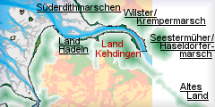
The cultural entity of Land Kehdingen originally stretched as far as the
mouth of the Oste in the north and in the south to the mouth of the
Schwinge, which flows into the Elbe close to the town of Stade. To the east
the River Elbe and to the west the River Oste form the natural boundaries.
Geologically this region can be subdivided into deposits derived from mud
flats, brackish water areas, fluvial tides, as well as peat marsh and raised
bog areas. The Kehdingen marsh areas developed after the end of the Ice Age
due to silt gradually covering the gravels and sands deposited by the river
Elbe. The fact that Land Kehdingen is located between the two parallel
rivers, the Elbe and Oste, gives it its special character. Both rivers are
tidal, which has led to the formation of a highland along its banks. As a
consequence the drainage form the lower land in between the rivers is poor
and this has led to the formation of the nearly 25 km long Kehdingen Moor.
The land drops from about 2m above sea level in the area of the highland and
the foreshore of the dyke to 1m below sea level on the border to the fen.
2.2 Present landscape
The Land Kehdingen is located in the administrative district of Stade and
consists of the modern administrative areas North Kehdingen and the
community of Drochtersen.
The present image of the Land Kehdingen is marked by the historic dyke-lines
of the Elbe-dyke in the north and by the Oste-dyke, the so-called Süderdeich,
in the east. The landscape of the north-westerly area is shaped by strips of
land orientated according to the dyke, by scattered linear settlements on
the dykes and by single farms, some built on dwelling mounds (settlement
mounds).
Within the entire area, the appearance of the cultural landscape of the Land
Kehdingen is dominated by strips of land, which are still clearly visible
today, due to the unchanged settlement forms (here marshland settlements).
Other elements of the cultural landscape which have been preserved are the
dwelling mounds, the dykes along the rivers which separate the cultivated
land (polders) against the marsh by means of the inner-dyke, Wettern (drainage
ditches) and the “Doppelhallenhöfe”, which are typical of Kehdingen. In
comparison to the Altes Land, there is a greater variety of visible field-
and settlement forms in Kehdingen, due to the un-planned land development
here since medieval times. In spite of some degree of superimposition and
interference with the historic original, due to the modern settlement
expansion in the 20th century, the situation regarding preservation is very
good in comparison to other cultural landscapes of Lower Saxony. The area of
Kehdingen has an outstanding position amongst other cultural landscapes in
relation to the unity of its natural space.
 |
| Barns of an historic farmstead of the Land
Kehdingen nearby Drochtersen |
3. Landscape and settlement history
3.1 Prehistoric and Medieval Times
The large scale investigation of the North German mud flats has progressed
considerably, due to the efforts of the Institute of Historical Coastal
Research and the municipal, regional and local archaeologists. As a
relatively recent geological area the Elbe-Weser area is marked by
quarternary deposits. The tidal river marshes of the Land Kehdingen and the
fen, which used to mark Kehdingen’s boundary with the geest, have developed
from the end of the Ice Age until today.
Archaeologically, the exact date when the Land Kehdingen was settled can
only be determined indirectly. On the basis of comparison with surrounding
areas, it can be assumed that Kehdingen was affected by wider prehistoric
developments. At the beginning of the post-Ice Age, today’s southern North
Sea coast was dry land and the North Sea coast was in the area of the Dogger
Bank, and it can be presumed that Kehdingen’s tidal river-marshes were
frequented in the late Palaeolithic and the Mesolithic by hunter-gatherer
groups. It is possible that evidence for this and later phases are located
below the river marsh with its millennia of sediment deposits.
The subsequent Neolithic settlement of the area is well represented by the
megalithic grave sited near Hammah, close to the road to Sternberg.
Numerous Bronze Age sites, such as tumuli and urn cemeteries, can be
verified in the Elbe-Weser area. The same applies to the Roman imperial
period and to the period of the migration of the people following it.
However, from the 6th until the late 7th century, reforestation occurs and
the earlier agricultural areas disappear.
Intensive development of land appears to have begun with the colonisation of
marshes in the 12th century, during which the marshland-farmers were able to
gain a far-reaching autonomy and self-government.
Due to the fusion of two parishes in both Elbe marshes, Kehdingen and Altes
Land, regional communities developed in the 13th century, whose most
important uniting aim was certainly the common dyke-protection and the
preservation of political, social and economic rights. Political
representation and administration consisted of seven Kehdingen leaders, who
were elected on the Schinkelplatz till 1852, situated on the Hollerdeich in
Oederquart on the border between North and South Kehdingen. The politically
effective division of Kehdingen, within whose two parts separate court- and
administrative districts developed, was still operating in Modern Times.
3.2 Early Modern Times
At the beginning of the modern era the autonomy of Kehdingen ended under
Archbishop Christopher (1511-1558), due to the introduction of the
archiepiscopal regional order. The privileges linked with it of
self-government were preserved until the 19th century.
The Thirty Years War burdened the region greatly, due to its occupation by
various armies, and the period after the Westphalian Peace of 1648 caused
further impoverishment of the population. The Swedish occupying forces
turned Agathenburg into their government-seat and Stade was turned into a
fortress. In 1712 Swedish rule was replaced by Danish supremacy, and in 1715
the Danes sold the area to the electorate of Hanover.
The economy of the Land Kehdingen was based on agriculture with the Oste-
and the Elbe marshes supplying agricultural products to the markets of the
coastal towns. Declining yields and competition with producers from overseas
led to further decline in profits and to numerous farms being abandoned. The
population frequently had no other choice but to emigrate. In this phase a
changeover occurs from the production of grain to grassland-agriculture.
3.3 Modern Times
The administrative reforms of the mid-19th century saw the introduction of
the administrative unit of Land Kehdingen. In 1885 the district of Land
Kehdingen emerged from this administrative unit. This has been a part of the
district of Stade since 1932. Between 1969 and 1971 community-reform took
place, which produced the community of Drochtersen and the administrative
unit of North Kehdingen.
For a long time, the regional development of the Land Kehdingen has been
influenced by the growth of the towns in the vicinity, notably Stade and the
independent and Hanseatic city of Hamburg. These close ties found expression
in the architecture. Modern ways and forms of building found in Hamburg are
also recorded in the Land Kehdingen, although this urban influence
disappears the further you go into the hinterland.
The development of brick-making was an important economic influence in the
area in the 19th century, with the focal point in the Elbe marshes being in
South Kehdingen. An example of this is the monument Ziegelei Rusch dating to
1881 sited in Drochtersen-Ritsch. The preconditions for the brick industry
were the clay soil of the marshes and transport waterways in immediate
proximity. At times the production of bricks was the most important source
of income of the areas west of the Elbe, but it also depended on economic
and building developments in Hamburg. Re-construction after the burning of
the city in 1842, the years of rapid industrial expansion (period of
promoterism/ Gründerzeit) and the linking of Hamburg to the German Customs
Union, which included the construction of the warehouses in Hamburg (from
1885) were particularly influential here. During that period the number of
brickworks in Kehdingen rose from 92 to 103. However, by 1900, many of the
businesses depending on part-time labours had disappeared.
A further important source of income was grain-growing, which was the
dominant industry as late as the 19th century. North Kehdingen was the most
important supplier of grain for the big coastal towns. However, when the
demand declined, the arable land was converted into meadowland and horse
breeding and cattle fattening gained importance again.
The Land Kehdingen (together with the Altes Land), had a rather bad
road-network and transport was traditionally via the waterways. This
explains the very early development of the profession of boatsman in South
Kehdingen. Between 1899 and 1930 the railway-network in Kehdingen was
expanded by the Kehdinger Kreisbahn (a narrow gauge railway), which had
negative consequences for the waterways.
 |
| Typical barns of the Land Kehdingen nearby Balje |
4. Modern development and planning
In its regional planning report for 2005, the Federal Office for Building
and Regional Planning classifies the Land Kehdingen amongst those regions
which are marked for a small increase in the development of the population
and employment. This growth is encouraged by further infrastructure measures.
The future of the Land Kehdingen will include further use of space for
housing estates, which will be accompanied by a great increase in traffic (Suburbanization).
4.1 Land use
The Land Kehdingen is a plantation landscape, marked by unfavourable natural
and economic conditions of production. In view of the intensive agricultural
use of the marshy soils it can be assumed that farm enlargement will
continue, to the disadvantage of other farms. At present the proportion of
those working in agriculture is between 14 and 24%; due to further
developments it will decrease even more. This development is to be seen in
connection with the intensification of agriculture which will lead to the
enlargement of farms in this sector and to the adaptation of the area used,
to business constraints.
This is in contrast to the increase in tourism in Kehdingen, which is
particularly based on the historic, agricultural landscape including:
historic field structures, agricultural buildings, dykes, drainage-ditches
and also technical monuments such as sluices.
4.2 Settlement development
In comparison to the average population-density of the administrative area
of Stade, which in 2004 was roughly 154 inhabitants per square kilometre;
the Land Kehdingen is much less densely populated. Thus the
population-density in North Kehdingen is only 43 inhabitants per square
kilometre. Today, the main agricultural areas are located off the arterial
routes in the area of Stade, which are represented by the railway-line
Hamburg-Stade-Cuxhaven and the B 73 (up to 26.674 cars per day) running from
Hamburg via Stade to Cuxhaven. The only nationally important trans-regional
road to be mentioned is the B 495, which forms the west to east connection
to the ferry across the Elbe near Wischhafen. The most important secondary
road for local traffic is the L 111 (Stade-Freiburg-Itzwörden) with 4.000 to
17.000 cars per day.
From a tourist point-of-view of the Land Kehdingen is part of the travel
area of the Cuxhaven coast – Lower Elbe. Although the number of
overnight-stays in this region is rather low in comparison to the coastal
region, there were 1900 overnight stays per year in 1994.
4.3 Industry and energy
The Land Kehdingen has no important industrial locations of its own. It is
located on the periphery of the significant industrial locations of Hamburg
and Stade/ Bützfleht with their focus on petrochemistry. In addition there
is the city of Stade in the south of Kehdingen as an energy-location with a
nuclear power-plant and a transformer station in Rollern. The Land Kehdingen
is not crossed by any pipelines.
In addition to the planned wind-farms in Land Kehdingen, there are already
some to the south of Hörne, south of Balje-Wetterdeich, between Oederquart
and Wischhafen and south-west of Drochtersen.
4.4 Infrastructure
Traditionally the traffic in Land Kehdingen was by water. Thus the direct
proximity of the Elbe and the Oste always enabled a linkage to more
important business routes.
At the beginning of the 19th century the Land Kehdingen was not linked to
the national road system. This occurred indirectly in 1863 with the
extension of today’s B 73, on the eastern side of the Oste. In 1893 the
linkage to the B 73 occurred via today’s B 495, the only road of
trans-regional importance, which provided access to the ferry Wischhafen –
Glücksstadt. The secondary roads 111 and 113 are meant purely for regional
traffic. At present the Land Kehdingen is not yet connected to the Federal
motorway-network. This is to happen via the A 22 and A 26.
In 1899 the linking of the Land Kehdingen via Stade to the railway-network
of those days took place. Today there is no direct railway-connection
anymore. The connection is via the line Stade – Cuxhaven and then by
share-a-ride taxi. The nearest airports are in Hamburg (international) and
in Stade.
5. Legal and spatial planning aspects
The Land Kehdingen is a historical unit, which is bordered by three rivers:
in the north and the east by the Elbe, in the west by the Oste and in the
south by the Schwinge. Today it includes the administrative units of North
Kehdingen and Himmelspforte.
In terms of regional planning, Kehdingen is subject to Lower Saxony’s land
planning programme as well as the regional area or land use planning
programme put forward by the communities. Nationally Kehdingen is regarded
as an especially weakly structured area. From the point-of-view of
trans-regional planning instruments the region is one of the specific
concerns of the Regional Development Concept for Hamburg as well as being
part of the area to which the regional planning concept for the coastal
waters of Lower Saxony applies. In addition, the region belongs to the
Landschaftsverband (regional authority) of the administrative district of
Stade.
6. Vulnerabilities
6.1 Spatial planning
The biggest problem for the preservation of the historical cultural
landscape of the Land Kehdingen is likely to be changes in the use of space
and growing claims on it, already evident, which might become more severe in
the future as a result of infrastructure improvements and expansion of
settlement from urban conurbations. Spatial planning needs to recognise the
areas rich historic landscape and integrate the cultural heritage into
future developments.
6.2 Settlement
The commuter-radius will clearly increase with the construction of the A
26 and the A 22. This could lead to the Land Kehdingen being further fused
with the conurbation of Hamburg i.e. the Elbe crossing close to Drochtersen
could make Kehdingen attractive as a dormitory town for the northern part of
the Hamburg Metropolitan Region. The entire Land Kehdingen could develop
into a dormitory town, thus destroying the inhabitants relationship with the
traditional working-structures and thus also to the local identity would be
lost. In addition a parallel movement away from the Land Kehdingen of
businesses and educational institutes could develop which could increase the
loss of identity still further. The addition of new inhabitants, with their
own needs, could also result in changed demands on space, increasing this
process even more. A “side effect” of the better linkage of Kehdingen will
be an increase in population-figures in certain regions leading to the
possibility of an expansion of new building areas and the establishment of
big hypermarkets on the edges of places, which could lead to a ring-shaped
enlargement of the present core-settlements and thus to an extensive urban
sprawl. In addition, a shift in the population figures can be expected from
the periphery of Kehdingen (for North Kehdingen a decline in population
figures is expected) to better developed regions, which could also result in
negative consequences for the image of the areas historical landscape.
6.3 Agriculture
Pressure from international competition, resulting from globalisation,
to optimise agricultural land use will result in the intensification of
agricultural production. At the same time, the use of measures to increase
yields are limited by EU regulation (Ramsar agricultural guidelines) The
result of these parallel processes are likely to be efforts by farm
businesses to expand their farming area, in order to stay competitive. The
historic fieldscape, such as the long strips of land typical of the Elbe
marshes, and other landscape features would be threatened across a wide area
as a result. Farm re-structuring will also lead to farms being abandoned and
redundancy of historic farm buildings.
6.4 Tourism
Apart from the Altes Land, the rivers Elbe and Oste with their dyke
footpaths, the Elbe Island Krautsand and the Land Kehdingen, the
administrative district of Stade is a focal area for tourists. The sports
boat harbours of the community of Drochtersen and the harbours in Freiburg
and Wischhafen are of regional significance and Drochtersen-Krautsand is a
recreation area with the special task of developing tourism. Although in the
regional planning-programme (RROP 2004, 126ff) there is a reference to the
expansion of tourism, the future of tourism and holiday traffic is likely to
burden the community of Drochtersen considerably because of changes in
traffic access.
6.5 Infrastructure
The planned development of infrastructure in the area will destroy the
still largely existent unity of the historic landscape of Kehdingen.
Proposed changes to the areas infrastructure, such as the extension of the
road-linkage to the German motorway-network by the new motorway A 22 (Coastal
Motorway) as a continuation of the A 20 and by the new motorway A 26, could
have a serious impact on the cultural heritage. In addition to areas being
cut through, which up to now have been little subdivided by traffic, the
interchange planned near Drochtersen and the further planned route of the A
22 as well as the A 26, threaten to destroy the Ritsch sea-dyke and the
northern part of the Assel sea-dyke, which can both still be recognised in
the countryside as levelled embankments, as well as the Hallenhäuser (typical
farm housing) on the estate of Hohenblöcken. The clay-deposits available in
the area of the planned motorways may be removed, which could also lead to
the destruction of archaeological sites.
Further infrastructure changes include a possible extension of the existing
harbour areas of Ruthenstrom (Drochtersen), Wischhafen and Freiburg / Elbe,
an important precondition for which is the widening of the shipping channel.
This signifies a potential danger, which is difficult to quantify, to the
archaeological sites concealed in the marsh soil. The main threat in
relation to this is the permanent dredging of the Elbe shipping-channels.
This leads to an increase in the speed of the current in the Elbe shipping
channel, and to quicker drainage of the water within the tidal cycle, which
accelerates the erosion process on the banks of the river. It cannot yet be
foreseen what consequences this will have for archaeological sites (shipwrecks,
settlement layers) that may survive in the Elbe and in the area of the Elbe
estuary. In the long term the harbour extension could also mean that other
industrial areas will be extended.
6.6 Energy and industry
Mechanical peat-digging endangers surviving archaeological sites and
palaeo-environmental evidence including pollen archives, which will be lost
without record. The area of the Neuland Moor (peatland) has been designated
as a digging-area and in autumn 2005 peat-digging was started there. Beside
the Neuland Moor (peatland) commercial peat-digging also takes place on the
Wolfsbruch Moor (peatland), as well as in the Aschhorn Moor (peatland) and
on the Königsmoor (peatland). No more commercial digging is to be expected
in the remaining areas; most of the Kehdingen Moor (peatland), formerly
roughly 109 square kilometres in size, has been developed into
agriculturally productive land.
The expansion of renewable energy-sources is a declared aim of regional and
federal politics. Accordingly the expansion of wind farms in the marsh areas
of Kehdingen is gaining in importance. Whilst the impact on the wider
landscape is acknowledged e.g. in the regional planning-programme for the
administrative district of Stade, the aim is to concentrate the wind
turbines in a number of regions and to restrict the maximum height of the
wind turbines to 100 m, to minimize the disturbance to the landscape as much
as possible. Apart from the visual disturbance to the wider landscape,
expansion of this industry would also cause considerable disturbances to the
ground (setting up and dismantling of the wind turbines including anchoring
them in the ground, cable trenches) and hence a threat to archaeological
sites.
7. Potentials
7.1 Spatial planning
Land Kehdingen is of regional and trans-regional importance as a
greenbelt area.
7.2 Settlement
The Land Kehdingen has maintained its historic pattern of settlement,
which evolved in tune with life in the area of the Elbe marshes, to the
greatest possible extent. Thus, the marshland villages of the 12th century
with their long-narrow fields and houses with combined living and working
areas, constructed from the 17th to the 20th century all survive well.
7.3 Management of the cultural heritage
In the future, North Kehdingen, located on the periphery of the area,
seems to have a good chance of preserving something of the historical
landscape of Kehdingen by its continuing association with its own heritage,
which is shaped by agricultural use, coastal protection and fishing. In
addition there are still numerous historic architectural monuments and field
monuments (dwelling mounds, dykes, lighthouses, buildings connected with
agriculture and fishing). An important pre-condition for the maintenance of
this historic landscape structure is its use by private individuals,
agriculture and tourism. In all of this the biggest challenge is in the
integration of the different claims on use and of the various administrative
bodies involved, but also in the participation of people living in this area
in these processes.
7.4 Tourism
The area has great potential for tourism as it has an interesting
variety of cultural heritage features within a relatively confined space and
the natural and human processes by which these landscapes, from the mud
flats to the geest-scenery and the river marshes and moors, and their
component parts such as the churches, fields and paths, have come into being
is relatively clear and can be understood by visitors. The history of the
Land Kehdingen can also be accessed via its numerous museums in which the
material culture of the region is presented. Kehdingen offers numerous and
many-faceted opportunities, by which the historical evolution of the
plantation landscape can be highlighted and interpreted for both visitors
and local residents.
8. Sources
Author: Ulf Ickerodt
Albrecht, H. (1997): Denkmaltopographie Bundesrepublik Deutschland.
Baudenkmale in Niedersachsen Landkreis Stade. 26.1. Landkreis Stade ohne die
Städte Stade und Buxtehude, bearbeitet von Heike Albrecht. Hameln.
Behre, K.-E. (1995): Kleine historische Landeskunde des Elbe-Weser-Raums.
In: Geschichte des Landes zwischen Elbe und Weser I. Vor- und
Frühgeschichte. Schriftenreihe des Landschaftsverbandes der ehemaligen
Herzogtümer Bremen und Veren 7. Stade, 1–59.
Bundesamt für Bauwesen und Raumordnung (BBR; 2005): Raumordnungsbericht
2005. Berichte 21. Bonn.
Dannenberg, H.-E. & Schulze, H.-J. (1995): Geschichte des Landes zwischen
Elbe und Weser I. Vor- und Frühgeschichte. Schriftenreihe des
Landschaftsverbandes der ehemaligen Herzogtümer Bremen und Veren 7. Stade.
Hoffmann, H.-C. (1986): Bremen, Bremerhaven und das nördliche Niedersachsen.
Kultur, Geschichte, Landschaft zwischen Unterweser und Elbe. Köln.
Hofmeister, A. E. (1979): Besiedlung und Verfassung der Stader Elbmarschen
im Mittelalter I. Dies Stader Elbmarschen vor der Kolonisation des 12.
Jahrhunderts. Hildesheim.
Kahle, A. (1989): Bericht über die archäologischen Untersuchungen der Jahre
1984–1985 in Krummendeich-Stellenfleth. Stader Jahrbuch 1989, 7-21.
LANCEWAD (2001): Landscape and Cultural Heritage in the Wadden Sea Region –
Project Report. In: Common Wadden Sea Secretariat (Hrsg.), Wadden Sea
Ecosystem. Wilhelmshaven.
Raumordungskonzept für das niedersächsische Küstenmeer. Herausgegeben vom
Niedersächsisches Ministerium für den ländlichen Raum, Ernährung,
Landwirtschaft und Verbraucherschutz - Regierungsvertretung Oldenburg -
Landesentwicklung, Raumordnung. Stand 2005.
Regionales Raumordnungsprogramm für den Landkreis Stade 2004.
Salesch, M. (1998): Der „Feldhof“ in Balje. Geologie und Besiedlung. In:
Nordkehdingen. Tradition und Geschichte, Freiburg, 199-206.
Thieme, H. (1997): Älteres Paläolithikum aus dem Gebiet zwischen Weser und
Elbe. In: L. Fiedler (Hrsg.), Archäologie der ältesten Kultur in
Deutschland. Materialien zur Vor- und Frühgeschichte von Hessen 18, 328–356.
|