|
1. Overview
|
Name: |
Land Würden (older
descriptions: Landwürden, Land Wührden, Landwührden) |
|
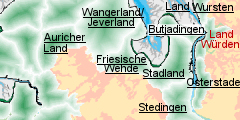
Delimitation: |
River Weser, river Lune,
Bremerhaven (State of Bremen) neighbouring entity, Osterstade |
|
Size: |
Approx. 30 km² |
|
Location
- map: |
Tidal river marsh of
Lower Saxony/ Germany, Western bank of the lower Elbe |
|
Origin of name: |
Not known |
|
Relationship/similarities with other cultural entities: |
Four-post hall house,
building of the villages at first on the river embankment without dyke
protection, river marshes of Osterstade, Stedingen, Stadland |
|
Characteristic elements and
ensembles: |
Four-post hall houses,
settlements on river embankments, dwelling mounds, brickworks, dykes |

2. Geology and geography
2.1 General
The Land Würden is a flat marshland on the western bank of the river Weser.
Next to the river is a slightly higher, 1km wide embankment with sandy,
chalky soil. Between this and the Geest is the Sietland, low lying land,
which is roughly 1 m lower than the embankment. The sediments here are finer
and combined with their high water content, they provided the ideal
conditions for the formation of peatbog. The region is drained by various
artificial sluices, which channel the water into the River Weser. The mouth
of the rivulet Lune was moved in 1985-87. It now flows into the Weser in the
southern part of the Land Würden instead of to the north of it. In contrast
to the low lying land, the embankment and the Geest border have a great
number of trees and bushes.
The Land Würden owes its existence to an affiliation with the lords of
Oldenburg. The area was mortgaged to Bremen citizens in the 14th century,
belonged to Denmark (1667-1773) and came under the Napoleonic occupation.
Only in 1974 was it added to the administrative district of Cuxhaven on the
eastern side of the river. It is now a part of the administrative area of
Loxstedt. However, the church still belongs to the diocese of Oldenburg. The
division of the place of Büttel is a historical oddity: since the Middle
Ages half of it has belonged to the Land Würden, and the other half to
Osterstade.
The Land Würden has no settlement centre, but rather consists of numerous
small settlements, of which Dedesdorf with its former ferry point and one of
two churches is the principal one. The second church is located in Büttel
and belongs to the diocese of Hanover. The largest place in the Land Würden
is Eidewarden with 386 of the total of 1799 inhabitants. The other places
are Maihausen, Overwarfe, Ueterlande, Wiemsdorf and Speckje.
2.2 Present landscape
The Land Würden is characterised by grazing land. It is a very flat
marsh-landscape, from which only a few high trees, churches and a windmill
project. In the north it borders directly on the industrial zones of
Bremerhaven, so that there is a very harsh break between the rural landscape
and the urban structures.
The majority of settlements are located on the embankment of the river
Weser. Normally the houses are built on terpen. The pasture-forms are varied:
there are Hammen and Strengen, which were set up at various times. Numerous
paths, called Helmer, make the fields accessible.
3. Landscape and settlement history
3.1 Prehistoric and Medieval Times
With the ending of the Ice Age the increase in sea-levels increase led to
the dposition of sediments, formation of marshes and ultimately the growth
of peat-bogs. Due to this process older archaeological layers are
considerably below today's surfaces and are only encountered under special
circumstances.
Therefore for the older periods it is necessary to consider the
archaeological information from a wider area. The oldest finds from the
Weser are from the Middle and Late Paleolithic period. The Neolithic period
is represented more fully on the adjoining Geest. In particular the striking
megalithic burial places demonstrate an intensive use of the land. Some
settlement remains found in Loxstedt derive from this time too.
Numerous finds from the Bronze Age, axes, lances, swords, daggers, a rare
ridge helmet, appear to have been deliberately deposited in the Weser. The
discovery of the Late Bronze Age settlement of Rodenkirchen-Hahnenknopp mill
was a sensational piece of luck. It originated in the 10th/9th century BC
and was covered by massive sedimentation layers. It remained in use until
the pre-Roman Iron Age. Despite periodic flooding the settlement appears to
have survived for a long period, but continuing sea-level rises eventually
led to its abandonment.
On the adjoining Geest, in the district of Loxstedt, a settlement was
excavated which was continuously inhabited from the 1st to the 9th/10th
century AD and is probably the direct precursor of today's village. On the
same Geest island, so-called Celtic fields can be traced, an Iron Age field
form which is wide-spread from Denmark via the Netherlands to Great Britain.
Somewhat further to the south, settlement activity begins in the first
centuries AD in the marsh as well. Whether the situation was similar in the
Land Würden, or only the higher areas of land were used extensively cannot
be determined at the moment.
After an interruption in settlement-building, new settlements apparently
commenced in the early Middle Ages. In as far as place-name evidence and
written sources enable us to make any statements, the settlers appear to
have been Frisians. The road to the oldest church in the region in Barmstedt
led from the west across the Weser through the Land Würden to the church on
the Geest. Today this road is still called Freesenweg. On the Geest, too,
there were villages with a Frisian population, as has been proven for Nesse
(community of Loxstedt).
Dedesdorf and Eidewarden, too, used to lie the middle of parish land, but
due to the loss of land to the Weser, they are now on the edge of their
arable and grazing areas. The Land Würden, with its principal settlement at
Dedesdorf, belonged to the Dukedom of Oldenburg from at least the 13th
century AD. How this happened has not yet been clarified by scholars;
according to legend it was mortgaged for a dowry and was not redeemed.
In the 11th century the building of dykes began in the Land Würden. At first
these only served as a protection for farm land, because the settlements
were built on mounds. Today’s houses are also on mounds, some of which may
have a medieval core.
There are no important castles in the area. The names Schwingenburg and the
“Burg” (the Castle) close to Oldendorf have not been verified as referring
to actual fortifications. The building of castles, a characteristic of
lordly rule, did not occur in this area of Oldenburg because of the powerful
position of the town of Bremen, which feared for the loss of freedom of
shipping on the Weser.
Based on the interpretation of written sources, Overwarfe is a somewhat
younger settlement, the mound is high, (in 1717 and 1825 it was above the
height of the floods), but 3m below the ground there was a clay floor, which
according to Ramsauer testifies to a greater age for the settlement place.
The St. Laurentius Church of Dedesdorf is the oldest building in the region.
In the written sources it was mentioned for the first time around 1150, the
oldest surviving parts are from the second half of the 13th century. In 1838
the pulpit was renewed and in 1870 the church tower was replaced by a new
one. The organ, which is a point of attraction for many people, was built by
the well-known organ builder Arp Schnitger in 1697/98.
3.2 Early Modern Times
The storm floods which left their mark on the Land Würden were those of 1717
and 1825. Many houses on the old dwelling mounds survived above the floods,
but those in low-lying areas flooded, the fields were salinated and the
ground waterlogged. After the Christmas flood of 1717 the dykes were
difficult to repair. A feature of dyke building is their constant increase
in height. Despite this, on the western bank of the Weser, arable land was
lost repeatedly and the hinterland became more intensively cultivated. The
moorland of the Geest has been drained and cultivated since the 18th century.
The agriculture in the Land Würden changed in the 16th/17th century, with a
decrease of tillage in favour of pasturage. Traders from Bremen bought
cattle, for instance from Jutland, and had them graze in the marshes until
they reached maturity for slaughter.
In the 18th century the changes to the route of the Weser began, from a
freely meandering river with shallows into a waterway. By means of groynes (vertical
structures diagonal to the banks) the flow of water was increased in the
middle of the river and thus the silting-up of the waterway was prevented.
Since the 19th century there has been a step-by-step expansion of the Weser
into a waterway with a depth of 14 m. Further deepening is planned.
There are only very few architectural remains from the early Modern Times
surviving. Indiek 20 is an isolated farm belonging to Büttel which has an
inner post-structure from 1599. As the house contains wood from trees felled
in 1653 it could well have been rebuilt after a predecessor was destroyed in
the Thirty Years War. Part of a house in Wiemersdorf dates to 1638. A rare
decoration of fanlike rosettes, that is otherwise usual in the upper Weser
area, decorates the gable. The two-storey storage house made of bricks in
Büttel is completely without decoration. The ground plan and the angle of
inclination of the saddle roof suggest that it is very old.
The tombstones in the churchyard of Dedesdorf form an important group of
monuments. They were probably made in Bremen of non-local sandstone. Hence
every dead person has got their own stone and virtually no additions were
made. They are proof of the wealth of the inhabitants of the place at that
time.
3.3 Modern Times
Today the Weser is dammed by the new Weser weir near Bremen. There the
difference between the low and the high tide is 4m (0.19m prior to the
expansion). Weirs near Hunte, Lesum und Ochtum prevent extreme water levels
in the tributaries. The dyke-line is fixed and thus the land-water-border is
constant.
The Lune Bank, which was surrounded by dykes in the 19th century, was not
settled. However there was a shepherd’s house there.
The Lower Weser Railway (Niederweserbahn), which linked the eastern
marshland from 1911, was closed to passenger traffic in 1931. After the
Second World War it was opened again before it was closed for good in 1964.
This marked the end of this line.
In the 19th century numerous buildings were erected which today characterise
the cultural landscape. They are built with four posts at the gable end, and
the ground floor ceilings are on the same level as the eaves. They have half
hipped roofs with characteristic windows and have small round windows in the
gable. A building of this type has been preserved in Ueterlande (2
Olderburger Strasse). The barns, too, were prestigiously built. Typically
they are built parallel to the road with barns at right-angles to it.
Examples of the architecture of the mid 19th century are found in Overwarfe
(25 and 50 Warftenstrasse) The house 5 Minneörterstrasse in Wiemsdorf is
from the end of the 19th century.
The customs house from the period of the Napoleonic occupation is an
architectural oddity. During the Continental System from 1811-1813 it served
as a custom post in Dedesdorf. Later the house was dismantled and rebuilt
behind the dyke. A further building without agricultural significance has
also been preserved, the village-school of Büttel (around 1900). The
school-system goes back to the 16th/17th century.
The windmill in Dedesdorf, actually situated in Oldendorf, is a lordly mill
and was mentioned in 1650 for the first time. At that time it was leased and
the people of the Land Würden were forced to grind their corn there. In 1847
the old post-mill was sold on the condition that a new mill was to be built.
Today’s mill from 1847 is a two-storey gallery windmill with tail and sail
wings. The community of Loxstedt is attempting to sell the windmill complex.
In the 19th century there were a number of brickworks on the lower Weser.
They supplied Bremen and the new harbour-town of Bremerhaven and the places
which were there before it. There were also brickworks in Wiemersdorf, at
the Overwarf sluice and at the Büttel sluice. The marshy soil (clay) served
as a basic material and peat from the moor areas on the river Lune was used
as fuel. The peat could be transported by ship to the flourishing towns at a
reasonable price, just as could the bricks from the factory.
From 1885 a steam boat operated the ferry connection which had existed since
the Middle Ages. In 2004 it was discontinued. The harbour of Dedesdorf was
abandoned in the 1980s.
4. Modern development and planning
4.1 Land use
The region of the Land Würden is characterised by intensive meadowland-use.
The decrease in the number of farms is echoed by an increase in size of the
remaining examples. Fisheries on the Weser have fallen off and does not
exist in the Land Würden any longer. The northern dyke foreland is protected
as a bird sanctuary. Stotel Moor and Königsmoor close to Schwengen are
nature reserves.
Since the early Modern Times the dyke-line has only changed a little. The
bends in the old dyke which had originated from destroyed segments being
altered have been straightened by modern dyke building-measures. The old
steeper dyke-profile can still be seen in one segment at “Auf der Jührde” in
Ueterlande. The rear dyke on the low lying land, called Landwehr, is no
longer necessary due to today's continuous dyke line.
4.2 Settlement development
In 2006 1.799 people lived in the Land Würden (16.197 in the entire
community of Loxstedt). The growth of the community is greatest on the
Geest. There has been a town-to-country movement. A further expansion of the
town of Bremerhaven has stopped at the moment at the borders of the federal
states of Bremen and Lower Saxony. An expansion of housing and industrial
areas is only relevant to the area on the Geest, but there too no further
expansion is anticipated
The price of property in the Land Würden is very moderate. In the northern
area the vicinity to the airport of Luneort in the city zone of Bremerhaven
effects the area.
The flat countryside appeals greatly to bicycle tourists, and Dedesdorf
still has a role as a centre of attraction in the Land Würden. The organ in
the local church attracts visitors from afar, because it was made by Arp
Schnittger, who is famous in the whole of North Germany. The organ was
restored in 1998.
The society “Historic Centre Dedesdorf-Eidewarden” has established itself at
the so-called “Hochzeitsmühle” (Wedding-Mill) in Dedesdorf. On the one hand
the society consists of a network, on the other it organises events around
the mill.
The part of the Lune Bank, which has been surrounded by dykes, is an EU-bird
sanctuary. The offshore mud flat-surfaces are to be made nature conservation
areas and offer restricted tourist facilities.
4.3 Industry and energy
In the Middle Ages only church towers projected above this level landscape
with its open skies. In the early Modern Times windmills were added,
although there was only one in the Land Würden. Nowadays there are many
technical constructions which have altered the look of the entity. Beside
the wind turbines close to Stotel, there are the high tension lines which
run from north to south. Opposite the Land Würden there is the nuclear power
station of Unterweser with its transformer station and further wind turbines.
Loxstedt is planned as a location for harbour-orientated industrial estates.
In the Land Würden only a small part of the Lune Bank (200 hectare) is
included in the plan for it, the other part will remain a protected area.
4.4 Infrastructure
The use of the waterways in the Land Würden has largely come to a
standstill. After the closing of the ferry-service Dedesdorf-Kleinensiel,
the river Weser does not function as a connecting route any longer.
The Land Würden is connected by the motorway A 27 (Bremen-Bremerhaven)
running along to the east and by the federal road B 437 running on its
southern border and with the western bank of the Weser by the Weser-tunnel.
This link, which has existed since 2004, has not yet led to an economic
upswing in the region. However, the number of daily Weser crossings has
increased, so that greater integration of the eastern and western bank of
the Weser can be seen. Now the eastern bank has improved access to the
cultural and commercial possibilities of the town of Bremerhaven. As far as
the small region of the Land Würden is concerned the tunnel is a
disadvantage. The Weser-tunnel attracts further transit-traffic. This effect
will increase even more, if the motorway A 22 is built. It is planned as a
relief for Greater Hamburg and Bremen and should at the same time assist the
structurally weak regions of Cuxhaven, Bremerhaven/Bremen, Oldenburg and the
Emsland by giving a better linkage to the major road-network.
Public transport is completely orientated towards the metropolis of
Bremerhaven.
5. Legal and spatial planning aspects
In matters of regional planning the communities are subject to the Regional
Planning Programme of Lower Saxony and the plans of the communities
concerning town and country planning and use of land. In addition the
regional development for Bremen-Bremerhaven and the regional development
concept for the sea off Lower Saxony’s coast have to be taken into
consideration.
Although the Land Würden is located on the developing axis
Bremen-Bremerhaven, until now the region has suffered from negative
consequences: the construction of the Weser-tunnel and as a result the
closing of the ferry-service to Kleinsiel.
At present (2006) the project “Integrated Rural Development Concept –
Wesermünde-South” is starting. Here people living in the communities
Schiffdorf, Beversedt, Hagen and Loxstedt are to take part in the
development of their region. They are also to be the drivers of this
development. The Land Würden is a part of Loxstedt and thus part of its
planning area. The new master plan for coastal protection has not been
published yet.
Proceedings have recently begun to protect the mud-flats off the nature
reserve of Lune Bank.
6. Vulnerabilities
6.1 Spatial planning
Spatial plans for the area could pose a danger for the cultural
landscape unless they take historic structures and characteristic features
into consideration and integrate them into future concepts.
6.2 Agriculture
The adoption of the changed production conditions in agriculture,
resulting in the reduction of farm numbers and the re-parcelling of land
which is planned for 2006 - 2010, will have significant consequences on the
present fieldscape, farm buildings and their heritage value.
6.3 Tourism
In spite of its rural character, access to the Land Würden by car is
simple but is more difficult by public transport. The closing of the
ferry-service Kleinensiel-Dedesdorf has had a negative effect on Dedesdorf
as a tourist attraction.
6.4 Industry and energy
The nuclear power station of Unterweser, electricity pylons and wind
turbines have a considerable visual impact on the wider landscape.
6.5 Infrastructure
The area is surrounded by constructions associated with transport which
have a negative visual impact on the wider landscape. The ship traffic on
the Weser has probably the least disturbing effect in this respect but the
motorway and the Weser-tunnel, which is to be developed into a motorway, is
more problematic and Bremen airport, which is located on the Lune Bank, is a
further cause of disturbance. Further planned deepening of the Weser could
destroy archaeological remains in the marine environment.
6.6 Natural processes
The settlement of Crenesse close to Dedesdorf, which dates to the early
Middle Ages and was abandoned during the Middle Ages, is endangered by
erosion by the Weser.
7. Potentials
7.1 Spatial planning
The planning of the “Integrated Rural Development Concept” and the
association Historic Centre Dedesdorf-Eidewarden represents a new type of
public involvement with the cultural heritage although its potential remains
to be seen.
7.2 Nature conservation
Management of land for nature conservation offers opportunities for the
beneficial management of the cultural heritage through the adoption of an
integrated management planning approach.
7.3 Tourism
The direct proximity of the Land Würden to Bremerhaven (116.000
inhabitants) offers numerous opportunities, for exploitation of the cultural
landscape – including its agricultural use – for recreation close to the
city. There are opportunities for establishing self-guided routes for
cycling, hiking and riding which integrate the cultural heritage and natural
environment. The Land Würden also has a name which can be developed into a
brand to help market the area for tourism and to strengthen the sense of
place. The location of Dedesdorf and Eidwarden directly on the Weser is
attractive and the place continues to attract tourists, despite the closing
of the ferry.
8. Sources
Author: Julian Subbert
AUST, 1976
Hans Aust, Forschungsgeschichte des westlichen Elbe-Weser-Dreiecks.
Landkreis Wesermünde, Kreis Land Hadeln, Stadt Cuxhaven.
In: Führer zu vor- und frühgeschichtlichen Denkmälern. Bd. 29. Das
Elbe-Weser-Dreieck I Einführende Aufsätze. 1976:9-29.
BAHRENBERG U. A., 1999
Gerhard Bahrenberg, Angela Hartrampf, Klaus-Martin Hesse und Gerd König, Zur
sozioökonomischen Situation im Unterweserraum.
In: Michael Schirmer und Bastian Schuchardt (Hrsg.), Die Unterweserregion
als Natur- Lebens- und Wirtschaftsraum. Eine querschnittsorientierte
Zusammenfassung. Bremer Beiträge zur Geographie und Raumplanung, Heft 35,
1999:153-178.
BEHRE, 1995
Karl-Ernst Behre, Kleine historische Landeskunde des Elbe-Weser-Raumes. In:
In: Hans-Eckhard Dannenberg und Heinz-Joachim Schulze (Hrsg.), Geschichte
des Landes zwischen Elbe und Weser. Bd. I, Vor- und Frühgeschichte.
1995:1-59.
BICKELMANN, 1999
Hartmut Bickelmann, Bremerhaven und die Lune, Räumliche und wirtschaftliche
Beziehungen zwischen Stadt und Umland im 19. und 20. Jahrhundert.
In: Jahrbuch der Männer vom Morgenstern 77/78, 1998/99:121-209.
BÖKER, 1997
Doris Böker, Landkreis Cuxhaven. Baudenkmale in Niedersachsen, Bd. 19, 1997.
HOFFMANN, 1986
Hans-Christoph Hoffmann, Bremen, Bremerhaven und das nördliche
Niedersachsen. Kultur, Geschichte, Landschaft zwischen Unterweser und Elbe.
DuMont-Kunstreiseführer. Köln: 1986.
LIEBERMAN & MAI, 1999
Nicole von Lieberman und Stephan Mai, Küstenschutz an der Unterweser vor dem
Hintergrund von Naturraum und Nutzung.
In: Michael Schirmer und Bastian Schuchardt (Hrsg.), Die Unterweserregion
als Natur- Lebens- und Wirtschaftsraum. Eine querschnittsorientierte
Zusammenfassung. Bremer Beiträge zur Geographie und Raumplanung, Heft 35,
1999:109-127.
RAMSAUER, 1991
Daniel Ramsauer, Chronik von Landwührden und der Kirchengemeinde Dedesdorf.
Um Bildmaterial erweiterte Neuauflage von 1925. Bremerhaven: 1991² (19251).
SCHMID, 1995
Peter Schmid, Archäologische Ergebnisse zur Siedlungs- und Wirtschaftsweise
in der Marsch.
In: Hans-Eckhard Dannenberg und Heinz-Joachim Schulze (Hrsg.), Geschichte
des Landes zwischen Elbe und Weser. Bd. I, Vor- und Frühgeschichte.
1995:221-250.
SINDOWSKI, 1979
Karl-Heinz Sindowski, Zwischen Jadebusen und Unterelbe. Sammlung geologische
Führer, Bd. 66, 1979.
ZIMMERMANN, 2001
H. W. Zimmermann, Loxstedt.
In: Hoops Reallexikon der germanischen Altertumskunde, Bd. 18, 2001:629-633.
|