|
1. Overview
|
Name: |
Land Wursten |
|
Delimitation: |
Bordered to the north by
the town of Cuxhaven, to the west by the Wadden Sea, to the south by
the town of Bremerhaven and to the east by the Geest ridge “Hohe
Lieth“. |
|
Size: |
Samtgemeinde (joint community) Land Wursten: 117 km², 9730 inhabitants.
Area under investigation: approx. 200-250 km² |
|
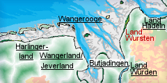
Location
- map: |
Part of the national park
„Wurster Wattenmeer“, Lower Saxony, Germany. |
|
Origin of name: |
This name stems from the
lower German word Wursaten or Wurtsasses meaning “people sitting on
dwelling mounds”. |
|
Relationship/similarities with other cultural entities: |
Zweiständerhaus (two
pillared house), nucleated villages, Wurtendörfer (dwelling mound
villages) (Emden, Jadebusen), marsh areas along the coast, Geest
areas. |
|
Characteristic elements and
ensembles: |
Dwelling-mounds, stone
churches, marsh landscape, dykes |

2. Geology and geography
2.1 General
The cultural landscape of Land Wursten lies in the administrative district
of Cuxhaven. It consists of the joint community of Land Wursten and a
coastal strip which reaches from the town of Cuxhaven in the north to the
town of Bremerhaven in the south. The joint community (formed 1974) itself
consists of 7 communities: Cappel, Dorum, Midlum, Misselwarden, Mulsum,
Padingbüttel and Wremen. The marsh landscape lies in the western part of the
so-called Elbe-Weser triangle. The area has a length of ca. 30 km and a
breadth of 4 to 9 km. To the west the area under investigation is bordered
by the tidal flat, to the north by the North Sea coast and to the east by
the Geest ridges “Hohe Lieth“ and “Wurster Heide“. They run parallel to the
“green coastal road” which leads from Cuxhaven to Bremerhaven. In the south,
the area around Bremerhaven forms the border.
The prominent end moraine “Hohe Lieth“ developed during the penultimate cold
stage (Saale-Kaltzeit) when the ice was pushing into Northern Germany.
Today’s coastal line developed about 5.500 B.C. during a general sea-level
rise (the Flanders Transgression). Several advances and retreats of the sea
(transgressions and regressions) followed, each of which left sedimentary
deposits.
2.2 Present landscape
In the coastal area, the Neue Marsch (new marsh) is sited on the coast, with
the Alte Marsch (old marsh) sited further inland. The Neue Marsch is higher
than the Alte Marsch; the soils are sandier and therefore better for
agriculture. The Alte Marsch is lower-lying, has a more clayey ground, is
wetter and therefore less well suited for agriculture. Presently this area
is thinly inhabited and used mainly for pasture. The whole area is sparsely
wooded, only in the north and east can a few enclosed woodlands be found. In
order to avoid the continuous flooding of the wet marsh land the 20 km long
Grauwall channel was built.
In front of the Land Wursten lies the Wurster Watt, which is also part of
the National park Niedersächsisches Wattenmeer. In total there are three
national parks in the tidal flats; these were designated between 1985 and
1990, and are located in Schleswig Holstein, Lower Saxony and Hamburg. The
protected area stretches from the East Frisian islands to Sylt.
3. Landscape and settlement history
3.1 Prehistoric and Medieval Times
Worsatia is mentioned for the first time in the year 1203. This name stems
from the lower German word Wursaten or Wurtsasses which describes the
inhabitants of the area as “people sitting on dwelling mounds”.
The people of the Land Wursten had been using dwelling mounds since the
Stone Age. There is ample archaeological evidence for Stone Age occupation:
including the site of a camping ground near Nordholz, a stone tool
production site near Midlum, the dense concentration of stone tools at the
site of Neuenwalde, Neolithic settlements near Langen and Midlum as well as
other finds. The sediments of the river marshes might further contain older
Palaeolithic evidence. Between Imsum and Langen pottery sherds and flint
tools of the late Bronze Age and early Iron Age have also been found.
The oldest recorded settlement sites in the marsh did not lie on the
elevated ground but were level surface settlements (Alsum, Feddersen Wierde,
Dorum, Mulsum and others). They were built during the time when the sea
retreated from the coast around 100 B.C and existed until 100 A.D. The sea
level subsequently rose again and the inhabitants of the first and second
century A.D. responded to this environmental change by gradually raising the
level of their dwelling places. They heaped up earth or dung and other
waste, forming the Wurten or dwelling mounds. Over time these dwelling
mounds got higher and higher and in some areas joined each other to create
the Dorfwurten (villages on settlement mounds).
One of these dwelling mounds is the well known archaeological site of the
Feddersen Wierde. Archaeological excavations here were able to shed light on
the history of this settlement which lasted from the first century B.C until
the 5th century A.D. In the overall area, in the course of the 4th and 5th
century A.D, a decline in the numbers and size of settlements can be
observed for the complete Elbe-Weser triangle.
Burials provide some information about the expectations of an afterlife for
this period. An important site is the burial ground of Fallward with its
numerous well preserved wooden finds such as the famous ”marsh throne”.
For the 7th and 8th century A.D. increased settlement activities are
documented. The earliest settlements founded during this time were the
Wurten Wremen, Misselwarden and Mulsumer Wierde. During the 9th and 10th
centuries other areas of the new marsh were also settled, e.g. Cappel und
Paddingbüttel. It is also known that in the 9th century ships were sailing
from the Elbe and Weser to Scandinavia after Ansgar, the bishop of Bremen,
began with the proselytisation of Scandinavia by 830 A.D.
During the 12th century the process of dyke construction began and the
building of dwelling mounds lost its importance. The first dykes seem to
have been summer dykes encircling the settlements and their agricultural
areas. Some of these medieval dykes are still preserved. Only during the
17th century was the continuous process of change along the coast stopped by
the construction of today’s coastal dyke.
The churches with their massive stone walls provided yet further protection
against both storm tides and enemies. The stones came from the nearby Geest,
sandstone from the Weser or tuff from the Eifel was used as well. The
parishes of the Land Wursten were prosperous and this is reflected in the
development of their own architectural style. The well preserved church
buildings from the 12th to the 14th century in Imsum (Ochsenturm), Wremen,
Mulsum, Dorum, Spieka, Misselwarden, Paddingbüttel and Midlum are good
examples for this.
3.2 Early Modern Times
Towards the end of the Hanseatic League, the long distance roads from Stade
and Bremen, which ran east and south respectively, were in place. The south
and west of the area could be easily reached by ship via the Elbe and the
Weser.
Following the Christian proselytisation of the area, the Land Wursten used
to be a self-governed Bauernrepublik (farmers’ republic). For a long time
there were conflicts with the archbishopric of Bremen until the Land Wursten
lost its independence in 1525 and became part of Bremen.
During the Thirty Year’s War (1618 - 1648) Wursten was occupied by
Protestant and Imperial forces. Sweden became one of the most powerful
political forces of the 17th century in the North Sea region and followed an
aggressive conquest policy. Whilst the Thirty Year’s War still raged, the
Swedish moved into Wursten (1645). After the Treaty of Westphalia (1648),
Hither Pomerania, to the east of the Oder, the districts of Poel and
Neukloster, the town of Wismar as well as the monasteries of Bremen and
Verden all belonged to Sweden. But Wursten was not to be part of Sweden for
long. During the “Big Northern War” (1700 – 1721) for a short time the Land
Wursten belonged to Denmark (1712 – 1715) and later to the electorate of
Hanover.
The Land Wursten is largely dominated by closed Haufendörfer (nucleated or
scattered villages[U1]) and more dispersed villages, as well as the
Wurtendörfer (villages on dwelling mounds). Such Wurtendörfer are also
typical for the northern part of Butjadingen, the Wangerland north of
Wilhelmshaven and for the area north of Emden. The most common farming
building is the Niederdeutsche Hallenhaus (lower German hall house) or
Niedersachsenhaus (Lower Saxony house).
3.3 Modern Times
The beginning of the modern period in the Land Wursten is characterised by
the so-called French Time (1807-1815), this was not however long-lasting.
After the Congress of Vienna (1815) Wursten was assigned to the kingdom of
Hanover. Since 1866 the territories of Hanover belonged to Prussia.
By 1812 there were still no paved roads in the Land Wursten. Only with the
building of the Hannoversche Chaussee, the Braunschweigische Heerstraße as
well as the Oldenburgische Staatsweg in 1863, was a connection between
Cuxhaven and Bremerhaven achieved. Just 30 years later, other small country
roads were added to the road network in the Land Wursten. Thus, when the
road network of 1893 is compared with that of today, the only recent
addition is the Autobahn.
The train connection from Bremerhaven to Bremen was opened in 1862, with
other connections to Mecklenburg (1865) and the Netherlands (1865) following
soon after. By 1881 Harburg, Buxtehude and Stade could be reached from
Cuxhaven by train. Almost 50 years later (1896) the train route through the
Land Wursten was opened. Soon after that Bremervörde (1898) and Bremerhaven
(1899) were connected to the train network of Stade.
After the downfall of the Third Reich the Land Wursten was integrated into
the former administrative district of Stade in the federal state of Lower
Saxony. In 1978 the administrative district of Stade was fused with the old
district of Lüneburg and became the administrative district of Lüneburg. The
district government is also sited here. The districts were dissolved in
2005.
For a long time Cuxhaven was of considerable importance as the nation’s main
fishing centre. This situation changed during the last century, not least
because of the International Maritime Law Conventions. The biggest economic
importance in Cuxhaven and the Land Wursten now lies with agriculture,
maritime industry and tourism.
4. Modern development and planning
The economic development in the Elbe-Weser region is strongly influenced by
the two Main Order Centres of Bremen and Hamburg, the two biggest Hanseatic
and port cities in Germany.
During the second half of this year the BBR (Bundesamt für Bauwesen und
Raumordnung/ federal office for building and land use planning) has
introduced three new models for the land use planning which were developed
by the federal government after its comments on the land use report 2005.
These models could also be of importance to Wursten. The first item is the
“Contribution to the economic growth“. Bordering on the Land Wursten there
are two “Sites of metropolitan function” (Cuxhaven and Bremerhaven). These
have potential for further growth which will be directly exploited. Another
point of focus is the „taking precautions to secure existence”. Considering
the prognosis of population development until 2050, it is to be expected
that the population in the rural areas will decrease while the metropolitan
regions will continue to grow. Nevertheless the official Institutions and
Services of General Interest should to be preserved or at least stay within
reach. The third point is the “Management of land use” for which the
regional planning will increasingly have to take over the design and
development functions. In Wursten there are substantial ground water
resources which need to be protected. The same goes for the agriculturally
characterised historic cultural landscape.
In the Land Wursten there are several institutions which deal primarily with
regional development, such as the Stadtplanungsamt (city planning council
of) Bremerhaven, the Kreisentwicklungsreferat of the Landkreis or des
Landkreises (regional development department of the district of) Cuxhaven,
the information centre Nationalpark Dorum and others.
4.1 Land use
The agricultural landscapes of Lower Saxony can be divided into marsh lands,
valley meadows, Geest areas, loess ground in the foothills and loess hills
in the Oberharz Mountains. Most of the ground is taken up by valley meadows,
peatland Geest and Geest flats.
In Wursten there are some arable marshes in the western area and valley
meadows and peatland Geest in the most northern part of the area. But the
main part of the area under investigation is made up of grazing marshes in
the west and south and of Geest flats in the east and north.
Even though agriculture has declined in the area due to outside influences,
it is still of considerable importance in the Land Wursten. In the marshes
wheat, corn and rape are cultivated. On the Geest rye, corn, rape and
triticale (a cross between wheat and rye) are grown. Rye thrives on the
light sandy soils because it is hardy and undemanding. Rye as well as corn
can be used in the production of biogas and bio- ethanol. It is hoped that
future breeds may make it possible to reduce the use of pesticides in tits
cultivation. Today’s yields on the marshes already amount to approx. 85
cwt/hectare. The yields have increased strongly during the last years due to
changes in fertilisation, modifications to arable practise and new breeds of
plants. The yields from the grazing marshes, valley meadows and Geest are
significantly lower. The grazing marshes largely support dairy cattle.
In Wursten the share of the population employed in agriculture is reciprocal
to the population density. Thus in the less densely settled area in the west
about 11% of the population are employed in agriculture, in the eastern part
(around the Autobahn) less than 8% are in agriculture, in the northern part
(Cuxhaven) less than 5 % and in the most densely settled area in and around
Bremerhaven less than 2 % are employed in agriculture (figures for the year
1987).
4.2 Settlement development
The urban growth of Lower Saxony has been analysed for the years from 1871
up to the regional reformation of 1972 and then further on until 1993. In
Bremen and Hamburg the population has doubled between 1821 and 1871. In
Cuxhaven on the other hand the population only increased by about 17%.
Because of the situation of Cuxhaven, on the outskirts of the metropolitan
regions the population is stagnating or even declining.
In the BBR’s analysis of the trends of spatial development from June 2005
the Land Wursten belongs to the regions where the population and employment
development are characterised by a slight decrease because of its location
near the growth centre of Bremen.
According to the regional report for northern Germany 2005 (NIW) the
population density in the western part of the Land Wursten is very sparse,
with figures of between 50 and 100 people per km². Further to the east
towards the Autobahn the density reaches 100 – 200 people/ km². In the
south, in and around the town of Bremerhaven the density is highest with
more than 500 people/ km², and in and around Cuxhaven the density goes up to
300-500 people/ km². In 2004 approximately 50% of the workers in Bremerhaven
commuted to the town, the corresponding figure for Cuxhaven is between 10%
and 25%..
In the Land Wursten it is possible to study at the national maritime academy
or at the Hochschule Bremerhaven. Furthermore within the commuting radius
there are the University of Hamburg, the technical colleges of Buxtehude
(less than 1000 students), Elsfleth (less than 1000) and Oldenburg
(1000-5000) as well as the state-approved FH Ottersberg (less than 1000). In
the region in and around Cuxhaven and Bremerhaven there are 7 secondary
schools.
In this rural area there is a large number of ecclesiastic and regional
education centres. The cultural life is characterised by museums and local
clubs. In Bremerhaven, Bremen and Hamburg there are several theatres, whilst
in Cuxhaven there is a Niederdeutsche Bühne (lower German theatre). The
nearest national theatres are situated west of the Weser, in Oldenburg and
Wilhelmshaven.
Wursten belongs to the Association of Stade (Landschaftsverband Stade). It
is part of the national park “Wurster Wattenmeer“ on the coast of Cuxhaven
and the lower Elbe.
The State Office of Lower Saxony for statistics did a survey on the booked
beds for the years between 1984 and 1994. According to this survey the
overnight stays have almost doubled within those 10 years (a rise of 95%).
For the time between 1987 and 1998 another distinct rise in the numbers of
overnight stays was observed. Therefore the Land Wursten occupies, together
with the coast of Eastern Frisia and the Emsland/der Grafschaft Bentheim,
one of the pole positions of German holiday regions.
One possible reason for this development is the large number of tourist
attractions: the whole Elbe-Weser region is sporting over 100 museums, e.g.
in Bremerhaven there is the Historical Museum, the Collection of School
History, the Supplies’ and Traffic Museum; in Cuxhaven the Castle
Ritzebüttel; in Nordholz the Aeronauticum, in Neuenwalde the Museum for
Local History and the monastery, the open air folklore museum Speckenbüttel,
the prehistoric trail in Sievern, various archives, the lovely churches of
Wremen, Mulsum, Dorum, Cappel as well as the Kurverwaltungen (health resort
administrations of the) Land Wursten and of Cuxhaven.
Some of the museums and institutions deal explicitly with the characteristic
local traits, e.g. the Museum for Fishing in the Tidal Flat in Wremen, the
information centre Nationalpark Niedersächsisches Wattenmeer Land Wursten in
Dorum and Cuxhaven, the Dike Museum of Lower Saxony in Dorum, the Sea Shell
Museum in Nordholz, the Wreck Museum in Cuxhaven, the emigration exhibitions
in Bremerhaven and Cuxhaven and in Bremerhaven die SSW Ferry and Specialised
Ship Building Bremerhaven, the Alfred-Wegener Institute for Polar- and
Marine Research, Schaufenster Fischereihafen (showcase fishing harbour), the
Atlanticum Forum Fischbahnhof, the museum ship FMS Gera, the Hanseatic Cog
Shipyard, the light house of Cuxhaven and the German Shipping Museum.
4.3 Industry and energy
In Lower Saxony there are numerous industrial plants which (except for the
catchment areas of Hamburg and Bremen) are concentrated mainly in the south
of the federal state. The Land Wursten lies between the catchment areas of
the principal industrial areas of Hamburg and Bremen and is not
industrialised in itself.
Cuxhaven (5,000 employees) and Bremerhaven (15,000 employees) can be
regarded as smaller industrial sites. The economy in the district of
Cuxhaven consists of small and middle-sized businesses and the harbour
economy. The Europakai in Cuxhaven has already been converted into a
multi-purpose trans-shipment centre.
The Land Wursten is connected via the gas pipeline
Cuxhaven-Bremerhaven-Osterholz-Scharmbeck with the subterranean gasholder of
Bremen-Lesum. In the coastal region of the Elbe-Weser triangle the number of
wind parks increases, like those of the SG Nordholz in the districts
Cappel-Neufeld and Spieka-Neufeld.
4.4 Infrastructure
The Land Wursten is crossed by the Autobahn A-27 which links Cuxhaven and
Bremen. Close to the Autobahn there is also the Grüne Küstenstraße (green
coastal road) which follows a similar route but is more attractive for
tourists and local traffic. The A-1 from Bremen towards Hamburg has already
been completed between 1935 and 1941. There is no further Autobahn
connection but the coastal Autobahn A-22 is already being planned.
In 1993 the first survey of the annual average number of vehicles using the
Autobahn and federal roads on a daily basis was conducted with an average of
about 10,000 vehicles per day. On the Autobahn between Bremen and
Bremerhaven there were as many as 50,000 cars per day. Comparable numbers
are found on the Autobahn A-1 from Bremen to Hamburg. Due to the low-levels
of traffic, the other roads in the area have not been included in the
survey. The business locations in the area (Cuxhaven and Bremerhaven) can
easily be reached by the federal long distance roads.
Today the Cuxhaven-Bremerhaven railway line is a light railway which is
still in regular service. The lines from Cuxhaven via Stade to Hamburg and
those from Bremerhaven to Bremen towards Osnabrück or Hannover are busier.
In the area of the Land Wursten there are two big harbours (Bremerhaven and
Cuxhaven). Two large federal waterways flow into the North Sea at Cuxhaven:
the the Weser and the Elbe, the Oste and the Kiel Canal are branch off from
the latter.
In the Land Wursten there is one airfield worth mentioning, the former
military airfield of Nordholz-Spieka. Two international airports can be
found at Bremen and Fuhlsbüttel.
5. Legal and spatial planning aspects
The joint community or Samtgemeinde of Land Wursten is subject to the
spatial and land use program of the federal state of Lower Saxony and to the
landscape frame plan and land use plan of that community.
In the Landes-Raumordnungsprogramm (regional planning program) of the
Ministry of the federal state of Lower Saxony, the area between Cuxhaven and
Bremerhaven was supposed to secure the further development of two main focus
areas. Within this framework the town of Bremerhaven was designated as a
High Order Centre with the town of Cuxhaven as a developing focus area.
In 1996 there was no regional cooperation between communal initiatives, nor
any legal basis for regional cooperation. However, the Land Wursten was
integrated into a system of double cooperation with neighbouring federal
states. It was part of the Regional-Entwicklungskonzept (regional
development concept) of Bremen and also within the
Regional-Entwicklungkonzept mit erweitertem Betrachtungsraum (regional
development concept with extended area of interest) of Hamburg.
6. Vulnerabilities
6.1 Agriculture
Due to an intensification of agriculture and the consolidation of farms
during the last century (Hofstrerben – farm dying), there has been a loss of
smaller, less profitable farm businesses. This has been caused by a lack of
opportunities for expansion by smaller businesses and/or the lack of
successors. There is also the possibility of an increasing move towards
monocultures for the purposes of bio ethanol which could have an impact on
the landscape. The enlargement of the remaining farm structures might
eventually result in the destruction of historic features and monocultures.
6.2 Tourism
In Cuxhaven as well as in the small picturesque coastal villages such as
Dorum, there is a threat of mass tourism in the form of day trippers and
short term holiday makers from the nearby congested areas.
6.3 Industry and Energy
Further wind farm projects are planned for the Elbe-Weser triangle and
these are likely to have a visual impact in the area as well as the
potential to impact on buried archaeological remains.
6.4 Economy
Land Wursten is a rural area. According to the Statistikamt Nord the
unemployment rate for the district of Cuxhaven (except Bremerhaven) amounted
to 12,8% in 2005 and a further exodus of the population due to the economic
situation of the area is to be expected. One problem is the coastal location
of the Land Wursten meaning there is only development potential towards the
south and the east into largely distributed markets. The number of
industrial businesses in the Elbe-Weser area has been stagnating for years
and the number of people employed in the manufacturing industry is steadily
declining. This structural change frees more and more of the labour force
but as the opportunity for the creation of new jobs is very slim in most
cases the only option left for people loosing their jobs is to commute or
move to the nearest city. In this way there is a danger that the communities
of the Land Wursten might develop into mere dormitory towns, and
identification with the traditional employment structures of the region
might be lost. In Cuxhaven, the decline in the fishing industry has meant
that the related businesses have also declined. The exodus of labour force
and the declining overseas traffic have decimated the tax yields of the
town. This has led to economy measures and reduced the town’s
attractiveness.
7. Potentials
7.1 Settlement
Rural settlement in the Land Wursten is largely dominated by nucleated
villages and more dispersed villages, as well as the Wurtendörfer (villages
on dwelling mounds). The historic character of many rural villages survives.
The most common agricultural building is the distinct Niederdeutsche
Hallenhaus (lower German hall house) or Niedersachsenhaus (Lower Saxony
house).
7.2 Management of the cultural heritage
The Land Wursten has a rich archaeological heritage, including the well
known excavated site of the Feddersen Wierde. The sediments of the river
marshes might contain Palaeolithic evidence and there is good potential for
waterlogged prehistoric deposits. The dwelling mounds remained the focus for
settlement until dyke construction began in the 12th century; some of the
medieval dykes remain and both structures are highly visible features in the
landscape. Well preserved churches in the Land Wursten parishes have their
own distinct, architectural style and good examples from the 12th to 14th
centuries survive.
7.3 Tourism
The biggest potential in this region can be seen in tourism since the
Land Wursten is a versatile recreation area with a high density of
monuments. The historic villages of Wurtendörfer Dorum, Mulsum and others
are situated like beads on a string and demonstrate impressively the
historical settlement development of the area. In the Land Wursten there are
the seaside resorts of Dorum, Wremen, and Cuxhaven as well as the
family-friendly holiday resorts of Cappel, Midlum, Misselwarden, Mulsum and
Padingbüttel. Cuxhaven is the largest North Sea spa along the coast. Apart
from museums, numerous historic churches and the monastery of Neuenwalde
there are further institutions like dock yards or light houses which have a
distinct maritime character and which can only be experienced here or in the
neighbouring regions. Because the Land Wursten is situated near three
conurbation centres (Hamburg, Bremerhaven, Bremen) it is especially
important as recreational area for people coming for a short holiday. There
is currently a growing demand for „Ferien auf dem Bauernhof“ (farm holidays)
which might offer opportunities for preserving historic farming economies.
7.4 Infrastructure
The nearby seaport of Cuxhaven is of great interest not only to the
residents of the surrounding rural areas but also as an attractive location
to new industries.
7.5 Economy
For the Land Wursten there is development potential in the fields of
tourism, agriculture, food production, biogas, offshore technology and
logistics. The fish-processing industry is an important employer and
recently the trade union „Nahrung, Genuß, Gaststätten“ (food, drink and
tobacco, restaurants) held an experts’ meeting about the future of the
fishing industry in Cuxhaven. The question was what could be done to secure
the existence of the local businesses and what were the roles of marketing
and quality management. It was stated that Cuxhaven as well as Bremerhaven
were both competitive but ought to rely more on shared strengths and
cooperate with each other. It was assumed that the demand for fish is going
to increase and that the customers will be willing to pay higher prices for
better quality.
Modern ways of farming are well represented in the area: in Lower Saxony
there is the highest number of biogas works to be found nationwide,
presently about 500. According to the head of the Landvolk J. Heusmann an
increase in the production of milk in the Elbe-Weser triangle can also to be
expected. Next to agriculture there are other economic businesses providing
employment in this region, e.g. industrial businesses (foundry, metal
packaging, electro recycling) and energy businesses (Energie-Kontor-AG,
refuse incineration heat and a power station, water supply works, sewage
treatment plant). Due to the amount of space available, property for
commercial use can be purchased at low prices.
8. Sources
Author: M. Riebau
Ahlers, J. –G. (2006): Niedersachsen stellt sich vor. In : Land und Forst
Nr. 38, Landwirtschaft und Landleben in Niedersachsen. Zeitschrift, Hrsg.
Landvolk Niedersachsen – Landesbauernverband e. V., Landwirtschaftkammer
Niedersachsen.
Bohmbach, J. (Bearb. 1986): Kolloquium schwedischer und deutscher Historiker
in Stade 1984. Die Bedeutung Norddeutschlands für die Großmacht Schweden im
17. Jh. Stade 1986
Dannenberg, H. – E. und Schulze, H. – J. (Hrsg.): Geschichte des Landes
zwischen Elbe und Weser. Im Auftrag des Landschaftsverbandes der ehem.
Herzogtümer Brmen und Verden. Band I. Vor- und Frühgeschichte. Stade 1995.
Diekmann-Lennartz, (Ch. 2006): Perspektiven gar nicht so schlecht. In : Land
und Forst Nr. 41, Landwirtschaft und Landleben in Niedersachsen.
Zeitschrift, Hrsg. Landvolk Niedersachsen – Landesbauernverband e. V.,
Landwirtschaftkammer Niedersachsen.
Eysholt, A. und Matzen, J. (2004): Zwischen Elbe und Weser. Vielfalt
entdecken im grünen Dreieck. Hrsg. Ev. Bildungszentrum Bad Bederkesa. Bad
Bederkesa 2004.
Heimatverein Midlum und Umgebung e. V., (2002): Midlum, ein Dorf auf der
Geest, umgeben von Marsch und Moor. Chronik. Midlum 2002.
Homepages: SG Land Wursten; Information aus der Forschung des BBR (Bundesamt
für Bauwesen und Raumordnung) Nr. 3 / Juni 2005; BBR Leitbilder und
Konzepte/ Neue Leitbilder in der Raumentwicklung nach dem 30. Juni 2006.
Kunstverlag Bühn Hrsg. (1999): Elbe-Weser-Raum auf dem Weg ins 21. Jh.
München 1999.
Labahn, K. (2006): Vor Ort im Elbe-Weser-Dreieck. In : Land und Forst Nr.
44, Landwirtschaft und Landleben in Niedersachsen. Zeitschrift, Hrsg.
Landvolk Niedersachsen – Landesbauernverband e. V., Landwirtschaftkammer
Niedersachsen.
Lehrke, U. (2006): Auf leichten Böden viele Vorteile. In : Land und Forst
Nr. 37, Landwirtschaft und Landleben in Niedersachsen. Zeitschrift, Hrsg.
Landvolk Niedersachsen – Landesbauernverband e. V., Landwirtschaftkammer
Niedersachsen.
Niedersächsisches Institut für Wirtschaftsforschung, Regionalbericht
Norddeutschland 2005. Hannover 2005.
Niedersächsisches Landesarchiv (2006): 60 J. Niedersachsen. Hintergrundtexte
zur Ausstellung. Textsammlung. O. O.
Riebau, M. (2005): Die schwedische Matrikelkarte von Vorpommern und ihre
Bedeutung für die Erforschung der Bodendenkmäler, dargestellt am Beispiel
der Gebiete um Greifswald-Wusterhusen und der Insel Usedom. In: Beiträge zur
Ur- und Frühgeschichte Mitteleuropas 41. Langenweißbach 2005.
Römisch-Germanisches Zentralmuseum Mainz in Verbindung mit dem
Nordwestdeutschen und dem West- und Süddeutschen Verband für
Altertumsforschung Hrsg. (1976): Führer zu vor- und frühgeschichtlichen
Denkmälern. Band 29. Das Elbe-Weser-Dreieck I. Einführende Aufsätze. Mainz
1976.
Römisch-Germanisches Zentralmuseum Mainz in Verbindung mit dem
Nordwestdeutschen und dem West- und Süddeutschen Verband für
Altertumsforschung Hrsg. (1976): Führer zu vor- und frühgeschichtlichen
Denkmälern. Band 30. Das Elbe-Weser-Dreieck II. Forschungsprobleme -
Exkursionen. Mainz 1976.
Schlüsselburg, B. & Schumann, N. (2000): Hadeln, Wursten und Kehdingen.
Hamburg 2000.
Schmidt, K. und Walter, R. (1990): Erdgeschichte. Berlin 1990.
Schumann, N. (2003): Land Wursten, mit Fotos von B. Ulrich und B.
Schlüsselburg. O.O. 2003.
Seedorf, H. & Meyer, H. – H. (1996): Landeskunde Niedersachsen 2. Natur-und
Kulturgeschichte eines Landes. Niedersachsen als Wirtschaft-und Kulturraum.
Neumünster 1996.
Zeitungsartikel: Sonntagsjournal der Nordsee-Zeitung vom 12. 11.2006, S. 22:
Verzögerung sorgt für Minus; Elbe-Weser Aktuell vom 8. 11.2006, S. 4:
„Chancen müssen genutzt werden“, S. 6: „Chancen brauchen Unterstützung“
|