|
1. Overview
|
Name: |
Neuwerk |
|
Delimitation: |
The island of Neuwerk
lies in the mudflat area of Hamburg. The administrative border is
defined by the line of the Average High Tide (Line des Mittleren
Tidehochwassers: MThw). The surrounding mudflats belong to the
national park Hamburgisches Wattenmeer. |
|
Size: |
The dyked core island comprises an area of ca. 1,2 km² including the
area of the dykes, the areas outside of the dykes lie in the North and
East with an area of ca. 1,8 km². Neuwerk therefore has an overall
size of about three square kilometres. |
|
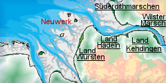
Location
- map: |
The island of Neuwerk is
situated in the mouth of the river Elbe and is the only inhabited
island in the national park Hamburgisches Wattenmeer. It lies about
eight km north of Cuxhaven and 105 km northwest of Hamburg. |
|
Origin of name: |
The first document
mentioning the Island Neuwerk dates back to the year 1286. During this
time the still un-named isle is called “O”, respectively “Nige O”,
which is the Frisian word for island. After the construction of the
defence tower at the beginning of the 14th century the Frisians called
the sandy island “Dat Werk” or “Nige Werk”. Finally the name “Neuwerk”
prevails for the island belonging to Hamburg. |
|
Relationship/similarities with other cultural entities: |
Neuwerk has little in
common with other cultural landscape entities. Place names and
building forms of the Frisian neighbours were not adopted. The
building-style on the island is rather functional, the buildings are
characterised by the simplicity of their forms. A similarity to other
cultural landscape entities can only be seen in the ditch built around
the tower dwelling mound which can be compared to the ditches of the
farmsteads in Hadeln. The defensive tower was built in the style of a
Norman tower house. |
|
Characteristic elements and
ensembles: |
Characteristic features
of Neuwerk are the highly visible brick tower dominating the picture
of the landscape, as well as the ring dyke of the 16th century which
encloses the tower dwelling mound and the original farmsteads,
including much of their farmland. The nature and its unimpeded
development within the national park Hamburgisches Wattenmeer are also
special characteristics of Neuwerk. |

2. Geology and geography
2.1 General
There has been considerable debate about the origin of Neuwerk. Neuwerk,
unlike the neighbouring East Frisian Islands, cannot be a barrier island
because the tidal range in this area reaches about three metres and
therefore forms a strong dynamic current. This makes the development of a
barrier island quite unlikely.
A programme of ground probing has taken place in an attempt to establish its
origin. These have shown the following composition: in a depth of about 20
to 24 metres there are layers from the last ice age. Above those there is a
thin layer of peat and several layers of clay which are up to 2.8 metres
thick and therefore only give evidence for a short period of marsh formation.
On top of these there are marine sedimentations which prove that Neuwerk has
not developed in the course of the sea genesis nor was separated by the
mainland by erosion. The core samples rather show that the isle consists of
a sandy island which had built up during the younger Holocene. It developed
during the alternation of storm tides and dry periods by the formation of
dunes and sediment deposition, gradually moving out of the reach of the
daily tidal range.
2.2 Present landscape
Since its origin, the outline of Neuwerk has changed completely. After the
building of the defence tower in 1310 AD the island kept losing ground to
the medieval storm tides. The construction of the first dyke during the
middle of the 16th century made the island inhabitable and farmable all year
round but later storm tides caused repeating dyke breaks. Today’s outline of
Neuwerk is mainly the result of the shoreline stabilisation which began at
the end of the 18th century and extended until the 1930s. Since then the
care and maintenance of the installations is part of the flood control of
the island.
Neuwerk can only be reached by boat or over the mudflat path from Cuxhaven.
|
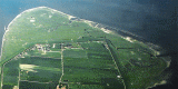
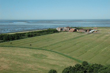
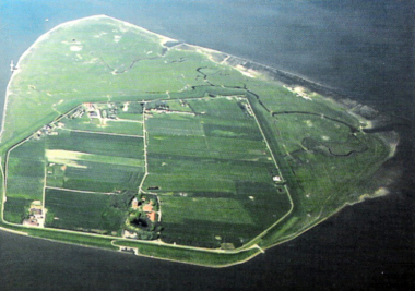 |
| Neuwerk (NEß 2001, 68-69) |
3. Landscape and settlement history
3.1 Prehistoric and Medieval Times
Geologically speaking, Neuwerk is a rather young island which only developed
during the younger Holocene around the 1st century BC. Today’s coast line
only gradually developed at the end of the last ice age. With wide areas of
the present North Sea dry land until 5500 B.C. it can be assumed that
prehistoric foraging groups would have frequented this region. However, any
archaeological sites relating to this phase would be buried beneath
meter-high sediments.
The island of Neuwerk has been used as a fish transhipment point since the
13th century and probably even earlier and is seen as the predecessor of the
fish market of Cuxhaven. The use of Neuwerk as summer pasture is also
documented. In this context the Island „O“ which belonged to the country of
Hadeln was first mentioned in a document of 1286 A.D.. Hadeln was subject to
the sovereignty of the Dukes of Sachsen-Lauenburg, who in 1299 granted
Hamburg the right to build a fortification on the island of „O“ to secure
the mouth of the river Elbe. After a 10 year construction period the square
stone tower was completed, and was manned in 1310 by a 10 men guard detail
from Hamburg. The tower not only grew to be an important daytime navigation
mark but the guard also collected duties from the passing ships for the
maintenance of the tower. The tower, which in its basic structure has
remained almost unchanged, is the oldest building along the coasts of the
trilateral Wadden Sea.
There is no evidence for an island harbour at this date, but it is likely
that smaller ships bringing commodities for daily use to the island had
access via a tideway leading from the east up to the tower.
 |
 |
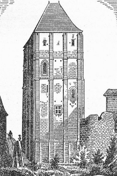
|
Normanic
high rise from the 12th century. The Donjon von Huriel in Bourbonnais.
(Dannmeyer 1952, 61) |
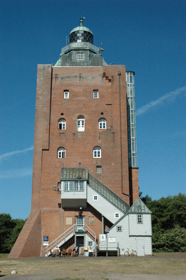
Defensive
tower of the 14th century built in Normanic style. The tower could
only be entered in eight meter height by a rope ladder. (Foto: Dr.
Julia Gebert) |
3.2 Early Modern Times
Until the building of the dykes in the 16th century, people could live all
year round only in the defensive tower, because winter storm tides and high
tides temporarily flooded the remainder of the island. After the completion
of the dyke, the dyked areas could be inhabited all year round and were
leased to three farmer families. In order to cultivate the dyked-in
Binnengroden (inner ground) the first tenants built drainage channels,
so-called Grüppen, which can still be seen in the present landscape. Two
houses for fishermen and their families were also built. The island reeve
and his sentry continued to live in the defence tower. The new inhabitants
of the island were not just farmers, they also worked as pilots and were
responsible for the maintenance and repair of the dykes which were seriously
damaged during storm tides in 1625, 1717 and 1825.
 |
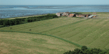
 |
|
View
from defensive tower. Ditches (drainage channels) from the 16th
century can still be seen.
(Foto: Dr. Julia Gebert) |
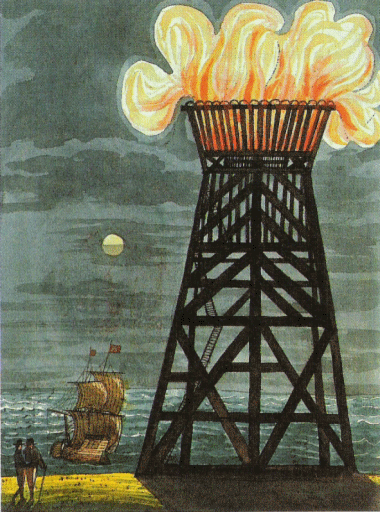
Navigational light on
Neuwerk, the 'Blüse'
built in 1644/1645 (NEß 2001, 12) |
In the middle of the 17th century a navigational light was lit for the first
time. A Blüsenfeuer (which used hard coal) was tended by four Blüseners who
moved to the island.
At the end of the 18th century the tenants of Neuwerk were finally allowed
to purchase their farms. The buildings of these farmsteads were built in a
strictly functional style with hardly any decorative elements. One reason
for this plain style might have been the frequent damage caused by storm
tides which could have made a more elaborate building style seem rather
pointless.
3.3 Modern Times
In 1814 the defence tower was converted to a lighthouse. The lamp fire,
which since 1971 has been remote-controlled by Cuxhaven, became visible for
miles due to a system of parabolic mirrors.
From a tourist point of view Neuwerk was still barely known at the end of
the 19th century but registered an upswing when holidays at the seaside
became fashionable. Thus the first hotel on the island opened in 1905, in
1920 a school hostel opened up and as early as 1924 the tower was listed as
a protected monument. Farming, which used to be the main source of income,
started to lose its importance.
Neuwerk did not always belong to Hamburg. In the course of the Groß-Hamburg
act Prussia traded the areas of Altona, Harburg and Wandsbek with Hamburg
amongst others for Cuxhaven and Neuwerk. During the break-up of the country
of Prussia after the Second World War the Prussian rights, and thus Neuwerk,
passed to Lower Saxony. In the beginning of the 1960s, however, Neuwerk
became the focus of Hamburgian interests again. A deepwater harbour in the
area of Scharhörn was supposed to improve the harbour economy of Hamburg.
Hamburg and Lower Saxony began negotiations and in 1969 Neuwerk was
transferred back to Hamburg according to a treaty with Lower Saxony. The
planning phase and the pilot surveys for a deepwater harbour offshore of
Scharhörn took up most of the 1960s and 70s but in 1981 the senate shelved
their plans for the time being. Instead, most of the area was placed under
protection and eight years later the national park of Hamburgisches
Wattenmeer was founded. Today the complete Wadden Sea area of Hamburg is
protected. The Nationalpark-Haus, an information and administrative centre
for environmental protection and nature conservation was opened in 2004 on
the tower dwelling mound.
|
 |
|
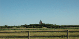
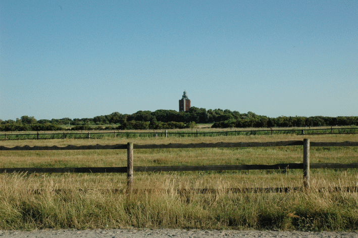
The defensive tower on Neuwerk
dominates the landscape view. (Foto: Dr. Julia Gebert) |
Next to the defence tower, which still dominates the landscape, there are
three farms, ten gastronomic businesses, one school, two school hostels, two
youth campgrounds, one bath, two landing stages and a pleasure craft
harbour. There is also one island shop, one fire station and a sewage plant.
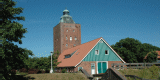
|
 |
|
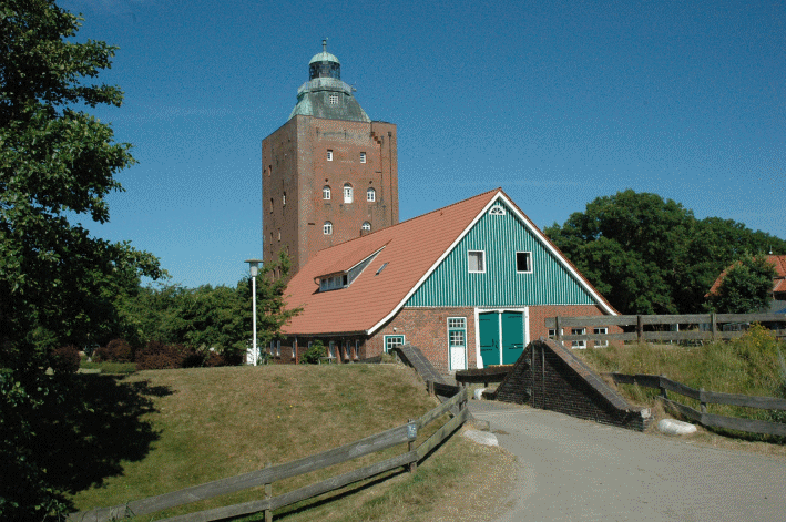
View on embanked tower mound.The 'Vogtscheune' with
schools field centre (foreground) and the defensive tower protected
under monument law since 1924. (Foto: Dr. Julia Gebert) |
The island dwellers whose numbers hardly ever reach more than 50 are mainly
making a living out of tourism. Agriculture has seriously declined and is
only continued non-intensively. The main source of income today is tourism.
On days with convenient low tide hours more than 2000 tourists come to the
island. All in all 100-120.000 daily visitors and overnight stays can be
counted in one season.
4. Modern development and planning
4.1 Land use
Neuwerk, as the only inhabited island in the 137.5 km² big national park
Hamburger Wattenmeer, has adapted its land use to the goals and plans of the
national park. For the protected areas special requirements have to be
observed.
Agriculture used to be the sole source of income but today it is run only
extensively. The last fields went out of use in 2005. The traditional focus
continues to lie with animal husbandry. Horses and cattle are grazed on
areas which have been included in the extensification contracts of the
program for nature conservation in the cultural landscape of Hamburg.
Another distinctive feature is the specialisation of one business in the
rehabilitation of sports and riding horses in the mudflats as well as the
care and healing of horses with lung diseases.
4.2 Settlement development
The law for nature conservation includes a general building ban. Exceptions
have to be approved both by the building laws as well as by the nature
conservation law of Hamburg. On Neuwerk special emphasis is placed on
preserving the dominance of the tower and the tower dwelling mound. Also no
so-far undeveloped areas are to be built on and new buildings are avoided in
favour of extensions of existing ones. There is also a limitation to the
heights of buildings and regulations to construct saddle roofs and to use of
weather-proof material such as red bricks.
By following these regulations attempts have been made to preserve the
village character of the settlement on Neuwerk. Nevertheless the historic
picture of the island has already been impaired by small tourist-based
family businesses, by areas used for logistics and maintenance and by the
radar tower built for the navigation on the Elbe.
Another goal within the national park program is the consolidation of
economic interests with the ecological requirements of nature conservation.
A program promoting alternative energies, e.g. solar panels, the
encouragement of non-intensive agriculture and the promotion of gentle
tourism with overnight stays as well as the problem of providing for the
tourists who are only coming for the day are parts of this project.
4.3 Industry and energy
There is no industry on Neuwerk, neither existing nor planned.
Although in the area of Neuwerk there is an emphasis on regenerative
energies, there are no wind energy plants allowed due to the national park
laws, the regulations of the building laws, the political agreements of the
Trilateral Wadden Sea Plan (1997) and especially because of the goal to
preserve the visual dominance of the tower. The only exception has been the
54 metre-high radar tower which was built just offshore in 1988. It has an
important function in the traffic safety of the mouth of the Elbe.
4.4 Infrastructure
The car-free island of Neuwerk can be reached by ferry from
Cuxhaven. The crossing takes about 1.5 hours and operates daily from April
to October. A second means of reaching the island is the tidal dependant
mudflat path. The pedestrian path from Sahlenburg takes about 2.5 hours to
walk. From Duhnen it is a walk of about 3 hours. The 9 kilometres long way
is also used by horse carts as well as by supply carts drawn by tractors.
On Neuwerk the road network only consists of footpaths and bike paths since
there are no cars on the island. Only the paths which are necessary for the
flood protection, like the circular way along the dyke and the middle path
leading to the tower dwelling mound, have interlocking concrete paving. The
landing stages do not have any infra structure.
5. Legal and spatial planning aspects
Neuwerk is divided into two protective zones. The dyked-in core island and a
large part of the land north of the dyke belong to Zone II. The rest of the
area comprises Zone I and is subject to special protection.
|
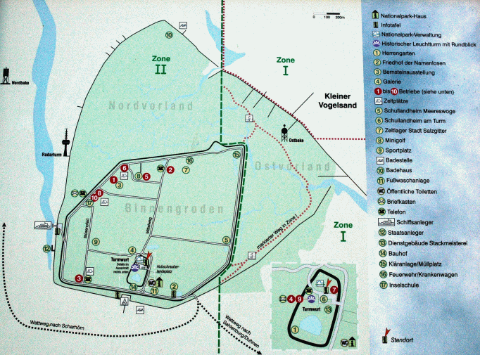 |
|
Information board on Neuwerk. The poorly developed
infrastructure and the separation in protection zone I and II can
clearly be seen. (Foto: Dr. Julia Gebert) |
In view of the land use planning Neuwerk is mainly subject to the laws of
the national park Hamburgisches Wattenmeer as well as to the nature
conservational laws of Hamburg and all other superior laws.
6. Vulnerabilities
6.1 Settlement
The historic settlement pattern on the island has been impacted upon by
small tourist-based family businesses, by areas used for logistics and
maintenance and by the radar tower built for the navigation on the Elbe.
6.2 Agriculture
Agriculture has seriously declined and is only continued non-intensively.
Although the non intensification of agriculture will help preserve heritage
cultural landscape features the increasing loss of the traditional
agricultural use will have an effect on traditional farming practices.
6.3 Tourism
The main source of income on Neuwerk is tourism. A decline of tourism would
cause significant stress on Neuwerk, however, the goals of the national park
would still have to rank higher. The increase in tourism, especially day
tourists increases the infrastructure needed to deal with these visitors,
especially in the case of drinking water. There is the potential of a new
water pipe from the mainland which could be detrimental to the
archaeological deposits.
6.4 Natural Erosion
There is also the danger of natural forces. The installations for flood
protection have to controlled, fixed and improved on a regular basis so that
in the long run the island will not erode and can withstand the heavy storm
tides.
7. Potentials
7.1 Settlement
Regulations have attempted to preserve the village character of the
settlement on Neuwerk with considerable success. Any future development
should be carefully planned to both respect and add to the cultural and
natural heritage of the island.
7.2 Tourism
The promotion of the national park has a great impact on the rising number
of tourists. Visitors coming to stay just for the day or overnight show a
great interest in the nature and landscape and their behaviour and attitude
towards environmental protection and nature conservation can be influenced
by providing targeted information and organising events. There is potential
for the management and promotion of the cultural heritage to be integrated
with the environmental and nature protection.
8. Sources
Dannmeyer, F. et al. (Hrsg.; 1952): Ein Turm und seine
Insel, Monographie der Nordseeinsel Neuwerk. Cuxhaven.
Höpke, W. (1952): Die Bevölkerung der Insel Neuwerk. In: F. Dannmeyer, Ein
Turm und seine Insel, Monographie der Nordseeinsel Neuwerk. Cuxhaven,
99–112.
Linke, G. (2001): Die Entstehung der Insel Neuwerk - unter Berücksichtigung
der Verhältnisse bei Scharhörn. In: Probleme der Küstenforschung im
südlichen Nordseegebiet 27. Oldenburg, 11–37.
Meier, D. (2006): Die Nordseeküste. Geschichte einer Landschaft. Heide.
Müller, H.-O. (1984): Die Leuchtfeuer von Cuxhaven und Neuwerk. Herford.
Neß, O. (2001): Zu Besuch auf Neuwerk. Hamburg.
Thieme, H. (1997): Älteres Paläolithikum aus dem Gebiet zwischen Weser und
Elbe. In: L. Fiedler (Hrsg.), Archäologie der ältesten Kultur in
Deutschland. Materialien zur Vor- und Frühgeschichte von Hessen 18, 328–356.
Uhl, J. (1952): Wasserbauten und Deiche. In: F. Dannmeyer, Ein Turm und
seine Insel, Monographie der Nordseeinsel Neuwerk. Cuxhaven, 75–86.
Umweltbehörde Hamburg (Hrsg.; 2001): Nationalpark-Atlas Hamburgisches
Wattenmeer, Nationalparkplan: Teil 1. Schriftenreihe der Umweltbehörde Heft
Nr. 50, Hamburg.
|