|
1. Overview
|
Name: |
Norderland |
|
Delimitation: |
North Sea mud flats, Ley
Bay, Dornumersiel, Berumerfehn Canal, Nenndorf Moor and Lake "Ewiges
Meer", neighbouring entities Harlingerland and Brookmerland. |
|
Size: |
Approx. 174 km2 |
|
Location
- map: |
East North Sea marsh and
geest borders, administrative district Aurich, Lower Saxony, Germany |
|
Origin of name: |
Not known |
|
Relationship/similarities with other cultural entities: |
Landscape and cultural
similarities to Harlingerland and Krummhorn. Shares a similar
political history in the Middle Ages under Chieftain rule with other
Lower Saxony and East Frisian areas. |
|
Characteristic elements and
ensembles: |
Rural house-forms, linear
villages, artificial mounds, Geest, agricultural use, drainage
channels, fishing industry, coastal protection. |

2. Geology and geography
2.1 General
The Norderland, together with the city of Norden, is sited in the extreme
north-west of the East Frisian peninsula at the end of the Oldenburg and
East Frisian Geest ridge. The Norderland borders on the Harlingerland in the
east and the Brookmerland in the south. Its present dimensions correspond to
the old administrative district of the Norderland, roughly enclosing the
area of Norden and the local government area Hage. Whist the city of Norden
is located on a Geest-island, the rest of the Norderland is characterised by
the marsh-landscapes of the Westermarsch, Ostermarsch and Hage Marsh. These
are primarily made up of recent sea-sediments (sand, silt and clay), while
the old marsh (at Hooker and Wischer) to the south lies in front of the
Geest ridge. In the more recent marsh area especially, variations in sea
level led to temporary re-salinification and areas being turned into fenland.
Thus the profile of the marsh consists of alternating layers of mineral
matter and peat layers. Natural drainage of the land occurs via the Norder
Tief area into the Ley Bay, as well as via the water courses directed to the
north-east. Off the coast there is the Watt, the mud flats, a part of the
Wadden Sea National Park of Lower Saxony.
2.2 Present landscape
Today the Norderland, due to the fertility of its alluvial marshy soils, is
characterised by intensive agricultural usage. The traditional settlement
forms and the numerous drainage channels characterise the marsh landscape.
The Norder Tief as well as
Lay Bay serves as main
drainage channels which flow into the Marschtief and Dornumersiel Tief. The
settlement of the marshland mainly consists of scattered farmsteads and
marshland settlements on dwelling mounds, as for example at
Westerloog and
Osterloog in the Lintel
Moor. The biggest settlement is the town of
Norden (approx. 25.000
inhabitants) with its harbour of Norddeich.
Geomorphologically the alluvial marshy land is delimited to the south-west
and the south by the Geest and the Nenndorf Moor (peatland).
3. Landscape and settlement history
The Norderland has a complex settlement history, and its marsh landscape
reflects man’s continual struggle to gain and preserve the marsh for human
habitation. Characteristic monuments of the process are the dykes, fens and
dwelling mounds. The large scale investigation of the North German mud flats,
as well as to a smaller degree the Brookmerland marsh, has been carried out
by the Archaeological Service of the East-Frisian Association (Ostfriesische
Landschaft) and the Institute for Historic Coastal Research (Institut für
historische Küstenforschung) among others.
3.1 Prehistoric and Medieval Times
Archaeologically, the exact date when the Norderland was settled can only be
determined indirectly. On the basis of comparison with surrounding areas, it
can be assumed that Norderland was affected by wider prehistoric
developments. At the beginning of the post-Ice Age, today’s southern North
Sea coast was dry land and the North Sea coast was in the area of the Dogger
Bank, and it can be presumed that Noderland’s tidal river-marshes were
frequented in the late Palaeolithic and the Mesolithic by hunter-gatherer
groups. It is possible that evidence for this and later phases are located
below the river marsh with its millennia of sediment deposits. Subsequently
the Geest has been settled by farmers since the Neolithic Age, from about
4,000 BC, the marsh colonisation in the sea marshes began in the early 1st
century AD.
As a result of sea level variations, the low lying coastal fringe turned
into land, thus enabling the settlement of the marsh. The areas sited
further to the west of the north-west German coastal region seem to have
been settled earlier than the marshes on the other side of the Weser and the
Elbe. Based on archaeological research in Süderhaus and Westdorf we have
evidence of settlements around the 1st century AD which required artificial
elevation of the settlements, with the creation of low mounds of clay and
dung. In the 5/6th century AD the settlement activity in the area appears to
have decreased. However, in the 7/8th century AD increased settlement is
discernible. At the beginning the outer marshes, elevated a little by mud,
were settled with villages and farms on dwelling mounds, because these, in
contrast to the lower areas of Hooker and Wischer, kept naturally drier. In
the inner, lower marsh, the Sietland, only a few single farmyards were built,
otherwise it mainly functioned as pastureland. The individual small farms on
dwelling mounds in the marshes without dykes were surrounded by irregular
block-meadows. There is proof of settlement in these farms as early as the
early Middle Ages in the form of earthen-ware containing limestone grit from
individual dwelling-mounds in the Wischer and on the edge of the Hilgenried
Bay in the Hage Marsh. In addition there is evidence for an early medieval
graveyard on the north side of the dwelling-mound of "Süderhaus". From the
late Middle Ages the marsh was surrounded by dykes and was protected
permanently against high tides. At the same time the natural drainage system
was completely changed by partially diverting watercourses to floodgates (as
at Sieltog and Marsch-Tief). Archaeological evidence has demonstrated that a
continuous coastal dyke has existed since the late Middle Ages, possibly
along today's road close to the coast from Osterloog via Honnewarf and
Wilhelmsfeld to Seelust and Theener. Even older dykes probably existed in
the Hage Marsh, for the damming of the former Hilgenried Bay and for the
protection of smaller settlement areas. The drainage of the areas inside the
dyke improved their agricultural potential which made inland colonisation
possible; this took place after the 13th century.
A number of settlements were established on the higher Geest-ridges during
the Middle Ages, which still shape settlement-centres today. As their names
demonstrate, Lintel, Ekel
and also Norden belong to
the early medieval settlement foundations. Norden, originally a village on a
long dwelling-mound, which received town rights in 1255, was at the end of
two long-distance trade routes (Emsweg to Münster, Küstenweg to Bremen) and
gained trans-regional significance as a trading place. Livestock,
Muschelkalk and salt were exported from there. The Benedictine monastery
Marienthal was founded in the 11th century and in 1264 the Dominicans
settled at the Fräuleinshof.
In 1285 a castle was built at Norden. The former economic importance of the
city is still reflected in a number of buildings, including the
Ludgeri Church dating from
the 13th century which has the second largest preserved Arp Schnitger organ
(1693), as well as the Castle
Lütetsburg. In addition the large marketplace, probably built in the
first half of the 13th century, reflects the economic significance of
Norden. Nesse is another
early medieval village, with narrow streets built alongside a road on a long
artificial mound. Built on a former sea dyke as a settlement alongside a
road, the small town of Hage
is only mentioned after 1400.
As in the rest of East Friesia, the previous co-operative territorial form
of community was also replaced in the Norderland by hierarchical forms:
chieftains ended the existence of autonomous land communities. In the 15th
century this system of local- and regional noblemen developed via provincial
nobles into the region to the imperial count in East Friesia.
3.2 Early Modern Times
Numerous severe storm-floods between 1150 and 1600, which swamped the
existing dykes, led to considerable variations in the coastline in the
Norderland. In the course of the storm floods Ley Bay developed as (?) a
visible result of the forces of nature. Dyke construction measures continued
due to climatic changes, including the “Little Ice Age” between 1300 and
1850, which was marked by an increase in strong storm-floods. Thus the
Christmas storm-flood of 1717 led to a complete flooding of the Norderland,
and during the February flood of 1825 the coastal dykes of the Norderland
broke in numerous places. In addition the climate of this period had a
negative effect on the agricultural yield. However, growing experience in
dyke-construction and the support of the nobility led to a constant
improvement in coastal protection-measures. From about 1500 a change
occurred, with the balance turning from loss to gain with the setting up of
dykes around bays and along the coastal lines of the North Sea. In the
Norderland, Harling Bay and Ley Bay are relevant in this respect. When Ley
Bay was at its widest at the end of the 15th century, it reached as far as
the city of Norden and provided direct access to the sea. The resulting
harbour, which survived far into the 19th century, allowed Norden to
flourish economically over a long period. The ships from Norden sailed the
waters of the North Sea and Baltic under their own merchant flag. However,
the erection of dykes in 1498 created the first polders in Ley Bay and the
reclamation of land began. Up to the end of the 16th century the five
polders in Ley Bay were surrounded by dykes.
In 1531 the army of the nobleman Balthasar von Esens invaded the unfortified
town of Norden, and in the process destroyed a number of monasteries and St.
Andrew’s Church.
From an economic point of view the Norderland was strongly orientated
towards agriculture, however fishing and overseas trade also played an
important role. Due to the dykes the agricultural and settlement areas were
constantly expanding.
East Frisia was elevated to an imperial county in 1464 and had extended to
its present area by 1600. In 1744 East Frisia, and thus also the Norderland,
were incorporated into the kingdom of Prussia. After the period of
Napoleonic occupation from 1806 to 1813 it fell to the kingdom of Hanover.
With the end of the Hanoverian kingdom Norderland returned to Prussia.
3.3 Modern Times
In the 19th century marsh-settlements prevailed in the marsh region of the
Norderland, directly behind the main line of dykes, whilst the region east
of Norden continued to be marked by settlements on dwelling mounds. Because
of the influx of refugees after World War Two the populationin the
Norderland increased considerably, the new town of Norden-Neustadt was built
at this time. The renovation of the historic part of the town, which was
carried out in the 1960s and 1970s, led to a big loss of the historical
fabric in Norden and to the disruption of the townscape because of the
building of multi-apartment houses and three multi-storey blocks of flats.
Since 1950 a new rise in storm-flood activity has been registered again and
the tide-heights of 1962, 1976 and 1994 are amongst the highest water levels
ever measured on the coast of Lower Saxony. The storm floods of 1953 and
1962, in particular led to considerable expansion and the strengthening of
coastal protection-measures. The first plan to build dykes around the entire
Ley Bay were not carried out in the 1980s, due to changed social attitudes
towards coastal protection. However, a few years ago, the last big dyke in
Lower Saxony was built in Ley Bay. Here the newly reclaimed areas were
designed as areas for nature conservation and water. 65 hectares were
dredged, up to two metres deep, within the dyke to extract clay. This area
and a further 15 ha of low lying land was then flooded and turned into a
nature reserve.
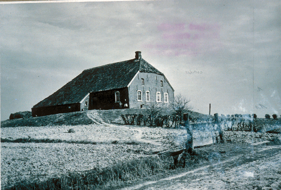 |
| Historic farmstead on a dwelling
mound nearby Norden |
The Norderland was opened up to railway traffic by the connection of Norden
in 1883 to the railway, which had opened in the same year between Emden and
Aurich. Also in 1883 this line was extended via Hage and Dornum to Esens. In
1892 the construction of the railway-line from Norden to Norddeich followed.
At the beginning of the 19th century numerous unsurfaced roads, which
connected the single settlements and scattered farmsteads with each other,
led through the Norderland. In the second half the 19th century a
north-south connection linked Norden to the road between Emden and Aurich,
which had already existed around 1863 and which the B72 still follows today.
A further connection to the south was a regional road between Aurich and
Dornum. From west to east a regional-road ran between Norden and Dornum, as
well as a further one branching off linking the villages directly behind the
dyke.
4. Modern development and planning
In its regional planning report for 2005 the Federal Office for Building and
Regional Planning lists the Norderland as a region which is marked by strong
economic growth worthwhile this development may not lead to an increased use
of space for settlements.
4.1 Land use
The marshy areas are still used traditionally for agriculture, with the
marshes directly behind the dykes being reserved for arable farming. In the
areas further inland, on Ostermarsch and Hage Marsh, meadows characterise
the landscape. Beside the areas, primarily used for agriculture, small
woodlands exist close to Hage and Lütetsburg. The structural change in
agriculture is evident, too, in the Norderland there is an increase in the
number of abandoned farms as well as an increase in the size of the
remaining farms. Since the end of the 1960s this has led to a decrease in
arable farming in the marsh area, whilst the proportion of permanent meadow
land has also decreased. Despite the large-scale agricultural use of the
region, only a small percentage of less than 30 % of employed people work in
agriculture, and this is declining. The economic importance of
fishing is slight. However it belongs to the image of a coastal society and
its way of life and is very important for tourism.
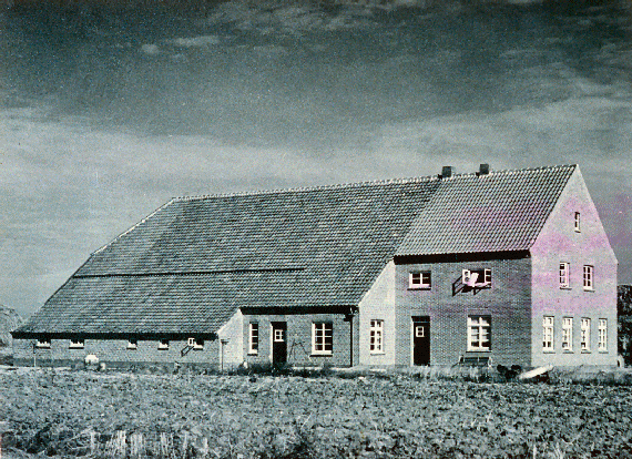 |
| Historic farmstead on a dwelling
mound nearby Norden |
The mud flats of the North Sea are characterised by their high biological
productivity for instance as a spawning ground for many types of fish. Off
the coast of the Norderland there are vital breeding and resting areas for
many kinds of birds. The Itzendorf Bank, north-west of Norddeich is used at
low tide as a resting place by seals and birds. The salt meadows, mud
flat-areas and banks are a part of the Wadden Sea National Park of Lower
Saxony under special protection since 1986. Outside the dykes of the
Norderland, parts of the Norden mud flats, the Ostmarsch mud flats,
Westernessmerheller, Osternessmerheller and Ley Bay belong to the protective
zone I, which as a resting area may be entered only on the marked paths. The
region of the Norden mud flats off Norddeich, the Ostermarsch mud flats with
the High Reef, as well as Hilgenried mud flats, Nessmer mud flats and Dornum
mud flats belong to Protective Zone II, which may be entered. The salt
meadows, however, may only be entered on the marked paths during hatching-
and rearing time of birds between 1st of April and 31st of July.
4.2 Settlement development
The Norderland belongs to the catchment area of the town of Emden, which is
the principal destination for business commuters in this region. Tourism is
an important component in the economy of the Norderland and is characterised
by an increasing number of overnight stays. The number of visitors depends
greatly on the season, as mainly comprises summer-tourism and day-visitors.
In addition a great number of employed people partially live off tourism,
with small businesses playing an important role in overnight tourism in the
Norderland. Supplementary income, as well as part-time employment and
seasonal employment play an important role. In the regional planning
programme of the administrative district of Aurich of 1992 the places
Dornumersiel, Nessmersiel and Norddeich are named as places dedicated to the
functions of relaxation and tourism. At the same time these are the
locations for harbours (general harbours and sports boat harbours) and the
communities have been allocated the special development task of
“relaxation”/ “leisure time activities”.
Apart from the tea-museum, Norden has a museum of local history in the old
town hall. Places of interest, apart from the large marketplace, are the
Ludgeri Church as well as the Frisia-Mill. Norddeich, apart from a beach,
offers numerous tourist attractions, such as indoor swimming- and wave pool
and the national park-centre with the seal rearing station.
Attractions in the region of the local administrative area
Hage, include the
St. Ansgari Church in Hage
with its crooked tower, the Hage Mill from 1597 (being the highest mill in
East Friesia), the castle grounds of
Lütetsburg and the
Magda-Heyken-House with a
local history collection can be named. The Motodrom in
Halbemond, a speedway-arena,
functions as a further tourist attraction. In Hilgenriedersiel, a part of
Hage Marsh, a number of natural bathing places on the East Frisian North Sea
coast exist. Hage is also a health resort.
Further attractions in the Norderland are the moated castle of
Berum, the church in
Arle from the 12th century,
the castle surrounded by water of
Norderburg in Dornum and
St. Bartholomew’s Church
from the 12th century in Dornum.
Apart from the bathing-areas close to
Neßmersiel and
Dornumersiel there is a
national park-house with information on the Wadden Sea National Park of
Lower Saxony.
4.3 Industry and energy
Tourism is the main economic focal point for the city of Norden (North Sea
bathing-resort Norden-Norderdeich), in addition to the service trade,
mechanical engineering, metal processing and printing technology. In
addition, tea-processing companies are settled in the town (tea-town
Norden). In the remaining area of the Norderland the first wind turbines
have been installed.
4.4 Infrastructure
The Norderland was opened up to traffic via the North Sea, as well as via
the country roads and up to this day the peripheral location of the
Norderland is apparent. The nearest motorway connection to the A31 is only
as far as Emden. From the mid 19th century the road-connection leading to
Norden was extended from the connecting stretch Emden – Aurich (today’s B210
and B72). The present B72, which leads up to Norddeich, follows the old road.
At the moment the federal road still runs through the city of Norden,
however a by-pass around the east of the city is being built. The other
north-south and east-west connections are only completed by district roads.
In order to link the rural settlements and single farms a strongly branched
traffic-network is necessary.
The railway-connection to Norden, Norddeich and Norddeich-Mole is maintained
today by the network of the Deutsche Bahn AG, while since its closure in
1983 (passenger traffic) and 1989 (freight traffic), the stretch between
Norden and Dornum is only used by the
museum-train Küstenbahn
Ostfriesland. The remainder of the Norderland can be reached by means of
public transport buses.
There are ferry-connections to the East Frisian islands from Norddeich to
Norderney and Juist and from Westerdeich to Baltrum. A further traffic-link
to the islands is via the airport close to Norddeich.
5. Legal and spatial planning aspects
As far as regional planning is concerned the Norderland communities are
subject to the Regional Planning Programme of 1992 of the administrative
district of Aurich, as well as the regional planning programme set up by
Lower Saxony. In its regional planning programme of 1994 with its
supplements of 1998 and 2002 the town of Norden is designated as the
region’s centre. The communities of The Norderland belong to the East
Frisian area. This is the only superior municipal assosiation in Lower
Saxony.
6. Vulnerabilities
6.1 Settlement
The historic settlement pattern has survived in the marsh-areas to a large
extent with only limited expansion. The increased immigration to the rural
areas creates a growing and changed demand on land use, which could become a
problem in the Norderland. Up to now only in urban Norden have extensive
areas been designated as building land. However, the marsh region could also
be affected if the demand increases. The settlement pattern on the coast has
been significantly changed with the development of holiday homes in
non-local styles.
6.2 Agriculture
The structural change in agriculture and the dependence of the future
direction taken by this branch of industry on the agrarian policy of the EU,
will continue to accelerate the trend towards intensification of production
in the Norderland. At the same time the proportion of agricultural land put
under protection or with restrictions on use is increasing. This has
resulted in land being abandoned due to the low profit margins. Declining
numbers of employed people in agriculture has led to an increase in
commuters, as the job market in the rural regions cannot retain the work
force.
6.3 Industry and energy
The building of wind farms may lead to changes in landscape perception and
thus in the image of the historically evolved landscape. It is important to
integrate cultural heritage within the development plans put forward for the
renewable energy plants.
6.4 Natural processes
A main problem of the future, which is difficult to predict, is climate
change which is progressing faster than expected. Already since 1950
increasing storm flood activity has been observed. Reinforced coastal
protection-measures with dyke heightening and dyke widening will be
necessary, requiring the quarrying of clay and sand needed for it. Any plans
to protect the area will need to have the cultural heritage interests as an
integrated part of the proposals. Nature conservation interests oppose the
dyke extensions outwards, while the moving of dykes inwards meets with
opposition from within the local population. This situation in densely
built-up town areas and tourism sites, as for example in Norderdeich is
especially problematic. The scenarios of the change in climate forecast up
to now will affect all sectors of the Norderland: cultivation and settlement,
agriculture, tourism, shipping, port business, fishing, water distribution
and coastal ecosystems.
7. Potentials
7.1 Settlement
In the Norderland most forms of settlement and use of the land, adjusted to
the lives of the people in the marshes of the North Sea coast, are preserved
to a considerable degree. The constant interaction with the special
conditions of this area of settlement can be seen as the cultural and
historic heritage in the landscape: farm-dwelling mounds, village-dwelling
mounds, old and new dyke-lines (e.g. in the former Ley Bay), areas of
brackish water, colcs, clay pits, and drainage ditches reflect the
interactions in the past and the present with the sea.
7.2 Agriculture
An important precondition for maintaining the traditional structure of the
landscape and the buildings within it is the use of the land by private
individuals, tourism and agriculture. A chance of linking the two economic
branches, tourism and agriculture, could be the expansion of ecological
agriculture, as well as the inclusion and encouragement of farmers in
processes aimed at preserving the countryside.
7.3 Tourism
In view of the peripheral location of The Norderland on the mainland the
possibilities of intensifying co-operation in tourism with the offshore
islands should be considered. The cultural heritage of the area can be used
to encourage and promote tourism in the Norderland. At the same time care
has to be taken that the original character of the cultural landscape is not
lost, but is integrated into the development of the Norderland for the
purposes of future requirements.
7.4 Nature conservation
The aims of nature conservation and coastal protection can be perfectly well
integrated, as the pilot project of Deichacht Norden in 2003 showed. As both
parties would like to achieve the preservation of a stable dyke foreshore
and land outside the dykes need not necessarily be used for agricultural
production, the farmers in Norden appear to have taken on the role of
guardians of the countryside. A coastal area several kilometres wide along
the coastline of The Norderland should be considered as an area reserved for
leisure activities. It is essential that any development or management plans
for these areas integrate the cultural heritage. This then provides the
potential to both promote and manage the cultural heritage of the area.
8. Sources
Author: Wolfgang Scherf
Behre, K.-E. 1999: Die Veränderungen der niedersächsischen Küstenlinien in
den letzten 3000 Jahren und ihre Ursachen. Probleme der Küstenforschung 26,
1999, 9-33.
Behre, K.E. 1999: Naturraum und Kulturlandschaftsentwicklung Ostfrieslands.
Führer zu archäologischen Denkmälern in Deutschland 35. Ostfriesland.
Stuttgart 1999, 10-27.
Behre, K.-E., Haarnagel, W. 1984: Veränderungen des Küstenverlaufs. Ursachen
und Auswirkungen, III Niedersachsen. In: G. Kossack, K.-E. Behre und P.
Schmid (Hrsg.), Archäologische und naturwissenschaftliche Untersuchungen an
Siedlungen im deutschen Küstengebiet 1, Ländliche Siedlungen, Weinheim 1984,
68-82.
Brandt, K.1992: Besiedlungsgeschichte der Nord- und Ostseeküste bis zum
Beginn des Deichbaus. In: KRAMER, J. und ROHDE, H., Historischer
Küstenschutz, Deichbau, Inselschutz und Binnenentwässerung an Nord- und
Ostsee, Stuttgart 1992, 207-240.
Canzler, G. 1994: Norden. Museen im Alten Rathaus. 75 Jahre Heimatverein
Norderland. Norden 1994.
Heun, S. 1995: Archäologische Untersuchungen auf dem Hüttenplatz in
Lütetsburg, Ldkr. Aurich. Archäologische Mitteilungen aus
Nordwestdeutschland 18, 1995, 85-110.
Jeschke, A. 2004: Raumplanung als vorsorgendes Instrument im
Küstenmanagement. Oldenburg 2004.
Kramer, J. 1992: Küstenschutz und Binnenentwässerung zwischen Ems und Weser.
In: Kramer, J. und Rohde, H., Historischer Küstenschutz, Deichbau,
Inselschutz und Binnenentwässerung an Nord- und Ostsee, Stuttgart 1992,
207-240.
Landkreis Aurich 1992: Regionales Raumordnungsprogramm des Landkreises
Aurich. Aurich 1992.
van Lengen, H. 1999: Burgenbau und Stadtentwicklung. Führer zu
archäologischen Denkmälern in Deutschland 35. Ostfriesland. Stuttgart 1999,
128-140.
Reinhardt, W. 1965: Wurtengrabungen in Ostfriesland, Fundchronik Land
Niedersachsen und Land Bremen. Germania 43, 1965, 410-413.
Reinhardt, W. 1969: Die Orts- und Flurnamen Ostfrieslands in ihrer
siedlungsgeschichtlichen Entwicklung. In: J. Ohling (Hrsg.), Ostfriesland im
Schutze des Deiches 1. Pewsum 1969, 201-375.
Schwarz, W. 2000: Die Wurtenlandschaft im Norderland. Archäologische
Denkmäler zwischen Weser und Ems. Archäologische Mitteilungen aus
Nordwestdeutschland, Beiheft 34, Oldenburg 2000, 215-218.
Wassermann, E. 1985: Aufstrecksiedlungen in Ostfriesland. Abhandlungen und
Vorträge zur Geschichte Ostfrieslands 61. Aurich 1985.
Full catalogue of historic maps used, survey evidence etc.
Karte des Nordwestlichen Teils von Ostfriesland. Herausgegeben vom
Generalmajor Le Coq 1805, Sect. I. Nachdruck 1984.
|