|
1. Overview
|
Name: |
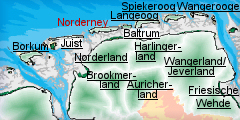
Norderney |
|
Delimitation: |
The island is separated from Juist to the
west by the Busentief inlet and from Baltrum to the east by the
Wichter Ee, the southern shore is delimited by the Rifgat inlet.
Neighbouring entities are the islands of Juist and Baltrum, and the
Norderland on the mainland, the surrounding mudflats belong to the
National Park “Niedersächsisches Wattenmeer”. |
|
Size: |
The island is 14 km long, and about 2.5km
wide. The overall area of the island is c. 26.3 km². |
|
Location
- map: |
Nordeney is a sandy island offshore of the
mudflat coast of Lower Saxony and belongs to the district of Aurich,
federal state of Lower Saxony, Germany. |
|
Origin of name: |
The name Nordeney derives from ‘Norder neys
Oog’ meaning Northern New Island. |
|
Relationship/similarities with other cultural entities: |
Frisian Islands, islands of Lower Saxony,
of the Netherlands, dune landscapes, mudflats, national park of Lower
Saxony, maritime landscapes and settlements. |
|
Characteristic elements and
ensembles: |
Wattenmeer National Park, Nordeney ‘Kap’ or
cape building. |

2. Geology and geography
2.1 General
The process by which the islands came into existence began about 10.000
years ago. Unlike the North Frisian Islands on the coast of Schleswig
Holstein and Denmark, the East Frisian Islands are not remnants of former
mainland. Instead they were created by deposition of sediments by the tide
and currents. These keep the water in constant movement, with the direction
of the current changes with the tides. These bodies of water carry
significant amounts of sand. In shallow water, when the carrying capacity of
the current lessens, the sand is deposited and the waves shape it into
barrier beaches and Platen (sandbanks) which are subsequently reinforced by
plant growth. The result is a sandy barrier island which, if unprotected,
gradually shifts position over the millennia, losing material on the seaward
side and depositing it on the leeward side. The island, in its present form,
has only existed since the middle of the 16th century, making it the
youngest of the seven East Frisian Islands.
2.2 Present landscape
The western end of the island comprises the town of Nordeney, to the east of
this is a band of dunes and the only surviving areas of agricultural land.
The entire eastern half of the island belongs to the National Park
Niedersächsisches Wattenmeer and comprises dunes and saltmarsh. The northern,
seaward, side of the island consists of a single large, dry sandy beach,
which widens towards the east. The island elevation is 5m above sea-level.
3. Landscape and settlement history
The large scale investigation of the North German mud flats by the
Archaeological Service of the East-Frisian Association (Ostfriesische
Landschaft) and the Institute for Historic Coastal Research among others,
has added considerably to our understanding of this area.
3.1 Prehistoric and Medieval Times
Geologically speaking, the island is quite young. Even though there are some
prehistoric finds from the region of East Frisia there are no traces of
prehistoric activity on the present island. However, since the island has
repeatedly changed its shape and location over time any archaeological finds
would be buried beneath metres of sediment or in the sea.
The island had its origins in the larger island of Buise, this was split in
half by the “Grote Mandrenke” flood of 1362. The surviving eastern portion
of the island was renamed Osterende. What was left of Buise shrunk in size
over the years, finally disappearing into the sea during the Petri flood of
1651. In contrast, Osterende grew in size. A 1550 census refers to it as
‘Norder neys Oog’ (Northern New Island), and notes that it had a church and
18 houses. The inhabitants at this time worked principally as fishermen, the
island’s climate and soils are not suitable for intensive agriculture.
Although there are no written sources for the earlier medieval period in
Nordeney, it is believed that the first permanent settlements on the island
were established during the 13th and 14th centuries, the first documented
record is for 1398. A town may have developed on the western part, protected
by the surrounding high dunes. These would have been very vunerable to
flooding events and would have severely damaged, if not lost altogether,
during the 1362 flood.
3.2 Early Modern Times
In 1650 the island was about 8.3km long (approx. 5.7km shorter than its
present length), with a village of 18 houses, a church and about 101
inhabitants. The island suffered considerably in the Christmas Flood of
1717. In the 17th and early 18th century fishing remained the primary
economy of Nordeney. By the second half of the 18th century the marine trade
industry had grown in importance.
In 1797 Nordeney became the first German resort in the North Sea. The resort
featured meeting houses and bath houses, as well as bathing machines.
Initially the guests were boarded by the islanders, however in 1797 the
first of a series of wooden and thatched resort houses was built.
The Nordeney ‘Kap’ or cape building was first constructed in wood in 1848;
the present stone structure was erected in 1870. At night a fire was lit on
the top of the structure, a role that has been replaced by lighthouse. The
windmill dates to 1862.
Nordeney was part of Prussia from 1744 to 1806. Following Napoleon’s defeat
of Prussia in 1806 Nordeney, together with the rest of East Frisia, became
part of the Kingdom of Holland. The resort operations came to a standstill
during this period and were not reopened until 1811. Tourism played an
important role in the islands economy, combined with shellfish harvesting,
fishing and marine trade. In 1836 the Crown prince George of Hanover, Duke
of Cumberland, visited Nordeney for the first time, and from 1851 he held
court each summer on the island. With his patronage the island became a
resort of the rich and famous. In 1858 a 950m long deck with promenade was
built along the north-western tip of the island. In 1866 Prussia annexed the
Kingdom of Hanover and the island became again a Royal Prussian sea-bathing
establishment.
3.3 Modern Times
By 1899 the island had 4,018 inhabitants and 26,000 resort guests.
Developments of that date, catering for the local population and the guests,
included a hospital, a school, water system, electricity for the promenade,
stables, gas works, and a pier. The resort ceased to operate during World
War I, but had fully recovered by 1925, when regular flights to the island
by Lufthansa commenced.
The present resort comprises most of the western end of the island.
Architecturally it is a mix of turn of the century ‘resort architecture’,
including hotels, the promenade and the Marienhöhe, and modern resort
buildings, some of which are over 7 storeys high. The brick-built lighthouse
in the centre of the island is the most prominent feature and a local land
and seamark.
Within the English-speaking world Nordeney achieved fame as the setting for
the climax of the spy-novel The Riddle of the Sands by Erskine Childers.
4. Modern development and planning
The eastern half of Nordeney is part of the national park “Niedersächsisches
Wattenmeer” and is located within the quiet zone (Zone 1), the core area of
the nature protection area. Therefore the marginal dunes may not be accessed
at all and the saltmarsh can only be accessed in the company of professional
guides. Settlements, harbours and other infrastructure features on the
island, however, are not part of the protected area. The national park is
intended to preserve and protect the special character of the nature and
landscape of the dune and saltmarsh region, including the typical appearance
of the landscape. By this means the course of the natural processes is
supposed to be ensured and the biological diversity is to be preserved.
In its regional planning report of 2005, the Federal Office for Building and
Regional Planning includes the administrative district of Aurich amongst
those regions which show a small increase in population, and where
employment is decreasing. Actually, the development of Norderney is affected
by economic growth based on the tourist sector.
4.1 Land use
The economy of the island was traditionally orientated towards the sea:
fishing, production of shell lime and, at times, shipping. However, the
economic structures of the island have been largely dominated by tourism.
Since the early 19th century and to-day it is exclusively a tourist economy.
4.2 Settlement development
The settlement on the island is architecturally a resort settlement,
comprising a mixture of older resort buildings and more modern structures.
Unusually for the East Frisian islands it has a number of large,
multi-storey buildings (some in excess of 7 storeys), and the impression is
that of intensively-settled urban space. There is very little in the way of
buildings on the remainder of the island.
4.3 Industry and energy
No industry
4.4 Infrastructure
Traditionally the transport connection to Nordeney is by ferry from
Norddeich pier, near the German city of Norden. The island has also been
accessed by air since 1925. The status of the island as part of the National
park has affected all kinds of traffic on the island, and car traffic is
subject to strict regulations.
Water and electricity supplies were introduced to the island at the turn of
the 20th century.
5. Legal and spatial planning aspects
The Nordeney belongs to the district of Aurich in the federal state of Lower
Saxony. In terms of land use planning the community of Nordeney is subject
to the regional planning of the federal state of Lower Saxony respectively
of the landscape framework plan and the land utilisation plan of the
community. Additionally, there is the regional planning concept for the
coastal sea of Lower Saxony. The territory of the community ends at the MTTH
line (line of the Average High Tide). The coastal sea below the MTHW line is
„community-free area“. Accordingly, the regional and building plan only
applies to the land but not to the sea area.
The present regional plans for the federal state of Lower Saxony (LROP)
contain only a few regional planning goals for the sea area. The area of the
national park is registered at the EU for the Fauna Flora Habitat guideline
(FFH) and therefore belongs to the biotope network system Natura 2000. The
main part of the park lies within the territory of the EU water withdrawal
guideline. In 1996 the Wadden Sea area within the borders of the national
park was recognised by the UNESCO as biosphere reservation in the context of
the program „Man and Biosphere“.
With regard to building regulations there are the Niedersächsische
Bauordnung
(NbauO) and the Baugesetzbuch (BauGB; the German Statutory Code on
Construction and Building), also a Gestaltungssatzung (design statute) with
its Gestaltungsfibel (design primer) of 1995; a preservation statute;
tourism statute; a statute for the permission to subdivide land; various
complementary statutes to ca. 15 land-use plans (inner, middle and outer
area). In the course of the village reformation these regulations are just
being reviewed.
6. Vulnerabilities
6.1 Settlement
The early historic settlement pattern on Norderney has largely been
destroyed by the initial development of the island as a Hanoverian royal
baths, which itself has then suffered at the hands of later settlement
expansion. Building activity in the later 20th century has significantly
altered and destroyed the uniformly consistent picture of the resorts 19th
century architecture.
6.2 Tourism
Tourism is the major economic factor on Norderney and in itself provides
both potentials and threats to the Island. The visible expansion of the
Nordeney settlement clearly is a threat to any surviving archaeological
deposits or surviving cultural heritage features.
6.3 Industry and energy
The major reliance on tourism for the economy of the island could result
in the cultural heritage not being given appropriate protection in
competition with the development of the islands tourist infrastructure. The
extension of the 65km-long power cable channel leading over Norderney to the
mainland is going to cause massive interference into the submarine cultural
landscape of the North Sea.
6.4 Natural processes
Because of its exposed maritime location and the characteristics of a
sandy island Nordeney is also threatened by natural forces. The sands in
front of the islands and at the beach are continuously moved eastwards by
the surf which rolls in mainly from the north-east. This dynamic island
process is affecting the landscape and, in the long run, the settlement
structure. The geomorphological problems are not only caused by
nature-geography but human influence has also to be taken into account.
7. Potentials
7.1 Settlement
Only in the last two decades have efforts been made to protect the built
heritage of Nordeney with over 100 now protected. These buildings provide
the opportunity to promote the seaside and spa architecture of the
settlement to its many visitors.
7.2 Tourism
Nordeney already has a thriving tourism industry and there is potential
to further promote the Cultural Heritage through the existing network of
cycle routes, walking routes etc.
7.3 Nature conservation
There is potential for the cultural heritage to be incorporated within
management plans for the nature conservation on the island. By creating
integrated management plans for both the natural and cultural environment
both elements can benefit.
8. Sources
Backhaus, H. (1943): Die ostfriesischen Inseln und ihre
Entwicklung: ein Beitrag zu den Problemen der Küstenbildung im südlichen
Nordseegebiet. Oldenburg
Buchwald, K., Rincke, G., Rudolph, K-U. (1985): Gutachtliche Stellungsnahme
zu den Umweltproblemen der Ostfriesischen Inseln: Schlussbericht. Hannover
Bundesamt für Bauwesen und Raumordnung (BBR; 2005): Raumordnungsbericht
2005. Berichte 21, Bonn.
Merian (Heft 3/XXV), Ostfriesland und seine Inseln, Hoffmann und Campe
Verlag, Hamburg
Niedersächsisches Ministerium für den ländlichen Raum, Ernährung,
Landwirtschaft und Verbraucherschutz (2006) : Landes-Raumordungsprogramm
Niedersachsen, Ergänzung 2006, Hannover
Niedersächsisches Ministerium für Wirtschaft, Arbeit und Verkehr (2005):
Bericht der Landesregierung: Entwicklungen an der niedersächsischen Küste,
Hannover
Niemeier, G. (1972): Ostfriesische Inseln. Berlin
Petersen, J., Pott, R. (2005): Nordfriesische Inseln: Landschaft und
Vegetation im Wandel. Hannover
Pflüger, B. (1997): Gletscher- und Inlandeis in Polargebieten. Universität
Hamburg
Pott, R. (1995): Farbatlas Nordseeküste und Nordseeinsel: ausgewählte
Beispiele aus der südlichen Nordsee in geobotanischer Sicht. Stuttgart
Raumordungskonzept für das niedersächsische Küstenmeer. Herausgegeben vom
Niedersächsisches Ministerium für den ländlichen Raum, Ernährung,
Landwirtschaft und Verbraucherschutz - Regierungsvertretung Oldenburg -
Landesentwicklung, Raumordnung. Stand 2005.
Sindowski, K-H. (1973): Das ostfriesische Küstengebiet: Inseln, Watten und
Marschen. Berlin
Streif, H. (1990): Das ostfriesische Küstengebiet – Nordsee, Inseln, Watten
und Marschen. Sammlung Geologischer Führer 57. Berlin und Stuttgart.
Thieme, H. (1997): Älteres Paläolithikum aus dem Gebiet zwischen Weser und
Elbe. In: L. Fiedler [Hrsg.], Archäologie der ältesten Kultur in
Deutschland. Materialien zur Vor- und Frühgeschichte von Hessen 18, 328–356.
|