|
1. Overview
|
Name: |
Overledingen |
|
Delimitation: |
River Ems, rivers Leda
and Jümme |
|
Size: |
around
265 km² |
|
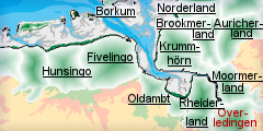
Location
- map: |
Southern East Frisia in
Lower Saxony, Lower Saxony, Germany |
|
Origin of name: |
‘Land above the Leda’, that is the land to
the south of the River Leda |
|
Relationship/similarities with other cultural entities: |
Similar natural and
cultural landscape to the neighbouring cultural entities around the
river Ems (Rheiderland, Krummhorn). |
|
Characteristic elements and
ensembles: |
Right-angle roads and
drainage systems, linear villages and embankment-hedges, Plantation
landscape, Fehn-villages, “Kübbing”-houses |

2. Geology and geography
2.1 General
The Ems in the east and
the rivers Leda and
Jümme in the north mark
the boundaries of Overledingen. Sited in Lower Saxony, Overledingen is one
of four historic cultural landscapes of the administrative district of Leer,
together with the Rheiderland, the Moormerland and the Lengenerland. The
name Overledingen can be translated as “Land above the Leda”, thus the area
south of the river Leda. Nowadays the historic cultural landscape includes
the communities of
Westoverledingen,
Westrhauderfehn and
Ostrhauderfehn, as well as the
Nettelburg area of the
town of Leer. In a north-south direction Overledingen stretches over 20 km
from Leer to Burlage.
Historically speaking the
Nesse-peninsula in the city of Leer also belongs to the region of
Overledingen, as the bend of the river Leda was only cut through recently.
The river marsh with the somewhat higher embankment bordered the
watercourses in the north of the Overledingerland. The low-lying land joined
this in the east. Overledingen is delimited by a Geest-ridge with in some
areas extensive bog which stretch to the edge of the marshland. In the south
lies the “Langholter Tief” area, the ”Rote Riede”, which drained the geest.
Nowadays practically all the bogs have been practically drained and stripped
extensively.
2.2 Present landscape
Overledingen is a plantation-landscape with hardy any relief, which has
fertile areas in the form of river marshes.
From north to south a Geest-ridge runs through the middle of the communal
district of Westoverledingen. Geest designates a type of land which results
from Ice Age deposits and which is generally higher than the marshes. In the
settlement history of northern Germany the Geest was populated earlier than
the marshes, as it offered protection against storm floods. Apart from this,
there was a strict division between farmers in Geest- and marsh cultures,
which was not least determined by the different degrees of fertility of the
area.
In the south of the Overledingerland there are a number of valley pastures,
which drain the Geest and its peatlands. Nowadays the peatlands are mainly
dry and drained and only survive rudimentarily. The historic settlement
structures that has hardly changed up to the present, are based on the
community of Westoverledingen along the Federal road (B 70), an old
army-road, which links East Frisia with the Emsland and the Münsterland.
3. Landscape and settlement history
The large scale investigation of the North German mud flats, as well as to a
smaller degree the Overledingen marsh, has been carried out by the
Archaeological Service of the East-Frisian Association (Ostfriesische
Landschaft) and the Institut für historische Küstenforschung (Institute for
Historic Coastal Research) among others.
3.1 Prehistoric and Medieval Times
The origins of settlement in the Overdingerland have been little studied.
From the Neolithic period, about 4.000 BC, the Geest was populated by
farmers. The few archaeological finds suggest that the settlement was
similar to that in the Moormerland. Here too in the marsh the settlements
were built on the high embankments of the rivers, so guaranteeing a certain
protection against flooding. A number of these settlements had to be
abandoned in the late Middle Ages as increased flooding made them
uninhabitable.
The Overledingenland belonged to the Carolingian Emsgau in the Middle Ages.
In the 13th century, after being freed from rule by foreign counts, an
independent Frisian regional community was established with the help of a
number of Saxon communities. The venue for general meetings of the
Sechzehner Rat (The Council of the Sixteen) in the Overdingerland was
presumably Backemoor,
situated in the north of the region. Due to the economic preconditions the
Overdingerland was unable to acquire a strong position comparable to that
of, for example, the Brookmerland further north, or the Harlinger- or
Jeverland. A system of classic feudalism did not establish itself in
Friesland.
In the 15th century Hamburg and the chieftains put an end to the area’s
autonomy. and Overledingerland came under the administrative rule of the
ruling family Tom Brok and then to the family Focko Ukena and then the
family Cirksena. Afterwards the Overledingerland merged with the county of
East Frisia.
3.2 Early Modern Times
Since the 17th century the region of the Overledingerland has been marked by
the strong imposition of man-made structures within the largely natural area.
In connection with the strong anthropogenic demands, the currently
prevailing cultural historic form of landscapes and settlements, especially
in the area of peatlands, was developed. There is an impression of a natural
area, largely untouched, in the Jümminger Hammrich between the rivers Leda
and Jümme. Nowadays the typical image of the cultural landscape is of
right-angle roads and drainage systems, linear villages and
embankment-hedges, demonstrating how people tried to colonise and cultivate
that fairly inhospitable land.
The unified community Rhauderfehn in Overledingen consists of ten centres,
all of which had quite different and far reaching historys. The oldest part
of the community is probably the village of Backemoor in the North of
Rhauderfehn, which possibly was the centre of all economic activities in the
Overledingerland during East Frisian autonomy.
In 1769 the community of Westrhauderfehn was founded as a fen-settlement by
a number of business people, who subsequently called themselves the
Rhauder-Fehn-Compagnie. The basis for the livelihood of the villages was the
digging and selling of peat. The settlements were called after the bog (Fehn)
Fehn-villages. Characteristic of the Fehn-village of Rhauderfehn are the
long canals, used both to drain the marshland and to transport peat. The
main canals are the Südwieken, which flow into the Untenende. The peat was
mainly transported out in their own ships and taken to the neighbouring
towns and other areas short of fuel. On the way back dung, clayey soil,
excrement off the roads and other waste materials were brought along, to be
used as fertiliser on the stripped areas.
A number of years before, five businessmen from Ostrhauderfehn had lodged a
petition with the Prussian king. They asked for the bog-area in the north of
the Overledingerland so that they could lay out a new “Fehn”. On the 19th of
April 1769 they received permission for the project which had already
commenced. This marks the beginning of the community of Ostrhauderfehn,
whose identity is marked by long canals for peat transport up to the present
day.
3.3 Modern Times
In the 20th century various communal changes occurred, which in the end led
to today’s division of the region. Thus on the 1st of January 1973 ten
communities were merged under the Lower Saxon administrative reform into the
one community of Rhauderfehn. The community of Westvorledingen emerged from
formerly 12 communities under the same reform. In the 1980s Ostrhauderfehn
grew continuously. Up to the 31st of December 2004 all the communities
belonged to the regional administration of Weser-Ems, which was dissolved on
this date, due to an administrative reform.
Religious denomination in the Overledingerland is an important aspect. The
majority of the people in Overledingen are Protestant. In the vicinity of
the Ems there are a number of reformed communities, otherwise the Lutheran
belief prevails. Occasionally you also find Free Churches or Catholics. A
rather strong denominational divide runs along the south, towards the
Emsland, and along the east, towards the Oldenburgian Münsterland where
there are mainly Catholic areas.
4. Modern development and planning
In its environmental planning report for 2005 the Federal Office for
Building and Regional Planning considered the Overledingerland to be a
region which is marked by increasing population and by employment due to
growth. This development leads to great demands on space and subsequent
increase in traffic.
4.1 Land use
The Overledingerland has the features of a plantation-landscape, shaped by
unfavourable natural and economic conditions of production. In view of the
intensive agricultural use of the river marshland it is anticipated that the
process of farm expansion will continue to the disadvantage of other farms.
The majority of the agricultural marshes are on the banks of the rivers Leda
and Jümme, however the less fertile Geest-ridge with its peatland-areas is
mainly used for peat digging. At present the number of people employed in
agriculture is under 14% and will decline even further in the future. This
development is to be seen in the light of intensifying agriculture, which
will result in larger farms and the adaptation of areas to conform to these
economic constraints.
An essential basis for the preservation of the peatlands in Lower Saxony was
created in 1981 and 1986 in the form of the peatland protection programme,
the aims of which have been put into practise continuously since that time.
The peatland protection programme was broadened with the evaluation by
experts of nature protection of the peatlands. The aims of the peatland
protection programme are: the protection of the peatlands as nature
protection areas, the restoration to their natural state which has been
stripped industrially, the protection of all the smallest peatlands and the
remains of peatlands by the designation of buffer zones and the protection
of the valuable raised bog grassland. Particularly worth mentioning is
peatland used in agriculture as a buffer zone, for linking biotops and
raised bog grassland as a special living space with a long-term development
potential.
4.2 Settlement development
Fehn villages are the traditional rural settlement-forms of the 19th century
that you find in the Overledingerland. The linear settlements, in which the
peat-cutters settled along the transport- and drainage-routes, are
characteristic for the region. Those ordinary labourers and farm girls, who
worked as peat-cutters could not profit from the fruits of their labours. On
the contrary: an old saying is: “Death to the first, poverty to the second,
bread to the third” ("Den Eersten sien Dod, den Tweeten sien Not, den
Drütten sien Brod"). Only after numerous generations can you see economic
improvement and wealth, resulting in better quality houses being built. Thus
the “Kübbing”-houses, a special form of bi-sectional house, so valuable in
the cultural history of the area, developed, which contrast with the
gulf-houses further north. However, along the Ems, scattered villages
dominate, which are able to profit from the agriculture in the river marshes.
Nowadays the administrative district of Leer is characterised by a
relatively low population-density of only 90 inhabitants per km². The
building of the motorway A31 also simplified and improved the accessibility
to the Overledingerland, although the motorway does not run directly in the
catchment area. As far as Germany is concerned Overledingen is in a
peripheral position although it is by no means an isolated area and commuter
traffic to Emden and Leer is limited.
In terms of tourist facilities and attractions the Overledingerland is less
attractive than neighbouring regions. The region belongs to the Ems-Hümmling
area, which boasts generally fewer visitors than the Friesian coast. The
reasons for this are the geographical location, the lack of contact to the
North Sea, combined with relatively small communities and consequently the
lack of a tourist focus in the region. Overledingen has neither a provincial
nor a trans-regional museum. Regional museums exist in
Esklum,
Ihrhove and
Rhauderfehn. In addition
two to three monasteries can be visited, among them the monastery of
Muhde. There are points of
tourist interest in the region to be seen, but they are isolated points.
4.3 Industry and energy
No important industrial sites are located in the Overledingerland; Emden and
Leer are more important in this respect; however only vehicle building is of
importance here. In addition there are gas-pipelines, which run west-east,
from Groningen to Oldenburg, Bremen and Hamburg. The numerous wind farms,
which have changed the original face of the flat landscape radically, are
amongst recent developments.
4.4 Infrastructure
The traditional traffic of the Overledingerland was by means of water and
road. The Ems, as a federal waterway up to the estuary, is still used
regularly. Many canals and inlets, which formerly used to be used for
shipping peat dug in the peatlands, are nowadays used by motorboats and
pleasure cruisers.
Moreover Westoverledingen is on the B70, an old army road, connecting East
Frisia with the Emsland and the Münsterland. Otherwise there are no
important arterial roads in the Overledingerland. Only the federal road B438
runs from north to south through the region. It is, however, important to
mention the motorway connection, which links Overledingen to the
transportation-network of Lower Saxony and the rest of Germany, by the
completion of the A31 through the Rheiderland. This is clearly visible in
the mobility of the inhabitants of Overledingen, who can reach Germany’s
arterial routes quickly, just as they can to the Dutch A7 to Groningen.
Overledingen’s rail-connection to the railway line from Emden to Münster was
already built by 1854. This line runs approximately parallel to the B70.
5. Legal and spatial planning aspects
Administratively the Overledingerland is divided into the communities,
Westoverledingen, Rhauderfehn and Ostrhauderfehn, the Nettelburg area of the
town of Leer, which are all subordinate to the administrative district of
Leer.
The largest place is the town of Ihrhove. The community results from the
merger of numerous communities under the administrative-reform of Lower
Saxon in 1973. Up to the 31st of December 2004 all the communities belonged
to the regional administration of Weser-Ems, today they are in the
administrative district of Leer.
According to the regional planning programme of Lower Saxony Overledingen is
considered as a weakly structured area without centres. The next
medium-sized centres are Leer and Emden. From a regional planning
point-of-view Overledingen belongs to Regional Structure Conference of East
Frisia (Ostfriesische Landschaft), which however has not set up a
development plan for the area yet. The Regional Council of East Frisian Area
extends over the entire governmental district (administrative districts of
Wismund, Aurich, Emden and Leer). Additionally there are outline plans for
the area and plans concerned with the utilisation of land of the communities
as well as the development plan for the coastal line of Lower Saxony (ROKK).
6. Vulnerabilities
6.1 Settlement
The historic settlement pattern is important within this area and is
vulnerable to the threat from development which alters their original
layout. The historic farmsteads are already vulnerable to change of use away
from traditional agricultural production. In the area of the
Jümminger Hammrich between
the Leda and the Jümme the historic cultural landscape has survived largely
in its traditional form. The typical appearance of the culture landscape
with its right-angled road and drainage systems, the linear villages and
embankment-hedges survives, even though these structures are being overlaid
by new estates and commercial areas. The loss of the legibility of this
historical landscape and use becomes more and more evident and runs contrary
to the preservation of this cultural landscape.
6.2 Agriculture
In view of international competition, the pressure to use all land optimally,
resulting from globalisation, will mean adjusting the means of agricultural
production to economic constraints. In this context the agricultural use of
the marsh areas is problematical, as the areas are fragmented by numerous
ditches and drains. An additional factor is the reduced deployment of yield
increasing measures in accordance with the European RAM acre-guideline. The
enlargement of the areas of production leads to many farms being abandoned
and to the disappearance of traditional, small farms.
6.3 Nature conservation
Due to the increase of environmental awareness amongst the public the peat
industry is driving forward projects to re-moisten, to regenerate, or to use
the former turf-extraction areas for agriculture or for forestry. There is
the possibility that surviving cultural historic assets will not be taken
into consideration when these conservation programmes are being planned.
6.4 Industry and energy
The increase in renewable energy production, such as wind farms, has a
significant impact on the historic open landscape. These changes to the
landscape have a negative effect on both the natural and cultural-historic
landscape of Overledingerland.
7. Potentials
7.1 Settlement
The historic settlement pattern and its associated landscape is important
within this area and has potential for being a resource to encourage tourism.
Careful integration of the cultural heritage into planning proposals
provides the potential both for the preservation and management of the
historic settlements. In the area of the Jümminger Hammrich between the Leda
and the Jümme the historic cultural landscape has survived largely in its
traditional form. The typical appearance with its right-angled road and
drainage systems, the linear villages and embankment-hedges survives
providing the opportunity to promote and protect the historic settlement
pattern and its associated landscape.
7.2 Agriculture
The Overledingerland has so far maintained its settlement and landscape use
adjusted to life in the Northern Lower Saxony. The so-called peat digging
areas and the intensive agriculture in the pastures alongside the rivers
form the historic land use. The historic culture and tradition of the
Overledingerland can be explained and displayed by the surviving historic
landscape elements integrated with the museums of the area.
7.3 Tourism
There is an opportunity to diversify the already existing tourism trade and
its products by offering walks and excursions. The museums provide the
potential source for bringing Overledingen’s history to life for the tourist
industry and local population.
7.4 Nature conservation
The attempts at recreation of wet lands and moorland provide the opportunity
to both integrate and manage the cultural history of the area. There is
potential for the cultural heritage to be incorporated within management
plans in those areas protected as nature reserves as well as those
attempting to be recreated by the peat cutting industry.
7.5 Infrastructure
Within Overledingerland there is good linkage in the regional and
trans-regional transport infrastructure as well as in a growing tourist
infrastructure. There is the potential to exploit this infrastructure to
promote the cultural heritage of the area to the more touristic areas to the
north.
8. Sources
Author: Meike Levin
Behre, K.-E. (1995): Die Entstehung und Entwicklung der Natur- und
Kulturlandschaft der ostfriesischen Halbinsel. In: K.-E. Behre, K.-E. & van
Lengen, H. (Hrsg.): Ostfriesland. Geschichte und Gestalt einer
Kulturlandschaft. Aurich 1995 (durchgesehene 3. Aufl. 1998), 5-36.
Behre, K.-E. (1999): Die Veränderungen der niedersächsischen Küstenlinien in
den letzten 3000 Jahren und ihre Ursachen. Probleme der Küstenforschung im
südlichen Nordseegebiet 26, 1999, 9-33.
Brandt K. (1977): Die Ergebnisse der Grabung in der Marschsiedlung
Bentumersiel/Unterems in den Jahren 1971-1973. Probleme der Küstenforschung
im südlichen Nordseegebiet 12, 1977, 1-32.
Bundesamt für Bauwesen und Raumordnung (BBR) (2005): Raumordnungsbericht
2005. Berichte 21, Bonn.
Raumordnungskonzept für das niedersächsische Küstenmeer. Herausgegeben vom
Niedersächsischen Ministerium für den ländlichen Raum, Ernährung,
Landwirtschaft und Verbraucherschutz – Regierungsvertretung Oldenburg –
Landesentwicklung, Raumordnung. Stand 2005.
Schwarz W. (1995): Die Urgeschichte in Ostfriesland. Leer 1995.
Schwarz W. (1995): Archäologische Quellen zur Besiedlung Ostfrieslands im
frühen und hohen Mittelalter. In: Behre, K.-E. & van Lengen, H. (Hrsg.):
Ostfriesland. Geschichte und Gestalt einer Kulturlandschaft. Aurich 1995
(durchgesehene 3. Aufl. 1998), 75-92.
Links:
http://de.wikipedia.org/wiki/Overledingerland
http://www.genealogie-forum.de/ostfrld/kirchen/regionen/leer/overledingen.htm
http://wol.conne.net/index.php3?hid=021112
http://www.rhauderfehn.de/
http://www.ostrhauderfehn.de/
|