|
1. Overview
|
Name: |
Rheiderland |
|
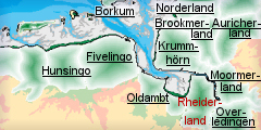
Delimitation: |
River Ems, Dollart Bay,
German-Dutch border, neighbouring entities Oldambt in the Netherlands,
Krummhörn, Moormerland and Overledingen in Germany |
|
Size: |
around 650
km² |
|
Location
- map: |
East Frisia in Lower
Saxony, Lower Saxony, Germany |
|
Origin of name: |
not known |
|
Relationship/similarities with other cultural entities: |
Similar natural landscape
to the neighbouring cultural entities around the Dollart Bay, however
the cultural landscape is similar to the other neighbouring entities
in Lower Saxony (Krummhörn, Moormerland). |
|
Characteristic elements and
ensembles: |
Marshland villages,
polders and straight drainage-ditches, terps and mound villages,
linear villages built on dykes, brick manufacturing, area of polder
princes. |

2. Geology and geography
2.1 General
The Rheiderland, sited between the Ems, the Dollart and the German-Dutch
border, is one of the four historic communities of the administrative
district of Leer, together with the Overdingerland, the Moormerland and the
Legenerland. Nowadays the German side of the region Rheiderland is composed
of the communities Weener,
Jemgum and
Bunde as well as
Bingum, a part of the city
of Leer. From north to south the Rheiderland stretches 30 km from
Pogum to
Halte. At the widest point,
between Dollard and Bingum,
the region measures 20 km. The Dutch part (Reiderland) is located in the
Dutch province of Groningen and is described in the cultural landscape unit
of Oldambt.
The northern part of the Rheiderland is marshland, whilst the southern part
is characterised by embankments of the River Ems and an accompanying sand
ridge. Geologically the landscape is derived from sedimentation layers and
the development of peatlands due to the rise of the sea level after the Ice
Age. Due to marine incursions, not only the low lying land but also the
shore land occasionally proved unsuitable for human settlements.
2.2 Present landscape
Rheiderland is a plantation-landscape, almost without relief, which thanks
to alluvial marsh soil is very fertile. At present the landscape is
characterised by its marshland villages and straight drainage-ditches. These
marsh landscapes and polders, new territory gained by erecting dykes around
marshes, are characteristic of the East Frisian landscape. Feature of this
landscape are the small number of trees and the far reaching panoramic view
to the horizon.
The farmers used to be wealthy, which is still mirrored today in the
splendid single farms. In the
Christian-Eberhards-Polder for instance there are wonderful single farm
complexes surrounded by water with their own names, whose owners used to be
called “Polder Princes”. On the newer polders are found linear villages
along roads and dykes with a dense ditch system.
The northern part of the Rheiderland was regained from the Dollart by means
of numerous dykes and is very fertile because of the marsh soil. The Dollart
originated in its present shape in the Middle Ages due to a number of storm
floods. Today this roughly 100 km2 sized bay is connected to the North Sea
by the Dollartmouth. During the 18th and 19th centuries there were numerous
attempts to gain new territory, which can still be seen in the present
landscape. Dykes and marshland alternate. The settlement form is mainly that
of linear villages built on dykes. Some marsh farming land is up to 1m below
sea level and is used for grazing. In the south of Rheiderland there are
peatlands, including the tail end of the Bourtanger Moor, which is located
in the Emsland and only partially survives.
The historical structure of land use, with main settlement-concentrations
inland along the old trade route Groningen-Bremen has hardly changed.
3. Landscape and settlement history
The large scale investigation of the North German mud flats and the
Rheiderland marsh, by the Archaeological Service of the East-Frisian
Association (Ostfriesische Landschaft) and the Institute for Historic
Coastal Research among others, has added considerably to our understanding
of this area.
3.1 Prehistoric and Medieval Times
Archaeological finds demonstrate that roughly 7.000 years ago Mesolithic
hunters and gatherers frequented the landscape of the lower Ems consisting
of peatlands, marshes, rivers and sand islands. In the Neolithic period
settlements of the Funnel Beaker Culture developed in the area. It was only
at the end of the Bronze Age that the marshes along the Ems were colonised.
Important excavations have been undertaken in the Iron Age settlements of
Jemgum and Hatzum. Farms
were built in the Roman period, and trading centres developed on the
elevated embankments of the Ems on tidal channels. The danger of storm
floods led to the creation of the first dwelling mounds.
The Rheiderland was settled very early and continuously by Frisians. The
settlements in the south, were located on the sandy soil, and in accordance
with the prevailing conditions, spread out along the banks of the Ems and
into the marsh. Settlement layers in both terpen and graveyards close to
Oldendorp (7-9th century)
are proof of later early medieval settlements. On the terpen village-like
settlement groups developed. In the later Middle Ages the building of dykes
led to a further heightening of the terpen with the additional material.
With the additional security afforded by the dykes, inland colonisation took
place with the expansion of settlements into low lying lands. In addition,
the bogland in the southern Rheiderland was made usable, for example in
Weenermoor and Wymeer,
where narrow long strips of farmland, in accordance with the Upstreek-law
were extended into the bogs, reaching lengths of more than a kilometre. The
trade- and craft-settlements of Jemgum and Hatzum developed as villages with
narrow streets on long terpen.
Well-fortified tower houses made of brick testify to the expulsion of
foreign rulers from Friesland in the 13th century. As a result the
Rheiderland, like the other Frisian areas, formed an independent
self-governing territory with a council constitution. Feudal rule was
unknown in these provincial communities. The principal places at the time
were probably Weener and Hatzum.
In the Middle Ages the Rheiderland was oriented towards the west and
Groningen’s Ommelande. Only since the breakthrough of the Dollart (in 1362)
which led to areas of the Rheiderland being flooded and forming a natural
border to the Ommelande, did the land communities turn more strongly to the
Frisian areas to the east of the Ems.
The origin of the Dollart goes back to several storm floods and inroads made
by the sea which caused constant land loss on the Dollart. The eastern
Dollart bay in the Netherlands was formed in the first half of the 15th
century. By 1454 an emergency dyke was constructed to protect the Oldambt,
leading from the stable banks of the Ems straight through the peatland area
up to high Geest near Finsterwolde. The western bay may have only originated
in the 1460s. In 1509 the Cosmos and Damian Flood penetrated far inland,
covering many areas of the Rheiderland with marine clay. The sea bay, which
had advanced as far as the gates of Ditzum, flooded four towns, 46 villages
and killed several hundred thousand people. However, the exact year of its
origin is not certain.
3.2 Early Modern Times
From the end of the 16th century, the systematic recovery of land began with
the construction of polders, which led to today's coast line. Between the
17th and the 20th centuries numerous other polders were constructed so that
now the Dollart has shrunk to one-third of its original size. The following
polders deserve mention: the Bunderpolder of 1707, the
Bunder-Interessenten-Polder, the
Landschaftspolder and
Preusspolder of 1744 and 1752 and the
Heinitzpolder of 1755. The
most recent is the Kanalpolder
surrounded by dykes in 1877 on the eastern side. The dykes and
drainage-systems of this time still exist in today’s landscape, although
they are now far inland.
The economic significance of the polders is still clearly visible in the
large gulf-houses. The whole of the Rheiderland was primarily devoted to
agriculture and the land reclamation work became especially intensive in the
middle of 18th century, due to the grain prices being high.
Ditzum was important as a
port. However reduced yields and competition from producers from abroad
reduced profits, causing in our days the closure of numerous farms. For the
people of the area nothing remained but to emigrate. Inland, some large
villages (Weener, Bunde, Stapelmoor) with churches dating to the 13th
century developed out of linear farm settlements.
From 1413 the Rheiderland came under the administrative rule of the ruling
family Tom Brok and then to the family Focko Ukena and then the family
Cirksena. The land communities only gained their autonomy once again for a
short time. The Rheiderland became a part of the country of East Friesland
and has shared its fortunes ever since.
In 1735 the German part of the Rheiderland was a part of the department of
Emden and Leer, divided into the Bunder, the Weeniger, the Bingumer, the
Jemgumer and the Dietzumer Protectorates. Then in 1859 only the departments
of Weener and Leer, which became independent administrative districts in
1932 existed. The administrative district of Weener was dissolved by an
order of the Prussian state ministry and was united with the administrative
district of Leer.
3.3 Modern Times
The appearance of the Rheiderland underwent major changes in the 19th and
20th centuries when the Ems clay was excavated for the brickyards situated
outside the dykes. Brick production influenced the further economic
development of the region considerably. In order to extract clay numerous
tracts of land were lowered by 1m. Bricks are still formed and fired, as
they were in the past, from this clayey soil. Many of the typical brick
buildings of East Friesland are built from Rheiderland bricks. Nevertheless,
this could not prevent many brick manufacturers closing for economic reasons
and being left to decay.
Agriculture is another important area of employment. The very fertile soil
is still present. However, the area used for agriculture has dropped by
nearly 2% during the last four years. Agricultural production is generally
decreasing.
The construction of the motorway A31 caused far reaching changes in the
cultural landscape. A west-east connection already existed during the time
of the Hanse (around 1500) as a trade route between Groningen and Bremen.
This trade route appears around 1863 for the first time as an Oldenburg
state road on maps.
However, the Rheiderland was not only cut in two by the extension of the
motorway, but this also led to changes in infrastructure. The expansion of
the residential areas and industrial areas in many places has contributed to
the loss of the formerly typical settlement pattern. Traditional settlement
forms such as the North German linear settlements or closed marshland
villages along the Ems are to be found less and less in the region.
4. Modern development and planning
In its regional planning report for 2005 the Federal Office for Building and
Regional Planning lists the Rheiderland as a region which is marked by
economic growth. This development has led and will lead to an increased use
of space for settlements, which is accompanied by traffic growth.
4.1 Land use
The Rheiderland has the appearance of a plantation-landscape, shaped by
unfavourable natural and economic conditions. In view of the intensive
agricultural use of the marshy soils it can be assumed that farms sizes will
increase to the disadvantage of other farms. Marshland used for arable
farming is mainly on the Dollart; in the north of the Rheiderland meadowland
marshes prevail and in the south there are valley meadows and moor geest. At
present, the proportion of people employed in agriculture is under 34 % and
will decrease even further during the course of future rural developments.
This development is to be seen in connection with the intensification of
agriculture which will, in view of the world-wide competition, lead to the
enlargement of farms and to the adaptation of land use to economic
constraints.
Aspects of the Rheiderland concerned with nature protection are apparent in
the form of designated nature reserves. The Dutch part of the Dollart has
been under nature protection since 1977 and has been a Ramsar-area since
1990. In 1980 the German part of the Dollart, which covers about 30% of the
Dollart, was declared a protected area, provided it belongs to regional
district Leer/ East Frisia. In the Rheiderland, the protected area of Saint
Georgiwold and the nature reserve of Wymeer with its idyllic peatland can be
found.
4.2 Settlement development
The traditional, rural settlement forms of the 19th century in the western
Rheiderland are linear settlements in the form of marsh or peatland villages
as well as villages along roads. However, further to the east along the Ems,
this typical settlement form is replaced by scattered villages. The
characteristic form of the villages on dwelling mound only appears in the
north of the Rheiderland. In the entire Rheiderland you find Frisian
gulf-houses, so important from the point of view of cultural history.
Today the administrative district of Leer is marked by relatively low
population-density, it is about 90 inhabitants per km². The construction of
the motorway A 31 simplified and improved the accessibility of the
Rheiderland and therefore the mobility of the people living in the
Rheiderland. Nevertheless it is still beyond the catchment area of Emden.
The commuter flow to Leer is limited and negligible.
The Rheiderland as a place to live, contrasts with the North Frisian coast
as a tourist area, the quality of which is based on the traditional,
agricultural use of the land and on the mud flats. Although the visitor
figures do fall from the north to the south considerably, the peak values
still amount to approximately three million overnight stays per year.
The Rheiderland does not have either a state museum or a trans-regional one.
There are two local museums in Bunde and Weener. In addition there is a
monastery dating from the Middle-Ages in Jemgum and the monastery of
Dünebroek. The region is
also known for its large number of important churches, e.g. the Church of
the Holy Cross in Bunde,
the "polder church" in the
Landschaftspolder or the oldest church in Midlum (around 1200) and the
oldest bell tower (13th century). The church-organs, which are especially
striking, were bought centuries ago by the communities and have been
preserved to this day. The most significant one is the Arp Schnitger organ
in St George’s church in Weener.
The Rheiderland, as a historic area with its own cultural history, is home
for many Frisians in whose consciousness the Rheiderland is strongly rooted.
This is made clear by local associations, by Rheiderland having its own coat
of arms (referring to Frisian autonomy), its own newspaper (Rheiderland –
the independent newspaper) and by the companies whose area of influence
takes in the whole of the Rheiderland (Ems Dollart Post).
4.3 Industry and energy
There are no significant industrial sites in the Rheiderland. Although Emden
and Leer are important sites for industry, only the construction of vehicles
is of significance here. In addition there are gas-pipelines which run from
north to south along the motorway and east to west from Groningen to
Oldenburg, Bremen and Hamburg. Further underground gas-reservoirs are
planned in Jemgum and Holtgaste. The numerous wind farms are among the
latest developments which have thoroughly changed the original appearance of
the flat land thoroughly.
4.4 Infrastructure
Traditionally the Rheiderland was accessed in terms of traffic by water and
roads (long-distance roads; motorway). Diverse harbours facilitate the
crossing of the Ems. Furthermore the line Emden-Dietzum-Delfzijl operates in
summer. Other former sluice-harbours, which were used to ship bricks from
the brickworks, are now used by sports boats and leisure cruisers.
The motorway connecting the Rheiderland to Lower Saxony and the remainder of
the German traffic-network was opened in the 1990s. The settlement picture
of the region was changed considerably by the completion of the motorway
A31. With a use of about 10.-20.000 vehicles per 24 hours, four
motorway-accesses and a well designed country road-system the whole area is
well developed. This is reflected in the mobility of the people of
Rheiderland who can reach the arterial routes of Germany in a short time.
Moreover the connection to the Dutch A7 to Groningen also plays a part in
local access.
The railway connection of Rheiderland from the Netherlands to Overledingen
was built by 1876. The north to south connection from Emden via Leer and
Papenburg to the Ruhr area, built in 1854, also played a big role.
5. Legal and spatial planning aspects
Administratively Rheiderland is divided into the communities of Weener,
Bunde and Jemgum as well as of Bingsum, a part of the town of Leer which are
all subordinate to the administrative district of Leer. The largest place is
the town of Weener. From 1885 to 1932 the administrative district of Weener
existed, which included the entire Rheiderland. In their present form the
communities of Bunde and Jemgum originate from the fusion of communities and
villages in 2001.
According to the regional planning programme of Lower Saxony the Rheiderland
is classified as a weakly structured area without centres. The next
middle-sized centres are Leer and Emden. From a regional planning
point-of-view the Rheiderland is part of the Regional Structure Conference
of East Frisia, which has not yet submitted a development concept. The
Regional Council of the east Frisian Area (Landschaftsverband Ostfriesische
Landschaft) extends over the entire governmental district (administrative
districts of Wismund, Aurich, Emden and Leer). In addition there are the
outline plans for the area and plans concerned with the utilisation of land
of the communities as well as the development plans concerning the coast
line of Lower Saxony.
6. Vulnerabilities
6.1 Strategic Planning
The opening of the motorway in the 1990’s has created easy access to
Rheiderland and will potentially lead to development pressure. Any strategic
planning for future development will need to have both the natural and
cultural heritage integrated into any decision making.
6.2 Settlement
The historic settlement pattern is important within this area and is
vulnerable to the threat from development within the core and expansion
around the perimeter especially if tourism continues to expand. The historic
farmsteads are already vulnerable to change of use away from traditional
agricultural production.
6.3 Agriculture
In view of international competition, the pressure to use all land optimally,
resulting from globalisation, will mean adjusting the means of agricultural
production to economic constraints. In this context the agricultural use of
the marsh areas is problematical, as the areas are fragmented by numerous
ditches and drains, consequently modern machines cannot be used. An
additional factor is the reduced deployment of yield increasing measures in
accordance with the European RAM acre-guideline. The enlargement of the
production areas leads to many farms being abandoned and to the
disappearance of traditional, small farms.
6.4 Tourism
The growing dependence of the Rheiderland on tourism can lead to an erosion
of the cultural heritage of the area. For many people in the area tourist
activities are an alternative to the non profit making agriculture they have
abandoned. This has resulted in historic farm complexes and agricultural
practices being lost to the needs of modern mass-tourism. It is essential to
identify ways in which both the tourism can be promoted but still retaining
the cultural history both in the landscape and structures. The lack of a
state or trans-regional museum within Rheiderland could restrict the
promotion of the areas cultural heritage.
6.5 Industry and energy
The increase in renewable energy production, such as wind farms, has a
significant impact on the historic open landscape. In addition, it has a
negative influence on the varied bird-life of the mud flats, causing many
birds to be killed by the rotor blade movements. These changes to the
landscape have a negative effect on both the natural and cultural-historic
landscape of Rheiderland.
7. Potentials
7.1 Settlement
The historic settlement pattern and its associated landscape is important
within this area and has potential for being a resource to encourage tourism.
Careful integration of the cultural heritage into planning proposals
provides the potential both for the preservation and management of the
historic settlements. The marshland villages of the 12th century show a
visible history and tradition of the Rheiderland; and are a strong link for
the Frisians with their home country. The historic farmsteads have the
potential to promote local agricultural production as well as to be
carefully used as tourist accomodation.
7.2 Agriculture
Agriculture has been the main historic economy for this area and remains so.
The area has not suffered as badly as other areas through intensification
and many of the historic monuments associated with agriculture survive
within the landscape. These have great potential to be promoted, protected
and managed via tourism and protection via agricultural schemes. These
features tell an important story for the development of this area and their
value should be identified both to the local population and the incoming
tourists.
7.3 Tourism
Beside the strong identification of the Rheiderland people with their native
land, the cultural history of the landscape can be promoted as a tourist
attraction. Thus the numerous dykes show the many century-old history of
dyke-building. Now that the dykes are inland it is possible to illustrate
this type of land reclamation by means of walks and excursions on the dykes.
In this fashion the tourism trade which already exists could diversify,
focusing on the cultural landscape of the Rheiderland. The museums can be a
further source which can promote the history of the Rheiderland.
7.4 Nature Conservation
There is potential for the cultural heritage to be incorporated within
management plans in those areas protected as nature reserves.
7.5 Industry and energy
The historic brick making industry within Rheiderland can become a centre
for the production of traditional building material and a possible tourist
attraction.
7.6 Infrastructure
Within Rheiderland there is excellent linkage in the regional and
trans-regional transport infrastructure as well as in an existing tourist
infrastructure, which has been operating for many years. There is the
potential to exploit this infrastructure to promote the cultural heritage of
the area.
8. Sources
Author: Meike Levin
Behre, K.-E. (1995): Die Entstehung und Entwicklung der Natur- und
Kulturlandschaft der ostfriesischen Halbinsel. In: K.-E. Behre, K.-E. & van
Lengen, H. (Hrsg.): Ostfriesland. Geschichte und Gestalt einer
Kulturlandschaft. Aurich 1995 (durchgesehene 3. Aufl. 1998), 5-36.
Behre, K.-E. (1999): Die Veränderungen der niedersächsischen Küstenlinien in
den letzten 3000 Jahren und ihre Ursachen. Probleme der Küstenforschung im
südlichen Nordseegebiet 26, 1999, 9-33.
Brandt K. (1977): Die Ergebnisse der Grabung in der Marschsiedlung
Bentumersiel/Unterems in den Jahren 1971-1973. Probleme der Küstenforschung
im südlichen Nordseegebiet 12, 1977, 1-32.
Bundesamt für Bauwesen und Raumordnung (BBR) (2005): Raumordnungsbericht
2005. Berichte 21, Bonn.
Raumordnungskonzept für das niedersächsische Küstenmeer. Herausgegeben vom
Niedersächsischen Ministerium für den ländlichen Raum, Ernährung,
Landwirtschaft und Verbraucherschutz – Regierungsvertretung Oldenburg –
Landesentwicklung, Raumordnung. Stand 2005.
Schwarz W. (1995): Die Urgeschichte in Ostfriesland. Leer 1995.
Schwarz W. (1995): Archäologische Quellen zur Besiedlung Ostfrieslands im
frühen und hohen Mittelalter. In: Behre, K.-E. & van Lengen, H. (Hrsg.):
Ostfriesland. Geschichte und Gestalt einer Kulturlandschaft. Aurich 1995
(durchgesehene 3. Aufl. 1998), 75-92.
http://www.nordwestreisemagazin.de/Rheiderland/
http://de.wikipedia.org/wiki/Rheiderland
http://nibis.ni.schule.de/~hsweener/helfen.html
http://www.genealogie-forum.de/ostfrld/kirchen/regionen/leer/rheiderland.htm
http://www.rheiderland.de/
http://www.jemgum.de/
http://www.gemeinde-bunde.de/
http://weener.conne.net/
http://www.nordwestreisemagazin.de/auswahl.htm
http://de.wikipedia.org/wiki/Dollart
|