|
1. Overview
|
Name: |
Spiekeroog |
|
Delimitation: |
The island of Spiekeroog is situated in the
Wadden Sea of Lower Saxony. The administrative border lies at the line
of the average high tide (MThw). |
|
Size: |
Approx. 18,3 km² (administrative district
of Wittmund) |
|
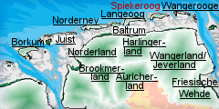
Location
- map: |
One of the seven islands in the Wadden Sea
of Lower Saxony Spiekerook lies between the islands of Langeoog and
Wangeroode. The island community Spiekeroog is one of six communities
in the district of Wittmund, federal state of Lower Saxony. |
|
Origin of name: |
The origin of the name Spiekeroog has been
disputed and there have been many attempts for interpretation. Today
it is assumed that the syllable „Oog“ can be translated as island. The
word “Spieker” probably derives from the old-saxon word “Spick” which
means storage. According to tradition Spiekeroog was used by the
mainland dwellers as a “storage island”. |
|
Relationship/similarities with other cultural entities: |
Frisian Islands, Islands
of Lower Saxony, dune landscape, maritime landscapes and settlements. |
|
Characteristic elements and
ensembles: |
Barrier island, dune landscape, tree
groves, Friesian building-types (Suderloog). |

2. Geology and geography
2.1 General
Spiekeroog is one of seven East Frisian Islands off the coast of Lower
Saxony and is sited in the c. 2780 km² large national park Niedersächsisches
Wattenmeer.
The island has a length of 9.5 km from west to east and a north-eastern
width of almost 2 km. It lies 5.7 km off the mainland.
Spiekeroog is one of the barrier islands and has developed in the course of
the interaction of wave energy and tidal range. Barrier islands originate
from periodically flooded sand plates and develop first into flood-free
beach banks and then into dune-covered islands. An important part of this
process is the blowing of sand from the wet beach which initiates dune
formation.
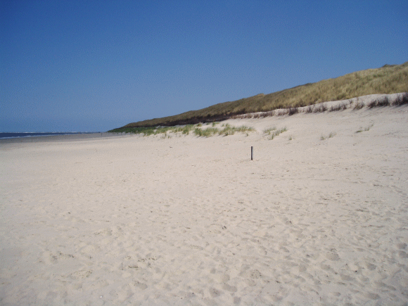 |
| Beach and dunes on Spiekeroog
© G. Lüerßen |
2.2 Present landscape
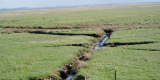
At present, Spiekeroog, is a dune-covered island affected by the steady
interaction of low and high tide. To the south of the island are the
mudflats of Lower Saxony. The islands are separated by deep tidal inlets,
known as the Seegats.
The continuing destruction of the western part of the island shows that
Spiekeroog is still subject to constant change. The reason for this is the
west-east sand drift which is induced by the interaction of the tidal
currents on the one hand and the prevailing westerly winds on the other
hand. The currents cause sand erosion in the west and sedimentary deposition
to the east, e.g. on the eastern Tipp of Spiekeroog reefs break loose which
then move in an arc (Riffbogen) to the neighbouring island of Wangerooge to
the east and deposit their sands in the middle or the east of that island.
Efforts are being made to slow down this morphological process (morphogenesis)
and to secure the western head of Spiekeroog by constructing large-scale
protective measures.
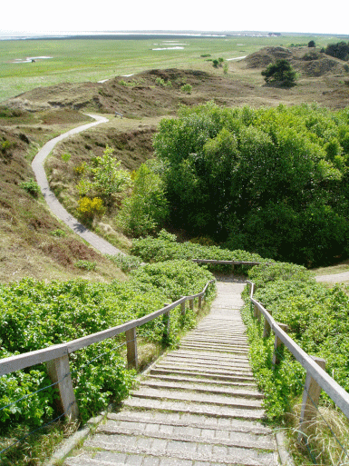
Spiekeroog is known as a green island with many groves of trees, including a
large number of trees within the settlement areas. Dunes, dune valleys and
salt meadows are characteristic natural landscape elements of every East
Frisian North Sea Island. The main western part of Spiekeroogs (some 4.5km
long) is covered by dune complexes and salt meadows; in the transition areas
between them the settlement is located. The remaining 5 km are taken up by
the large sand plate with wide dune areas and salt meadows.
The village of Spiekeroog lies on the southern side of the island which
faces the mainland. Clinker streets and low red Frisian houses dominate the
face of the village.
3. Landscape and settlement history
3.1 Prehistoric and Medieval Times
In the course of the post-glacial period and the melting of the ice sheet,
the North Sea reached the present-day coastal line by c. 5500 B.C. The
transgressive North Sea, under the influence of waves and tides pushed a
seam of sand in front of it, which progressively increased in size. This
barrier zone of sand supplied the material for the sand plates which largely
evolved in the slipstream of Geest cores and later developed into true
barrier islands, the predecessors of today’s dune islands. On the former
beach bank systems and higher sand plates Spiekeroog developed, as one of
the barrier islands which align like a string of pearls from the west to the
east. This process is still active today and induces a high natural dynamic
to the natural space of the mudflats.
As a consequence of the geological development of Spiekeroog, all remains of
Palaeolithic and Mesolithic human activity, like settlement remains, burials
etc., are covered by younger sediments and surface finds are not to be
expected. But it can be assumed that the area now occupied by the island of
Spiekeroog was also inhabited in prehistoric times. Archaeological finds,
however, would be buried deep beneath the sediments which would make it
almost impossible to discover and retrieve them today.
According to the chronicles Spiekeroog was only settled in medieval times,
it was first mentioned as „Eyland Spickeroch“ in a document of 1398. In
medieval East Frisia the influence of the Old Saxon language extended to the
Geest ridge while in the marshes and on the islands the Frisian dialect
prevailed. This makes it quite likely that the Anglo-Saxon name Spick was
transferred to the island without consideration of its true meaning.
Spieke-er-oog therefore would mean Island of Spick in which Spick would mean
store, albeit one which was not situated on the main land. The assumption of
the existence of such a place called Spick near the present island of
Spiekeroog is not improbable. During the course of the collapse of the
Harlebucht in early medieval times the mainland in front of Spiekeroog up to
the Geest ridge was largely destroyed, including probably the original
island of Spick.
3.2 Early Modern Times
To the first settlers of medieval and early modern times the island must
have presented itself as a barren dune landscape with only sparse vegetation.
They were caught in an incessant fight against a hostile environment. On the
one hand there was nature with its storm floods and sand storms and on the
other hand they had to defend themselves against attacks and pillaging which
continued until the 16th century.
Next to fishing and sheep farming, salvaging flotsam and jetsam was a
further important source of income. Based on old settlement traces,
discovered in 1832, it is assumed that in the time before the 17th century
an older village existed in the west of the island. However, nothing is
known about the circumstances of its foundation or abandonment.
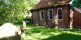
The oldest restored East Frisian Island church, which is found on
Spiekeroog, dates back to 1696. At this time the island was 5.2 km long and
1.6 km wide. Besides the main island, there existed two smaller islands: „Lütjeoog“
(today’s Lütjeoog-Dünen in the Westergroen) was sited south of the main
island while „Oldeoog“ lay in the east on a plate between the tidal inlets
„Alte Harle“ and „Harle“.
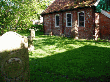 |
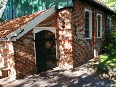 |
| Spiekeroog church © G. Lüerßen |
|
Until the construction of the stabilised banks on Spiekeroog the western
coast of the island drifted annually ca. 3.5 m eastwards; between 1650 and
1850 it travelled a total of c. 900 m.
3.3 Modern Times
Napoleon’s Continental System of 1806, which was supposed to prevent trade
between the continent and the British Isles, also disrupted the seafaring
activities of the people of Spiekeroog. Thus the main source of income of
the island dwellers ran dry and the population quickly sank into poverty.
Since the number of inhabitants then declined it is assumed that many
inhabitants left the island during those years. From 1850 on the number of
inhabitants of Spiekeroog has again steadily increased.
Little is known about the origins of Spiekeroog’s development into a seaside
resort. Towards the end of the 19th century, when the fishermen of
Spiekeroog began to feel the impact of the competition from deep-sea fishing,
new sources of income had to be considered and people began to let rooms to
visitors. In the first years of the 19th century spa visitors began to
frequent Spiekeroog and in 1846 the island was first mentioned as a seaside
resort. In 1849 there were already c. 80 beds for guests available but they
were still considered to be more of a sideline.
Until about 1880 seafaring was the main source of income for the island
dwellers and the development of tourism only commenced slowly. But towards
the end of the 19th century the number of spa visitors began to rise
continuously. However, the simple task of reaching Spiekeroog proved
difficult. It took two days just to get from Emden to Spiekeroog. In 1891
the first landing stage was built so that guests didn’t have to any longer
directly climb from the ferry into a horse carriage.
Today Spiekeroog is called “The Green Island”, due to its many groves of
trees. But until the middle of the 19th century the dune areas of Spiekeroog
were still covered with white sand drifts, the vegetation canopy was not
closed yet and there were no trees. Only a change in the living conditions
led to a greening of the island. After the planting of beach grass, the
banning of grazing domestic animals in the dunes, a ban on the cutting of
beach grass as fodder or bedding, and the extermination of rabbits (hares
were released instead), the paving of paths and the planting of trees did it
finally became possible on Spiekeroog for a relatively undisturbed island
vegetation to develop.
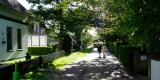
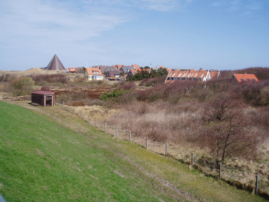 |
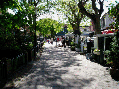 |
| Village of Spiekeroog
© G. Lüerßen |
Main street in the village of Spiekeroog
© G. Lüerßen |
4. Modern development and planning
The island of Spiekeroog belongs to the district of Wittmund and is
therefore subject to the regional planning of the federal state of Lower
Saxony. The basis for this is the Law for Regional Planning and Land Use
Regulation (NROG) and its Supplemental Administrative Regulations (VV-NROG)
of Lower Saxony. The aims and principles of the land use planning are
defined in the Regional Planning Program of the Federal State of Lower
Saxony (LROP). The LROP forms the basis of the Regional Planning Program of
the Administrative Districts (RROP).
According to the regional planning report of 2005 of the federal office of
building and regional planning Spiekeroog lies in a region in which the
development of the population and employment is characterised by a
significant growth. Since the middle of the 19th century this growth bases
economically on the expansion of the tourism.
4.1 Land use
There is no intensive agricultural usage on Spiekeroog. Neither does fishing
play any longer any significant role for the island dwellers, having ended
as a significant economic factor in 1900.
Since 1986 the island has been part of the national park Niedersächsisches
Wattenmeer and divided into three different protective zones of varying
intensity: Protective zone I (= quiet zone) has the strictest usage
regulations. Here the protection of animals and plants takes priority. It
may not be accessed „cross-country“ but only by hiking-, riding- and cycling
paths which give visitors the chance to explore and enjoy nature without
disturbing it. Protective zone II acts as buffer zone (= intermediate zone)
and, like a coat, encloses the more strictly protected area. In the
intermediate zone the main goal is to preserve the impression of the typical
landscape. It may be accessed freely but like in the quiet zone it is
prohibited to pick plants or take away any thing which is part of the
natural environment. In the salt meadows of the intermediate zone protected
bird species breed from the beginning of April till the end of July. These
areas are specially marked. During the breeding season they may only be
accessed by the paths. Protective zone III comprises the remaining parts of
the national park with only slight regulations (= recreational zone). This
quiet area acts as recreational area for human beings; e.g. no motor powered
appliances are allowed here. Within the landscape the borders of the
national park and the different protective zones are marked by blue signs
with white writing.
In contrast to this is the role of tourism on the Spiekeroog landscape. The
main focus of tourism on the island is for recreation in close communion
with nature. Besides the natural and near-natural, island areas with their
typical relief and corresponding characteristic vegetation the village of
Spiekeroog has to be mentioned as well. The clinker-paved streets and the
red, low Frisian Houses gives the impression of a self-contained island
world which has managed to preserve its character.
There is a continual work on coastal protection for the island. The western
end of Spiekeroog is secured by a protected area of an overall length of 1.6
km with 13 groins, 1,500 m of bank stabilisation, a ca. 800m-long sheet pile
wall and a substantial tetrapode embankment.
4.2 Settlement development
The population figures of Spiekeroog have not changed significantly during
the last 15 years. There are c. 825 people living on the island today.
The most important source of income in the region is tourism. During the
last two decades the number of long-term visitors almost tripled from a
20.000 to nearly 60.000. Hotels, holiday flats and a camping site are
available on the island. For example there is the marketing company „Die
Nordsee – Sieben Inseln eine Küste“ which organises recreational as well as
active holidays on the East Frisian Islands and on the North Sea coast. In
addition thereof the „Ostfriesland-Tourismus-GmbH“ (OTG) was founded by the
end of October in 2004 which in turn was inspired by the “Touristisches
Leitbild und Entwicklungskonzept für den Raum Ostfriesland“ (touristic model
and development concept for the region of East Frisia).
On Spiekeroog there is no State- or supra-regional museum. The island museum
presents the history of Spiekeroog and its surroundings. In addition there
is the historic horse tramway which is the only surviving horse tramway in
Germany. A private shell museum and the island church also welcome visitors.
The church from 1696 is the oldest East Frisian Island church. In it there
is a Renaissance pulpit, a pietà and apostle pictures which probably were
rescued from a ship of the Spanish Armada which stranded off Spiekeroog in
1588. The old island house from 1705 is also worth seeing since it presents
the building style of the 18th century in an almost unaltered way. The most
remarkable feature of the house is its roof construction. During storms or
floods the inhabitants fled to the roof which could be easily detached from
the house and, in the case of a complete flooding, could drift to the
mainland like a ship. Chronicles tell about cases where island dwellers with
their roofs safely “anchored” well behind the dyke lines of the mainland.
4.3 Industry and energy
At present there are no industrial or wind energy plants on Spiekeroog.
But there are a modern sewage plant and a thermal power station as well as
waterworks. The waterworks tap into the underground freshwater lens for high
quality drinking water. The lens feeds on rainwater which collects
underneath the dunes in a freshwater reservoir. This process is essential
for the island and only makes it inhabitable in the first place.
4.4 Infrastructure
The horse tram, which was founded in 1896, was the last one in Germany to go
out of service in 1949 and was replaced by an island train with a diesel
locomotive which ran along a wider track. But the construction of a harbour
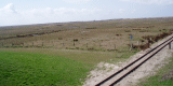
near the village rendered the service of the train, which was operated from
1949 to 1981, unnecessary. The old horse tram, however, still runs as a
museum train line across the island.
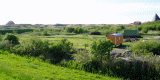
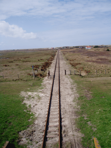 |
 |
| Museum
railway © G. Lüerßen |
View on eastern part of Spiekeroog © G. Lüerßen |
Currently Spiekeroog can be reached from Neuharlingersiel by ferry one to
three times a day, depending on the tides. The village of Spiekeroog
comprises about 350 houses and 27 streets. Cars are not allowed on the
island and bicycling is also almost completely prohibited. Electric cars are
used to transport heavy goods. But you can also rent or bring along a
handcart.
There are several public facilities in the village of Spiekeroog: including
three churches, two schools, one post office, several cafés and restaurants
etc.
5. Legal and spatial planning aspects
The community of Spiekeroog is sited in the administrative district of
Wittmund and belongs to Lower Saxony. With regard to land use planning, the
community is subject to the regional planning of the federal state of Lower
Saxony respectively of the landscape framework plan and the land use
utilisation plan of the community. In addition there is the regional
planning concept fort he coastal sea of Lower Saxony.
The community of Spiekeroog, together with other communities in the district
of Wittmund, is part of the Regional Structure Conference of East Frisia.
The territory of the community ends at the MThw line (line of the Average
High Tide). The coastal sea below the MThw line is a „community-free area“.
Accordingly, the regional and building plan only applies to the land but not
to the marine area.
The presently valid regional planning of the federal state of Lower Saxony (LROP)
contains only a few regional planning goals for the marine area. The area of
the national park is registered at the EU for the Fauna Flora Habitat
guideline (FFH) and therefore belongs to the biotope network system Natura
2000. The main part of the park lies within the territory of the EU water
withdrawal guideline. In 1996 the Wadden Sea area within the borders of the
national park was recognised by the UNESCO as biosphere reservation in the
context of the program „Man and Biosphere“.
6. Vulnerabilities
6.1 Tourism
The promotion of nature-oriented ecotourism may create a situation which
will alter the natural state of the island into an artificial-looking
structure.
6.2 Natural erosion
The continuing erosion of parts of the island will result in areas of
surviving cultural heritage monuments or buried archaeological deposits
being lost to natural processes.
7. Potentials
7.1 Settlement
The historic settlement on Spiekeroog still contains several of its historic
buildings set within a luxuriant stand of trees provides the potential both
for protection of the historic buildings and settlement layout and there
promotion via the tourist industry.
7.2 Tourism
Tourism should be orientated in the direction of nature-related tourism,
however, there is the opportunity to include the cultural heritage within
this and develop further tourism via the cultural heritage assets. Since
Spiekeroog is part of the national park special emphasis is placed on the
protection and preservation of these unique habitats and there is potential
for this to be expanded to protect and promote the cultural heritage of the
island.
7.3 Nature conservation
There is potential for the cultural heritage to be incorporated within
management plans for the nature conservation on the island. By creating
integrated management plans for both the natural and cultural environment
the islands potential for carefully managed tourism can increase.
8. Sources
Author: Franziska Grieß
Gemeinsames Wattenmeer Sekretariat (Hrsg.; 2005): Das Wattenmeer.
Kulturlandschaft vor und hinter den Deichen. Stuttgart.
Gutmann, H. (1990): Deutsche Nordsee-Inseln. In: HB-Bildatlas. Sonderausgabe
5. Hamburg.
Meyer-Deepen, H. und Meijering, M. P. D. (1970): Spiekeroog. Spiekeroog.
Maier, R. (1974): Ur- und frühgeschichtliche Denkmäler und Funde aus
Ostfriesland. In: Wegweiser zur Vor- und Frühgeschichte Niedersachsens 8.
Hildesheim..
Niedersächsisches Ministerium für den ländlichen Raum, Ernährung,
Landwirtschaft, und Verbraucherschutz – Regierungsvertretung Oldenburg –
Landesentwicklung,
Raumordnung (Hrsg.; 2005): Raumordnungskonzept für das niedersächsische
Küstenmeer. Stand 2005. Oldenburg.
Petersen, J. und Pott, R. (2005): Ostfriesische Inseln. Landschaft und
Vegetation im Wandel. Hannover.
Roterberg, P. (1983): Die Nordseeinsel Spiekeroog. Vom Fischerdorf zum
Nordseeheilbad. Hamburg.
Internet-Sources:
landkreis.wittmund.de
Status: 13. 02. 2007
nls.niedersachsen.de
Status: 12. 02. 2007
nordwestreisemagazin.de Status: 09. 01. 2007
rcom.marum.de Status: 09.
01. 2007
spiekeroog.de Status:
09. 01. 2007
windrose-spiekeroog.de Status: 09. 01. 2007
wittbuelten.de
Status: 09. 01. 2007
|