|
1. Overview
|
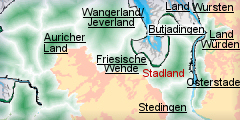
Name: |
Stadland |
|
Delimitation: |
River Weser, Jade Bay,
neighbouring entitiesy Land Butjadingen, Stedingen |
|
Size: |
Approx. 113
km² |
|
Location
- map: |
River marsh of Lower
Saxony, Germany |
|
Origin of name: |
The origin of the name
Stadland is not quite clear, it may derives from "Gestade" and
describe the coastal strip to the west of the Weser. |
|
Relationship/similarities with other cultural entities: |
River marshes of
Osterstade, Stedingen, Land Würden, agriculture, mainly grazing land,
rural house forms, linear settlements. |
|
Characteristic elements and
ensembles: |
River marshes, agriculture, grazing land, rural house forms, linear
settlements . |

2. Geology and geography
2.1 General
The Stadland is a community in the administrative district of Wesermarsch
and consists of the places of Rodenkirchen, Schwei, Seedfeld and
Kleinensiel. Today's form originated in the course of the administrative and
area reform of 1974. In the east it is delimited by the Weser and in the
west by Jade Bay. The main centre of population is Rodenkirchen which is
also the principal town and seat of the local government. The historical
landscape of the Stadland borders in the north roughly with
Eckwarderhörne-Nordenham on the Butjadingen, and in the south north of Brake
with Stedingen. Whilst the eastern Stadland is marked by a brackish marsh
with a slightly raised embankment on the Weser shore, a lake marsh had
formed on the side of Jade Bay. Southeast and south of Jade Bay as well as
on the geest edge there are marshes, low moors and high-level moors.
The Stadland is a river marsh area originating in the postglacial age, with
a typical division of landscape into an embankment up to a kilometre wide
along the river and the Sietland lying behind it. The embankment originated
as a deposit of mineral material from storm floods and high water. In the
low lying pastures there is a lack of sediments. The combination of the low
ground level and water logging led to the formation of the peat-bogs.
The origin of the name Stadland is not quite clear, possibly it derives from
"Gestade" and describes the coastal strip to the west of the Weser. In the
Middle Ages the Stadland was a part of the Frisian region of Rüstringen
which lost its territorial unity in disastrous storm floods. In 1367 the
communities of Rodenkirchen and Golzwarden were mentioned in a document as "terra
Stedingorum in Rustringia".
2.2 Present landscape
The Stadland is a flat countryside with hardly any relief. The river marsh
with an embankment along the western shore of the Weser, lined by dykes, is
cut through by sluices and drainage channels. Big floodgates provide both
irrigation and drainage. The only Weser island and landscape protection area
is the Strohaus Bank. The branch of the Schweiburg separates it from the
community of Stadland.
The Strohaus Bank possibly originated in the 16th/17th century, with the
combination of several sand banks and increased with the deposition of sand
during the course of the Weser correction in the 19th century. Most of the
island is used agriculturally. Two farms, that still exist nowadays,
continue to practice extensive grassland agriculture.
Inland, in the western Stadland close to Schwei, there are extensive, high
moor areas cultivated today. The Schwei Moor, as the Sehestedt Moor,
originally extended into Jade Bay. However, it was eroded by the sea and
reduced to its present size. Here the Sehestedt moor, outside the dyke, can
be seen as a geological natural monument. The high moor is located in front
of the dyke on the eastern edge of Jade Bay. The peat bog floats on the
water, the formation of the “Klappklei” linked with it can be observed from
the dyke. During storm floods, with heights of up 1.70m above Mean High
Tide, the moor opens up horizontally and clay is deposited in the resulting
cracks which develop in the body of the moor.
About 90% of the community surface is used agriculturally, mainly as grazing
land. The individual farms are usually dispersed outside built-up areas.
3. Landscape and settlement history
3.1 Prehistoric and Medieval Times
The investigation of the river marsh has been considerably advanced by the
work of the Institute of Historical Coastal Research in Wilhelmshaven. As a
geologically relatively recent landscape, the Weser Ems area is marked by
quaternary deposits.
The exact date of settlement in the Stadland cannot be determined
archaeologically. However, considering the situation in the surrounding area,
it is probable that the Stadland did not remain unaffected by the
prehistoric developments in the region. At the beginning of the post-glacial
age today's southern North Sea coast was dry land and the coast at that time
lay in the area of the Doggerbank in the North Sea. The river marsh of the
Stadland was presumably frequented by Mesolithic hunters. Traces of a
Neolithic population are absent in the Stadland; they are, however, proven
in the neighbouring administrative districts. It is possible that there are
sites beneath the river marsh with its subsequent millennia of sediment. It
is possible that work along the rivers, particularly the widening of
shipping channels, may expose cultural strata/layers which will then erode
unnoticed.
The first archaeologically proven settlement took place, according to
present knowledge, in about 900 to 300 BC. Only the embankment of the Weser
was originally settled. From the late Bronze Age single finds have been made,
which prove a human presence in the Sietland as well, e.g., an axe type
“nackengebogene Axt” from the moor near Schwei.
In 1971 the oldest settlement discovered up to now in a German marsh was
found to the west of Rodenkirchen, close to the mill of Hahnenknoop, some 2m
below to-days ground level and 1m below sea-level. Three houses of a lowland
settlement were revealed during excavations for the Strohaus sluice channel.
These were sited on the western embankment of the Weser on a slope facing
away from the river. Further excavations (1996-2001) of a house sited to the
north of the first discovery, by the Lower Saxon Institute of Historical
Coastal Research in Wilhelmshaven and who in collaboration with geologists,
archaeobotanists and archaeozoologists, have created a lively picture of how
the people around 900 BC used this landscape. People lived in tri-sectional
houses with byres, i.e. people and cattle lived under one roof. Cattle
provided the economic basis. Apart from that grain was cultivated in the
summer as well as nuts and berries being collected. The remains of casting
crucibles and moulds are significant as they prove that the colonisers of
the marsh could supply themselves with metal and also knew how to process
it. When settlement ended on the marsh is still unclear, it might have been
between 400 and 150 BC. The Weser river marsh became waterlogged, because of
inroads made by the North Sea and was therefore unusable as a farming area.
New settlement on the embankment occurred only in the first century AD.
Originally the settlements were built at ground level, the rising
storm-flood levels in the 1st century AD required the dwelling areas to be
raised on artificial mounds created by the piling up of clay and dung. It is
still unclear when the building of terpen on the embankments of the Stadland
exactly began. Roman finds have been found at three sites. To the south of
Rodenkirchen is Rodenkirchen-Wurth with farm-mounds and a medieval so-called
“Jedutenhügel”, a mound, whose interpretation is still disputed. Ceramic
finds prove the existence of a lowland settlement, possibly dating to the
first centuries AD, beneath all three places. The finds made at Knappenburg
are from the time around Christ’s birth, however the context of the finds is
unknown. In Rodenkirchen excavations in the interior of the church of Saint
Matthew proved that the church-mound is sited on top of the older
village-terp, which is dated to around Christ's birth or a little earlier.
In contrast to the neighbouring regions, the settlement history of the
Stadland in the early Middle Ages has not been archaeologically proven,
however it was probably similar to the developments in the neighbouring
Weser regions. During the migration period, in the 5th/6th century AD, the
settlement activity decreased strongly, although the latest investigations
reveal a fall of the sea level during this period.
Large-scale settlement activity can only be proven again from the 7th/8th
century. Once again the settlements are built at ground level, and later
with rising sea-levels they were again being built on mounds.
The first dykes, the ring dykes, were probably built in the11th century.
They were to protect the settlements, as well as the economic areas
immediately surrounding them. Only in the 12th/13th century were continuous
dyke lines built.
In the 11th century the areas of settlement were extended. They were
triggered by the inhabitants of the mounds, thus about 400m south-west of
the village-mound of Havendorf is the farm-mound of Havendorferberg.
Excavation has shown that the oldest settlement level is about 1.40m above
sea level and is a foundation dating back to the 11th century.
The oldest church foundation of Stadland is thought to be Saint Matthew on
the church-mound of Rodenkirchen. It is one of many churches along the
Weser, which were built from the sandstone of the Weser hills. Apart from a
possible timber-frame construction, the first to be made of stone dates from
the second half of 12th century.
Disastrous storm floods led to regional changes in the late Middle Ages.
Jade Bay was flooded in 1219 and 1287. The "Grosse Mantränke” (The Marcellus
Flood) of 1362 extended Jade Bay considerably and with the creation of the
Lock Channel a connection with the Weser emerged. The maximum expansion of
Jade Bay was in 1511 with the Antoni flood. The previous moor areas
decreased to the size of today's Sehestedt Moor outside the dyke.
After the chieftains rule in Frisia, and their expulsion in the spring of
1414, the Stadland became the property of the town of Bremen, thus ending
its autonomy. In 1514 Stadland with its five parishes fell to the Count of
Oldenburg. Since that time the history of the area is closely connected to
the house of the counts of Oldenburg.
3.2 Early Modern Times
In the 16th century the reclamation of land began in the area of Jade Bay.
In 1591 and 1643 the Lockfleth was finally closed. The “Seefeld“ was
reclaimed and made available for settlement. The church of Seefeld was
consecrated in 1676. The new villages were mainly linear settlements in the
immediate vicinity of the dykes. Roughly 200 years ago the peatland
colonisation began with the settlement on the bog with the
“Heuerlingsstellen” called workers lodges. It was only between 1721 and 1725
that a dyke was built over the Sehestedt Moor. By the end of the early
modern times the development of the marsh areas had progressed significantly,
so that in many areas the settlements and open fields had a similar
character as today although the social structure has changed. The
development of big farms has affected the appearance of the mound-villages.
3.3 Modern Times
The marsh has always been used for agriculture. In the “young marsh”
meadowland with pastures dominate. What once created wealth, is an
agricultural problem zone today. As a consequence tourism plays an
increasingly important economic role.
The settlement landscape has only changed slightly. There are isolated
centres of administration, which remain relatively small. The majority of
the settlements consist of long linear developments which are on the old and
new dykes as well as along the edges of the peatland. In addition there are
several dispersed single farms. Some places like Schwei or Rodenkirchen have
taken on the appearance of scattered villages. The meadow-fields of the
Stadland show a difference between the older and the younger fields. The
former comprise irregular block-meadows in the old colonised embankments,
these are also present in the area of the more recent Seefeld, which is
demesne land. The younger meadows are more regular in plan. This can be seen
in the strip-shaped fields in the newer marsh and the peatland areas. The
community of Stadland in its present form was formed in 1974 from the
formerly independent communities of Rodenkirchen, Schwei and Seefeld as well
as the farming community Kleinsiel. Rodenkirchen is the principal settlement
and the seat of local government. Nowadays there are roughly 8.000 people
living in the community. Of these approximately 4.000 people live in
Rodenkirchen, which is also the school and sports centre. Seefeld only
originated in 1643 when dykes were built and land reclaimed. The area is
predominantly agricultural with a cultural centre at Seefeld Mill. Schwei
has approximately 1.500 inhabitants. The smallest place with approximately
800 inhabitants is Kleinsiel, famous for the neighbouring nuclear
power-plant of Unterweser.
4. Modern development and planning
In its regional planning report of 2005 the Federal Office for Building and
Regional Planning classified Stadland amongst other areas in which the
development of the population and their employment is marked by stagnation
or a slow growth.
The designation of specific building areas with favourable property prices
has lead to the construction of detached family houses and thus to a slight
increase in the number of inhabitants in the villages. With its population
density of less than 50 to 100 inhabitants per km2, the Stadland is a thinly
populated area. Only on the Weser the density with more than 100 is a little
higher. The increased use of land for building and traffic is described as
being average, the development of traffic as being slight.
4.1 Land use
The Stadland is a classic river marsh area with embankments and low lying
pastures. On the embankments there is arable soil with a high yield. With
sufficient flood control the land is suitable for intensive agriculture.
However, the greater the distance from the shore, the worse the quality of
the land and the conditions for its use become. The soil gets heavier,
continual deposition of sediments leads to compression levels, which make
the grounds impervious and create waterlogging. Additional drainage and
fertilisation does however raise the yields. The Sietland with its marsh and
peaty soils is exclusively used as meadowland, because the ground-water
level is too close to the surface to permit arable use. Locally, in the area
of Jade Bay, the turf was covered with clay and then worked. The prevailing
farm economy is cattle pasturage with the keeping of dairy cattle- and fat
stock as well as cattle and some horse breeding, made possible by extensive
meadowland with a long vegetation period.
The river marsh area is practically without trees. The embankments have been
cleared since the beginning of settlement in the area and the peatland areas
have no trees. Thus the administrative district Wesermarsch with a
forestation-quota of only 0.7% can be described as being nearly empty of
woodland.
The main economic focus lies, except for agriculture, increasingly on
tourism. The number of the farms is decreasing steadily, as for example in
Schwei or Seefeld. Many farms have been converted, into holiday homes.
Nowadays, the proportion of people employed in agriculture is less than 14%
and it will fall with increased intensification and farm sizes, as well as
the adaptation of the area used to operational constraints.
In spite of the changes the original rural and craft culture has still been
preserved: Big old farms, green meadows with milk cows and roads with
avenues of trees bent by the wind make up the landscape.
4.2 Settlement development
Business commuter traffic is particularly vital for the marsh areas with a
little industry traffic to and from trade locations in the immediate coastal
regions such as Wilhelmshaven, Bremerhaven, but also with Bremen or
Oldenburg and to the neighbouring lower Weser harbours of Elsfleth, Brake
and Nordenham. The commuter-balance of 2004 is up to just below 25%. There
is little industry, apart from the nuclear power plant in Unterweser. The
characteristics of Stadland are low intensity as far as the establishment of
companies and weak development of opportunities for employment are concerned.
Stadland does not have a state or regional museum or even local museums. The
church of Rodenkirchen is a local attraction. In 1629 Ludwig Münstermann
created the altar, in 1631 the pulpit and in 1637 the grave inscriptions.
The church of Saint Secundus forms the focal point of Schwei. Here too L.
Münstermann created the altar, the pulpit and the cover of the baptismal
font.
In Seefeld the Seefeld mill has been restored and turned into a cultural and
event centre, which is organised by a cultural society. In the immediate
vicinity the floating bog of Sehestedt, a natural monument, can be admired.
The communication centre of the nuclear power plant at Unterweser has
meanwhile developed into a culture centre which regularly organises
exhibitions of paintings.
The “Bronze Age House Hahnenknoop” reconstructed the excavated house and
opened it to the public in 2005. The house is sited in a field behind the
mill of Hahnenknoop, south of the original settlement-area. In that way a
tourist attraction was created in a community short of museums. The
“Roonkarter Mart” which takes place every autumn in Rhodenkirchen, attracts
many visitors.
A sign-posted cycle track-network, 220 kilometres in length, which is
connected to the Weser-cycling route, offers tourist opportunities. In
addition the cycle path “German Floodgate-Route “ with a length more than
200 kilometres in length, runs through the administrative districts of
Wesermarsch and Stadland.
Along the Weser, close to Kleinsie,l there is an approximately one kilometre
long natural beach, which is going to be turned into a recreation area. A
camping- and caravanning site is being planned to upgrade the tourist
facilities.
4.3 Industry and energy
Despite improvements in traffic links there is a lack of industry coming
into the area, This is reflected in a relatively high rate of unemployment.
The nuclear power plant at Unterweser of Preussen Elektra is an industrial
centre, which is due to close in 2013 due to the agreed phasing-out of
nuclear power. Otherwise there are only isolated small and medium-sized
companies in the construction area, metal construction as well as trouser
manufacturing.
Close to Seefeld there is a large wind energy park. In the meantime numerous
wind turbines in the community have changed the appearance of the landscape
somewhat.
4.4 Infrastructure
The motorway-connections A 27 and A 29 can be reached on average in 10 or 25
kilometres from the historic unit of Stadland. The regional main traffic is
carried by the federal roads B 212 and B 437, as well as via the Weser
tunnel opened in January 2004 which should interconnect the economic areas
of the lower Weser better. The ferryboat-connection, which had existed since
1644 from Kleinensiel to Dedesdorf on the other side of the Weser, was
stopped in 2004 due the construction of the Weser tunnel. Country and high
roads are the other possible connections within the community.
The rail traffic between Bremen and Nordenham runs via Stadland with
possibilities of stopping at the railway stations in Rodenkirchen and
Kleinsiel.
5. Legal and spatial planning aspects
For geological / geographic reasons Stadland can be divided into three
segments:
1. the strip along the Weser with the main villages Rodenkirchen and
Kleinsiel which is mentioned in the land planning programme of 1969 as a
focal area,
2. western Stadland with Schwei and seven other farming communities which
are characterised by marshy soil, and finally
3. the region of Seefeld which was reclaimed by erecting dykes. Both these
regions are classified as specially weakly structured areas.
As far as regional planning is concerned, the Stadland community is subject
to Lower Saxony’s land planning programme or the regional landscape- or land
use planning programme put forward by the communities. In addition, in terms
of planning Bremen’s regional development concept of inner-state
co-operation is relevant.
For the period 2000 to 2006 the administrative district of Wesermarsch
belongs to Lower Saxony’s Aim 2-area of the EU’s – structural policy. At the
moment suggestions are being discussed for the support of rural areas for
the period 2007-2013. In accordance with these suggestions, sources such as
agriculture, tourism, crafts and businesses should become mainstays for the
rural economic areas. Already in 2001 the administrative district
Wesermarsch had presented its own concept for the development and
preservation of the historic area. On this occasion, small projects from the
areas of tourism, regional products, nature and culture should be promoted
and implemented. In addition, since 2004 the Wesermarsch is a project
partner in a trans-national project for the "Guidance of the Structural
Change in the Rural Regions of the North Sea Coasts Area “. Here questions
such as traffic and transport, economic development and social matters are
at the core.
Culturally Stadland belongs to the area of the old dukedom of Oldenburg and
is part of the historical area of Oldenburg.
6. Vulnerabilities
6.1 Strategic planning
The establishment up of intensive industrial zones and commercial areas
to improve the economic situation necessarily leads to disturbances of
traditional structures. However, up to now Stadland has been untouched by
such developments, apart from the industrial area "Hiddingen-Weserquerung"
and there should be the opportunity to integrate cultural heritage into any
strategic planning for the area. .
6.2 Settlement
Linear settlements along the roads and dykes as well as long slim
pastures mark the hinterland. The changes brought about by the building of
industrial zones, expansion of settlements and the attempt to strengthen
tourism makes the original settlement structure vulnerable to change.
6.3 Agriculture
The biggest problem for the preservation of the cultural landscape of
Stadland is the emerging change in the use of space. Above all this concerns
agricultural production and the search for new structures of employment,
which have already begun with tourism and which will intensify even more.
International pressure and the pressure of use resulting from international
competition will probably drag an adoption of the agricultural means of
production to economic practical constraints along. The reduction in the
number of farms – the so-called “dying of farms” – is the inevitable
consequence and can be seen already in some inland communities.
6.4 Tourism
Modern mass-tourism can lead to the loss of authentic structures. In
addition, necessary commuter movements could provide the loss of local
reference.
6.5 Industry and energy
The creation of wind farms has a direct impact on the visual cultural
heritage of the area.
6.6 Infrastructure
It is possible that work along the rivers, particularly the widening of
shipping channels, may expose prehistoric and medieval cultural strata/layers
which will then erode unnoticed.
7. Potentials
7.1 Settlement
Despite modern influences the cultural landscape of Stadland has been
able to retain its special character. Wide marshes prevail, in which the
single yards and villages stand out clearly on the dwelling mounds and even
today in combination with the dykes give it its distinct appearance. Linear
settlements along the roads and dykes as well as long slim pastures mark the
hinterland. Despite the changes brought about by the building of industrial
zones and the attempt to strengthen tourism, it is sensible to maintain
these structures. Careful integration of the cultural heritage into new
development proposals provide the potential to both protect and promote the
cultural heritage of the area.
7.2 Tourism
The increasing tourism in Stadland provides the opportunity to promote
the cultural heritage of the area. Careful conversion of redundant farms
provides the opportunity to retain the buildings. The cycle network can also
provide the opportunity for cultural trails through the area.
8. Sources
Author: Frank Both
Behre, K.-E., Ku?an, D. (1999): Neue Untersuchungen am Außendeichsmoor bei
Sehestedt am Jadebusen. Probleme der Küstenforschung im südlichen
Nordseegebiet 26, 1999, 35-64.
Bundesamt für Bauwesen und Raumordnung (BBR) (2005): Raumordnungsbericht
2005. Berichte 21, Bonn
Ey, J. (1991): Hochmittelalterlicher und frühneuzeitlicher Landesausbau
zwischen Jadebusen und Weser. Probleme der Küstenforschung im südlichen
Nordseegebiet 23, 1991, 265-315.
Ey, J. (2000): Die Jedutenhügel bei Volkers, Grebswarden und Schmalenfleth.
In: F. Both (Red.), Archäologische Denkmäler zwischen Weser und Ems.
Archäologische Mitteilungen aus Nordwestdeutschland, Beiheft 34. Oldenburg
2000, 450-452.
Först, E. (1991): Zur Besiedlungsgeschichte der Flussmarsch im Kreis
Wesermarsch. Veröffentlichungen der urgeschichtlichen Sammlungen des
Landesmuseums zu Hannover, Bd. 37. Hildesheim 1991.
Graf Finckenstein, A. (1975): Die Geschichte Butjadingens und des Stadlandes
bis 1514. Oldenburger Studien Bd. 13. Oldenburg 1975.
Haiduck, H. (1999): Die mittelalterliche Baugeschichte der Kirche von
Rodenkirchen nach archäologischen und kunstgeschichtlichen Befunden.
Archäologische Mitteilungen aus Nordwestdeutschland 22, 1999, 99-121.
Hannemann, M. (1954): Der Landkreis Wesermarsch. Die Landkreise in
Niedersachsen Reihe D, Bd. 10. Bremen-Horn 1954.
Krämer, R., Fansa, M. (1991): Bodenfunde aus der Wesermarsch. Archäologische
Mitteilungen aus Nordwestdeutschland, Beiheft 5. Oldenburg 1991.
Raumordungskonzept für das niedersächsische Küstenmeer. Herausgegeben vom
Niedersächsisches Ministerium für den ländlichen Raum, Ernährung,
Landwirtschaft und Verbraucherschutz - Regierungsvertretung Oldenburg -
Landesentwicklung, Raumordnung. Stand 2005.
Seedorf, H.H., Meyer, H.H. (1992): Landeskunde Niedersachsen, Bd. I,
Historische Grundlagen und naturräumliche Ausstattung. Neumünster 1992.
Seedorf, H.H., Meyer, H.H. (1996): Landeskunde Niedersachsen, Bd. II,
Niedersachsen als Wirtschafts- und Kulturraum. Neumünster 1996.
Schütte, R. (2000): Die Strohauser Plate. Entwicklung, Verwaltung und
Nutzung der Weserinsel bis zum Ende des 2. Weltkrieges. Oldenburger Jahrbuch
100, 2000, 27-48.
Strahl, E. (2004): Erste Bauern in der deutschen Marsch. Die
jungbronzezeitliche Siedlung Rodenkirchen-Hahnenknooper Mühle. In:
Archäologie?Land?Niedersachsen. 25 Jahre Denkmalschutzgesetz – 400 000 Jahre
Geschichte. Archäologische Mitteilungen aus Nordwestdeutschland, Beiheft 42.
Stuttgart 2004, 516-519.
|