|
1. Overview
|
Name: |
Stedingen |
|
Delimitation: |
River Weser, Geest
border, neighbouring entities Land Stadland, Friesland, Oldenburg,
Delmenhorst |
|
Size: |
Approx. 580
km² |
|
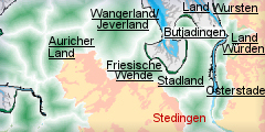
Location
- map: |
Tidal river marsh of
Lower Saxony, Germany |
|
Origin of name: |
May derive from the word
“Gestade“, a reference to the inhabitants of the coastal strip west of
the Weser. |
|
Relationship/similarities with other cultural entities: |
River marshes of
Osterstade, Stadland, Land Würden, peatland areas, mainly pasture
economy, harbour economy, shipping. |
|
Characteristic elements and
ensembles: |
Farm houses, linear
settlements, river marsh, peatlands, pasture, trading. |

2. Geology and geography
2.1 General
Stedingen or the Stedingerland lies in the southern part of today’s district
of Wesermarsch between Brake in the north and Schönemoor in the south; the
Weser forms the eastern boundary and the Geest of Oldenburg the western. The
region is divided by the Hunte into the northern Niederstedingen and the
southern Oberstedingen. The territory of the historic landscape of Stedingen
used to be bigger than today and comprised areas east of the Weser (Osterstade).
The natural spatial arrangement of the landscape is characterised by very
fertile river marshes, especially of the Weser and Hunte, as well as by the
mostly cultivated fens and raised bogs towards the Geest border. One of the
most widespread fens of Stedingen is the Moorriem which reaches a thickness
of several metres. The higher reaches of the Stedingerlands lie roughly at
sea level. Only near Pfahlhausen in the south does the Geest rises above the
Weser marsh. It is typical of landscapes which originated during the
post-glacial period, in that it has a structure of raised river banks and
lower Sietland, the names of Leuchterseite and Brokseite are also used for
this area.
The origin of the name Stedingen is unclear, it possibly derives from the
word “Gestade“ and thus refers to the inhabitants of the coastal strip west
of the Weser.
2.2 Present landscape
The present Stedingerland lies between the Ochtum, Weser and Hunte, several
small rivers like the Berne, Hörspe and Ollen run through it and on two
sides it is enclosed by the Geest. It comprises the present communities of
Berne and Lemwerder. Since the historic landscape of Stedingen used to be
bigger, the communities of Brake (Unterweser), Elsfleth and Ovelgönne also
have to be taken into account.
Along the dyked river Weser small and medium-sized settlements have
developed. Lemwerder and Elsfleth on the Hunte mouth and Brake possess port
facilities which influence the life, culture and economy of the region.
Brake as a Middle Order Centre, with more than 16000 inhabitants is the
county town of the district of Wesermarsch, and the seat of many government
agencies. Communities like Berne or Ovelgönne have a much lower population
density. The communities’ territories, which consist mostly of marsh land,
are used mainly as pasture. The community of Ovelgönne in the north of
Stedingen has managed to preserve its historic character and is almost
completely free of industry. Typical of its landscape are the pastures
crossed by drainage ditches, these are a characteristic feature of the
Wesermarsch as well as cultivated fen areas. Remnant peatlands, like that in
Rüdershausen, have been preserved in parts. The land is characterised by
long narrow field strips and linear settlements.
3. Landscape and settlement history
3.1 Prehistoric and Medieval Times
The large-scale investigation of the North Sea tidal flats is well advanced,
thanks to the efforts made by the Institute for Historic Coastal Research
and by communal, district and county archaeologists. As a comparatively
young geological landscape the Elbe-Weser and Weser-Ems regions are
characterised by quaternary deposits.
There is only indirect archaeological evidence for the introduction of
cultivation methodologies to the Stedingen. However, considering the wider
archaeological context, it can be assumed that Stedingen was part of more
widespread prehistoric and early historic developments. At the beginning of
the post glacial period today’s North Sea coast was still dry land and the
coast itself lay near the present Dogger Bank, it can be surmised that the
river marshes were frequented by Mesolithic hunters and gatherers.
The oldest archaeological finds to date were dredged out of the Weser. They
largely consist of animal bones but antler picks which date to the Middle
Stone Age (Mesolithic) are also represented.
Two stone tools, which were also dredged from the Weser between Elsfleth and
Brake, date to the earliest Late Stone Age (Neolithic). They are associated
with the so-called Linear Band Culture and indicate cultural contacts to
this early foreign farming culture.
Various artefacts from later periods have been found along the western bank
of the Weser or in the Weser itself. They include flint and other stone axes
from the earliest farming culture of North Germany, the Funnel Beaker
Culture, and a flint dagger from the late Neolithic. Important finds in this
context are the objects from the Funnel Beaker Culture from the shores of
the Hunte at the Gellener dyke near Moorriem in the parish of Elsfleth. Here
pottery and flint tools have been found during earthworks with an excavator
at a depth of 0.5 m below sea level on a sandy hill below the clay. They are
interpreted as settlement remains. Unfortunately this site was completely
destroyed. However, there might be further sites from this period along the
Hunte, which could be revealed during construction works. In that case
modern excavation techniques might provide important information about the
early settlement in the river marsh areas.
From the Bronze Age there is a sword found in the Blömer, a side branch of
the Weser near Elsfleth. Near Lemwerder a bronze chisel and dagger were
retrieved from the Weser. A burial site at Berne dates back to the Middle
Bronze Age. Pottery, a bronze kettle and a needle were found deep below clay
deposits. The first intensive colonisation of the river marsh can only be
proven for the late Bronze Age. Urn finds from the urban area of Braker, as
well as pottery sherds from Huntebrück-Wührden and below the Aegidius church
in Berne suggest this. The ground-level settlement Huntebrück-Wührden,
community of Elsfleth, apparently continued to exist until the centuries
immediately after Christ. Even though the Weser marsh can be seen as an area
unfavourable to settlement with its wide bogs which separate the river marsh
from the Geest areas of the Ammerland or Oldenburg, there is, apart from the
rivers, other evidence for inter-communication across this space. A
boardwalk, dated to the 8th century BC by dendrochronology, lead from
Eckfleth, town of Elsfleth, over the bog of Ipwege towards the west. From
the south two other boardwalks, dating from the third to second centuries
BC, lead over the Wittemoor to Holler moor in a northerly direction. As in
all the North German marsh areas, intensive cultivation of the river marsh
took place around the time of the birth of Christ, this appears to have
ceased in the 5th century AD. Many settlements remained ground-level
settlements, with only a few reconstructed as dwelling mounds. One such
exception is the settlement which has been found beneath the church of Berne.
It was raised into a dwelling mound around the birth of Christ. Another
example is that of the dwelling mound of Hogenkamp south of Elsfleth. Since
1874 finds have been made and small excavations carried out on this site.
The dwelling mound so far dates to the 4th/5th century AD. Some finds of
national importance date to the post-Christian centuries of the Roman Iron
Age. In a peat-bog near Strückhausen, south-west of the town of Brake, 28
silver-beaded bronze brooches were found during peat cutting, together with
the remains of fabric and leather. They date into the second half of the
third century BC and are interpreted as a trader’s or craftsman’s deposit.
Along the Weser some Roman artefacts have been found, usually coins or
pottery from between the 2nd and the 5th centuries AD. In this context some
bones with rune cuttings should be mentioned, these were discovered in 1928
during the Weser excavation near Brake. Around 400 AD a very detailed Roman
ship was engraved by a Teuton into one of these bones. During the 4th/5th
century settlement decline began. There is only a little archaeological
evidence from the now Saxon population, e.g. pottery and the unique find of
a lid with a handle in the shape of a pig from a site near Altenesch.
It was not until the High Middle Ages that large-scale cultivation of the
Stedinger Land take place. A few years ago a sounding on a farm dwelling
mound in Bardewisch, community of Lemwerder, was undertaken. The core
dwelling mound had been erected during High Middle Ages and can be seen as
an example for the land-taking process of that period. When Stedingen fell
to Bishop Adalbert of Bremen in 1063, because of his guardianship of
Heinrich IV, he started to systematically colonise the land with farmers
from the neighbouring Geest as well as with Dutch Frisians who were to turn
the so far rather poor soils into fertile farmland. During this time the
systematic cultivation of the peatbogs began, a process which is
historically well documented. The cultivation process was based on drainage
and the building of dams and dykes. The settlers built their farms in rows
with the fields reaching into the bog in long thin stripes. Settlements
sited along the peatbog border are characteristic of this phases of
cultivation, e.g. like those at Moorriem. Here one of these linear
settlements has preserved over a length of over 15 km. Further settlements
of this kind can be found at Neuenhuntorf, Oldenbrok-Mittelort, Harrierwurp
and Sandfeld. They are typified by raised settlement platforms where the
peat base rises from the surrounding lowered ground level. The investigation
of these places by settlement archaeology is still in its infancy.
The cultivation of the wetland towards the Weser was undertaken in the
mid-12th century by dyking and drainage programs. As in other regions of
North Germany, the landscape is crossed by a dense right-angled network of
drainage ditches.
The medieval history of Stedingen during the 12th and 13th century is
characterised by conflicts between the people of Stedingen and the
authorities, they were even accused of heresy. Therefore the Bishop declared
the resulting wars to be crusades. During the second “crusade” the people of
Stedingen suffered complete defeat in 1234 at Altenesch. The victors split
up the land. The largest parts fell to the Archbishop of Bremen and the
Counts of Oldenburg. But they usually left the land to farmed by the
defeated or new colonists on terms of free tenancy (Meierrecht). At the site
of the battle a monument was erected in 1834 (Stedingsehre).
One of the most notable buildings of Stedingen is the St. Ägidius church in
Berne, which is also called “Stedinger Dom“. It was built towards the end of
the 12th century on an already existing dwelling mound. The first building
was erected of imported Porta sandstone from the Weser mountain range. The
rather plain church building was re-built into a three-aisled church of
Westphalian style after the Stedinger wars. After the conquest of the
Stedingerland the Counts of Oldenburg built a burgh, or a “Motte“, next to
the church, which was under the authority of the Archbishop of Bremen. It is
first mentioned in a document from 1242. Other early church buildings are
those of Bardewisch with its late-gothic frescoes, Altenesch, Warfleth,
Neuenhuntorf, Elsfleth, Bardenfleth or Strückhausen.
3.2 Early Modern Times
The late Middle Ages and early Modern Times were the time of Oldenburg
sovereignty of the area. After the death of Graf Anton Günther in 1667 the
King of Denmark was the owner of the County of Oldenburg-Delmenhorst till
1773 and therefore of Stedingen as well. His reign was marked by the
financial exploitation of the region, which caused the dykes to fall into
neglect. The Christmas flood of 1717 was disastrous for the whole
Wesermarsch. In Stedingen, however, the flood damages were remedied within
one year. In the 19th century the Grand Duchy of Oldenburg initialised an
administrative reorganisation and the establishment of new administrative
bodies. Consequently, the Wesermarsch experienced an economic upturn. The
harbour of Brake flourished prior to the foundation of Bremerhaven and it
developed so well that Brake received its own town charter in 1879. Elsfleth
with its port and dockyards was of even greater importance. Berne and
Ovelgönne preserved their rural structures. New administrative structures in
1879, 1933 and 1948 caused repeated changes until in the 1970s the present
community structure was introduced.
3.3 Modern Times
The medieval historic landscape of Stedingen today comprises the communities
of Lemwerder, Berne, Elsfleth, Brake and Ovelgönne. From an economic and
historic point of view certain principles in the settlement processes can be
seen. First there is the marked difference between the more densely settled
area along the Weser banks and the sparsely populated Siet and peat lands.
The development of towns and villages along the Weser led to a concentration
of the population in these areas.
The dykes, both old and modern, are important as a location for settlement,
along their courses linear settlements developed. Then there are the fen
settlements which follow the original course of the fen borders and fen
roads. The communities of Lemwerder and Berne serve as examples for this
type of settlement. The Ochtum-Weser dyke stretches all the way to the Hunte
mouth and has an almost unbroken line of settlements with sporadic
conglomerations along it. Near Altenesch the Ollen branches off, accompanied
by an ancient dike line, along which settlements concentrate. To the
south-west of Berne a road with an irregular course runs along the edge of
the fen with only sporadic settlements of small dwelling places. There are
no settlement alignments on either side of the Hunte dykes since the Hunte
never played any significant role in encouraging settlement.
Between those lines of settlements there are wide empty grassland plains.
Only in the centres of the fens are there scattered villages with single
farmsteads and Kötereien (cottages). In the fieldscape a difference can be
seen between the irregular block-shaped fields on the shore banks and the
long narrow field strips characteristic of the fens.
In the community of Berne the marsh soils predominate: towards the south
they change into peat marsh and peat. Accordingly pasture is the main form
of land use, just as in Lemwerder. Nevertheless, the agricultural structures
are disintegrating. The industry in Lemwerder with its dockyards and
aircraft maintenance plant is also regressive and a change is already
noticeable. The community of Ovelgönne consists of peat marsh with a high
proportion of grassland. Here dairy farming is still the most important
economic factor. The town of Elsfleth on the Hunte mouth with the former
community of Morriem is also characterised by a prevailing pasture economy.
The agricultural economy of Morriem comprises 84% dairy farming and only 3%
tillage. The economic situation of the town of Brake has been largely
dominated by its location by the Weser and its harbour.
4. Modern development and planning
The economy of the Stedingerland is traditionally based on animal husbandry.
Only in the Weser ports of Brake and Elsfleth have dockyards and harbour
industry developed; in the region of Lemwerder an aerospace industry has
established. The Federal Office for Civil Engineering and Regional Planning
in its regional planning report of 2005 classes the district Wesermarsh, and
thus Stehdingen, amongst the areas in which the population and employment
development is characterised by stagnation or a slight decline. The demand
for building land and the traffic increase are rated as being rather low. To
push the economic development all communities have provided building sites
for small and medium-sized businesses. There are also areas which have been
defined as building land for private residential buildings.
The population density differs between the rural areas of the Hinterland and
the congested areas along the Weser. The community of Ovelgönne has 46.6
inhabitants per km², Berne has 83.6 and Elsfleth reaches a number of 81.1;
unlike Lemwerder with 197.9. With 423.8 inhabitants per km² the district
town of Brake (Unterweser) shows a very different pattern.
4.1 Land use
The region of Stedingen consists of river marshes, slightly raised river
banks and the Sietland. The most prominent kind of landscape therefore is
the marsh, which is protected from floods by dykes along the Weser banks.
The river Hunte runs right through Stedingen and joins the Weser near
Elsfleth. At the junction the Huntesperrwerk (Hunte barrage) is sited as a
protection against high tides. In the west of Stedingen the Geest begins. At
the road B 211 in Loyermoor there is the so called “Geest-Abbruch” (Geest
drop), with a height difference of 30 meters.
The land use in the communities of Berne, Lemwerder and Ovelgönne is
characterised by a high proportion of grassland. Therefore agriculture,
mainly pasture, and the associated industries represent the principal
economic emphasis of the area. In the community of Elsfleth the fertile
sandy clayey soils of the marsh are also used mainly as grassland. The river
marsh area and the former peatbogs are only sparsely wooded. With only 0.7 %
of woodland the district of Wesermarsch, is almost completely free of woods.
The peat marshes and former peatbog areas of the hinterland show a grassland
use of 84 %, tillage on the other hand is, at 3 %, almost non-existent.
There are about 130 farms with sizes of 30- 50 ha. in the community.
Considering the intensive agricultural use of the land it can be assumed
that the process of increasing farm sizes is going to continue. Currently
the percentage of people employed in agriculture lies below 8 %, dropping to
2 % in the community of Lemwerder, and could decline even further. This
development has to be seen in the context of the agricultural
intensification which is responding to international pressures. The old
landscape and settlement structures on the Stedinger Marsch might still be
visible but radical changes are looming.
Tourism is an economic factor for the communities of Stehdingen which should
be encouraged in the future. For this reason historic agricultural
structures and farm buildings as well as technological structures such as
drainage ditches or typical views of places should preserved.
4.2 Settlement development
The dramatic drop in employment in the dockyards and in aircraft
construction, e.g. in Elsfleth, is causing gradual changes. From being an
industrial community, Elsfleth is becoming a residential area within the
commuter belt of the High Order Centre of Bremen.
The commuting structures of the communities of Stedingen are quite versatile,
depending on the location of the respective business sites. While Lemwerder
is well balanced the communities of Berne and Elsfleth have almost double as
many commuters going out than coming in. Ovelgönne even reaches a ratio of
three times as many commuters going out. Only Brake has more commuters
coming in for work. The commuting indicates the bad employment situation
which can be attributed to the regressive economy of the dockyards and
aircraft industry. In the long run the southern parts of the district are in
danger of turning into mere residential and dormitory areas. This might
cause a loss of identity, based on the loss of economic traditions, and an
uncontrolled settlement of the landscape.
There is no national museum in Stedingen. Brake has the Shipping Museum of
the Weser Ports of Oldenburg, which lies by the water, it was opened in
1960. The extensive collection relates to the local shipping history of the
region. In Ovelgönne the North German Crafts Museum opened in 1981. It gives
an insight into the trade and crafts of the Wesermarsch in the 19th century
by reconstructing old workshops. A small regional museum in Berne presents
the history of the region. Special places of interest in the community of
Lemwerder include churches like those in Bardewisch or in Altenesch with its
Münstermann pulpit. The monument “Stedingsehre“, which was erected in 1834
by the Ochtum dyke, is a reminder of the battle of 1234. An important church
building is the St.-Aegidius church in Berne, with its three-aisled gothic
hall church, and the altar and the pulpit from the workshops of Ludwig
Münstermann.
Recurring large-scale events of great tourist interest are the horse fair in
Ovelgönner and the Kajenfest (quay festival) in Brake.
Stedingen is part of the cycle path “Deutsche Sielroute“ in the district of
Wesermarsch which comprises more than 200 km of cycle paths. A special
feature is the Juliusplate on the Weser shore near Berne.
The tourist trade could be improved by using the beauty of the scenery, the
historic settlement structure and the high recreational value of communities
of Stedingen as a impetus. In addition to bicycle tourism, camper-van
tourism is being encouraged. In Lemwerder a camper-van park was built and
further sites were established at the Weser and the Ochtum. Elsfleth also
has to offer a pleasure-craft port and landing sites. It remains to be seen
in what way the plans of the community of Ovelgönne (town rehabilitation
plans, planning of business parks and building land allocation, the planned
expansion of Oldenbrok-Mittelort as residential area and the creation of a
real village centre in the typical linear settlement) will affect the
overall picture of the landscape.
4.3 Industry and energy
The district town of Brake with its 16.000 inhabitants is one of the
industrial and administrative centres of the district of Wesermarsch. The
industry is dominated by the port of Brake which is the second largest port
of Lower Saxony. More than 12% of the people working in Brake work at the
harbour industries. Besides the harbour services businesses some other large
companies profit by the proximity of the Weser. A fat refinery, the North
German Natural Gas Processing Association and companies like Siemens and
Rehau run plants in Brake. The port serves as reloading point for the
traditional bulk goods like grain, fodder, sulphur and for bulk cargo like
paper and steel. The container harbour is also of great importance. The
industry of Elsfleht is linked to the fluctuating significance of the
harbour. The Elsflether Werft AG once used to be the largest dockyard around
Oldenburg. Today there is a single shipbuilding company, one brandy
distillery, one packaging industrial plant, one signboard factory and a few
shipping companies which, apart from a number of smaller trade businesses
and manufacturers, dominate the economy of the region. In Lemwerder there is
a maintenance centre for large aircrafts as well as an airfield runway.
There are also two shipyards for the construction of special ships. The
subsidiary company of one of the shipyards specialises in the construction
of rotor blades for wind turbines. In the community of Berne there is no
industry worth mentioning. Dairy production is the main economic feature of
Ovelgönne. The main employer is the company Nordmilch, formerly Botterbloom
Milch e.g. in Strückhausen, community of Ovelgönne, with c. 500 employees.
Numerous wind turbines, single plants as well as wind parks, characterise
the landscape of the southern district of Wesermarsch. The community of
Ovelgönne is particularly affected by this with four wind parks near
Ovelgönne and five more in the Oldenbroker field. They certainly don’t
contribute to the beauty of the landscape of the community.
4.4 Infrastructure
In the east Stehdingen is linked to the motorway network with the A 26
Oldenburg-Delmenhorst and in the west with the A 29, towards Wilhelmshaven.
Near Kleinensiel, in the community of Stadland, the Weser tunnel leads to
the right side of the Weser and to the junction of the A 27 Cuxhaven-Bremen.
The main traffic way in the Stedingerland is the federal road 212 which runs
from north to south: it starts off at Nordenham and leads to the community
border of Lemwerder in the south. The federal road 211 from Brake leads to
the High Order Centre of Oldenburg. In Berne the federal road 74, comes from
the area east of the Weser, meets the 212. Other than that, the country
roads provide a network between the settlements of Stedingen. Only Brake can
claim quite a good infrastructure, due to the location right in the middle
between the towns of Bremen, Bremerhaven, Oldenburg and Wilhelmshaven. The
construction of the Weser tunnel improved the connection to the motorway 27
on the other side of the Weser. At present there is the construction of a
new federal road 211 planned which would improve the connection of the
community of Ovelgönne with the harbour of Brake.
The railroad traffic through Stedingen, and the district of Wesermarsch, has
to be called meagre, especially after the shutting down of many lines during
the last decades. The only railroad line in public transport still serviced
on a regular basis is that of Hude – Berne – Elsfleth – Brake – Nordenham.
The location of Stedingen by the navigable Weser, which is deep enough for
ocean-going vessels, provides the region with a favourable infrastructure.
In Brake, Elsfleth and Lemwerder there are harbours which are connected with
the railroad network. Elsfleth, e.g., is linked by the waterways of the
Hunte and the coastal channel respectively the Weser and the Mittellandkanal
with the agglomeration areas of Nordrhein-Westfalen. Apart from the Weser
tunnel there are also ferries: from Lemwerder to Bremen-Vegesack, from
Motzen to Bremen-Blumenthal and from Berne to Bremen-Farge. The ferry from
Brake to Harriersand only transports pedestrians and bicycles.
5. Legal and spatial planning aspects
From a geological-geographic point of view the Stedinger Land can be divided
into two parts: First, the strip along the Weser with the main settlements
and industrial sites of Lemwerder, Elsfleth, Brake and Berne. In the
regional planning program of 1969 the area is addressed as being the main
focus area. Secondly, the regions to the west and south with Ovelgönne and
the areas of peat soils which border the interior Geest. They are seen as
especially poorly structured areas.
In respect to spatial planning the Stedinger communities are subject to the
regional planning program, issued by the federal state of Lower Saxony,
respectively to the landscape framework plans and land use plans of the
communities. Then there is also the regional development concept of Bremen
in cross-county cooperation. The plans of the community should help preserve
the historically grown structure of the Stedinger Land and stem the excesses
in settlement and agriculture.
For the period of 2000 to 2006 the district of Wesermarsch belonged to the
aim-2-area of Lower Saxony of the EU structural politics. Currently
suggestions for the promotion of rural areas for the period between 2007 and
2013 are under discussion. According to this next to agriculture, other
sources of income like tourism, crafts and trade should become further
supporting elements of the economy of the rural area. The district
Wesermarsch has already presented its own concept for the development and
preservation of its cultural landscape in 2001. It suggested the promotion
and realisation of smaller projects in the fields of tourism, regional
products, nature and culture. Since 2004 the Wesermarsch is one of the
partners in the trans-national project of “Monitoring of the Structural
Changes in the Rural Areas of the North Sea Coast“. It deals with questions
like traffic and transport, ecological development and social aspects.
The landscape of Oldenburg is responsible for the advancement of cultural
and historic interests in Stedingen.
6. Vulnerabilities
6.1 Strategic planning
The possible large-scale establishment of industrial and business parks
to enhance the economic situation could have serious effects on the
traditionally grown structures. The planned housing estate extension of
villages or new routings with bypasses, as planned for Oldenbrok-Mittelort,
with the federal road 211, will damage the typical impression of the linear
villages.
6.2 Agriculture
The international competition and the pressure on agriculture caused by
globalisation might result in an adjustment of the agricultural methods of
production to inherent economic necessities. An enlargement of the farm
areas and a simultaneous decrease in the number of farmsteads – the
so-called farm dying – is the necessary consequence as can already be seen
in some communities.
6.3 Tourism
The pressure of modern mass tourism could lead to the redundancy of
authentic historic structures although the promotion of tourism is becoming
a necessity.
6.4 Industry and energy
The many wind parks which have been constructed impact heavily on the
visual cultural heritage of the landscape. The reduction in local employment
and increase in commuting may cause a loss of identity, based on the loss of
economic traditions, an uncontrolled settlement of the landscape and a loss
of traditional structures.
7. Potentials
7.1 Settlement
Despite of modern influence the cultural landscape of Stedingen has so
far managed to preserve its unique character. Dominating features are the
wide marsh and former moor areas in which the settlements stand out clearly
and thus, together with the dykes and dwelling mounds, give a distinctive
face to the landscape. Linear settlements developed along roads and dykes
while long-narrow field strips are characteristic features of the
Hinterland. The marine towns and villages, which are dominated by the
shipping industry, are distinguishing features of the landscape and
settlement structures along the Weser. The preservation of this settlement
and landscape has great potential both for retaining the regions culture and
for the promotion of tourism.
7.2 Agriculture
The exploitation of the historic agricultural production methods and
landscape can be used to promote tourism into the region. As has been
suggested the promotion and realisation of smaller projects in the fields of
tourism, regional products, nature and culture will improve the image and
economy of the area.
7.3 Tourism
The tourist trade could be improved by using the beauty of the scenery,
the historic settlement structure and the high recreational value of
communities of Stedingen as an impetus. In addition to bicycle tourism,
camper-van tourism is being encouraged.
8. Sources
Author: Frank Both
Först, E. (1991): Zur Besiedlungsgeschichte der Flussmarsch im Kreis
Wesermarsch. Veröffentlichungen der urgeschichtlichen Sammlungen des
Landesmuseums zu Hannover, Bd. 37. Hildesheim 1991.
Hannemann, M. (1954): Der Landkreis Wesermarsch. Die Landkreise in
Niedersachsen Reihe D, Bd. 10. Bremen-Horn 1954.
Krämer, R., Fansa, M. (1991): Bodenfunde aus der Wesermarsch. Archäologische
Mitteilungen aus Nordwestdeutschland, Beiheft 5. Oldenburg 1991.
KomSIS: Kommunales Standort Informationssystem Niedersachsen. www.komsis.de
Meiners, G. (1987): „Stedingen und die Stedinger“. Bremen 1987.
Pätzold, J. (1955): Eine Siedlung der Großsteingrableute unter Normalnull
bei Oldenburg (Oldb.). Oldenburger Jahrbuch 55, Teil II, 1955, 83-97.
Pieper, P. (1989): Die Weserrunenknochen. Neue Untersuchungen zur
Problematik: Original oder Fälschung. Archäologische Mitteilungen aus
Nordwestdeutschland, Beiheft 2. Oldenburg 1989.
Raumordungskonzept für das niedersächsische Küstenmeer. Herausgegeben vom
Niedersächsisches Ministerium für den ländlichen Raum, Ernährung,
Landwirtschaft und Verbraucherschutz - Regierungsvertretung Oldenburg -
Landesentwicklung, Raumordnung. Stand 2005.
Runge, W. (1983): Kirchen im Oldenburger Land, Bd. I. Oldenburg 1983.
Schneider, J. (2001): Mittelalterliche Siedler auf dem Rand des Hochmoores.
Archäologie in Niedersachsen 4, 2001, 97-99.
Seedorf, H.H., Meyer, H.H. (1992): Landeskunde Niedersachsen, Bd. I,
Historische Grundlagen und naturräumliche Ausstattung. Neumünster 1992.
Seedorf, H.H., Meyer, H.H. (1996): Landeskunde Niedersachsen, Bd. II,
Niedersachsen als Wirtschafts- und Kulturraum. Neumünster 1996.
Steinmetz, W.-D. (1989): Archäologische Untersuchungen zur
Siedlungsgeschichte der Oldenburgischen Moorrandreihensiedlungen. Probleme
der Küstenforschung im südlichen Nordseegebiet 17, 1989, 125-165.
Woebcken, C. (1933): Die Schlacht bei Altenesch am 27. Mai 1234 und ihre
Vorgeschichte. Oldenburger Jahrbuch 37, 1933, 5-35.
|