|
1. Overview
|
Name: |
Wangerland-Jeverland |
|
Delimitation: |
North Sea, in the west
the Harlebucht (Harlingerland) and furtheron the border to the
district of Wittmund, in the east the Außenjade respectively the town
of Wilhelmshaven, the southern boundary is rather uncertain and lies
somewhere in the northern part of the Maadebucht |
|
Size: |
Approx. 285
km² |
|
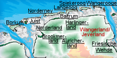
Location
- map: |
Marsh landscape in the
northern part of the district of Friesland with the communities
Wangerland, Jever, Schortens as well as in the eastern part of the
community Sande, Lower Saxony, Germany. |
|
Origin of name: |
From ‘wanga’ , meaning grassland or plain. |
|
Relationship/similarities with other cultural entities: |
Comparable both for its
cultural and heritage landscape to Harlingerland and Auricherland and
other cultural entities around the Jade and Weser. Shares the East
Frisian “ Gulf House” style. |
|
Characteristic elements and
ensembles: |
East-Frisian “Gulf-house“,
dwelling mounds landscape, church and village dwelling mounds,
settlements following the course of dykes, sluice harbours, irregular
blocks of land of the Altmarsch (old marsh) region, organised strip
fields of the Grodenmarsch region. |

2. Geology and geography
2.1 General
The cultural entity of Wangerland/Jeverland is in the northern part of the
present district of Friesland. Wangerland forms the northern part of the
Jeverland and is a historical name which dates back to the Frisian area
wanga, meaning grassland or plain. The islands along the coast, the dune
island of Wangerooge, as well as the unsettled flat sand plates of Minsener
Oog and Oldeoog, are also part of the district area.
The Jeverland dates back to the historic territory of of Jever which
developed in the 14th century and combined the Wangerland, great parts of
Östringen, as well as the Banter Viertel in the north-western part of
Rüstringen. A precise definition of the boundaries of the Jeverland is
rather difficult, due to changing political power structures and border
conflicts as well as natural disasters which caused various territorial
changes. Examples for these processes include the development of the
small-scale immediate lordships of Inhausen and Kniphausen in the present
area of the town of Wilhelmshaven towards the end of the 15th century, and
the sea incursions in the medieval period of the Harlebucht and the
Jadebusen.
To the north the Wangerland and Jeverland are bordered by the sea while the
Außenjade and the Jadebusen form the eastern border. The southernmost
districts reach almost to Sande. The western border originates in the 15th
century separation of Ostfriesland and Jeverland (Oldenburg). This border
remains such a strong institution in the minds of the people, that in 1977
the merging of the districts Wittmund and Friesland had to be reversed.
The Wangerland and Jeverland largely comprises a completely flat marsh
landscape. Only in the south-western part of the Jeverland does part of the
East Frisian-Oldenburger Geest, together with its towns of Jever and
Schortens, reach far into the marshes. Along the Geest ridge there are many
border fens, known as the Sietland. The marsh landscape can be divided into
an old and a young marsh which differ clearly in their genesis and formation.
The old marsh came into existence during the post-glacial sea-level changes
in prehistoric times and has been settled since then. The young marshes on
the other hand are the results of land reclamation schemes following
medieval land loss to rising sea-levels. The younger marshes are mainly in
the Crildumer Bucht area, west of the Jadebusen and in the Maadebucht. Most
of today’s coast line was in place by the end of the 19th century. The
composition of the marshland soils echoes their origins. The old marshes
comprise densely bedded, waterlogged, clay soils which support ‘classic’
grassland habitats, whilst the younger and sandier sea marshes make quite
good arable land. The coast comprises tidal flats, dune islands and sand
flats, these form part of the national park of Niedersächsisches Wattenmeer.
2.2 Present landscape
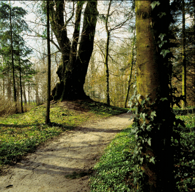
There is a stark contrast between the Jever Geest with its fens, birch trees,
bank hedges and tree-lined roads and the wide-open sparsely-wooded marsh
landscape. The old marsh strip in the north-east of the cultural entity
covers an area up to 10 km wide and c. 15 km long. The shape and outline of
this region can still be clearly distinguished in today’s landscape at the
Jadebusen, even after the re-dyking of the Harlebucht and the Crildumer
Bucht. A very distinctive feature is the course of the road along the well
preserved and slightly raised 14th century dike line which encloses the old
marsh region. Its origin is well documented by place names such as Tettenser,
Medenser, Wiarder or Wüppelser Altendeich (old dyke).
The contrasting history of the marsh areas is also reflected in the
different land use and settlement structures which characterise the
landscapes of the Jeverland. In the old marshes the fieldscape comprises
small-scale irregular plots, in contrast to the regular large-scale blocks
of land of the Grodenmarssch regions at the Jadebusen and in the Maadebucht.
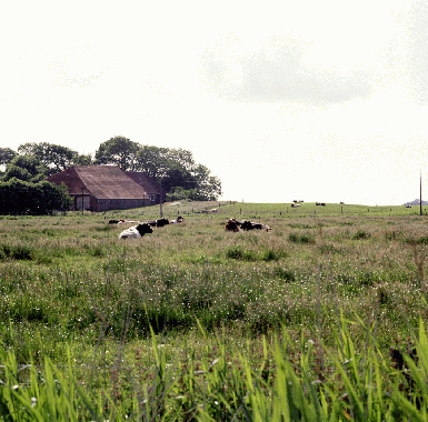
The old marsh is also characterised by dwelling-mounds (warf or terpen) with
their buildings and trees. The Grodenmarsch regions are characterised by
settlements aligned along the dyke lines. The buildings in both areas are
characterised by impressive farm houses of the ‘Gulf’-house type.
3. Landscape and settlement history
The Wangerland/Jeverland has a complex settlement history, and the marsh
landscape in particular reflects man’s continual struggle to reclaim and
retain land from the sea, as evidenced by the characteristic dykes and
dwelling mounds.
3.1 Prehistoric and Medieval Times
Large scale study of the North German mud flats and the adjacent Geest have
successfully progressed, due to the efforts of the Institute of Historical
Coastal Research and municipal, regional and local archaeologists. As a
geologically recent area the Weser-Ems area is marked by quarternary
deposits. The tidal river marshes of the Jeverland/Wangerland have developed
since the end of the last Ice Age.
The exact date of the first settlement in the Jeverland/Wangerland is based
on comparison with neighbouring areas. At the beginning of the post-Ice Age,
today’s southern North Sea coast was dry land and the North Sea coast was
located in the area of the Dogger Bank. It is presumed that the Jeverland/Wangerland’s
tidal river-marshes were frequented during the Palaeolithic and Mesolithic
period by hunter-gatherers. It is also possible that sites relating to this
period of occupation are located beneath the marsh-soils and their millennia
of sedimentary deposits.
The Geest has probably been permanently settled since the Neolithic, c.
4.000 BC, by farmers. However, the exact extent of this settlement is still
unknown. The oldest surviving archaeological monuments are sited near
Schortens: cemeteries consisting of burial mound cemeteries which have been
in use since c. 2000 BC.
The standard of knowledge about the early settlement of the marsh is also
fragmentary. There are sporadic settlement sites from the time around the
birth of Christ. In the beginning the marsh settlements were built on flat
ground. With the subsequent rise in sea level during the first century BC,
the building of dwelling mounds began. These were formed by the heaping up
of dung and clay to raise the settlement site above the surrounding marsh.
There were several hundred dwelling mounds with villages, churches and
single farmsteads scattered across the Jeverland, mainly erected during
medieval and early modern times.
The increasing threat of continually rising storm tides forced the marsh
population to build their villages on large joint dwelling mounds. The
location of these settlements can still be seen in the rows of dwelling
mounds in the old marsh. Like beads on a string, the mounds are aligned
along the oldest areas of firm marsh land in the Wangerland and thus mark
the fringes of the oldest settlement areas in this region. The village
dwelling mound Ziallerns in the district of Tettens is unique. It probably
is the best preserved and most self-contained unit of its kind in the
Jeverland. Ziallerns lies in the old marsh on a system of priels (drainage
channels) which probably once linked the Harlebucht and the Jadebusen.
Boreholes have shown that the dwelling mound was erected over a ground-level
settlement dating to the Roman Iron Age. The nearly circular construction,
with a radial inner structure, is 200 m wide and almost 5 m high, and rising
clear above the surrounding land. The mound is enclosed by a circular path
from which other agricultural roads radiate like a spider’s web into the
landscape. Other impressive examples of villages on dwelling mounds are the
Langwurten (long dwelling mounds) of Neuwarfen and Wüppels.
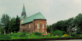
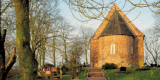
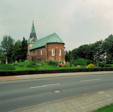
After the Conversion of the Frisians to Christianity in the 10th century,
people began to build more and more churches. Since the mid 12th century
wooden churches were replaced by massive granite stone churches. Churches
were either built on separate mounds erected near the village dwelling mound,
or in the centre of existing high village dwelling mounds. Many churches in
the Geest, like that in Jever, are also sited on artificial earth mounds to
make them more prominent in the landscape. In the Wangerland and Jeverland
there is a unique concentration of Romanesque granite block churches,
forming a very characteristic features of the landscape. The reasons for the
building of such an unusual number of impressive churches in an agricultural
setting within a short period of time during the 13th century are still
largely unknown.
 |
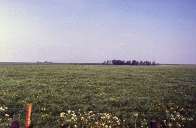
 |
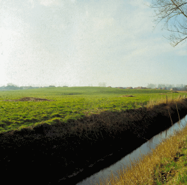
| Historic landscape with dwelling mound nearby
Minsen |
Historic landscape with
dyke nearby Hohenkirchen |
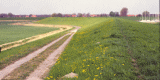
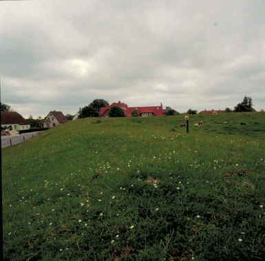
The construction of dykes began in the 11th century. The first ones were
circular dykes which protected the fields and meadows of a village rather
than the settlement itself. Later these systems were gradually extended,
until they linked up to form the so-called Altdeich (old dyke) which
enclosed the whole Wangerland. The old dwelling mounds were not however
abandoned. Even though they were not strictly necessary anymore because of
the safety provided by the dykes, they still protected the settlements from
the soddenness of the ground during the winter months. Gradually the
dwelling mounds merged to form villages, and the medieval settlement of the
newly gained agricultural areas proceeded. Unlike the other marsh regions of
the North Sea coast, the dwelling mound landscape of the old marsh of the
Jeverland largely comprises widely scattered settlements. In the new marsh
Deichreihensiedlungen (linear settlements along dykes) developed, as
demonstrated to the north of the Maadebucht and south of Wilhelmshaven.
 |
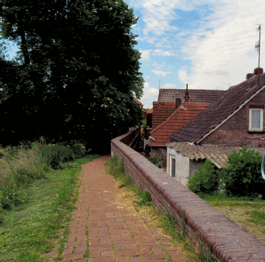 |
| Historic landscape with drainage ditch and
relics of a castle |
Historic settlement
landscape with dyke at Pakens |
3.2 Early Modern Times
The settlement of the new marsh in the Crildumer Bucht began in medieval and
early modern times. The principal settlement of the Wangerland since the
medieval period was Hohenkirchen. The history of the region is however very
complex. Originally the East Frisian peninsula was divided into two counties,
however this developed into an almost complete independence of the Frisian
countries (“Friesische Freiheit”) in the 12th century. The Frisian country
communities were subject to a cooperative self-administration.
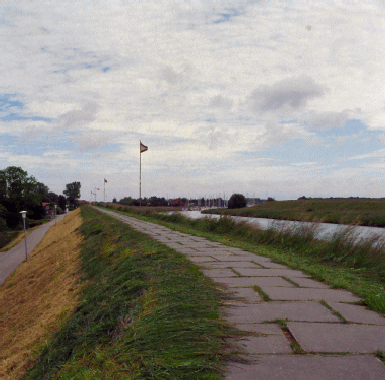 |
 |
| Historic landscape
with dyke nearby Pakens |
After the mid 14th century some members of the farmers’ upper class
developed as local potentates, known as chieftains. As a consequence, the
14th and 15th centuries were marked by power-struggles, with single chiefs
trying to extend their spheres of influence. Competition between the chiefs
included improving the appearance of their dwellings and surroundings and
the construction of castles in the form of tower-like stone houses which
were fortified by banks and ditches. None of these castles have been
preserved in their original layout.
Whilst several small castles from the Renaissance (e.g. Rickelhausen near
Westrum or Canarienhausen near Waddewarden) have completely vanished, there
are some good examples of this type of building, e.g. Groß Scheep near
Wiefels and the particularly impressive Schloss Fischhausen near Wüppels,
the latter underwent modification in 1578. The Sibetsburg used to be one of
the most powerful castles of its time. Here the Rüstringer chiefs ruled
until their downfall in 1433, this led to the rise of the dominion of Jever.
Even though the castle was demolished in 1435 the castle hill as well as the
bailey and the extensive system of banks and ditches can still clearly be
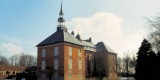
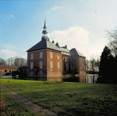
seen in the townscape of Wilhelmshaven. The castle in Jever with its
characteristic onion spire dates back to a defensive work of the 14th
century, whilst today’s representative four-winged structure was built in
the 16th century. In Gödens and Kniphausen, the chiefs’ residences of the
14th century have also been preserved, although they have undergone
widespread modifications, as at the castle of Jever.
 |
 |
| Moated castle of Gödens |
Afforested relics of a
bastion nearby Gödens |
3.3 Modern Times
Agriculture is the traditional economy of the Jeverland. It has
characterised and transformed the landscape, particularly in the last
century. Several periods can be clearly distinguished which have led to
distinctive changes in the land use, or in its intensity, in turn causing
changes to the appearance of the cultural landscape. After the medieval
settlement phases and the land reclamation around 1500 there was an increase
in the agricultural productivity of the Jeverland.
The agricultural economy, which had been largely animal based changed to
tillage after 1650 due to the influence of wider global economics. Strong
population growth and a rising demand for food promoted the trade in grain
as well as meat and dairy products. This led to a temporary domination of
the cultivation of grain in the 18th and 19th centuries which was followed
by a stronger emphasis on dairy production in the old marsh by 1900. A
further change was caused by the beginning of the industrialisation of
agriculture after 1950.
All these phases had different impacts on the cultural landscape of the
Wanger- and Jeverland which still can be seen in today’s landscape. One of
the most characteristic features of this period is the “Gulf”-house. These
impressive dwelling and farm buildings reflect the high productivity of the
agriculture of this time. The acquisition of agricultural land and the
enlargement of the farms resulted in the consolidation of agricultural
enterprises and a lack of reallocation of land (Flurbereinigung) in the
Jeverland. This had a positive affect on the preservation of traditional
field systems. Relicts of a temporary boom of grain production, which should
be definitely preserved within the modern landscape, are the ridge and
furrow-systems (Wölbäcker), now largely relict in meadows.
4. Modern development and planning
Many characteristic features of the cultural landscape of Wangerland and
Jeverland have been preserved until today: including the distinct landscape
of dwelling mounds with its villages and big farmsteads. There have however
also been changes to the landscape since the second half of the 20th century,
which continue until today. The alterations result mainly from the
agri-industrial structural change in agriculture. This has led to an
emphasis on agricultural techniques, ignorance of the natural environment,
and the loss of employment in agriculture. In addition there are new claims
on the land, like tourism which is pushing into the hinterland of the coasts
and wind-power. One of the biggest infra-structure projects of Lower Saxony
is planned in the neighbouring Wilhelmshaven, the Jade-Weser-Port.
4.1 Land use
Wangerland and Jeverland are dominated by an agricultural economy, and
agriculturee is the principal land use in this region and cause of the
cultural landscape. Because of the different soil conditions the
agricultural use varies according to area: the older parts of the marsh,
with their heavy, wet soils, are mainly used as pasture, whilst the younger
parts of the marsh along the coastline and beside the Außenjade are used for
corn growing. There is no increase in the growing of renewable resources
even though there is a new law (Erneuerbare-Energien-Gesetz [EEG]) to
promote the cultivation of those plants. Corn-growing is still economically
productive.
The abolition of the milk quota will pose a problem for the economy of the
older marshes with its high percentage of grassland. There are only very few
possibilities for these farmsteads for independent conditioning. In addition
the payments for not using the meadows as pasturage are not sufficient to
ensure a farmers income. Therefore, a program especially for cattle farmers
of disadvantaged areas is needed. There are for example of the Lower
Saxonian “Agri-Environmental-Program” of the Ministry of Agriculture
promoting pasturage. A complete change to the historic agricultural use of
this area would have devastating consequences for the preservation of the
historical cultural landscape.
The change in agricultural practices, which lead to bigger cattle herds and
a movement to new, larger farmsteads on the outskirts of the villages, have
also affected the characteristic settlement structures. These new farmsteads
with modern stables or chicken-mast-houses dominate the landscape.
Many of the cultural monuments, which were originally used for agriculture,
have lost their function because of this change, and their upkeep is
neglected. Only 30 to 70% of the older farm-buildings are still in use today.
In addition the modernising of the rural infrastructure can cause damage to
single monuments or parts of ensembles. Thus the facades of historical
buildings will be changed by introduction of insulation and the old surfaces
of streets be altered by the addition of tarmac or concrete (this latter
change is particularly pertinent to the important cobble-stone pavements
[Klinkerstraßen] in the Wangerland). The introduction of an energy-pass by
the energy-saving decree (Energiesparverordnung [EnEV]) will have a
particular impact, as houses which do not meet the standards of the decree
will suffer from depreciation and the modernisation of building for the sake
of saving energy will be encouraged.
4.2 Settlement development
There is an increasing need for land for housing, especially around the main
towns of the region like Jever, Schortens, Sande, Hohenkirchen, near the
sluices at the Jadebusen, and particularly around Wilhelmshaven. Prior to
this, some districts of the city of Wilhelmshaven became somewhat abandoned.
This tendency of consumption of land on the Geest, and even more obviously
in the Marshes, leads to a loss of traditional settlement structures and the
region´s unique landscape. Urban development and administrative urban
planning are absolute necessary to control the development, e.g. with
concepts for an increasing inner-urban concentration. These problems will
become even more pressing when it comes to the building of the
Jade-Weser-Port. During the time of construction, between 2007 and 2010, a
large quota of employees will be needed, and who will require housing. It is
possible that there will be other more wide-reaching effects of the
construction of this deep water harbour on the Jeverland, dependent on the
establishment of local logistic services besides the freight trade.
 |
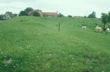
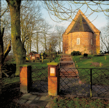 |
| Church on a dwelling mound at Sande |
Church on a dwelling mound
at Wüppels |
Since the middle of the 1950’s the coastal region has developed as an
important recreational area. With 2 million overnight stays per year,
tourism has become one of the most important sources of income in
Wangerland, including the isle of Wangerooge. While the tourist
opportunities in the marsh regions are mostly limited to “Holiday on a
Farm”, there are intensive recreation facilities concentrating around the
sluices along the coast, which occupy large areas of land, e.g. campsites,
resorts etc. There is also a growing tendency to establish these kinds of
structures in the hinterland. A good example is the location in the
neighbourhood of Hohenkirchen, where it is planed to install a new kind of
recreation area with an artificial pond for swimming and a hotel on a former
pit where sand has been removed.
 |
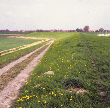
 |
| Historic, open
landscape with dyke nearby Hohenkirchen |
The museum of the castle in Jever and the Institute of Historical Costal
Research (Institut für Historische Küstenforschung) in Wilhelmshaven are two
of the most important institutions for research and education. Their work is
focused on the development of the cultural landscape of the Wangerland and
Jeverland. A small regional museum (Heimatstube) on Ziallerns demonstrates
the development of the dwelling mounds of the Jeverland.
4.3 Industry and energy
Whilst there are only a few industries in Wangerland and Jeverland, the
Groden (what are these ?) are the most important locations for industry in
the region. They were built one by one at the Jadebusen in Wilhelmshaven (Voslapper
Groden, Rüstersieler Groden and Heppenser Groden). These highly visible
industrial structures are now having an effect on the scenery of the
Wangerland.
Wilhelmshaven, with its Oil-Harbour, the tanker discharge bridge and the
NOW-Pipeline, has gained national significance as Germany’s biggest harbour
for crude oil. The NOW-Pipeline runs to the Rhein-Ruhr region and crosses
the south-eastern part of Jeverland.
Wind energy plants have also had a lasting effect on the historical
landscape of Wangerland and Jeverland in recent times. Since 1989 81 single
wind turbines have been erected. The highest increase came from the “Bürger
Windpark” near Bassens. Since the community of Wangerland was designated as
a specific area for the purpose of gaining power by wind energy in its land
utilisation plan (Flächennutzungsplan), the uncontrolled erection of wind
energy plants had been stopped. Now no wind energy plant can be erected
outside these specific areas anymore. In the future “Repowering” will
encourage a reduction in the numbers of single installations and encourage
their concentration on wind farms. Amongst other sites, it is hoped to
remove single worn-out installations on the Hohenstiefersiel for the sake of
the scenery.
4.4 Infrastructure
The problematic layout of the road network in the Wangerland and Jeverland,
the water ways were used for traffic in to recent times. Trading goods were
exported and imported over the sea. Even in the inland areas, the natural
water ways, like the Tettenser Tief or the Hooksieler Tief, were used.
During the most part of the year the clay roads were impassable and goods
could not be transported. In the middle of the 19th century a path, called
the “Wangerweg” which led from Jever to Hohenkirchen, was an important
traffic route. This as an extension of the Frisian Hostway (Friesische
Heerstraße) from Oldenburg to Jever. In Wangerland it belonged to a road
network with its side paths linking up the parishes of the 16th century.
The historical road network has not changed until modern times in the
Wangerland. The waterways are not important anymore but the main streets and
roads follow the original road network which developed during the settlement
of the land during the past centuries and follows the historical dykes.
Nowadays traffic from the south comes in over the A-29. Further on, the
north-west and south-east connection are the main roads 210 towards Wittmund
and B 436 towards Friedeburg as a by-pass. Some years ago the B 210 had been
extended in the region around Jever. It now is a “Kraftfahrtstraße” (clear
way) of a “2 to 1”-system without any crossings. The same is planned for the
area around Schortens. From there on the motorway will have four lanes and
lead to the harbour of Wilhelmshaven. The coastal motorway A-22, which is in
planning, will bring a direct connection to the regions east of the
Jadebusen and Hamburg.
The formerly well developed railway system in Wangerland and Jeverland was
reduced since the second half of the 20th century. There is no direct
connection to the coastal regions by train anymore. Since 2000 a private
railroad company (Nord-West-Bahn GmbH) runs the lines in the area of
Oldenburg-Wilhelmshaven-Jever-Wittmund. This has grown to be an attractive
transport system for the region. During the construction of the
Jade-Weser-Port it will be necessary to think carefully about a by-pass of
Sande.
5. Legal and spatial planning aspects
The Wangerland and Jeverland belong to the rural district of
Friesland. The northern part has the communities of Wangerland and
Schortens, the western part the community Sande and the city of Jever. The
north-western part of the county borough of Wilhelmshaven, which is its
eastern neighbour, belongs to the Jeverland.
The regional program for spatial planning (Regionaler Raumordnungsplan [RROP])
from the 10th of September 2004 for the rural district Friesland,
strengthens the more general aims of the Lower Saxonian state office spatial
planning of the Wangerland and Jeverland and fixes the regional aims for its
development. An individual contribution from the Office for Natural
Protection is the landscape framework plan (Landschaftsrahmenplan) of the
rural district of Friesland. It is the basis for the protection of
historical cultural landscapes or parts of historical cultural landscapes of
specific characteristics as well as special important historical elements of
cultural landscapes like cultural, building or ancient monuments. The advice
of the land utilisation plan of the communities will also have to be taken
into account.
Another important basis for enduring and sustainable spatial planning in
Jeverland is the innovative ideas of the inter-municipal co-operation of the
districts of Friesland, Wittmund and the city of Wilhelmshaven. They took
part at the program “Modellvorhaben der Raumordnung (MORO)” (pattern of
tasks of spatial planning) of the Ferderal Office of Traffic, Building and
Urban Development (BMVBS) as well as the “Flächenagentur Region – Friesland
– Wittmund – Wilhelmshaven” (Agency for space of the region Friesland –
Wittmund – Wilhelmshaven) which was founded in 2003.
Because of its historic origins in the district of Oldenburg, the rural
district of Fiesland, including the Jeverland, belongs to the
“Oldenburgische Landschaft”, whose duty it is to take care of the historical
and cultural interests.
6. Vulnerabilities
6.1 Strategic Planning
Strategic planning for large scale developments especially within
Jeverland needs to consider the existing cultural heritage both in the form
of surviving landscape as well as the buried archaeological deposits.
6.2 Settlement
The historic settlement pattern is important within this area and is
vulnerable to the threat from development within the core and expansion
around the perimeter. The historic farmsteads are also vulnerable to change
of use away from traditional agricultural production.
6.3 Agriculture
Globalisation and competition with wealthy regions within Germany has
led to more intensive agricultural production and an enlargement of
farmsteads. Wide areas of the Jeverland, especially the older Mashes, are
limited by its natural conditions and it is very difficult to intensify
agricultural production. There is the possibility that the area could lose
its economic attraction for agriculture, and there is the potential that
farming will be abandoned on a large scale. Both these scenerios would
result in the cultural landscape of the Jeverland being vulnerable to change.
6.4 Tourism
Tourism in the Wangerland depends at least in some parts more or less
directly on reconsilable agriculture. If the agricultural basis is abandoned
the landscape and structures within it will decline. On the other hand
tourist use should not lead to the installation of large scale
infrastructure without any reference to the natural and historic cultural
landscape.
6.5 Industry and energy
Wind turbines and wind farms can have an adverse effect on both the
visual historic landscape as well as the buried cultural heritage. The
qualities of parts of this landscape are its openness and its quietness and
these are at threat from continuing expansion of wind energy. The
construction of more concentrated wind farms needs to consider both the
visual landscape and the potential buried archaeological deposits.
7. Potentials
7.1 Spatial Planning
It is essential for the preservation of the historical cultural
landscape of the Jeverland that projects of communal co-operation in spatial
planning include the cultural heritage as an integrated element. For the
preservation of the cultural landscape a consistent and inter-disciplinary
co-operation between the Office for Natural Preservation and the Bureau for
Conservation of Historic Monuments will have many positive effects.
7.2 Settlement
The historic settlement pattern is important within this area and has
potential for being a resource to encourage tourism. Careful integration of
the cultural heritage into planning proposals provides the potential both
for the preservation and management of the historic settlements. The
historic farmsteads have the potential to promote local agricultural
production as well as to be carefully used as tourist accomodation.
7.3 Agriculture
Agriculture has been the main historic economy for this area and remains
so. The area has not suffered as badly as other areas through
intensification and many of the historic monuments associated with
agriculture survive within the landscape. These have great potential to be
promoted, protected and managed via tourism and protection via agricultural
schemes. These features tell an important story for the development of this
area and their value should be identified both to the local population and
the incoming tourists.
7.4 Tourism
The high density of historic monuments and the good quality of the
surviving historic landscape means that this area has a high potential for
increasing its tourist value. The museum Jever and the Institute of
Historical Costal Research in Wilhelmshaven have the potential to be the
focal points for the development of cultural tourism in the area.
8. Sources
Author: Ortrun Schwarzer
Blischke, H. (1997): Die Marsch des südwestlichen Jadegebietes. – Geschichte
– Gegenwart – Zu-kunft -. Unveröffentl. Projektarbeit am Inst. f.
Landschaftspflege und Naturschutz der Universität Hannover. Hannover.
Coldewey, H., Murken, T., Reinhardt, W. & Schrade, W. (1986):
Wilhelmshavener Heimatlexikon 1. Wilhelmshaven.
Coldewey, H., Murken, T., Reinhardt, W. & Schrade, W. (1987a):
Wilhelmshavener Heimatlexikon 2. Wilhelmshaven.
Coldewey, H., Murken, T., Reinhardt, W. & Schrade, W. (1987b):
Wilhelmshavener Heimatlexikon 3. Wilhelmshaven.
Ellenberg, H. (1990): Bauernhaus und Landschaft in ökologischer und
historischer Sicht. Stuttgart.
Entera (2006): Umweltbericht der Strategischen Umweltprüfung zum
Niedersächsischen und Bremischen Programm für die Förderung der Entwicklung
des ländlichen Raumes 2007-2013. Gutachten im Auftrag des Niedersächsischen
Ministeriums f. d. ländlichen Raum, Ernährung, Landwirtschaft und
Verbraucherschutz. Hannover.
Ey, J. (2000): Der frühe Deich- und Sielbau. Archäologische Denkmäler
zwischen Weser und Ems. Oldenburger Forschungen N. F. 13, 171–181.
Haiduck, H. (1997): Mittelalterlicher Kirchenbau in Friesland. In: A.
Sander-Berke (Hrsg.), Fromme Friesen. Mittelalterliche Kirchengeschichte
Frieslands. Oldenburg, 51–80.
Jürgens, A. (1982): Hohenkirchen ein Marschendorf im Wandel der Zeit. Jever.
LANCEWAD (2001): Landscape and Cultural Heritage in the Wadden Sea Region –
Project Report. In: Common Wadden Sea Secretariat (Hrsg.), Wadden Sea
Ecosystem. Wilhelmshaven.
LRP LK FRI – LANDKREIS FRIESLAND (1996): Landschaftsrahmenplan Landkreis
Friesland. Planungsgruppe Grün. Bremen, Jever.
Luft, H. (1998): Fremdenverkehr im Wangerland. Fremdenverkehrsstruktur und –entwicklung
der Gemeinde Wangerland. Wilhelmshavener Schriftenreihe Tourismuswirtschaft
4. Limburgerhof.
Neidhardt, H. (1980): Baudenkmäler im Oldenburger Land. In: Oldenburgische
Landschaft (Hrsg.), Führer zu Boden-, Bau- und Siedlungsdenkmälern.
Oldenburg.
Nitz, H.-J. & Jachens, U. 1993: Historische Geographie des mittelalterlichen
Deichbaus. Abschlussbericht des Forschungsprojekts. Unveröffentl.
Manuskript. 83 S., Geograph. Inst. d. Univ. Göttingen.
Niedersächsisches Institut für Wirtschaftsforschung (NIW; 2005):
Regionalbericht Norddeutschland 2005. Hannover.
Reinhardt, W. (1969): Die Orts- und Flurformen Ostfrieslands in ihrer
siedlungsgeschichtlichen Ent-wicklung. – In: J. Ohling (Hrsg.), Ostfriesland
im Schutze des Deiches 1. Pewsum, 201–375.
Rüther, W. (2000): Gulfhaus-Verzeichnis. In: Ostfriesische Landschaft &
Niedersächsisches Landesamt für Denkmalpflege (Hrsg.), Gulfhäuser in
Ostfriesland. Kartgraph. Darstellung. Norden.
Salomon, A. (1986): Historisch-Landeskundliche Exkursionskarte von
Niedersachsen, Teil 10. Blatt Wangerland, Hooksiel-West. 1:50 000.
Erläuterungsheft. Veröffentlichung des Instituts für Historische
Landesforschung der Universität Göttingen. Hildesheim.
Schenk, W. (1963): Die Verkehrswege im Landkreis. In: Landkreis Friesland
(Hrsg.): Der Landkreis Friesland. Geschichte, Kultur, Landschaft,
Wirtschaft. Oldenburg, 19–22.
Schwahn, C. (1997): Kriterienbildung einer ästhetischen Bewertung von
Marschenlandschaften. In: L. Fischer (Hrsg.), Kulturlandschaft
Nordseemarschen. Hever, 189–200.
Schwarzer, O. (2002): Landschaftliche Eigenart im Wangerland/Friesland –
Grundlagenermittlung für die Landschaftsrahmenplanung. Unveröffentl.
Diplomarbeit am Inst. f. Landschaftspflege und Naturschutz der Universität
Hannover. Hannover.
Seedorf, H. & Meyer, H.-H. (1996): Landeskunde Niedersachsen 2. Natur- und
Kulturgeschichte eines Landes. Niedersachsen als Wirtschafts- und
Kulturraum. Neumünster.
Siemens, M. (1989): Getreidebau im Jeverland. Historische Grundlagen und
technologische Entwicklung. In: U. Meiners (Hrsg.), Museums-Materialien des
Schlossmuseums Jever 2. Jever.
Strahl, E. (2000): Ländliches Siedlungswesen im frühen und hohen Mittelalter
(ca. 600 – 1200). In: Archäologische Denkmäler zwischen Weser und Ems.
Oldenburger Forschungen N. F. 13, 108–121.
Streif, H. (1990): Das ostfriesische Küstengebiet. Nordsee, Inseln, Watten
und Marschen. Sammlung Geologischer Führer 57. Berlin.
Thieme, H. (1997): Älteres Paläolithikum aus dem Gebiet zwischen Weser und
Elbe. In: L. Fiedler (Hrsg.), Archäologie der ältesten Kultur in
Deutschland. Materialien zur Vor- und Frühgeschichte von Hessen 18, 328–356.
Wulf, F.-W. (1986): Zur Inventarisation archäologischer Baudenkmale im
Landkreis Friesland. Oldenburger Jahrbuch 86, 267–289.
|