|
1. Overview
|
Name: |
Wangerooge |
|
Delimitation: |
The island of Wangerooge is situated in the
Wadden Sea of Lower Saxony. The administrative border lies at the line
of the average high tide (MThw). |
|
Size: |
Approx. 4.97 km² (administrative district
of Friesland) |
|
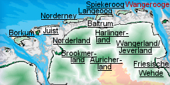
Location
- map: |
The most easterly of the seven islands in
the Wadden Sea area of Lower Saxony. Its nearest neighbour is
Spiekeroog. |
|
Origin of name: |
The syllable „Oog“ can be translated as
island. |
|
Relationship/similarities with other cultural entities: |
Frisian Islands, Islands of Lower Saxony,
dune landscape, maritime landscapes and settlements. |
|
Characteristic elements and
ensembles: |
Barrier island, dune landscape, tree groves,
Friesian building-types (Suderloog). |

2. Geology and geography
2.1 General
Wangerooge is one of seven East Frisian Islands off the coast of Lower
Saxony and is sited in the c. 2780 km² large national park Niedersächsisches
Wattenmeer.
The island has a length of 8 km from west to east and a maximum width of
about 1.4km.
Wangerooge is one of the barrier islands and has developed in the course of
the interaction of wave energy and tidal range. Barrier islands originate
from periodically flooded sand plates and develop first into flood-free
beach banks and then into dune-covered islands. An important part of this
process is the blowing of sand from the wet beach which initiates dune
formation. The natural tendency is for the island to move in an easterly
direction, with the loss of land at the western end and the deposition of
sand at the eastern end. Thus much, and maybe all, of the earliest
settlement has been lost.
2.2 Present landscape
At present, Wangerooge, is a dune-covered island affected by the steady
interaction of low and high tide. To the south of the island are the
mudflats of Lower Saxony. The islands are separated by deep tidal inlets,
known as the Seegats.
The continuing destruction of the western part of the island shows that
Wangerooge is still subject to constant change. The reason for this is the
west-east sand drift which is induced by the interaction of the tidal
currents on the one hand and the prevailing westerly winds on the other
hand. The currents cause sand erosion in the west and sedimentary deposition
to the east. In addition the sand reefs on the eastern Tipp of Spiekeroog
break loose, and then move in an arc (Riffbogen) to the neighbouring island
of Wangerooge to the east and deposit their sands in the middle or the east
of that island. Efforts are being made on Spiekeroog to slow down this
morphological process.
There are some trees on the island, chiefly within the settlement areas.
Dunes, dune valleys and salt meadows are characteristic natural landscape
elements of every East Frisian North Sea Island. The western and eastern
ends of Wangerooge is covered by dune complexes and salt meadows, and the
vast beach on the eastern end of the island; the settlement is located in
the area between them the settlement is located.
3. Landscape and settlement history
3.1 Prehistoric and Medieval Times
In the course of the post-glacial period and the melting of the ice sheet,
the North Sea reached the present-day coastal line by c. 5500 B.C. The
transgressive North Sea, under the influence of waves and tides pushed a
seam of sand in front of it, which progressively increased in size. This
barrier zone of sand supplied the material for the sand plates which largely
evolved in the slipstream of Geest cores and later developed into true
barrier islands, the predecessors of today’s dune islands. On the former
beach bank systems and higher sand plates Wangerooge developed, as one of
the barrier islands which align like a string of pearls from the west to the
east. This process is still active today and induces a high natural dynamic
to the natural space of the mudflats.
As a consequence of the geological development of Wangerooge, all remains of
Palaeolithic and Mesolithic human activity, like settlement remains, burials
etc., are covered by younger sediments and surface finds are not to be
expected. But it can be assumed that the area now occupied by the island of
Wangerooge was also inhabited in prehistoric times. Archaeological finds,
however, would be buried deep beneath the sediments which would make it
almost impossible to discover and retrieve them today.
Wangerooge is recorded first in medieval times, and it is thought that it
was settled, in common with its neighbours, in the 13th or 14th centuries.
In medieval East Frisia the influence of the Old Saxon language extended to
the Geest ridge while in the marshes and on the islands the Frisian dialect
prevailed. However these earliest settlements would have been very
vulnerable to both the natural movement of the island eastwards and the
occasional storm-floods; the Grote Mandrake Flood of 1362 was particularly
devastating in this part of the coast.
3.2 Early Modern Times
To the first settlers of medieval and early modern times the island must
have presented itself as a barren dune landscape with only sparse
vegetation. They were caught in an incessant fight against a hostile
environment. On the one hand there was nature with its storm floods and sand
storms and on the other hand they had to defend themselves against attacks
and pillaging which continued until the 16th century.
Next to fishing and some sheep farming, salvaging flotsam and jetsam was a
further important source of income. The Western Tower was originally built
on the eastern end of the island in 1597 as a navigational aid.
3.3 Modern Times
Napoleon’s Continental System of 1806, which was supposed to prevent trade
between the continent and the British Isles, also disrupted the seafaring
activities of the people of Wangerooge. Thus the main source of income of
the island dwellers ran dry and the population quickly sank into poverty,
leading to emigration.
A lighthouse station was established in 1830, the Old Lighthouse was
constructed in 1856 as a 39m high round stone tower clad in metal plates. It
was closed in 1969 and now houses the Local museum. The New Lighthouse has
taken over its original function.
Little is known about the origins of Wangeroog’s development into a seaside
resort, although it probably developed in response to the decline in the
fishing industry and in emulation of the other spa-resorts on the
neighbouring islands.
Wangerooge formed part of the Atlantic Wall defence system of the Second
World War. It was extensively bombed in 1945. It is famous for the bizarre
crash of two B-17 bombers in 1944, where the ball turrets of each plane
impaled the chassis of the others. Most of the crew baled out leaving the
pilots to successfully crash land the entangled planes.
4. Modern development and planning
The island of Wangeroog belongs to the district of Friesland and is
therefore subject to the regional planning of the federal state of Lower
Saxony. The basis for this is the Law for Regional Planning and Land Use
Regulation (NROG) and its Supplemental Administrative Regulations (VV-NROG)
of Lower Saxony. The aims and principles of the land use planning are
defined in the Regional Planning Program of the Federal State of Lower
Saxony (LROP). The LROP forms the basis of the Regional Planning Program of
the Administrative Districts (RROP).
According to the regional planning report of 2005 of the federal office of
building and regional planning Spiekeroog lies in a region in which the
development of the population and employment is characterised by a
significant growth. Since the middle of the 19th century this growth bases
economically on the expansion of the tourism.
4.1 Land use
There is no intensive agricultural usage on Wangerooge. Neither does fishing
play any longer any significant role for the island dwellers, having ended
as a significant economic factor in 1900.
Since 1986 the island has been part of the national park Niedersächsisches
Wattenmeer and divided into three different protective zones of varying
intensity: Protective zone I (= quiet zone) has the strictest usage
regulations. Here the protection of animals and plants takes priority. It
may not be accessed „cross-country“ but only by hiking-, riding- and cycling
paths which give visitors the chance to explore and enjoy nature without
disturbing it. Protective zone II acts as buffer zone (= intermediate zone)
enclosing the more strictly protected area. In the intermediate zone the
main goal is to preserve the impression of the typical landscape. It may be
accessed freely but like in the quiet zone it is prohibited to pick plants
or take away any thing which is part of the natural environment. In the salt
meadows of the intermediate zone protected bird species breed from the
beginning of April till the end of July. These areas are specially marked.
During the breeding season they may only be accessed by the paths.
Protective zone III comprises the remaining parts of the national park with
only slight regulations (= recreational zone). This quiet area acts as
recreational area for human beings; e.g. no motor powered appliances are
allowed here. Within the landscape the borders of the national park and the
different protective zones are marked by blue signs with white writing.
In contrast to this is the role of tourism on the Wangerooge landscape. The
main focus of tourism on the island is for recreation in close communion
with nature. The village of Wangerooge has clinker-paved streets and red,
usually low Frisian Houses, giving the impression of a self-contained island
world which has managed to preserve its character. Cars are prohibited on
the island.
4.2 Settlement development
There are c. 1,055 inhabitants, supplemented by a further 7,000 visitors on
a dialy basis.
Tourism is overwhelmingly the principal source of income and the
architecture and activities are largely geared towards that. There is no
State- or supra-regional museum, however the island museum in the Old
Lighthouse presents the history of Wangeroog and its surroundings.
4.3 Industry and energy
At present there are no industrial or wind energy plants on Wangerooge.
4.4 Infrastructure
There are no cars (apart from emergency vehicles) on the island and
transport is by foot, bicycle or a small train. Currently Wangerooge can be
reached from Harlesiel by ferry, depending on the tides. There is also a
small air-strip, with flights to Harlesiel, Bremen and Hamburg.
5. Legal and spatial planning aspects
The community of Wangerooge is sited in the administrative district of
Friesland and belongs to Lower Saxony. With regard to land use planning, the
community is subject to the regional planning of the federal state of Lower
Saxony respectively of the landscape framework plan and the land use
utilisation plan of the community. In addition there is the regional
planning concept for the coastal sea of Lower Saxony. It is part of the
Regional Structure Conference of East Frisia.
The territory of the community ends at the MThw line (line of the Average
High Tide). The coastal sea below the MThw line is a „community-free area“.
Accordingly, the regional and building plan only applies to the land but not
to the marine area.
The presently valid regional planning of the federal state of Lower Saxony
(LROP) contains only a few regional planning goals for the marine area. The
area of the national park is registered at the EU for the Fauna Flora
Habitat guideline (FFH) and therefore belongs to the biotope network system
Natura 2000. The main part of the park lies within the territory of the EU
water withdrawal guideline. In 1996 the Wadden Sea area within the borders
of the national park was recognised by the UNESCO as biosphere reservation
in the context of the program „Man and Biosphere“.
6. Vulnerabilities
6.1 Tourism
The promotion of nature-oriented ecotourism may create a situation which
will alter the natural state of the island into an artificial-looking
structure.
6.2 Natural erosion
The continuing erosion of parts of the island will result in areas of
surviving cultural heritage monuments or buried archaeological deposits
being lost to natural processes.
7. Potentials
7.1 Settlement
The historic settlement on Wangerooge still contains several of its historic
buildings and provides the potential both for protection of the historic
buildings and settlement layout and there promotion via the tourist
industry.
7.2 Tourism
Tourism should be orientated in the direction of nature-related tourism,
however, there is the opportunity to include the cultural heritage within
this and develop further tourism via the cultural heritage assets. Since
Wangerooge is part of the national park special emphasis is placed on the
protection and preservation of these unique habitats and there is potential
for this to be expanded to protect and promote the cultural heritage of the
island.
7.3 Nature conservation
There is potential for the cultural heritage to be incorporated within
management plans for the nature conservation on the island. By creating
integrated management plans for both the natural and cultural environment
the islands potential for carefully managed tourism can increase.
8. Sources
Author: Franziska Grieß
Gemeinsames Wattenmeer Sekretariat (Hrsg.; 2005): Das Wattenmeer.
Kulturlandschaft vor und hinter den Deichen. Stuttgart.
Gutmann, H. (1990): Deutsche Nordsee-Inseln. In: HB-Bildatlas. Sonderausgabe
5. Hamburg.
Meyer-Deepen, H. und Meijering, M. P. D. (1970): Spiekeroog. Spiekeroog.
Maier, R. (1974): Ur- und frühgeschichtliche Denkmäler und Funde aus
Ostfriesland. In: Wegweiser zur Vor- und Frühgeschichte Niedersachsens 8.
Hildesheim..
Niedersächsisches Ministerium für den ländlichen Raum, Ernährung,
Landwirtschaft, und Verbraucherschutz – Regierungsvertretung Oldenburg –
Landesentwicklung,
Raumordnung (Hrsg.; 2005): Raumordnungskonzept für das niedersächsische
Küstenmeer. Stand 2005. Oldenburg.
Petersen, J. und Pott, R. (2005): Ostfriesische Inseln. Landschaft und
Vegetation im Wandel. Hannover.
Roterberg, P. (1983): Die Nordseeinsel Spiekeroog. Vom Fischerdorf zum
Nordseeheilbad. Hamburg.
Internet-Sources:
www.landkreis.wittmund.de Status: 13. 02. 2007
www.nls.niedersachsen.de Status: 12. 02. 2007
nordwestreisemagazin.de Status: 09. 01. 2007
rcom.marum.de Status: 09. 01. 2007
spiekeroog.de Status:
09. 01. 2007
windrose-spiekeroog.de Status: 09. 01. 2007
wittbuelten.de
Status: 09. 01. 2007
|