|
1. Overview
|
Name: |
Oostergo |
|
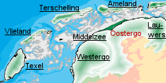
Delimitation: |
Oostergo is bordered by
the Wadden Sea in the north, and by the eastern Middlezee dike in
the west. The Lauwerszee and river Lauwers form the eastern border.
The southern border runs over the Boorne dike to Oldeboorn and then
along the Stroobos canal. |
|
Size: |
around
360 km² |
|
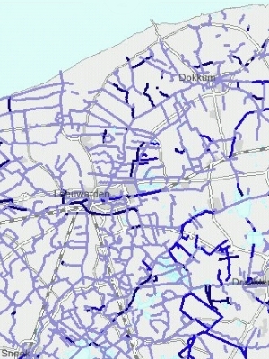
Location
- map: |
Province
of Fryslân, the Netherlandsany |
|
Origin
of name: |
The north part of
Fryslân was bisected by the Middel Sea. The island on the east side
is Oostergo (Oost means east). |
|
Relationship/similarities
with other cultural entities: |
Related
to Westergo, Middelzee and Lauwers |
|
Characteristic
elements and ensembles: |
Open area with salt
marsh embankments on which there were mound (terp) villages at 2-3
kilometre intervals. Very open landscape; dwelling mounds in curved
rows, structures of water ways, (former) seawalls and locks;
historic field patterns; natural water courses, medieval town
centres and village like Leeuwarden and Dokkum, historic farm
buildings, stone houses (zaalstinsen). |

2. Geology and geography
2.1 General
The Oostergo landscape was formed in the Holocene period, (the
current geological period). Around the higher sandy area of the Frisian
Wouden and the peat moors of the Lage Midden a broad band of clay was
deposited, measuring up to 10k wide in the north, and gradually narrowing
towards the south. The river Boorne, which rises in the sand and peat
areas of south-east Friesland, formerly turned northward to the west of
Aldeboarn and discharged into the Wadden Sea.
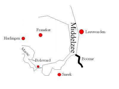 |
| Middelzee with river Boorne |
The Oostergo
landscape is bordered on two sides by large estuaries: the Boorne (Middelzee)
and the Lauwers (Lauwerszee). Marine clay was deposited along the inlets.
The ridge thus formed by the sea is now a salt marsh embankment.
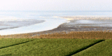
2.2 Present landscape
Oostergo has an open landscape with high dikes offering protection
from the sea. The accretion of land at the coast is a continuing natural
process.
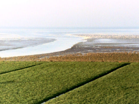 |
 |
| Photo: Accretion of land outside
the dykes |
Dykes in Oostergo |
3. Landscape and settlement history
3.1 Prehistoric and Medieval Times
The earliest permanent settlement was around 600 BC, when people
moved into the coastal area from the Drenthe plateau. The first
inhabitants settled on the highest points: the salt marsh embankments and
high banks of the streams. Initially they lived directly on the
ground-surface of the embankments. Over time however, as sea level rose
and flooding increased, the dwellings had to be raised. Mounds were
created from whatever came to hand; household refuse, manure, clay and
turf, and gradually the first dwelling mounds (terpen or wierden) were
constructed from c. 500 BC. The place-name “wier(de)” also means an
artificially raised dwelling place. A number of terp villages in Oostergo
have the suffix -wier(de), such as Metslawier, Niawier and Poppingawier.
Initially the terps accommodated individual dwellings, but over time they
grew together into raised villages.
 |
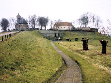
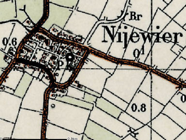 |
| Dwelling mound in Oostergo |
Terp village Nijewier |
The oldest
form of village terp consisted of round, separate terps with plots
radiating out from them, and sometimes a ditch around the foot of the
mound. Examples of such round terps include Foudgum, Hogebeintum, Brantgum
and Oostrum.
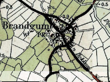 |
 |
| Round terp village Brandgum |
Photo: Village Hogebeintum |
From around
700 – 800 AD a different kind of terp developed as a trading terp. At this
date the Frisian coast was at the crossroads of several important European
trade routes, so trade flourished. The trading terps were largely found on
the banks of a stream, just behind the coast: examples include Aldeboarn
on the Boorne and the old centres of Leeuwarden and Dokkum on either side
of the Dokkumer Ee. This type of terp had an elongated shape with
buildings along a central road.
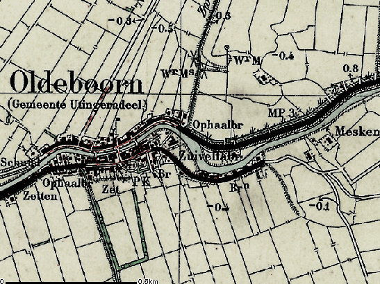 |
| Map of Aldeboarn (Oldebbrn) |
3.2 Early Modern Times
The construction of a continuous sea dike around Oostergo stopped
most of the regular flooding of the land, so it was no longer necessary to
live solely on the high salt marsh ridges. From around the 12th century it
was also possible to live on the lower-lying salt marsh plains. The arable
fields were still on the higher embankments and the flanks of the terps.
The poorer, wetter land around the terp was used for pasture and hayfields.
In the lowest-lying areas, south of Anjum, there are duck decoys,
sometimes as many as four close together.
The continuous dike along the Middelzee and the Wadden Sea was probably
built around 1100 AD. It ran from Deersum via Irnsum, Roordahuizen,
Leeuwarden, Stiens, Holwerd, Wierum and Oostmahorn to Engwierum. If salt
marshes outside the dikes were silted up sufficiently, they were sometimes
also reclaimed and farmed. Once a new dike was built further seawards, the
old dike lost its purpose, and was often dug out. Monasteries established
in the area from 1100 onwards played an active role in dike building and
land reclamation in Oostergo, particularly Mariëngaarde near Hallum and
the Gerkes monastery in the Lauwerszee area.
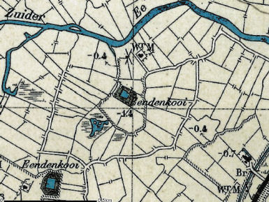 |
 |
| Duck decoys (Eendenkoois) in
Oostergo |
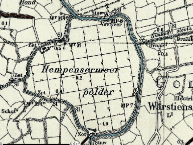
Hempensermeer Polder |
In addition to reclaiming land from the sea, land was also reclaimed in
Oostergo by drying out pools. There are three such small drained pools
south of Leeuwarden: the Hempensermeer and Greate Wergeastermeer polders
and the Lytse Mar polder east of Wergea. These polders were pumped dry in
the 17th and 18th centuries and are characterised by a very regular
rectangular fieldscape that is typical of reclaimed land.
Initially surplus water from the adjoining land in Oostergo was
discharged into the Middelzee. After the polders were made, a quay was
built on the Oostergo side along the Zwette, the ditch marking the border
between Oostergo and Westergo. This made drainage toward the Middelzee
impossible, so the drainage point was moved to Dokkum. A number of
waterways, such as the Huijumervaart and the Heerenwegstervaart, were dug
to solve the drainage problem. Where a stream or waterway discharged into
the sea a discharging sluice or zijl was built in the dike. The
reclamation of the Bildt meant that an important Oostergo sluice in Oude
Leije had to be moved twice. The polder water has been discharged at
Nieuwe Bildtzijl since the 18th century.
In the medieval period peat was dug on a large scale in Oostergo to
extract salt. The dug areas have a distorted soil profile and are still
recognisable in the landscape as elongated lower lying areas, particularly
in De Kolken south of Anjum, and between Wetzens, Jouswier and Oostrum,
where large areas of peat were extracted. In addition to peat extraction,
clay was also taken in some areas to make bricks. Initially these were
used only to build monasteries and churches, but later they were also used
for noble houses, and later still for farms.
While agriculture was still the most important source of income, the
increase in trade meant the development of towns. Dokkum arose where the
Dokkumer Ee flowed into an inlet of the Lauwerszee: the present day
Dokkumer Grootdiep. Two terps were built on the northern side of the
watercourse which now form the centre of the town. In the 12th century the
Norbertine Bonifacius Abbey was built on the northern terp, which is now
the Markt. After the Reformation at the end of the 16th century the Abbey
was demolished. The veneration of Boniface, the missionary and bishop who
was murdered near Dokkum in 754, received a boost in 1925 when the St
Boniface Chapel and garden were built on the south side of the town.
Leeuwarden lies where the (Dokkumer) Ee once flowed into the Middelzee.
There are three terps in the centre of the town which formed the original
urban area: the Oldehove terp, and the terps at the level of the Kleine
and Grote Hoogstraat, which lay on either side of the Ee. From 1200 to
1500 the town expanded significantly, becoming the provincial capital in
1504. It was also significant that Leeuwarden became the seat of the
stadhouder of Friesland. From 1584 to 1747 the stadhouders lived in the
court on the Hofplein.
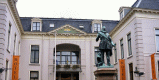
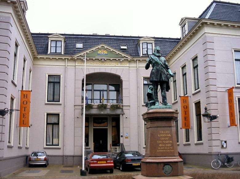 |
| Photo: Stadhouder Hof in
Leeuwarden |
3.3
Modern Times
In the 19th century Leeuwarden became an increasingly important
road and rail hub. As a result it enjoyed modest industrial growth, with
the emphasis on the agricultural sector. New districts were created
outside the historic centre for the growing population.
Waterways were still the major transport routes in Friesland until well
into the 19th century. Streams and rivers had been used to transport goods
since the earliest occupation of the area. Many of these small waterways
were later straightened, or made into canals. A number of major canals
were created for heavier traffic. Most of these were originally natural
watercourses which were made into boat canals in the mid-17th century.
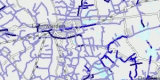
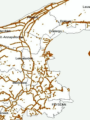
 |
| Old and recent waterways in
Oostergo |
This involved
widening and deepening the channel and creating towpaths. Large-scale
commercial levelling works between 1840 and 1945 left practically none of
the dwelling mounds intact. The fertile soil from the mounds was used to
fertilise agricultural areas elsewhere. To transport the soil the original
terp channel was dredged or a new one was dug, so that the terp was
connected to the network of major waterways in the area. Oostergo also has
a network of roads. The roads traditionally follow the course of the old
dikes over the banks, beside gullies and streams, as these were the
highest and driest parts in the area.
Land acquisition was tackled systematically from the start of the 19th
century. Pits were dug in the salt marsh to catch the silt and mud-flat
sediment. Once they were full the silt was spread over the marsh, and the
process was repeated until the marsh was high enough above water-level.
Large-scale reclamation work was undertaken in 1935, during the time of
mass unemployment. A method was adopted which was then common practice in
Schleswig Holstein, and seems to have come directly from Vierlingh.
Brushwood fences were made to enclose “sediment fields” of 400 by 400
metres. Channels were dug every five metres in these fields, and the
deposited silt was excavated twice a year and spread on the field. Each
field also had two major ditches parallel to the dike. All the channels
emptied into these major ditches, so that the sediment field was drained
at ebb tide and plants could take a good hold. The plants used to
encourage this development were mainly glasswort, salt-marsh grass and
cord grass.
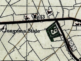
It is thought that there are no surviving mounds left in Oostergo that
were built for defensive stone houses (stinsen), except perhaps the mound
of the former Jongemastate in Rauwerd.
|
Mound of Jongemastate in Rauwerd |
 |
There are also no surviving tower houses left in Oostergo. In the 14th and
15th centuries hall houses (zaalstinsen) were also built, which were more
comfortable to live in than the stone towers. From the 16th century
onwards the stone houses gradually lost their defensive role and became
largely status symbols; they were often converted into stately homes with
estates. Although many country estates in Oostergo were given the title “state”,
they were not all developed from the original stone stinsen. Fine estates
of gardens and forests were laid out around many of the stately houses in
the 17th and 18th centuries.
4. Modern development and planning
4.1 Land use
Oostergo is predominantly under grassland and maize used for livestock
farming. The coastal areas heavy marine clay is more suitable for potato
growing.
4.2 Settlement development
There are two large towns in Oostergo, Leeuwarden and Dokkum, both have
expanded since the Second World War and exert a great deal of influence on
their surroundings. As the provincial capital Leeuwarden has many of the
regional institutions such as hospitals, colleges, cultural institutions
and business activities. Locations for new build neighbourhoods are in the
south and east of the town. In the northern part development has already
taken place in the district 'Bullepolder'.
4.3 Industry and energy
Industry is largely agriculture-based. The harbour activities at Dokkum
are more of a tourist attraction. Leeuwarden is largely a service centre
and has no heavy industry.
4.4 Infrastructure
Leeuwarden is at the hub of water, road and rail routes. There is a
planned ring road on the west and southern part of the city of Leeuwarden.
A new road has also been built from Dokkum to Drachten, the Centrale Axis.
5. Legal and spatial planning aspects
The Legal and Spatial Planning Aspects are described here in a generalised
way, as they are relevant to all the entities in the province of Fryslan.
Because of the scale of the cultural entities (most cover more then one
municipality) the focus is on regional policy and management. However the
goals of regional policy and planning are taken into account by local
sector policy. The regional goals and strategies are formulated after
discussion with a wide range of sectors, stakeholders and organisations.
The regional spatial plan for the province of Fryslân, (the Streekplan),
is an important document in terms of integrated management of landscape
and heritage. This plan details the objectives for regional and local
policy, and issues relating to landscape and heritage
The provincial planning vision for North-East Fryslân centres on
exploiting and reinforcing of the special qualities of the area, to
provide a social and economic boost to the region. The construction of the
Central Axis will start to connect the region to the main road network,
and reinforce the central position of the regional town of Dokkum.
6. Vulnerabilities
6.1 Spatial planning
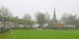
The open space, skyline and structure of the historical cities, towns and
villages are very vulnerable to ill informed planning for new housing and
industry. This is especially the case in and around Leeuwarden and on a
smaller scale in Dokkum.
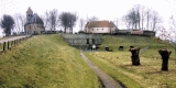
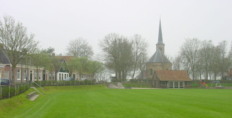 |
| Photo: Village of Weidum |
6.2 Settlement
The growth in the population of the former terp villages often means
extending rather than developing in the existing residential areas.
Allowing new developments to blend in with their surroundings demands a
great deal of care and investment. Industrial estates are often built on
the fringes of the main urban areas. The construction of the Central Axis
will provide opportunities as well as threats. There are no surviving
mounds left in Oostergo that were built for defensive stone houses (stinsen),
or surviving tower houses.
6.3 Agriculture
The historic field pattern, natural watercourses and the historic farm
buildings are vulnerable due to agriculture developments. Many of the
smaller settlements that had been on mounds have already been lost to
agricultural improvements. In rural areas the province aims to combine
sustainable prospects for agriculture with a more extensive range of
activities and services. It is anticipated that agricultural production
will be scaled up considerably, particularly in the clay area. Continued
agricultural practices will disturb or destroy buried archaeological
deposits.
7. Potentials
7.1 Spatial planning
The proposed residential and industrial development should consider the
cultural heritage, both in terms of recording prior to development and
management of known sites. Within the historic core of the towns and
cities careful planning should protect the historic layout and surviving
buildings.
7.2 Settlement
Some of the historic settlements survive and these could be promoted for
tourism. The dispersed settlement pattern of small villages and farmsteads
have the potential to be promoted via tourism for their cultural heritage.
The histroic settlement patterns, now largely lost to modern agrculture
could be promoted via museums etc. Well designed conversions and
extensions can allow historic buildings to fulfull the demand for new
housing and small scale industrial uses.
7.3 Agriculture
Sustainable agriculture in relation to meadowland, migrating birds and
cultural historical elements contribute to the development of tourism.
There is potential for disused agricultural buildings to be used for new
housing, holiday accomodation or new small scale industrial enterprises
and for development of locally specific brands of agricultural products.
7.4 Tourism
The area has clear potential for landscape and cultural history tourism.
Using historic buildings and farmhouses for accomodation, old paths for
walking and cycling and old water ways for pleasure shipping is already
practised and should be promoted further. The restoration and management
of cultural features will encourage a wider interest via tourism in the
area. One of the most striking features of Oostergo is the dike system
which has the potential to be promoted as a significant tourist attraction
especially for walkers and cyclists.
7.5 Cultural hertiage
The restoration and development of area specific features such as the
former shrimp catching and processing in Wierum, brick producing in
Oostrum and the old garden from Jongemastate in Rard provide the
opportunity to exploit the areas cultural heritage.
8. Sources
Marrewijk, D & A.J. Haartsen, 2002, Waddenland Het
landschap en cultureel erfgoed in de Waddenzeeregio, Ministerie van
Landbouw, Natuurbeheer en Visserij / Noordboek, Leeuwarden
Provincie Fryslan, 2006, Streekplan. Leeuwarden
|