|
1. Overview
|
Name: |
Terschelling |
|
Delimitation: |
Island in the Wadden Sea |
|
Size: |
ca. 90
km² |
|
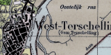
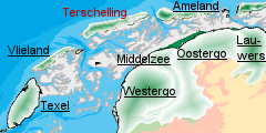
Location
- map: |
Province of Fryslân |
|
Origin of name: |
not known |
|
Relationship/similarities with other cultural entities: |
Relationship with Ameland and Vlieland, neighbour islands. |
|
Characteristic elements and
ensembles: |
The
island consist of dunes with a string of settlement on the east-west
line and polders (former salt marshes) south of it, dwelling mounds,
duck decoys, lighthouses. |

2. Geology and geography
2.1 General
Terschelling is one of the Frisian Wadden Sea islands off the
northern coast of the Netherlands that separate the Wadden Sea and the North
Sea. The natural landscape arose from an elevation of the sea level after
the last ice age. The rise in sea level was accompanied by a corresponding
rise in fresh groundwater level and the creation of a zone parallel to the
coast where peat was able to develop on a large scale. Clay and sand were
deposited on this peat layer facing the sea, while the peat on the landward
side spread out over the more elevated sandy areas. As a result of the
flooding of the Strait of Dover, the sea current changed direction and began
to run more in parallel with the coast. This gave rise to a series of
low-lying dune ridges, broken by rivers flowing into the sea. Following
later marine incursions, the peat behind the ridges was eroded and the
ridges were divided up into smaller pieces: the Wadden Sea Islands.
Terschelling is characteristic of islands in a dynamic coastal area, with
erosion in some areas and deposition in others. The islands shape is also
determined by the strong sea current.
Like the East Friesian Wadden Sea islands of Schiermonnikoog and Ameland,
Terschelling is an elongated island which becomes narrower to the east, with
villages sheltering in the dunes. In addition the island has an area of
reclaimed salt marsh, hook-shaped sandbars on the western side and extensive
dunes and salt marsh flats on the eastern side.
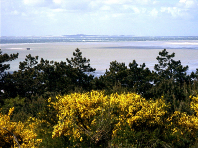
 |
Dunes
and salt marsh flats on the eastern side of Terschelling (Boschplaat) |
The open salt
marshes have been protected in many places by a dyke against flooding from
the Wadden Sea, but Terschelling also has an area without dykes and
submerged at high water. There is a detailed policy for the coastal
protection for the eastern and western parts, and dynamic coastal management
is practised, enabling the natural process of erosion and accretion to take
place. Like the other islands, Terschelling has a natural tendency to shift
to the east.
 |
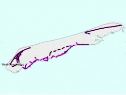 |
 |
| Villages, |
dykes |
and coastal protection on
Terschelling |
2.2 Present landscape
At 30 km in length Terschelling is the longest of the Friesian Wadden Sea
islands. Its strategic location means that Terschelling has been involved in
numerous wars, in which both the villages and ships were repeatedly burnt.
 |
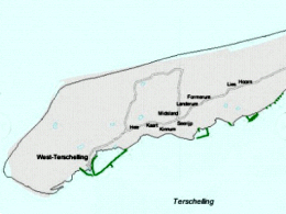
| Earth-mound settlement on Terschelling |
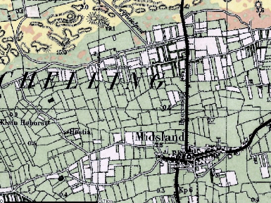
The island has seven villages and a number of earth-mound settlements in the
salt marsh area. The village of West-Terschelling has traditionally been a
settlement for fishermen, pilots and captains and mariners. The other
villages of Oosterend, Hoorn, Lies, Formerum, Landerum and Midsland lie in
the lee of the dunes on an old beach ridge and are more agricultural in
nature. The structure of the villages of Formerum and Midsland is
reminiscent of the geest villages in North Holland, with a road running
along the foot of the beach ridge. In addition there are a number of small
earth-mound settlements in the salt marsh area, such as Kaart, Kinnum and
Seeryp. West-Terschelling and Midsland are densely populated, while the
other villages have lower-density housing.
3. Landscape and settlement history
3.1 Prehistoric and Medieval Times
Agricultural activity on Terschelling consisted mainly of livestock
farming, with the cultivation of vegetables and cereals, both for human and
cattle consumption. The vegetables and cereals were cultivated around the
built-up areas on the sand ridges. The row of villages and the dunes were
separated by areas used as hayfields, since the seepage from the dunes gave
rise to a boggy and peaty area. These haylands on Terschelling were
surrounded by alder groves. The trees were often planted on the damp side of
ditches, so that the precious agricultural land could be used as efficiently
as possible. On Terschelling there are remains of two hill fortifications,
near Oosterend and Lies. Both of these were built by the Friesian family,
Popma. The activities of the Popma?s in eastern Terschelling prove the
agricultural and maritime importance of this part of the island.
Additional income was also earned from the duck-decoys, of which seven still
survive. A duck decoy consists of a lake, the cage-pond and one or more
tunnels. The area is surrounded by a wood or swamp forest where ducks can
rest on the water and take refuge from the wind. The size of the demarcated
area varies, as do the shape and layout of the cages. There are various
types of decoy, characteristic of North Holland, the island of Texel,
Friesland and Terschelling itself. The latter two types provided a model for
the cages on the German Wadden Sea islands.
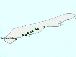
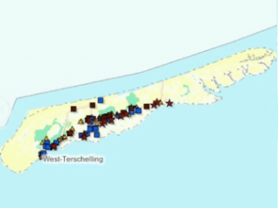
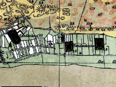 |
Map of
several duck decoys (eendenkooi) on Terschelling |
3.2 Early Modern Times
For a long time agriculture formed an important but restricted source
of income for the island population. There were however other means of
making a living. From Hanseatic times the Wadden Sea area lay on the most
important maritime trade routes. The switch in focus of trading activity
around the Zuiderzee from the east to the west coast saw the emergence of
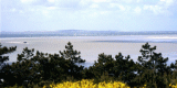
towns such as Hoorn and Amsterdam. West-Terschelling benefited from this
relocation of trade, since the shipping route to the North Sea ran via the
Vlie channel between Terschelling and Vlieland. Seafarers and pilots settled
in the area. The provisioning and pilotage of ships became an important
activity for Terschelling, as they were in Vlieland, and West-Terschelling,
in particular, was able to develop into a port.
 |
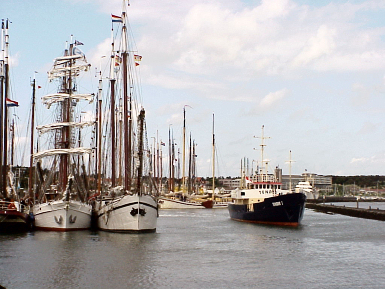 |
| Photo: View from Terschelling to
Vlieland (Vlie channel) |
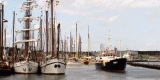
Photo: Port of Terschelling |
The economic
boom of the Golden Age is reflected in the characteristic Commodore's houses
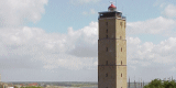
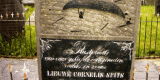
of former ship's captains. West-Terschelling is also the site of the
Brandaris lighthouse, which dates from 1594 and is the oldest surviving
lighthouse in the Netherlands. The Brandaris was built at the expense of the
States of Holland, after the former light beacon was engulfed by the sea. A
special feature of this lighthouse is the cemetery located at its foot, the
images and inscriptions on the gravestones provide a reminder of the past
maritime connections of the local population.
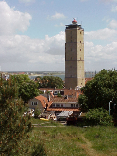 |
.jpg) |
| Photo: The 'Brandaris' lighthouse
from 1594 |
Photo: Gravestone at the foot of
the Brandaris |
As late as 1874
Terschelling was still producing most of the mariners for the Dutch merchant
navy. Terschelling?s close links with merchant shipping and fishing resulted
in the establishment in 1875 of the Willem Barentsz nautical school (college).
|
Location
of Willem Barentsz nautical school |
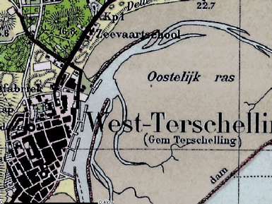 |
This, together with the central location of the island, mean that a number
of important nautical services have been established on Terschelling, such
as the navigation channel marking service, the Traffic management on the
Brandaris lighthouse, which is also the Wadden Sea Central Incident calling
post.
3.3 Modern Times
At the end of the 19th and in the early 20th century, with the introduction
of fertilisers and the commercial availability of animal feed, agriculture
became more productive. Agriculture on Terschelling then came to concentrate
increasingly on dairy farming. Terschelling has a number of farms built
between 1850 and 1930 that are unique in terms of both shape and layout.
These are of the head and trunk type, a highly characteristic feature of
which is the laterally protruding saddle roof, known locally as a schúntsje.
Land re-allotment took place between 1947 and 1950, when the highly
fragmented and small plots were substantially enlarged and made more equal
in size. The former arable fields were converted into meadows, the water
level in the polder was substantially reduced and the drainage was improved
by the installation of drainage channels.
 |
Highly
fragmented fields on Terschelling |
New roads were also constructed and old dykes cut away. Characteristic of
the present island economy is the cranberry. The cranberry washed ashore by
chance in the 19th century and then took root on a massive scale in the damp
dune valleys. The fruit is used in all sorts of local Terschelling products,
such as cranberry wine. The dune valleys where it is commercially grown
require special management. This resulted in substantial changes to the
landscape during this period. The land re-allotment also meant that a large
part of the characteristic Terschelling haylands was lost.
4. Modern development and planning
4.1 Land use
At the end of the 19th century there were approximately 240 farms on
Terschelling. At present there are still around 20 operational dairy farms,
which maintain all the agricultural land.
4.2 Settlement development
Tourism became an increasingly important factor in the 20th century. Of the
Dutch Wadden Sea islands, Terschelling was very much a latecomer in the
tourism field; with agriculture and maritime business long remaining the
most important sources of income for the island. However, nowadays tourism
is the most important economic activity on the island and the municipality
of Terschelling wishes to intensify tourism activities. There are many
tourist bungalows and camping-sites on the island, particularly along the
border line between the dunes and the villages. Due to the developments in
tourism part of the old houses were converted to second (tourist) homes.
Nowadays it is a struggle to find appropriate places to build new houses for
the local population.
4.3 Industry and energy
The business sector is locally orientated and largely determined by the
tourist sector. There are only very small industrial activities.
4.4 Infrastructure
The main road is west to east. Apart from the paved roads to the
beach and in the villages the infrastructure consists mainly of bicycle
roads. The good accessibility of many parts of the island by foot or bike is
especially important for tourism benefits, where necessary new connections
made.
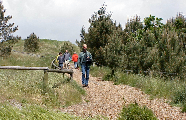 |
| Photo: Tourists in the dunes of
Terschelling |
5. Legal and spatial planning aspects
The Legal and Spatial Planning Aspects are described in a general way, as
these are relevant to all the cultural entities in the province of Fryslƒn.
Due to the scale of the cultural entities (which cover more then one
municipality), the focus is on regional policy and management. However, the
goals of the regional policy and planning strategy are taken into account by
the local sector planning policy. The regional goals and strategies are
formulated after discussion with a wide range of stakeholders and
organisations.
The regional spatial plan for the province of Fryslƒn, called Streekplan, is
an important document in terms of the integrated management of landscape and
heritage. This plan presents objectives for regional and local policy, as
well as considering issues of landscape and heritage. At this moment (mid
2006) the province of Fryslƒn is finalising her new regional spatial plan.
The essential qualities of the different landscapes of Fryslƒn are described.
These qualities are seen as important and should be taken into account when
making planning decisions. The recognition of the essential qualities of the
landscapes, and the strengthening of them, is a primary objective. The plan
(Streekplan) emphasises the need for protection of the historic landscape
and protection by development.
In provincial (spatial) policy, the Frisian islands have a special position
because of their very specific situation. The landscapes, the nature and the
cultural heritage is highly valued, and the space for development is limited.
The general policy for further development is to look for opportunities for
improving the quality of the existing supply, instead of further expansion.
Terschelling has a specific zoning plan and a regional management plan for
the areas of national interest.
Terschelling has a specific zoning plan and a regional management plan for the areas of national interest.
6. Vulnerabilities
6.1 Settlement
The expansion of tourism has resulted in a large number of properties
becoming second homes or holiday properties. This results in added pressure
to expand the settlements with the threat of altering their historic
character. The re-use of buildings on the farmyards doesn?t always fit in to
the historic character of the island.
6.2 Agriculture
Agriculture is an important part of the economy of Terschelling, although it
is in decline. In the recent past, agricultural improvements have
significantly altered the historic field pattern. The scale of the farms is
small and as a result they need to look for alternative supplementary
incomes, frequently via tourism. The challenge remains to look for new ways
to maintain sustainable agriculture on the island.
 |
Places of accommodation
on Terschelling |
6.3 Tourism
The development of tourism over the last decades has resulted in significant
changes to the landscape. The major expansion of tourist accommodation is
more visible in the open landscape south of the villages and has
significantly changed the settlement pattern. The existing holiday
accommodation is also becoming redundant as new forms of tourist
accommodation are wanted. Lack of investment in the quality of the tourist
infrastructure by entrepreneurs can lead to a decline in the tourist economy,
as is being seen in the area behind the dunes, with a potential impact on
the maintenance of the historic landscape and cultural heritage.
6.4 Nature conservation
Nature protection is important on the island and measures for nature
protection, such as the removal of field boundaries, have sometimes been in
conflict with existing values of the historic landscape.
6.5 Natural processes
A continual process of erosion is taking place which threatens cultural
heritage assets on the island.
7. Potentials
7.1 Settlement
Trade, fishery and agricultural land use, and early tourism, have left their
marks in the character of villages and fields. The many dispersed farms and
small villages on Terschelling with their varied character are well
preserved.
7.2 Agriculture
The growing awareness of the importance of the local agricultural economy
for the landscape and heritage should be encouraged with the potential of
promoting local produce and retaining historic farming methods.
7.3 Tourism
The policy for sustainable tourism for the Wadden Sea islands supports some
growth in the quality and diversity of tourism on Terschelling. Tourists are
seeking higher quality and wider choice in the holiday accommodation and
activities provided and this provides great potential both for the
management, promotion and preservation of the cultural heritage of the
island. The good accessibility of many parts of the island both by foot or
cycle provide the potential for the creation of cultural heritage routes or
integrated cultural heritage and natural environment trails. Overall, more
then 40% of the employment on the Dutch Wadden Sea islands is directly
related to tourism providing a major oppertunity to promote the cultural
heritage of the island.
7.4 Nature Conservation
Nature protection is important on the island and these areas provide the
potential for integrated management planning, for the protection,
enhancement and promotion of both the natural environment and cultural
heritage. The islands duck decoys are a good example of where this could
apply.
7.5 Marine history
The bay of West-Terschelling with it?s lighthouse (de Brandaris) is unique.
It is the only harbour in a natural bay in the Netherlands. The island of
Terschelling is working on upgrading the harbour and ferry area of West
Terschelling. There is the potential for the cultural heritage of the area
to benefit from these investments.
8. Sources
Marrewijk, D & A.J. Haartsen, 2002, Waddenland Het
landschap en cultureel erfgoed in de Waddenzeeregio, Ministerie van Landbouw,
Natuurbeheer en Visserij / Noordboek, Leeuwarden
Provincie Fryslan, 2006, Streekplan. Leeuwarden
Provincie Groningen, 2000, Provinciaal Omgevingsplan, Koersen op Karakter,
Groningen
|