|
1. Overview
|
Name: |
Amrum |
|
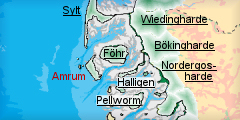
Delimitation: |
Island in North Frisia, neighbouring entities Sylt, Föhr and Hallig islands |
|
Size: |
20.5 km² |
|
Location
- map: |
Island in the very north-west of North Frisia, Schleswig-Holstein, Germany |
|
Origin of name: |
|
|
Relationship/similarities with other cultural entities: |
Relationship/similarities with other cultural entities: Clustered villages like on Föhr and moraine mainland, built heritage like farmhouses, churches, residential houses, field enclosures with low banks as on Föhr, heath land, burial mounds and megalithic tombs as on Föhr, Sylt and mainland moraines, spa architecture as on Sylt, Wyk on Föhr |
|
Characteristic elements and
ensembles: |
Clustered villages with irregular fields enclosed by hedgerows, Uthlande style farmhouses with Frisian walls, medieval churches, spa buildings, heath land, burial mounds and megalithic tombs, prehistoric and early historic remains underneath dunes |

2. Geology and geography
2.1 General
The island of Amrum is the smallest of the three Geest islands Sylt, Amrum and Föhr in the Wadden Sea of Schleswig-Holstein. Situated south of Sylt, both islands describe the westernmost border of the Wadden Sea area of Northern Frisia, their western shores indicating an early, former coastline till medieval times. Its moraine core, stretching in crescent shape from north to south, belongs as relics of Salle ice age glaciers to the oldest parts of the Wadden Sea region and provides the largest share of the actual island, apart from the extensive dunes in the west and small areas of marshland east of the northern tip and in the south. During roughly 150 years the sandbank of Kniepsand, before situated in the Wadden Sea west of the Island, has gradually merged with its dunes, providing the island with one of the widest beaches in Europe. This huge, desert-like area with dunes up to 32 m high had constantly changed under the influence of wind and the sea and also moved further east, covering a treasure chest full of prehistoric settlements and burials till plantations halted the motion.
2.2 Present landscape
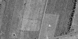
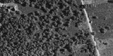
Four different landscape zones, roughly following the crescent shape of the island, can be distinguished on Amrum. The western and southern border to the North Sea is marked by the wide sandy beach of Kniepsand which is without any built structures. A unique variety of different types of dunes follows to the east, mixed with swampy depressions in low lying areas, often inundated during the cold seasons and covered with vegetation for the most parts, giving it the appearance of green hillocks. A belt of forest, planted on former heath land, limits the dunes extension to the east and reaches out into the dunes at some places. The inhabited part of the island lies in the east with few clustered villages and open land, mostly used as paddocks and some agriculture. The mostly treeless fieldscape is characterized by co-axial, rectilinear strips in an east-west arrangement in the north and irregular, often sinuous fields in the south of Nebel.
 |
| Forest, heathland and
fieldscape of sinuous fields in the south of Nebel.
© ALSH |
Especially around the villages of Nebel in the middle and Norddorf in the north are larger areas of modern residential buildings, reaching into the forest. Wittdün and Süddorf are more loosely built. All built-up areas are tree-lined. The buildings are usually in a low, traditional style, whereas the historic windmills and churches stand out as landmarks. Wittdün as has some multi storey constructions. Few single farmsteads and some larger building complexes like sanatoriums are situated between the villages or in the dunes. The small, open and treeless marshland areas are intersected by rectilinear drainage ditches and winding vestiges of tidal inlets. Burial mounds are highly visible in these parts. As a fifth landscape type, the island is accompanied by extensive mud flats in the east connecting it to Föhr.
3. Landscape and settlement history
3.1 Prehistoric and Medieval Times
The earliest settlements can be traced back to the late Stone Age, represented by megalithic tombs and followed by ample mounds, cemeteries, field systems and other vestiges of prehistoric settlement of later periods and medieval fields, often preserved under the dunes, like the Iron Age site of
Düwdeal with traces of fields, burials and parts of an embankment near Norddorf. Especially the numerous mounds often form highly visible landmarks like the mounds of
Klaffhugh near Süddorf,
Esenhugh near Steenodde and
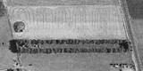
Heeshugh near Nebel. Drifting sand from the dune belt had turned agricultural land and some eastern dune areas into heath land which subsequently used to cover large parts of the island. Removal of top soil for fertilising in these areas and extensive grazing preserved this landscape type for centuries. Villages and farms frequently had to be moved further east due to erosion at the west coast and the advancing dunes, like at Sylt. Most interesting are parts of embankments of unknown time like the
Krümwal near Süddorf, the
Hiadwall south of Norddorf or the probable dike
Auergruftswall north of Norddorf.
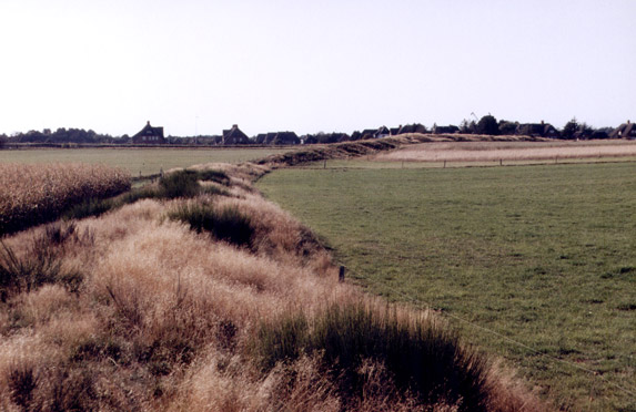 |
| The ancient embankment of
Krümwal near Süddorf.
© ALSH |
Comparably few medieval remnants are known, the most impressing one being the Romanesque church,
St. Clemens in Nebel, built in the 13th century and extended by a detached, solid belfry only in 1908. The original settlement pattern of few villages, loosely built around a centre like in
Nebel, is nowadays only partially visible. Herring fishing around Helgoland brought moderate income to Amrum in the 15th and 16th century, where agriculture decreased in importance and had to be maintained mainly by the women of the seafarers and elderly people.
3.2 Early Modern Times
A good quantity of intact Uthland-style farm houses of the 17th and 18th century, typical for Northern Frisia, are clustered in Nebel and Süddorf. During the 17th and 18th century many islander served mostly on whaling and trading vessels from Hamburg or engaged illegally as wreckers and acquired some wealth with their businesses which they invested in representative, traditional houses in the Uthlande style. The captain’s house "Öömrang Hüs" in Nebel, built in 1736, is used as a museum today. Coastal trade with small local vessels and oyster fishing, which was run in Stenodde till 1910, were other source of income. Many grave slabs of seafarer of this so-called Golden Age can still be found on the cemeteries. The oldest
Dutch windmill in North Frisia is found in Nebel. It was built in the 18th century, together with another, still existing one in Süddorf, and serves as museum today. The constant westward movement of the extensive dunes has been halted since the end of the 18th century when the Danish administration began with plantations on the dunes. At around the same time, the traditional, common use of land for grazing ended, when all the commons were divided among the farmers, which promoted the intensification of agriculture in the following decades.
3.3 Modern Times
Since the island became part of Prussia and consequently of the new German state in the late 19th century and especially after World War II most of the heath land has disappeared and turned into agricultural land or plantations. The forest belt separating the dunes from the rest of the island is the result of these planned activities. Many typical dwelling houses of these decades, brick built and with thatched roofs according to the traditional style, can be found in
Norddorf and
Wittün, which itself was founded only in 1890 as spa. Health resorts of this kind had been already especially popular on Föhr and Sylt at that time. The catching of birds was enhanced to a larger scale by
duck decoys, artificial pools, of which one in the south and one in the west of the island are still to be seen. The respectable
lighthouse of 1875 finally filled a gap in navigation points in the Wadden Sea. The modern children
sanatorium at Satteldüne was, like some other facilities of the kind on the island, originally built shortly afterwards for pensioners of the Prussian cavalry. A train connection between the villages shortly existed in the first half of the 20th century, beginning with a track between Wittün and the Kniepsand sandbank in 1893, before the increasing importance of new roads, built in the 1930ies, put an end to it. A gap within the protecting dune belt at
Risum, north of Norddorf, leading to frequent inundations, was closed with a dam in 1917. The accumulated marshland east of this dam was embanked about 15 years later, creating the only polder on Amrum. During the later part of the 20th century the number of houses, especially second homes, increased dramatically leading to untypical widespread settlement structures at
Westerheide and south of Norddorf. The dunes are nowadays mostly nature related but intersected by wooden trackways.
4. Modern development and planning
4.1 Land use
TAgriculture plays, as with Sylt, a minor role in the islands economy due to small areas of arable land with comparatively poor soil quality and very small stretches of marsh in the east. It is further declining and will further take hold of offers for set-aside of land or other, more nature protection related models. Fishery scarcely exists anymore. Only one fisherman is left of this important local business. More important is nature protection on an island as the island boasts of extensive dunes, the largest sand bank in the region and parts of remaining heathland and modern forests. Therefore, Amrum has a high density of biotopes and protection areas. There is a discussion about a golf course between Nebel and Stenodde. Land is often used as paddock for ponies. Cropping and animal breeding has recently intensified again. There are approaches to use the salt mashes for
grazing.
4.2 Settlement development
The traditional settlement structure is heavily blurred by new settlement areas. Being a focus region for tourism, new building activities can only be implemented at restricted areas and have to be co-ordinated with other measurements affecting tourist relevant aspects like landscape. Houses outside Wyk usually have no more than two floors. The island’s economy depends on tourism to a larger degree than most other parts of Schleswig-Holstein. Tourism here is, however, on a decline and guests for sanatoriums are not regarded as appropriate substitution.
4.3 Industry and energy
There is no industry and there are no wind power stations on Amrum.
4.4 Infrastructure
The island can only be reached by ferry. The harbour of Wittdün provides a tide-independent connection to Dagebüll in Bökingharde via Wyk. The few roads are narrow and need to be used by cars, cyclists together. Walkers have some paths for their own use. High parking fees in Dagebüll promote the increasing transfer of cars to the island.
5. Legal and Spatial Planning Aspects
All important monuments are protected. The island has two large natural reserves (dunes and northern tip) and a landscape protection area between Norddorf and Wittün across the island. Other areas like the heathland or the beach meadows bear the prerequisites for protection. The primary dunes are regarded as international important wetland according to the RAMSAR convention. The Kniepsand or the cliff near Stenodde are listed as geological important areas. Many of the areas between the settlements have a landscape protection status. Nature protection aims at further integrating agriculture and promoting extensive stock breeding and contract based nature protection. The tourism concept for North Frisia promotes a sustainable development in this sector. An improvement of landscape related tourism together with riding, cycling and hiking is suggested by landscape planning.
6. Vulnerabilities
Many prehistoric monuments, especially mounds, have been levelled and are invisible or have totally disappeared nowadays. Potentials are still left for new building areas for second dhomes. Also, demand for further tourist buildings as well as new developing areas for the inhabitants of the island still poses pressure on the already rather built-up landscape.
7. Potentials
Many old buildings are still extant and in a rather original appearance. The island has a rich archaeological heritage, especially from the Stone, Bronze and Iron Age. The forest belt gives Amrum a singular appearance and feature among the islands of Schleswig-Holstein. It is planned to improve the appearance of Wittdün as entrance to Amrum. The status as a health resort and spa promotes a more constant number of visitors all year around. The historical richness of the island, especially the prehistoric values, could be integrated into tourism on a much larger scale. Especially nature related activities like hiking, riding and cycling can be combined with historic landscape routes. More extensive land use lessens the impact on prehistoric monuments and supports more traditional landscape scenery, also useful for tourism. Cultural issues are best suited for strengthening the local image for marketing purposes.
8. Sources
Author: Matthias Maluck
General literature:
Vollmer, et. al. (eds.) 2001. Landscape and Cultural Heritage in the Wadden Sea Region – Project Report. Wadden Sea Ecosystem No. 12. Common Wadden Sea Secretariat. Wilhelmshaven, Germany.
Innenministerium des Landes Schleswig-Holstein (eds.) 2004. Regionalplan für den Planungsraum V, Amendment File.
Ministerium für Umwelt, Natur und Forsten des Landes Schleswig-Holstein (eds.). Landschaftsrahmenplan für den Planungsraum V. Kiel 2002.
Kunz, H. & Panten, A. 1997. Die Köge Nordfrieslands. Bredstedt.
Bantelmann, Landschaft und Besiedlung Nordfrieslands in vorgeschichtlicher Zeit (Husum 1992)
Bantelmann, A. (ed.) 2000. Das große Nordfrieslandbuch. Bredstedt.
Gemeinsames Wattenmeer Sekretariat (ed.) 2005. Das Wattenmeer. Theiss Verlag Stuttgart.
Beseler, Kunst-Topographie Schleswig-Holstein (Neumünster 1969)
Braun, Strehl (eds.), Langhaus und Winkelbau. Uthlandfriesische Bauformen im 18. und 19. Jahrhundert (Bredstedt 1989)
Vogel, Der nordfriesische Geestrand, die Entwicklung seiner ländlichen Siedlungen und ihrer Flurformen (Bräist/Bredstedt 1996)
Fohrbeck, Schikotanz. Die Region „Uthlande“ Ein Regionales Entwicklungskonzept (unpublished)
Segschneider, M. Die Marschen der Insel Föhr und der Wiedingharde, Kreis Nordfriesland. PhD thesis Kiel 2004
Hansen, M, Hansen, N, (ed). Amrum. Geschichte und Gestalt einer Insel. 1992 (?)
Amrum. Landschaft, Geschichte, Natur, 1991
Fahrenkrug et. al. Regionales Entwicklungskonzept Nordfriesland. unpublished, 2003
C. Heinze, S. Matusek, L. Rättig, A. Struckmeyer, Amrum – Landschaftsplan. unpublished, Kiel 2006
Maps:
Archaeological monument record of Schleswig-Holstein and gis mapping
Lancewad data base and gis maps
Royal Prussian ordnance survey of 1879
Map of H. du Plat of 1804/05
Map of J. Mejer, 1648
Map of J Meier, 1648, Reconstruction of landscape in 1240
Comments:
Especially tourism needs to take further account of landscape and cultural heritage. Recommendations on county and regional scale often mention sustainable developments and integration of landscape and nature as well as they recommend further improvement of culture and nature related tourism. Measurements for realisation, concrete integration in sector aims and models are, however, totally missing. This proofs that just writing it down can only be the very beginning. Furthermore, information on landscape and cultural assets are very scarce and superficial. Recommendations, like to integrate buildings into landscape, don’t base on substantial definitions. Landscape model still focus mainly on nature aspects and also fail in realising goals into measurements and recommendations integrating cultural assets.
|