|
1. Overview
|
Name: |
Föhr |
|
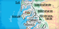
Delimitation: |
Island in North Frisia, neighbouring entities Amrum, Sylt, Halligen and Bökingharde on the mainland |
|
Size: |
82 km², 12 km from south to north, 6.8 km from east to west |
|
Location
- map: |
Island in the centre of the Wadden Sea of North Frisia, Schleswig-Holstein, Germany |
|
Origin of name: |
The name is probably derived from „fahren” and describes a place where people travel to.
|
|
Relationship/similarities with other cultural entities: |
Clustered villages like on Sylt and moraine mainland, built heritage like farmhouses, churches, residential houses, lighthouses as in other entities, field enclosures with low banks and hedgerows as in Südergosharde, heath land, burial mounds and megalithic tombs as on Sylt, Amrum and mainland moraines, spa architecture as on Amrum, Westerland on Sylt |
|
Characteristic elements and
ensembles: |
Clustered villages with irregular fields enclosed by low banks, Uthlande style farmhouses with Frisian walls, medieval churches, spa buildings, heath land, burial mounds and megalithic tombs |

2. Geology and geography
2.1 General
The island of Föhr is, together with Sylt and Amrum, one of the three Geest islands of the Wadden Sea coast of Schleswig-Holstein. The southern part of the island consists of remains of moraines from Saalian ice age glaciers. This moraine core extends about 12 km from east to west. Standing up to 13m above the average high tide level, it is not as severely affected by storm floods than the marshland areas and protected by the frontline islands of Sylt and Amrum. There is, however, a certain loss of land caused by the constantly gnawing waves in the west and south of the island, often unveiling traces of old settlements from Roman Times. Thus, at some lower cliffs have formed, of which Goting Kliff is the most remarkable, today secured by sand replenishment at the seaside. Unlike the other two geest islands of Schleswig-Holstein, the major part of Föhr consists of marshland which has developed north of the moraine core since early medieval times. Dunes play only a minor role at the southern shores of Föhr, in contrast to the extended sandy beaches in the west of Sylt and Amrum.
2.2 Present landscape
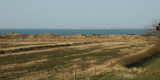
The island of Föhr is divided into two very different landscapes. The north of the island consists of low and flat marshland, rather irregularly divided by ditches and canals and cut by a road parallel to the edge of the moraines in the south and other perpendicular roads. The marshland area is encompassed and protected by a dike as outer sea wall which is visible from afar in this open, almost treeless land. Few new farmsteads and some duck decoys, both surrounded by trees, speckle the marshes. Some tall and highly visible wind power generators were installed in the north-east. The Geest in the south has more relief and hosts, protected by its elevation, all of the villages and the town of Wyk. The latter covers with its modern and often spacious, forested residential areas and the more densely built centre with some multi-storey buildings the eastern corner of the moraines. A park-like golf course and an airfield mark the western border of Wyk. The villages are either clustered or aligned parallel towards the marshland. The buildings are usually in a low, traditional style, whereas some historic windmills and churches stand out as landmarks. Few single farmsteads are situated between the villages. The agricultural land in the west is divided by hedgerows into irregular enclosures. Small forests in the east and west of the moraine Geest also interrupt an open view. The Godel creek forms a small lowland area in the south-west of the Geest, which is only separated from the sea by a narrow ridge.
3. Landscape and settlement history
3.1 Prehistoric and Medieval Times
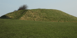
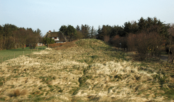
Megalithic tombs and burial mounds from the Bronze Age display the oldest
traces of settlement which then continue throughout the Bronze and Iron Age
to the early Middle Ages, represented by old fields and burial mounds, which
often form highly visible landmarks like the mounds of
Tribergem.
 |
|
Mounds of Tribergem. ©
M. Vollmer |
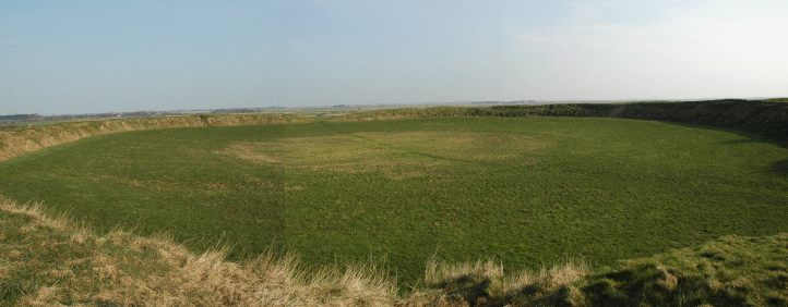
The archaeological heritage is still rich with the remarkable
Lembecksburg, a circular earthen fortification from the early Middle Ages, as highlight, although of formerly hundreds of burial mounds, most have vanished during the cause of time and especially in recent decades by
e.g. ploughing. Numerous low ridges in the area south of
Utersum and on the Geest between
Nieblum and Wrixum need to be properly identified
yet.
 |
|
Circular fortification of the Lembecksburg.
© M. Vollmer |
Remnants of settlement from Roman and Viking times are also found on the marshy part, indicating it to be among the oldest marshland areas in North Frisia, not destroyed by the catastrophic floods of the earlier centuries. The oldest buildings of brick and tuff construction are the so-called Frisian Cathedral of
St. Johannes in Nieblum and two other simple Romanesque churches of 12th and 13th century origin in Wyk-Boldixum and Süderende. Intensive land use and removal of top soil had turned agricultural land into unfertile heath land at the time which used to cover large parts of the island till Modern Times. Vestiges are still extant at Toftum.
|
 |
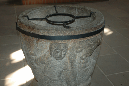 |
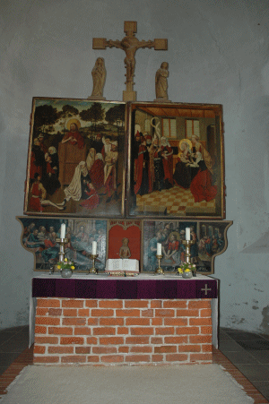
|
Altar and baptismal font of St. Johannes church in Nieblum
©
M. Vollmer |
3.2 Early Modern Times
The relatively secure situation may also be the reason for the late
embankment of the whole marshland in the 16th century, although earlier ring
dikes, like around Ackerum, probably existed.
Many ponds along the dikes testify to the building of the embankments and
their frequent fixing as a law required the material to be obtained from
inside the marshland. Yet, as the level of the tides increased in the late
Middle Ages and salt marsh areas especially in the north were destroyed by
storm surges, settlement from the 16th century on has almost exclusively
taken place on the more elevated Geest where farms on narrow strips of land
were oriented towards the marshland, connected with two roads running in
parallel lines along the edge of the Geest. In villages like
Midlum,
Oevenum and Toftum,
this structure is still impressively well conserved. Other settlements like
Nieblum, not directly connected to the marshland,
were arranged as clustered villages, relatively loosely built around the
centre with only a few newly added development areas for houses. The typical
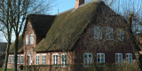
Frisian houses are still frequently visible either as originally preserved
or restored buildings dating back to the 17th century or as modern copies
more or less closely oriented towards the traditional style. Some especially
rich farm houses of the Uthlande style were built by Frisian seafarers who
invested their fortunes, gained abroad, here. These houses were often extended by annex
buildings to angular or square structures. Almost all have been converted
into holiday apartments, only two farmsteads in Utersum and
Midlum are still
used for the original, agrarian purposes. Five Dutch windmills of the 18th
and 19th century have survived out of a number of one for each village,
which are in a good condition, although out of use, like the one in Wrixum.
Herring fishing brought moderate income to Föhr, but when the shoals
subsided by the end of the 16th century, a new means of subsistence could
luckily be found on whaling ships of Hamburg and Dutch ownership bound for
Greenland and Svalbard. Grave slabs around the historic churches sometimes
tell complete life stories. Agriculture, which decreased in importance, had
to be maintained mainly by the women of the seafarers and elderly people.
The common work on whaling vessels was eventually replaced by the even more
profitable employment on trading ships, which lead to a short economic bloom
furnishing the more splendid sitting rooms, ending rather abruptly by the
Napoleonic continental blockade. Common land had to be enclosed and divided
among the farmers by the end of the 18th century by order of the Danish
administration, which was only responsible for the western part of the
island. Only there, typical hedgerows on low banks (Knicks) heaped up and
planted for separating the fields and for providing firewood, can still be
found. The eastern part of the island belonged to the Duchy of Schleswig,
whereas the village of Wyk, which had grown considerably after the great
storm surges of 1634, gained a certain judicial independence in the
beginning of the 18th century. The use of languages still mirrors the
historic administrative situation today. While people in the east still
frequently speak a Frisian dialect, islanders in the west apply a local
German idiom.
 |
| Dr.-Carl-Haeberlin Frisian museum in Wyk.
© M. Vollmer |
3.3 Modern Times
The last major dike breech following the fierce storm surge of 1825 flooded the entire marshland area and left many inhabitants from the Hallig islands as refugees especially in
Wyk. The seaside resort of the former maritime village of Wyk was founded in 1819 as the first in Schleswig-Holstein and is still an important economic factor and attraction for tourism. It therefore stresses the island’s unique combination of long traditions in tourism as well as agriculture and fishery. Wyk as urban centre of Föhr and neighbouring Amrum with expanded new settlement areas nowadays contains more than half the population of the island within its town boundaries and the formerly independent village
Boldixum. The size of Wyk has increased especially during the last decades, leaving a considerable amount of modern buildings and notably second homes. The growing number of the latter also promoted a price boom for realty, which has made it increasingly difficult for islanders to obtain reasonable building ground. Further growth of the settlement area is now mostly prohibited by spatial planning
regulations.
Agriculture became now more and more profitable through the application of artificial fertilisers and modern agricultural techniques on the Geest as well as intensive drainage in the marshland, rendering it the major source of income for a long time in the 19th and 20th century. The
Dr.-Carl-Haeberlin Frisian museum serves as island museum for natural history, history and archaeology since the early 20th century. The marshes of Föhr are the only old marshland areas in Schleswig-Holstein, virtually uninhabited from Early Modern Timess on. Except for the 19th century
Ackerumhof, settlement has only gained ground here again since the 60ies of the 20th century, when farmsteads moved out from the tightening villages to the more spacious grounds. The relocation was triggered by the Programm Nord which also restructured farm land and pastures on the island in order to combine dispersed, small field parts into functioning units. Several
duck decoys, bird catching facilities with the earliest one of Alt-Oevenum being from the early 18th century, are still extant in the marshes, influencing its openness by their highly visible forested areas and displaying the Dutch influence brought in by local seafarers. Few wind power generators have been erected, a development which has come to a standstill, nowadays.
4. Modern development and planning
4.1 Land use
Agriculture is still rather important, in comparison to the other tourist islands. Development will, however, lead to the enlargement of ever fewer farms and additional tourist offers of farmers. The marshland has never been intensively used for cropping on a large scale due to soil quality and traditional land use. The tendency is therefore strong for set-aside of agricultural land, for contract based nature protection and for more quality production like organic farming. Rural structural development has been central for politics in the past decades, resulting in the land consolidation of Programm Nord in the 1960ies, which especially led to scale enlargement of fields and a better infrastructure of roads but also to heavy landscape chances, especially in the marshes. Only small areas, besides the national park Wadden Sea outside the outer sea walls, are under nature protection, like the flatland around the Godel Creek. Many activities are done on a more informal level by local nature protection groups. One is turning land at the outer dike in Oevenum into biotopes. A local product label was introduced on Föhr in order to promote local production lines.
4.2 Settlement development
The island is focus area for tourism. The actualisation of the regional plan therefore restricts further assignment of new areas for houses and camp grounds. Exceptions are left for islanders as the growing number of second homes promoted a price boom for realty, which has made it increasingly difficult for islanders to obtain reasonable building ground. Houses outside Wyk usually have no more than two floors. New buildings usually integrate well into the local context. Tourism has a major economic importance throughout the island, focused on Wyk as spa. Further constructions for this sector are also restricted and are supposed to integrate into the landscape. However, this is not specified. An extension with artificial heath land is planned for a golf course. The Frisian museum in Wyk gives visitors an insight into local natural and cultural history, whereas a new art museum in Alkersum displays works of local artists.
4.3 Industry and energy
There is no industry on Föhr. Only few wind power stations are at the outer sea wall in the municipality of Oevenum. There are no plans for expansion. Gewerbegebiet in Marsch.
4.4 Infrastructure
The island can only be reached by ferry or via a small airstrip at Wyk. The harbour of Wyk provides a tide-independent connection to Dagebüll in Bökingharde. Roads are mostly narrow and need to be used by cars, cyclists and hikers together. New roads in the marshes were built in the 1960ies.
5. Legal and Spatial Planning Aspects
The mud flats of the Wadden Sea around Föhr were declared as protection area for excavations and belong to the Wadden Sea National Park. Large parts of the island fulfil the requirements for landscape protection areas. The modernised marshland is also regarded as structurally rich landscape. Goting-Kliff is listed as geological important area. Nature protection aims at further integrating agriculture and promoting extensive stock breeding and contract based nature protection. Furthermore, it is suggested to raise the number of so-called typical landscape elements and to integrate existing elements into the network of biotopes and protection areas, like the flatland around the Godel Creek. The tourism concept for North Frisia promotes a sustainable development in this sector. An improvement of landscape related tourism together with riding, cycling and hiking is suggested by landscape planning.
6. Vulnerabilities
The old, irregular fieldscape, which characterized the marshland and even indicated medieval ring dikes, has disappeared since the 1960ies by boundary loss and straightening of watercourses. Some interesting archaeological objects are overgrown or even not accessible at all, like the mounds near
Hedehusum. Many have been destroyed, especially burial mounds. There are no delineated routes for pedestrians or bikers, special paths are missing along the narrow roads. The impression of the formerly uninhabited and otherwise still quite undisturbed marshland is reduced by modern farmsteads. Modern buildings in Wyk often exceed the height of traditional houses by far. Many landscape elements, like low ridges as field boundaries, are endangered of being destroyed gradually by land use. Some are not perceptible as historic landscape elements anymore due to substantial overgrowth, like the mounds of Monklembergem near the Süderende, and therefore diminish the richness and variety of the landscape. Potentials are still left for new building areas for second homes. The set-aside and biotope measurements on the island tend to disregard historic landscape structures and situations, while aiming at reconstructing a nature-related environment. Co-operation with competent partners in this respect is mandatory.
7. Potentials
|
 |
The island has a rich archaeological heritage, especially from the Stone, Bronze and Iron Age, as well as traces of settlement from the Early Middle Ages in the marsh areas, a variety and quantity rarely found throughout the whole Wadden Sea Area. Except for Wyk, the original village structure is mostly intact and even the buildings themselves display an often harmonious picture of traditional housing.
Especially Wyk has a long history as a health resort, which gives the island a more constant number of visitors, seeking the wholesome climate of the North Sea all year around. Important monuments are protected. More elaborated and guided routes through cultural landscape, information on and linkage of elements, museum and landscape could attract more tourists interested in cultural aspects and traditional landscapes and offer an additional dimension to the attractiveness of the island for visitors of health facilities as well as for recreational tourists. Existing historic landscape elements, like the remains of heath land, as well as the reconstruction of historic structures in the marshes bear big potentials for use in tourism. Cultural issues are best suited for strengthening the local image for marketing purposes. |
|
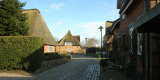
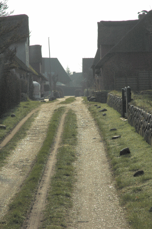
Village on Föhr at the
edge of the geest with road to the marsh
area.
© M. Vollmer |
8. Sources
Author: Matthias Maluck
General literature:
Vollmer, et. al. (eds.) 2001. Landscape and Cultural Heritage in the Wadden Sea Region – Project Report. Wadden Sea Ecosystem No. 12. Common Wadden Sea Secretariat. Wilhelmshaven, Germany.
Innenministerium des Landes Schleswig-Holstein (eds.) 2004. Regionalplan für den Planungsraum V, Amendment File.
Ministerium für Umwelt, Natur und Forsten des Landes Schleswig-Holstein (eds.). Landschaftsrahmenplan für den Planungsraum V. Kiel 2002.
Kunz, H. & Panten, A. 1997. Die Köge Nordfrieslands. Bredstedt.
Bantelmann, Landschaft und Besiedlung Nordfrieslands in vorgeschichtlicher Zeit (Husum 1992)
Bantelmann, A. (ed.) 2000. Das große Nordfrieslandbuch. Bredstedt.
Gemeinsames Wattenmeer Sekretariat (ed.) 2005. Das Wattenmeer. Theiss Verlag Stuttgart.
Beseler, Kunst-Topographie Schleswig-Holstein (Neumünster 1969)
Braun, Strehl (eds.), Langhaus und Winkelbau. Uthlandfriesische Bauformen im 18. und 19. Jahrhundert (Bredstedt 1989)
Vogel, Der nordfriesische Geestrand, die Entwicklung seiner ländlichen Siedlungen und ihrer Flurformen (Bräist/Bredstedt 1996)
Fohrbeck, Schikotanz. Die Region „Uthlande“ Ein Regionales Entwicklungskonzept (unpublished)
Fahrenkrug et. al. Regionales Entwicklungskonzept Nordfriesland (unpublished, 2003)
Maps:
Archaeological monument record of Schleswig-Holstein and gis mapping
Lancewad data base and gis maps
Royal Prussian ordnance survey of 1879
Map of H. du Plat of 1804/05
Map of J. Mejer, 1648
Map of J Meier, 1648, Reconstruction of landscape in 1240
Comments:
Especially tourism needs to take further account of landscape and cultural heritage. Large potential is also in the change of agriculture. Especially set-aside and contract-based nature protection, but also private nature protection needs to be integrated in order to create further attractive offers for cyclists, hikers and riders. Recommendations on county and regional scale often mention sustainable developments and integration of landscape and nature as well as they recommend further improvement of culture and nature related tourism. Measurements for realisation, concrete integration in sector aims and models is, however, totally missing. This proofs that just writing it down can only be the very beginning. Furthermore, information on landscape and cultural assets are very scarce and superficial. Recommendations, like to integrate buildings into landscape, don’t base on substantial definitions. Landscape model still focus mainly on nature aspects and also fail in realising goals into measurements and recommendations integrating cultural assets.
|