|
1. Overview
|
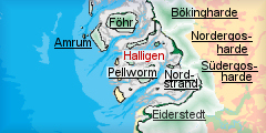
Name: |
Halligen |
|
Delimitation: |
Salt marsh islands,
neighbouring entities Pellworm, Nordstrand, Südergosharde,
Nordergosharde, Bökingharde, Amrum, Föhr |
|
Size: |
The still extant 10
Hallig islands vary from 7 ha (Habel) to 956 ha (Langeness), the
summarized salt marsh area is 2 274 ha, dispersed over a mud flat area
of roughly 20 x 30 km, also comprising the entity of Pellworm. |
|
Location
- map: |
Wadden Sea Area of North
Frisia, Schleswig-Holstein, Germany |
|
Origin of name: |
Frisian name for salt
marsh and, later, salt marsh islands without embankments with early
modern origin, meaning unknown, whereas origin of names of single
islands are known, like Hooge from high land, Langeness from long nose
or Oland from old land |
|
Relationship/similarities with other cultural entities: |
Dwelling mounds on salt
marshes were in use everywhere along the Wadden Sea coast, but
separate, other inhabited salt marsh islands (Ockholm, Galmsbüll,
Fahretoft, etc.) only existed in the Bökingharde and the northern part
of the Nordergosharde |
|
Characteristic elements and
ensembles: |
Remains of medieval settlement in adjacent mud flats |

2. Geology and geography
2.1 General
The Pleistocene basis in the underground had been eroded away by the
transgression of the North Sea since the end of the ice age and was
subsequently topped by layers of sediments and turfpeat. Marsh land and bogs
covered the area in early and high medieval times. A barrier of sand banks
and islands in the west separated this land from the open North Sea. This
protection was gradually destroyed from the 11h century on. Insular salt
marshes occupying large parts of the area were known as Strand from the end
of the 12th century on. The Hallig islands consist of salt marshes which
have formed by continuous sedimentation and erosion through over the
centuries on top of remaining bits of older salt marshes, which have
survived the catastrophic storm surge of 1362. The remains of the moraine
core protrude higher underneath the Hallig and the marsh islands than below
the adjacent mud flats and tidal inlets providing a stable basis. The layers
of turfpeat underneath the medieval marsh surface reached thicknesses from
of several tens of centimetres in the west to several meters in the east.
Most of it was cut away by humans during medieval times. Only the salt marsh
of Nordstrandischmoor has piled on top of remains of the ancient bogs.
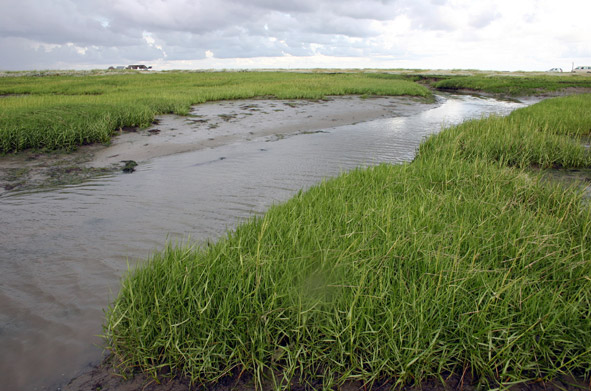
2.2 Present landscape
Today, the large tidal inlets of Norderaue, Süderaue, Norderhever and
Heverstrom together with numerous smaller tidal canals intersect a vast
space of mud flats, spotted by the stains of the partially dry land of the
Hallig islands and the embanked marsh island of Pellworm. The largest of the
tidal inlets cut more than 20m deep into the ground more than 20m deep
whereas the salt marshes stand raise up to 2m high. The landscape of the
Hallig islands is dominated by the dwelling mounds with houses and few
protective trees on top, which can be seen from afar. Smaller tidal inlets
and often artificial canals intersect the surface. Modern, straight and
asphalted roads connect the mounds. Small harbours at the shore side provide
the connection to the main land. Today, Aall of the Hallig islands are today
protected against further erosion by stones enforcements along the edges,
yet still subject to frequent and regular flooding. Dams connect
Nordstrandischmoor, Hamburger Hallig, Oland and Langeness to the main land.
Habel, Südfall, Norderoog are not inhabited anymore and are part of the
Wadden Sea national park. Their surface is still very uneven and much more
intersected by tidal inlets. The newly gained salt marshes, especially at
the western side of Oland, distinguish notably from the irregular old salt
marshes by its regular canals, dividing the new land into square fields
intersected by parallel ditches. The whole of the Hamburger Hallig has a
similar appearance.
 |
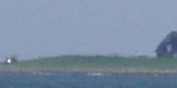
|
Tidal stream with dwelling mound in background on Hamburger Hallig.
© ALSH |
3. Landscape and settlement history
3.1 Prehistoric and Medieval Times
Some finds testify first human settlement in the area for the Young Stone
Age of around 2300 BC, but continuity can only be expected from Viking Age
Times on. Traces of settlement west of Hooge are dated as early as the 8th
century. The North Frisian Wadden Sea of this time consisted of a large
expanse of marshes and bogs, cut off by the direct influence of the North
Sea by sand barriers further west than the modern sand banks. However, aYet,
a temporary intrusion of the sea must have caused the development of salt
turfpeat along a line leading from Hooge along Nordmarsch-Langeness and
Oland into the Bökingharde. Pits as
traces of exploitation of salt
turfpeat can still be seen along this strip in the mud flats. Other
parallel ditches in the mud flats and underneath the Hallig surface display
the common practice of turfpeat cutting in order to reach the underlying
fertile clay. The turfpeat was then disposed of in the ditches. These
structures were intersected into rectangular areas by low embankments
spotted with dwelling mounds for the farms. Other mounds were larger or
combined several single mounds into a village mound. Especially the mud
flats north of Habel bore ample signs of this high medieval landscape. These
dwelling mounds were only raised from the late 12th century on as reaction
of an increasing influence from the open sea as the protective sand barriers
yielded more and more. These settlements oriented along tidal inlets, which
seemed to distribute them rather randomly. It was only then, when the area
of legendary Rungholt south-west of Südfall became inhabited. At this time
the expansive marshland area was already intersected into islands by tidal
inlets, the largest of which was called the Iisland of Strand, covering most
of the area of the Hallig and the marsh islands, while the locations of
others remain unknown.
The first embankments to protect against the rising sea can also be assigned
to the 12th century, proving that the early dwelling mounds in the area were
already protected by dikes, unlike today. When in 1362 the catastrophic
flood of the Grode Mandtränke stroke the area, it destroyed Rungholt and
large parts of the embanked marsh land, leaving behind a multitude of Hallig
islands and remnants of the older marshes.
Subsequently, the salt marshes of the Hallig islands were raised on top of
the destroyed cultivated land by sedimentation through frequent flooding.
Other parts, like the island of so-called Alt-Nordstrand or Strand was were
embanked again. The continuing loss of unprotected land often afforded
mounds to be re-built more inland. Most of the mounds on the Hallig islands
thus virtually moved with a newly heaped mound while the ancestor was left
to the waves. This process can even be tracked today as vestiges of
predecessors of some of the existing mounds still show in the adjacent mud
flats. Land use of the time and till today was has been mostly restricted to
mowing and cattle as well as and sheep breeding due to the recurrent
flooding. However, some small polders for agriculture of probably late
medieval origin, still exist on Hooge and Langeness adjacent to dwelling
mounds like Hanswarft, and are
now largely buried under the clay brought in throughout the centuries. The
land was used as common which had to be divided each spring anew among the
inhabitants in order to make up for the loss of salt marshes during the cold
season and thus remained undivided by ditches.
3.2 Early Modern Times
The storm surge of 1634 marked another important event in the landscape
history of the Wadden Sea area of North Frisia when the old island of
Alt-Nordstrand was lost to the waves and only few remaining bits of the
marshland could be embanked again in the ensuing years. Besides the marsh
islands of Pellworm and Nordstrand, it was a vestige of medieval raised bogs
that survived, heightened by accumulated clay, as Hallig island of
Nordstrandischmoor. The belfry
of the church, which survived the catastrophe, crumbled later, but the
remarkable cemetery with its
horizontal tombstones is still abiding there today. During the following
centuries, the small islands further decreased in size by the constant break
up of salt marshes along the unprotected edges. Further dwelling mounds,
erected on the comparatively high soil along the edges of the Halligen, had
to be abandoned and rebuilt farther inland. The same procedure even applied
to churches, like the one on
Gröde of late 18th century
origin, which is allegedly already the 7th reconstruction. Therefore, the
churches were simple hall constructions without belfriesy, which was were
often added as detached frame still to be seen on
Oland and
Langeness. The farms were
built in the style typical for the region, threathendthreatened by storm
surges, the so-called Uthlande style. Due to the numerous heavy floods, even
in modern times, only few have survived, especially on Langeness, like
Haus Tadsen from the 18th
century hosting a museum today.
The number of Halligen of those times itself was much greater than today.
The Beenshallig, for instance,
south of Gröde, had disappeared by the end of the 19th century.
 |
|
Former Hallig island of Beenshallig south of Gröde at the end of the
19th century and present shoreline for comparison.
© LVermA-SH |
Besides the
decreasing size also the shape of the Hallig islands had changed
considerably. At the end of the 18th century,
Gröde and
Appelland, today unified, were
then two totally separate islands, the latter already uninhabited, but with
a still extant dwelling mound. Two older mounds were visible in the mud
flats west of Neuwarft on
Gröde. Wide tidal canals separated the Halligen of Nordmarsch, Langeness and
Butwehl, which are still extant, even though much narrower. The connection
to the mainland was provideds by boats fastened to small moles at larger
tidal inlets on which’s high banks the mounds were piled-up.
Habitation, as earlier, was only possible on dwelling mounds and fresh
water had to be procured by deep pools dug into the mounds, the Fethinge,
and embanked areas at the foot of the mounds, Scheetels, connected to
the Fethinge. Especially the former have survived modernisation in
comparatively large number, like on the abandoned
Pohnswarft on Hooge, but
also between modern houses as on
Ketelswarft on Langeness,
where also traces of Scheetels remained. Pools protected by ring dikes
provided fresh water even outside the dwelling mounds and are also still
extant on some occasions especially on Hooge.
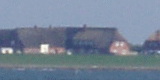
a.jpg) |
|
Large tidal stream and dwelling mounds on Hallig Hooge.
© ALSH |
Farms were connected by
footpaths on the higher banks of tidal canals or the edges of the
islands, which crossed the numerous tidal inlets via movable wooden
bridges. These features have totally disappeared today. A
considerable wealth was gained from the early 17th till the end of the
18th century by some of the inhabitants through seafaring and whaling,
whereas their wivfes had to stay on the islands in order to care for the
animals. Some splendid vestiges like the
Königspesel on Hooge, a
richly ornamented room for special occasions, tell of these times.
Others fell into poverty as the constant loss of land bereft them of
their share of the land, which was not at all equally divided amongst
the islanders. The collection of wild plants and birds eggs used to be,
besides fishing and stock breeding, an important means of subsistence
for many of the inhabitants up into the 20th century.
3.3 Modern Times
Another storm tide marked the beginning of the modern time in the Halligen
area. This so-called Hallig -flood of 1825 destroyed 90% of the old
farmsteads on their mounds, leaving Südfall, where all people died,
uninhabited, except for the short episode of the so–called Hallig duchess in
the early 20th century. It was around that time when the importance of the
slowly vanishing Hallig islands as wave breaker in front of the mainland
marshes received recognition, but it took till the end of the century, when
the area belonged to the new German state, to start with the protection of
the Hallig shores with stones. This measure finally managed to stop the loss
of salt marshes but at the same time brought an end to the characteristic
transitional zone between mud flats and salt marshes, where both had merged
gradually into each other.
Since then the size of the Hallig islands has more or less stayed the same.
The wide mouths of large tidal canals, which cut through the patches of salt
marshes, were blocked by sluices during the ensuing decades, leading to
sedimentation of tidal inlets, some now not more than meandering ditches.
Thus, the small harbours
belonging to each dwelling mound before had to be substituted by common
harbours behind the new sluices, as on Gröde, or in small, protected bays,
as on Oland.
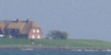
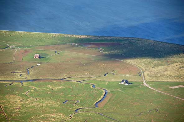 |
|
Hallig island of Nordstrandischmoor, developed on peat of the medieval
island of Strand.
© ALSH |
From around 1900,
Oland and Langeness, later also Hamburger Hallig and Nordstrandischmoor,
became connected to the mainland by dams causeways on which
narrow gauge railways have run
since the 1920ies. This offered better accessibility and has also led to
further accumulation of salt marshes.
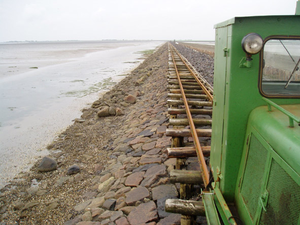 |
|
Narrow gauge railways which connects Oland and Langeness to the
mainland since the 1920ies.
© ALSH |
The secured shoreline also finished a process during which some Hallig
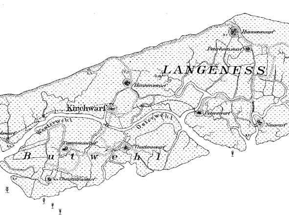
islands had grown together gradually. Langeness, Nordmarsch and Buthwehl,
before separated by rather wide channels, were combined into one large
island, as well as Gröde and the salt marshes of Appelland.
 |
|
.The
division of Langeness into separate islands was still visible at the
end of the 19th century
© LVermA-SH |
The 1930ies also saw an end put to the traditional way of sharing the land
between the inhabitants every year. As the size of the islands didn’t not
decline any morefurther, this seemed unnecessary. Many ditches were dug on
Hooge by massive support of labour under the early Nazi regime in order to
divide the land, whereas on the other islands these structures remained
scarce as the shift to land devisiondivision took place later. Only on Gröde
the traditional land use has been retained till today. Land reclamation
measures around the islands have, at some places as Oland and
Nordstrandischmoor, led to new salt marshes in the west. This land is
characterised by its regular structure, originating in groynes, the parallel
fences and embankments reaching into the mud flats and made in order to
promote sedimentation, as well as the parallel ditches dug into the new salt
marshes to accelerate drainage.
4. Modern development and planning
4.1 Land use
The focus of land use has shifted very much from cattle breeding to nature
and coastal protection in recent decades. All of the small and uninhabited
Hallig islands, like Südfall, Hamburger Hallig and Norderoog are bird
sanctuaries with only an observation ward, inhabited during the warm summer
saison. Only Süderoog is used for organic agriculture, even though it is
also part of the national park.
The decline of local agriculture is mostly due to high costs of transport
and good income gained by tourism. The extensive stock breeding has always
depended largely on animals from the mainland, which are brought to the
Hallig islands only for grazing during the summer. This is still the case,
with different varying ratios of self-owned to external-owned cattle between
the islands. Damages by birds and storm floods to the pastures are being
reimbursed to the farmers. Fishery for self supply is still possible on
limited scale. Land owners also receive money as contractors to nature
protection for pastures left unused.
During the last round about 150 years the importance of the Hallig islands
for coastal protection has increased steadily. They are important as
vanguard for the mainland in order to lessen the impact of storm surges.
Therefore many islanders are at least partially employed by the state for
coastal protection works like maintaining the concrete protection of the
shores and land reclamation measures. Summer dikes around the whole islands
have reduced the number of times the islands are flooded annually, sometimes
e.g. to 2-3 times on Hooge due to its high embankmentduring the year as with
the high embankment around Hooge. Since 1976, the dwelling mounds have been
extended and sourrounded by a ring dike for protection against the
increasing flood level, which has also risen because of large embankment
projects like Beltringharder Koog in front of the mainland marshes.
Traditional highteningheightening of the mounds was not possible anymore
without disassembling the houses. This process hasn’t been finished yet and
the mound of Mittelritt/Lorenzwarft on Hooge is currently under construction.
The unique traces of medieval and early modern settlement in the mud flats,
which have been revealed over the last decades are now about to become
disguised again by increasing sedimentation in these areas.
4.2 Settlement development
The storm surge of 1962 has left many houses, especially on Hooge, in ruins.
They had to be substituted by modern constructions, which have a central,
supporting frame of concrete and a shelter in. the attic. The islands have
received fresh water and power connections with the mainland only in the
years after 1953. Naturally, the space for building is restricted to the
dwelling mounds and cannot be extended. Those buildings, which haven’t not
been substituted by modern ones, are have often been much altered
significantly and made suitableadapted forto the recent purposesrequirements.
Therefore the actual building structure is mostly influenced by tourism and,
still, protection against storm floods. Three small museums exist on
Langeness, while Hooge has two, together with a cinema, which giviprovidesng
an impressions of the storm surges. The focus of tourism differs strongly
from island to island. Hooge is the most touristic of all Hallig islands
with the highest rate of daily visitors, while Langeness, the largest of
these islands, has put more emphasis on long term tourism.
4.3 Industry and energy
Wind power generators are not allowed in this entity. No industry has ever
set foot on the Hallig islands up to now nor is it planned that it will to
do so, in the future.
4.4 Infrastructure
The traffic between the Hallig islands and the mainland is either done
performed by via ferries, mostly from the harbours of Schlüttsiel and
Dagebüll, or by via narrow gauge railways to those islands, that are
connected by a dam. The marine connection to the larger Hallig islands like
Langeness and Hooge is tide independent due to long moles reaching out to
tidal canals, while the other islands can only be reached at high tide. The
railways are only accessible at low tide. New roads had to be built to cope
with the use of cars, now paved and fitted with fixed bridges. These roads
are running straight across the islands, disregarding the traditional
courses on high banks, which often leaves them submerged in the cold seasons
for a longer time.
5. Legal and Spatial Planning Aspects
The Wadden Sea area around the Halligen and all of the uninhabited Halligen
and Süderoog are part of the Wadden Sea national park of Schleswig-Holstein,
which, in principle, aims for a natural landscape without human made aspects.
. The major part of the mud flats around the Hallig islands is
archaeological protection area. The Hallig islands of Hooge, Langeness and
Oland are also focus area for tourism, requiring specific co-ordination of
touristic building measures with the aim to keep still existing free spaces
on the dwelling mounds. Further more, Hamburger Hallig is nature protection
area, Nordstrandischmoor, Gröde, Hooge, Langeneß and Oland are also areas of
international significance for bird protection according to the Ramsar
convention and Natura 2000. Hooge is rated suitable as landscape protection
area. A recent discussion about the extension of the biospheric reservation
of the Wadden Sea to the Hallig islands has even led to a common application
of the islanders for this extension eventually, taking account of the
resistance and reluctance of many inhabitants. A model of the landscape
framework plan for the Hallig islands is focusing strongly on the natural
aspects of landscape, yet calling it cultural landscape.
6. Vulnerabilities
Much of the unique situation of the Hallig islands with their shifting and
soft borders between salt marsh and mud flats, as well as their large,
intersecting tidal inlets and major parts of the traditional culture have
been lost through modernisation and coastal protection, especially during
the last decades. Thus, at the Hanswarft on Hooge, one of the rare
freshwater collection systems, a so-called Scheetels, vanished only recently
due to an extension of the mound. Still in certain danger are elements of
the indigenous local history which are in competition with buildings and
infrastructure for the limited space on the dwelling mounds. This pressure
was largely put up by the increased focus on tourism, which, in itself, has
also changed the landscape with infrastructural measures, especially on
Hooge, the island with the highest rate of daily visitors. These
tourism-oriented actions, even if integrating cultural aspects, are often
not sufficiently co-ordinated with respective experts. Cultural heritage
still has only relatively low priority on the Halligen, contrasting its
importance for tourism. No integrated development and tourism concept thus
exists, also incorporating integrating cultural heritage. An important
attempt in the 1980ties was unfortunately dumped, which included, for
instance, proposals for adapting modern buildings with little effort to
traditional styles. More Increasing daily tourism canould expel visitors
looking for tranquillity. Historic landscape elements within the area of the
national park Wadden Sea may be threatened by extinction by measurements in
order to create a purely natural environment.
7. Potentials
The Hallig islands with their repeatedly flooded salt marshes are still an
area of a unique and impressive cultural landscape, certainly an asset. The
difficult accessibility via water, track or, sometimes, mud flats, turn out
to beis positive for those visitors seeking secluded recreation and
relaxation. Thus, the Hallig islands, especially the smaller ones, have
already a high percentage of regulars. This should naturally lead to more
sustainable, integrated forms of tourism, partially already practised, as
the limit for capacity growth for sustainable tourism is has already been
reached. Respective concepts, also taking account of the cultural historic
assets of the area as part of high quality tourist offers, are therefore
necessary, as a study of 2004 already underlines. The local use of local
products, e.g. in gastronomy, and its commercialisation still bears
potential for growth and can strengthen traditional forms of land use, which
are in return important for the the local picturelocal landscape. The Hallig
foundation was constituted in 1990 in order to promote local cultural
heritage and is therefore important for integrated concepts. The idea of a
political association to co-ordinate local development can further this
process. Besides nature trails, a culture trail can also strongly contribute
to the reception of landscape. An involvement of experts is recommended in
this respect.
8. Sources
Author: Matthias Maluck
General literature:
Vollmer, et. al. (eds.) 2001. Landscape and Cultural Heritage in the Wadden
Sea Region – Project Report. Wadden Sea Ecosystem No. 12. Common Wadden Sea
Secretariat. Wilhelmshaven, Germany.
Innenministerium des Landes Schleswig-Holstein (eds.) 2004. Regionalplan für
den Planungsraum V, Amendment File.
Ministerium für Umwelt, Natur und Forsten des Landes Schleswig-Holstein (eds.)
2002. Landschaftsrahmenplan für den Planungsraum V. Kiel.
Kunz, Panten. Die Köge Nordfrieslands (Bredstedt 1997)
Bantelmann, A, et. al. (ed.). Das große Nordfrieslandbuch (Bredstedt 2000)
Gemeinsames Wattenmeer Sekretariat (ed.) 2005. Das Wattenmeer. Theiss Verlag
Stuttgart.
M. Müller-Wille, B. Higelke, etc. (eds.), Norderhever-Projekt, Offa 66
(Neumünster 1988)
Albert Bantelmann, Rolf Kuschert, Albert Panten, Thomas Steensen. Geschichte
Nordfrieslands. (Heide 1996)
Albert Bantelmann: Nordfriesland in vorgeschichtlicher Zeit. (Bräist/Bredstedt
2003))
Chamber of agriculture Schleswig-Holstein, Machbarkeitsstudie zur
Entwicklung der Halliglandwirtschaft für die Halligen Gröde, Hooge,
Langeneß, Nordstrandischmoor und Oland (2002)
Katrin Augsburg,B. Eisenstein, Max Triphaus. Weiterentwicklung der
touristischen Organisationsstrukturen der Nordfriesischen Halligen (Study
ordered by Stiftung Nordfriesische Halligen) (2004)
U. Harth. Der Untergang der Halligen (Hamburg 1992)
M. Petersen. Die Halligen (Neumünster 1981)
Maps:
Archaeological monument record of Schleswig-Holstein and gis mapping
Lancewad data base and gis maps
Royal Prussian ordnance survey of 1879
|