|
1. Overview
|
Name: |
Pellworm |
|
Delimitation: |
Island, neighbouring entities Nordstrand, Hallig islands, Eiderstedt |
|
Size: |
37 km², 6 km from south to north, 7 km from east to west |
|
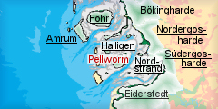
Location
- map: |
Wadden Sea Area of North Frisia, Schleswig-Holstein, Germany |
|
Origin of name: |
The name is derived from a former administrative unit, a so called Harde, of the disappeared island of Strand. |
|
Relationship/similarities with other cultural entities: |
Pellworm was connected with Nordstrand till Early Modern Times, is likewise a marsh island; some modern polders like Nordergosharde, Dithmarschen; farm buildings like Nordstrand, North Frisia; duck decoys like Netherlands, Föhr, Nordstrand |
|
Characteristic elements and
ensembles: |
Early medieval, single, dispersed dwelling mounds and vestiges of settlements on level ground, parts of medieval dikes, remains of medieval settlement in adjacent mud flats, early modern polders, dikes built up in early modern and Modern Times, farmhouses of that time, ponds and other water bodies as vestiges from dike breeches |

2. Geology and geography
2.1 General
The marsh island of Pellworm is situated in the Wadden Sea of North Frisia in an area of elevated Pleistocene sediment providing a stable basis for the layers of mud and of turf which has accumulated here in the millennia of rising sea level after the end of the last ice age. Its oldest marsh areas are remnants of the medieval island of Strand and, later, Alt-Nordstrand, at a time when large areas of the modern mud flats were covered by salt marshes and bogs, intersected by tidal inlets and protected from the open North Sea by barrier sandbanks in the west. The salt marshes of Pellworm had been frequently flooded and severely altered and destroyed in two disastrous floods in the past and only after the second in 1634 it could gain its modern aspect of embanked polders encircled by mud flats that still bear traces of medieval settlement.
2.2 Present landscape
Pellworm is surrounded by the Hallig islands, of which the majority is spaced north of the island. The deep tidal inlet of Norderhever, which cut the medieval island of Strand gradually into half, separates Pellworm from the other vestiges of that time, Nordstrand and Nordstrandischmoor in the east, which are today connected to the mainland marshes around the county town of Husum and the polders of the Südergosharde. The peninsula of Eiderstedt delimits the Wadden Sea area of North Frisia south of Pellworm.
The marshes of Pellworm are hardly above sea level. They have very little relief and are structured by winding roads along the courses of or on old dikes and irregular drainage canals. Fields are divided by rectilinear, parallel ditches into narrow strips in the south and east, orienting towards the linear settlements on dikes, and larger, rectilinear enclosures with single farmsteads in the latest polders in the north-east. Fields in the old polders in the centre and the north-west are irregular, small scale enclosures, intersected by sinuous ditches. The marshland is mostly used as pasture and, to a lesser degree, for farming. Settlements are arranged in rows on old sea walls, whereas as single farmsteads on mounds are dispersed within the polders. Tammensiel, together with Ostersiel, is the only village where buildings have spread notably into the marshland, especially some small modern residential areas with detached houses. Houses are low and often built in traditional style. A few two to three storey buildings are situated around the harbour. Deserted mounds can frequently be observed within the fields. Only few trees have been planted along some roads and around houses as windbreak. Taller constructions are only the churches, an old windmill and a few wind power generators.
3. Landscape and settlement history
3.1 Prehistoric and Medieval Times
The western and central polders are remains of marshes that have survived the devastating waves of the flood of 1634 and were embanked again shortly afterwards in order to secure what had been left. Large parts of the former marshes had been inundated and eroded subsequently, revealing even older, high medieval traces, like structures of parallel ditches, which are relics of measures of soil melioration north of the modern polder of Bupheverkoog. The
earliest settlements of early medieval origin were still on level ground, reflecting the low water level at the time, and can be dated back to the 9th century. They can sometimes be tracked as very low mounds, e.g. east of the new church. Since the end of the 12th century it became necessary to raise dwelling mounds, like the
Thiessenwarft, as protection from the rising sea. The rather late date emphasises the protection by a closed line of sandbanks in the west, which had finally been eroded by the North Sea at the time, leading to a significantly increased maritime influence in the area. The population rose around the same time, probably due to new Frisian settlers from the area of the modern Netherlands, which were proficient in building sea walls. Today dwelling mounds still spawn all over the old polders in what seems a random distribution, but which is at least partially oriented along former tidal inlets, the typical settlement pattern of early occupation. Some of these inlets have survived till today, mostly as irregular ditches and field borders. The
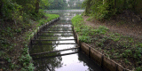
Waldhusener Tief, a still extensive water body in the Große Koog, is what has been left of a large tidal inlet, which forced its way in the late middle ages.
a_klein.JPG) |
|
The Waldhusener Tief, an extensive water body in the Große Koog, is
left of dike breech in the late middle ages.
© ALSH |
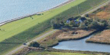
Many of the mounds were erected after the flood of 1362, which killed thousands of people, devastated large areas of the marshes and drowned the famous trade settlement of Rungholt east of modern Pellworm. The whole of the medieval marshes in the area was lowered by cutting turf, which formed a thin layer beneath the surface of the marsh soil. Salt could not be extracted from the turf underneath Pellworm, while it contributed to considerable wealth in the area of the Halligen. The only building of the time that has survived is the
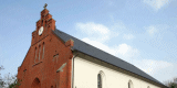
Alte Kirche, a Romanesque church from the 13th or 14th century with its remarkable, ruined belfry, situated close behind the modern sea dike in the Alter Koog and used as landmark for ships till Modern Times.
a.jpg) |
|
The Alte Kirche in the Alter Koog with a pool from clay extraction in
front.
© ALSH |
The typical irregular, sinuous field system of the time, when the marshland was mostly used as common for grazing cattle, is still easy to discern and has suffered comparatively small changes throughout the time. Even some
relics of dikes from before 1634 can be detected near the school or in Tüterland, were the bank is accompanied by a pit, dug in order to obtain material for dike building.
3.2 Early Modern Times
Vestiges of late medieval and early modern settlement, originating in the time after the big flood of 1362 and washed away again in 1634, can hardly be observed in the surrounding mud flats as these higher layers of marshland were mostly eroded. A new and quick embankment of some areas was fostered by Dutch support. A farmhouse, built by the end of the 16th century, survived at
Nordermitteldeich, as well as the
Neue Kirche, erected in 1528. Stock breeding was again the predominant land use, but also farming was practised.
a.jpg) |
|
The Neue Kirche, erected in 1528, survived the storm tide of 1634.
© ALSH |
The cultivation of rape was introduced in the late 17th century. The harbour was at the time located near Tilli until the marshland there was reclaimed. These new polders, like the
Ütermarkerkoog, were regained in quick succession south and east of the
Großer Norderkoog during the 17th century, almost achieving the modern appearance of Pellworm by 1700. As new clay had meanwhile accumulated on the destroyed marshes, older structures were overlaid by more modern and regular field systems, which were still far from the systematic appearance of the imposed polders
elsewhere.
Only few new single farmsteads of rich farmers were built in these polders on mounds, usually surrounded by ditches, while other islanders erected their houses in rows on older embankments, like at
Südermitteldeich,
Ostertilli and
Schardeich, which now provided save, elevated ground. The vicarage of the new church dates back to the beginning of the 18th century, whereas a dwelling house on
Südermitteldeich and a four-sided farmstead at
Moordamm are even older. Traditional fishery, as an additional form of subsistence, is still represented by some old fishermen’s houses like at
Klostermitteldeich or
Südermitteldeich which are from the 18th and even 17th century. Most modern roads stem from this time either as road built on top of dikes or as linking paths between mounds, like
Alte-Kirchs-Chaussee and
Tüterland. Some even remained gravel paths like the connection between
Westerschütting and
Südermitteldeich and the footpath between
Seegarden and the
Neue Kirche. Numerous pools tell of dike breeches after 1634, like at
Südermitteldeich from before 1770 or at
Westerkoog dated to 1825.
 |
|
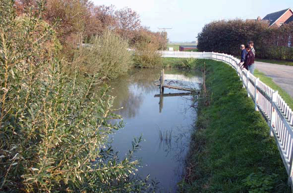
A well kept example of a Fething, a pool for fresh water for animals
on a dwelling mound, on Tammwarft.
© ALSH |
Sea walls even had to be built anew several times behind the old, destroyed dike line. Agriculture has therefore suffered from the frequent inundations which spoiled the harvest and the fresh water and also promoted diseases and enhanced the mortality above the birth-rate. Only constant immigration of people from the mainland could make up for the loss. The deplorable condition of the sea walls was mostly owed to the system of private maintenance, in which the adjacent land owners themselves had to care for the preservation. This was substituted by the end of the 18th century by a system of communal maintenance, which improved the situation, but made it nevertheless again necessary to put back the dike line in the north and west due to severe damages after a storm surge.
3.3 Modern Times
In spite of the fertile soil, many inhabitants were impoverished by the heavy costs of dike maintenance and were forced to sell the land to their creditors at the beginning of the 19th century. The situation improved only after the state of Denmark took over the maintenance of the sea walls in order to keep the island as embanked breakwater in front of the mainland instead of turning it into a Hallig island. The dikes were enforced by berms of stone at the basis of those sea dikes without protecting salt marshes in front. Numerous, water-filled pits, dug by the extraction of clay, can still be seen near the
Alte Kirche,
Hooger Fähre or in the north-west and north-east, behind the outer bank. Dutch windmill technique introduced modern methods of milling also into Pellworm, as a couple of extant buildings exemplify, ruined or in use, like the ones at
Nordermühle or Ostertilli. Most of the still existing, traditional farmhouses stem from the 19th century, elongated, thatched brick buildings with entrance and gables at the side, often surrounded by ditches. The drainage was improved by a new sluice in the first half of the 20th century and eventually by the pumping station at
Tammensiel. Larger water bodies, mostly former dike breeches, still serve as reservoir for the inland water, like the
Waldhusener Tief for the northern polders and the
Süderkoogtief for the south.
a.jpg) |
|
A duck decoy for large-scale bird catching, built around 1900.
© ALSH |
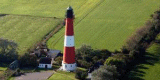
The impressive
lighthouse and a
duck decoy for large-scale bird catching, which are, in North Frisia, only found on the islands, were built around 1900.
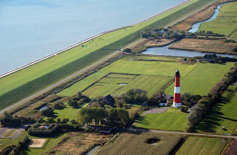 |
|
The lighthouse and and former dike breech of Süderkoogtief in the
background, nowadays reservoir for drainage.
© ALSH |
Many residential houses in traditional, elongated brick-style of the late 19th and early 20th century are still in use. The embankment of the
Bupheverkoog during the time of the national socialists was the first and last new polder after over 200 years and, contrasting the older polders by its strictly geometrical, planned appearance, was mainly designed as outset for a dam, intended to connect the island to the mainland. Many inhabitants left Pellworm during the 19th century in order to emigrate, especially to America. While till the 1970ies the major part of agricultural subsistence was livestock farming, cultivation became more common, with a recently increasing rate of organic farming. Together with the land consolidation of the 60ties this led to a considerable change of field relief and scale enlargement, however, much of the irregular field system is still
intact.
4. Modern development and planning
4.1 Land use
Agriculture is still an important economic factor, in comparison to the other tourist islands. Development will, however, lead to the enlargement of ever fewer farms and additional tourist offers of farmers. The tendency is therefore strong for set-aside of agricultural land, for contract based nature protection and for more quality production like organic farming. As demand increases for renewable energy, farmers also look for possibilities to cultivate energy crops. The island already has a high level of about 10% of organic agriculture which usually disturbs existing landscape structures to a small degree or even helps preserving them. Some areas, like the old dike breech of Waldhusener Tief, are designated for nature protection.
4.2 Settlement development
The island is focus area for tourism, which is nowadays the major source of income for the island. The actualisation of the regional plan therefore restricts further assignment of new areas for houses and camp grounds. The few houses of Tammensiel and Ostersiel have developed since the 1960ies into a central village with a residential area in the north of Tammensiel and a spa in Ostersiel, reflecting the increasing importance of tourism. Although the number of inhabitants has almost cut in half since the 19th century and a large number of dwelling mounds lie now deserted, many new houses were built on former sea dikes and along the roads.
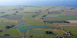
4.3 Industry and energy
Only a few wind power generators were erected in the north-east and are not likely to extend beyond the actual confines, due to restrictions by regional planning. However, the island has one of the largest power plants combining solar and wind power.
a.jpg) |
|
Power plants combining solar and wind power within remains of medieval
fieldscape.
© ALSH |
4.4 Infrastructure
The connection to the mainland at Strucklahnungshörn on Nordstrand is provided by the harbour of Tammensiel. In 1992 the old sluice harbour was supplemented by a long mole reaching out to the Norderhever in order to provide a tide independent access. Roads are narrow and need to be used by cars, cyclists and hikers together. Few specific tracks solely for cyclists and hikers exist.
5. Legal and Spatial Planning Aspects
The island fulfils the requirements for a landscape protection area. It is also rated as structurally rich landscape and is, as focus area for tourism, restricted concerning new structures and buildings connected with tourism. The mud flats are archaeological protection area. Nature protection aims at further integrating agriculture and promoting extensive stock breeding and contract based nature protection in the old polders. Furthermore, it is suggested to raise the number of so-called typical landscape elements and to integrate existing elements into the network of biotopes and protection areas, like the Waldhusener Tief. The landscape plan supports the integration of historic settlement structures into planning. The tourism concept for North Frisia promotes a sustainable development in this sector. An improvement of landscape related tourism together with riding, cycling and hiking is suggested by landscape planning.
6. Vulnerabilities
No special areas are designated as landscape protection areas or as suitable for status. Tourism is only to a very limited degree taking advantage of landscape and cultural
assets.
A dam connecting the island to the mainland would invariable influence the unique island situation. Planned new development areas at Bupheverweg and Seegarden are not necessarily coherent with the island’s typical settlement structure. A further deepening of the waterway between Pellworm and Nordstrand is liable to destroy valuable landscape structures in the mud flats and may endanger the outer sea wall without foreland by the widening of Norderhever. The decreasing number of inhabitants could support methods of subsistence which are not sustainable, e.g. further industrialisation of agriculture, daily tourism, more tourism facilities.
7. Potentials
Much of the medieval and early modern settlement and field structure has remained rather unchanged. Many modern buildings orient at existing structures. Most of the actual roads already existed in the 19th century and even parts of medieval dikes are visible. Especially remarkable are the vestiges of a submerged landscape in the mud flats. A village renovation program has recently helped to bring back much of the traditional appearance of old houses. The island is appointed as spa which supports a more constant and long-term tourism all year round. Further organic agriculture would support development and use of historic landscape. A combination with farm holidays could produce synergies. Marketing and local use of local quality products strengthen landscape compatible forms of agriculture and local subsistence. Further decentralisation of tourist facilities, reduction of daily tourism and caravans in favour of family oriented, long-term stays and offers for experiencing landscape and cultural heritage, as recommended by the actual landscape plan, uses and supports landscape characteristics. Rebuilding former outer dikes as a second line for coastal protection could also further emphasise historic landscape characteristics. They are also best suited for strengthening the local image for marketing purposes. Integration of cultural and landscape issues in maps and recommendations for routes and a network of revived historic paths exclusively for walking, hiking and riding can reach visitors not genuinely interested in these aspects.
8. Sources
Author: Matthias Maluck
General literature:
Vollmer, et. al. (eds.) 2001. Landscape and Cultural Heritage in the Wadden Sea Region – Project Report. Wadden Sea Ecosystem No. 12. Common Wadden Sea Secretariat. Wilhelmshaven, Germany.
Innenministerium des Landes Schleswig-Holstein (eds.) 2004. Regionalplan für den Planungsraum V, Amendment File.
Ministerium für Umwelt, Natur und Forsten des Landes Schleswig-Holstein (eds.). Landschaftsrahmenplan für den Planungsraum V. Kiel 2002.
Kunz, H. & Panten, A. 1997. Die Köge Nordfrieslands. Bredstedt.
Bantelmann, Landschaft und Besiedlung Nordfrieslands in vorgeschichtlicher Zeit (Husum 1992)
Bantelmann, A. (ed.) 2000. Das große Nordfrieslandbuch. Bredstedt.
Gemeinsames Wattenmeer Sekretariat (ed.) 2005. Das Wattenmeer. Theiss Verlag Stuttgart.
Beseler, Kunst-Topographie Schleswig-Holstein (Neumünster 1969)
Braun, Strehl (eds.), Langhaus und Winkelbau. Uthlandfriesische Bauformen im 18. und 19. Jahrhundert (Bredstedt 1989)
Vogel, Der nordfriesische Geestrand, die Entwicklung seiner ländlichen Siedlungen und ihrer Flurformen (Bräist/Bredstedt 1996)
Fohrbeck, Schikotanz. Die Region „Uthlande“ Ein Regionales Entwicklungskonzept (unpublished)
Fahrenkrug et. al. Regionales Entwicklungskonzept Nordfriesland (unpublished, 2003)
Maps:
Archaeological monument record of Schleswig-Holstein and gis mapping
Lancewad data base and gis maps
Royal Prussian ordnance survey of 1879
Map of H. du Plat of 1804/05
|