|
1. Overview
|
Name: |
Süderdithmarschen |
|
Delimitation: |
Marshland at the Wadden Sea coast of Schleswig-Holstein, river of Elbe in the south and Kiel Canal as border line in the south-east, Meldorf bight in the north, which separates the two parts of Norderdithmarschen and Süderdithmarschen, mainland moraines and dunes in the east, bordered by entity of Kremper Marsch and Wilster Marsch and the moraine Geest, dune ridges and bogs in the east |
|
Size: |
|
|
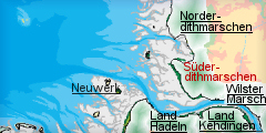
Location
- map: |
Marshes of county of Dithmarschen, Schleswig-Holstein, Germany |
|
Origin of name: |
The name is derived from the Saxonian name Thiatmaresgaho from around 800, which can be rendered as ‘land of the large bogs/waters’. |
|
Relationship/similarities with other cultural entities: |
Structures of wetland colonisation like Kremper and Wister Marsch and the Netherlands. |
|
Characteristic elements and
ensembles: |
Rows of medieval dwelling mounds with adjacent elongated strips of land, intersected by parallel drainage ditches
(Marschhufendöfer), irregular, medieval dike lines with dike mounds and canals, |

2. Geology and geography
2.1 General
The moraines of the mainland in the east, called Geest, which stand up to 40 m high between St. Michaelisdonn and Burg, are bordered by a north-south line of sand dunes of an early coastline before the marshland accumulated in the west in the last centuries before Christ. The marshland area in the west and south-west of the mainland cliff is divided into parallel zones of former boggy, low land adjacent to the line of dunes, higher ancient marshes and high, young marshes, embanked only since Early Modern Timess in the west.
2.2 Present landscape
The marshes of Süderdithmarschen have very little relief and are structured by winding lines of coast parallel medieval and early modern dikes, roughly north-south and east-west running roads and drainage canals. The partly forested Geest forms a significant limit to the mostly treeless, level marshes. Fields in the old marshes east of Marne are mostly divided by long and parallel ditches, orienting towards lines of farmsteads built on top of medieval dikes, and subsequent heavy boundary loss into rectangular, often irregular enclosures. The fieldscape in the western marshes is characterised by more square and large scale fields oriented along a system of perpendicular roads within the polders. Former tidal inlets have only survived in few places and are visible as drainage canals with sinuous courses. Trees are only planted along roads and around settlements and limit an unrestricted view across the marshes significantly. Tall, vertical constructions are churches, few buildings in the villages, power lines and wind power stations with up to 100m height.
3. Landscape and settlement history
3.1 Prehistoric and Medieval Times
The first settlements on the edge of the moraine mainland can be traced back to the late Stone Age demonstrated by megalithic tombs. The earliest traces of settlement on the marshes can be detected in early roman time by two long rows of low mounds parallel to the coast or on the high marsh alongside tidal inlets like
Eddelak. Because of renewed rise of the sea level these settlements, like
Süderbusenwurt, had to be abandoned by the end of the 3rd century AD. But as the marshes fell dry again new, Saxon settlers started to erect new farms on top of the earlier ones since the middle of the 7th century. Large mounds on the high banks of tidal inlets in the old marshes provided enough space for villages like
Lütjenbüttel. The
Bökelnburg in Burg is a circular embankment on the very fringe of the high Geest
designed as fortification for the northern part of northern part of
Dithmarschen in the 9th century, when it was part of the empire of Charles
the Great, and hosting a cemetery today.
a.jpg) |
|
The Bökelnburg in Burg, a circular embankment on the very fringe of
the high Geest from the 9th century AD.
© ALSH |
The old marshes had been embanked with a long dike line parallel to the coast probably from the 12th century on, thus skipping the creation of small, circular polders known from Eiderstedt or Northern Frisia and protecting earlier village mounds like
Marne,
Darenwurth,
Trennewurth and
Busenwurth. Other remains of possible medieval sea walls, like the
Donndiek near
Averlak, indicate even earlier embankments. The bogs of the so-called Sietland between the moraine edge and the fertile old marshland were afterwards drained and settled by the 15th century by two long rows of dwelling mounds and, in order to protect against the inland water, using the same patterns and locations as known from early Roman Times. The mounds of villages like
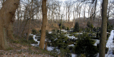
Barlt are directly connected with typical, parallel field strips, separated by ditches (Marschhufendörfer). The co-axial and rectilinear structures have still survived around Barlt yet with a considerable boundary loss.
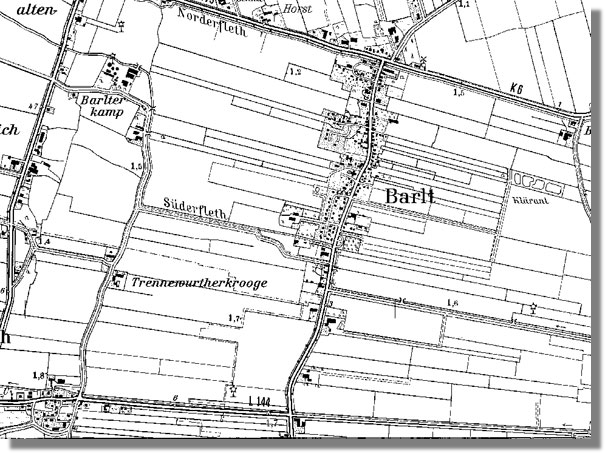 |
|
Mounds of villages of Barlt, directly connected with typical, parallel
field strips, separated by ditches (Marschhufendörfer).
© LVermA-SH |
Fishery was part of their subsistence till new polders pushed the coastline further west. Since the embankment of the marshes agriculture became possible. Fields were privately owned while pastures were used as commons, mostly situated along roads, in low, wet areas and in front of the outer dikes. The representative gothic church of
St. Johannes in Meldorf was erected in the last half of the 13th century, although the first church in Dithmarschen was probably built even before 826. It is still the most important and largest church at the west coast of Schleswig-Holstein. The church was centre of one of the first parishes, which were only constituted around the time.
Meldorf, situated on the fringe of the Pleistocene moraines and central village of medieval Dithmarschen, gained municipal law as first settlement in the area and hosted the only monastery in Süderdithmarschen with remains at the modern
Klosterhof. Ample other historic, bourgeois buildings, like the vicarage of 1601, enrich the picture of the town till today. During the late Middle Ages, Dithmarschen achieved growing independency from extraterritorial powers like the archbishop of Bremen by accumulating more and more privileges, especially for the leading families.
3.2 Early Modern Times
The division of Dithmarschen into the two so-called landscapes of Norderdithmarschen and Süderdithmarschen was manifested in 1559, after the end of a short period of total independency as farmer’s republic. Süderdithmarschen, the area south of Heide was assigned to the King of Denmark. A monument, reminding of a famous local victory for independence against Danish and German troops in 1500, can be visited in Dehling.
Only few new polders, hardly more than narrow strips parallel to the old sea dike like the Hafenkoog in front of Marne, but still embanked as cooperative task of the inhabitants of the adjacent marshes, shifted the medieval dike line in the 16th and 17th century a little further west. While the marshes in the west suffered little from the heavy storm floods of Early Modern Timess the area around modern Brunsbüttel, which was much more under pressure from the shifting course of the Elbe River, had to endure a substantial loss of land in the 16th and 17th century.
Süderdithmarschen gained considerable wealth by cultivating wheat on the fertile marsh soil in the 15th and 16th century. Dairy farming was introduced on a larger scale in the 16th century. The oldest means of subsistence was still traditional stock breeding, which was then mostly confined to salt marshes in front of the outer sea walls, were cropping was impossible. So-called Bargscheunen, barns built around four central posts, are still typical for the area. The genuine Dwer houses were derived from earlier, Saxon bay houses and more frequently in use in the area from the 16th to the 19th century. New salt marshes were at the time only reclaimed by the King of Denmark as new master of Süderdithmarschen. The
Kronprinzenkoog, however, remained the only larger polder that was imposed at the end of the 18th century by the King of Denmark and then sold to east Frisian settlers who introduced the farm house type of the Gulfhaus into the southern part of Dithmarschen.
a.jpg) |
|
Sea defence of the Kronprinzenkoog, the only larger polder that was
reclaimed at the end of the 18th century.
© ALSH |
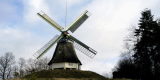
One of the handful of Dutch windmills of that time, which has survived, can be visited in St.
Michaelisdonn-Hopen.
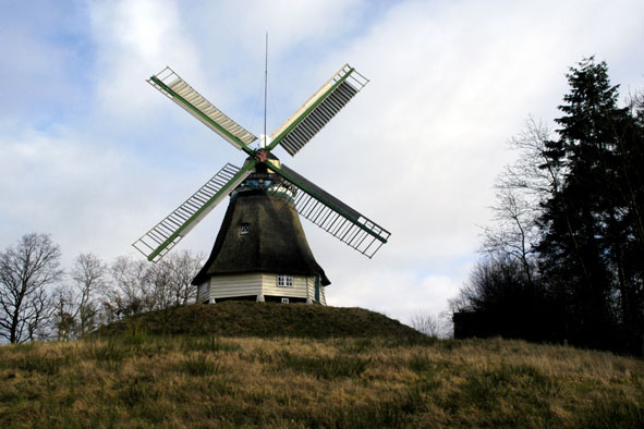 |
|
One of the few Dutch style windmills surviving in St.
Michaelisdonn-Hopen.
© ALSH |
3.3 Modern Times
Unlike the north of Dithmarschen the embanked marshes in the south started to project substantially further and further into the Wadden Sea only from the 18th century, beginning with the large
Kronprinzenkoog, and it was not before the enclosure of the
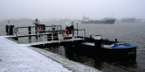
Friedrichskoog on the sand bank of Dieksand in 1854 when it reaches its modern extension to the West, which at that time projected long into the surrounding mud flats. A ring dike pool is still extant in the polder as well as the harbour which was constructed at the end of a tidal inlet with an 80m long mole in order to provide tide independent accessibility. The economic boom after the war of 1871 and the proclamation of the Deutsches Reich left its visible marks also in Süderdithmarschen, altering the agriculture to more industrialized structure with larger farms and more representative buildings in a style typical for the time in Germany. An example is the town hall of Marne, built in 1914/15 in a neo-baroque style. The most remarkable monument of this time in the area is the impressive
Kiel Canal to connect North and Baltic Sea built in 1895 between Kiel-Holtenau and the polder of Brunsbütteler Koog, of which the first floodgate still exists. The town of
Brunsbüttel developed especially in the succeeding years, as did Marne. In 1948 Brunsbüttel was given town rights and today it is the urban centre of Süderdithmarschen and the largest industrial agglomeration along the Wadden Sea coast of Schleswig-Holstein with chemical and petrol industry and even an atomic power plant.
a.jpg) |
|
The Kiel Canal in Brunsbüttel.
© ALSH |
Massive financial support from the government of the new state of Schleswig-Holstein from the 1950ies to the 1970ies promoted this development. One of the last embankment projects was the
Dieksanderkoog, built in 1933-35 as Adolf-Hiltler-Koog. It still displays the typical layout of farms and land at the time. The buildings cite the traditional Frisian house type of the Haubarg with the Nordlandhalle, as most renowned example. Being ahead of its time the first wind power generator of 1926 can still be seen in
Süderwisch.
The change of the coastline and the creation of new polders ended with the straightening of the dike line by the embankment of the extensive southern
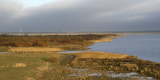
Speicherkoog in the Meldorf bight for coastal protection in the late 20th century, which is mostly used as water reserve, nature sanctuary and for military tests.
a.jpg) |
|
The Speicherkoog in the Meldorf bight, embanked for coastal protection
in the late 20th century and mostly used as water reserve
and nature sanctuary.
© ALSH |
The island of
Trischen in the Wadden Sea west of Süderdithmarschen is scarcely more than a large sand dune with a small marshland area in the east, which was embanked in the 1920ies for a short time before the dunes moved across the polder and left its vestiges in the mud flats.
4. Modern development and planning
4.1 Land use
Agriculture has a strong economical weight. It is rather competitive due to intensive cultivation, specialisation in vegetables, and good quality of soil. More than half of all vegetable in Schleswig-Holstein are produced here. The still existing shrimp fishery based in the harbour of Friedrichskoog works traditionally and therefore on a sustainable basis. Marne has fish-processing industries. Besides the mud flat area and the large polder of Speicherkoog only few areas, especially along the Pleistocene edge, are under nature protection or are of specific importance for nature. Aims of nature protection are pointing towards more extensively used pasturages in small-scale structured areas, which only exist to a small extend in the area. Few dike reinforcement measures are envisaged.
4.2 Settlement development
Süderdithmarschen as mostly underdeveloped rural area is close to the urban area of Hamburg with around two million people and part of its metropolitan region with around four million inhabitants. Brunsbüttel is the urban centre while the town of Marne has central functions, both with modern residential areas. Developing areas will further focus around the towns with their function as centres of regional development, but are less likely to increase strongly as population is expected to decrease in the long term. Tourism is focused in Friedrichskoog and the spa provides for a basic amount of long-term tourists all year long.
4.3 Industry and energy
Brunsbüttel is one of the major industrial areas of Schleswig-Holstein with chemical and petrochemical industry and with a nuclear power plant. Wind energy industry is also of growing importance for the town. Wind power generators are mainly dispersed in small groups in the modern polders and are subject to further upgrading within their confines. Oil is produced in the mud flats with an oil rig and in Dieksanderkoog.
4.4 Infrastructure
Bypasses for national roads are planned for Marne. A net of cycle routes is planned where unpaved agricultural roads can be integrated. The industrial harbour of Brunsbüttel is of trans-regional importance and the Kiel Canal is the waterway with the world’s highest volume of traffic. Railways connect Marne and Brunsbüttel to Heide and Meldorf. The promotion and extension of public transport is planned.
5. Legal and Spatial Planning Aspects
The landscape framework plan characterises the landscape on a general basis and lists, not comprehensively, important landscape elements like settlement structures. Focus areas for nature protection are solely at the edge of the area, whereas the old marshes are mapped as historic landscape and areas of historic fieldscape are around Elpersbüttel and Barlt. Cultural landscape has only minor importance in landscape models of the framework plan but goals of development take account of structurally diverse landscapes, which are also mapped. Recommendations for protection of historic landscape include nature protection instruments, integration into spatial planning on municipal level and promotion of extensive stock breeding. Furthermore, it is suggested to raise the number of so-called typical landscape elements and to integrate existing elements into the network of biotopes and protection areas. Regional planning confirms the high potential of cultural heritage as unique selling proposition in connection with tourist mission statements. However, except for a list of characteristic landscape elements, cultural heritage issues are not an integrated part of the regional plan. The coast line, the canal and parts of the verge between Geest and marshland are areas of specific interest for tourism with very restricted possibilities for new development areas.
6. Vulnerabilities
Most traditional farmhouses have been modernized with materials not genuine or have disappeared. Modern farm buildings strongly affect older ensembles of farm buildings. Frequent parks of wind turbines are highly visible from afar and diminish impression of wide landscape. Further intensification of agriculture can threaten the remains of historic field structures. Especially the modern polders have a low density of landscape elements, which make them hard to promote for tourism. Modernisation of the harbour of Friedrichskoog for event tourism instead of emphasising existing assets can diminish its historic value.
7. Potentials
Some historical structures especially lines of mounds, village mounds and the medieval dike line are still visible or even strongly influencing the appearance of today’s landscape. Typical village types, polders and field systems are rated worth protecting by the regional plan. Guiding principles for spatial planning include aspects by which landscape and cultural heritage can be promoted and utilised, like strengthening of regional identity or sustainable tourism. Further development of long term and recreational tourism can increase the economic importance of existing historical landscape features and environments.
8. Sources
Literature:
Vollmer, et. al. (eds.) 2001. Landscape and Cultural Heritage in the Wadden Sea Region – Project Report. Wadden Sea Ecosystem No. 12. Common Wadden Sea Secretariat. Wilhelmshaven, Germany.
D. Meier, Landschaftsentwicklung und Siedlungsgeschichte des Eiderstedter und Dithmarscher Küstengebietes als Teilregionen des Nordseeküstenraumes, 1999
M. Gietzelt (ed.), Geschichte Dithmarschens, Heide 2000
Ministerium für Umwelt, Naturschutz und Landwirtschaft des Landes Schleswig-Holstein (eds.). Landschaftsrahmenplan für den Planungsraum IV – Kreise Dithmarschen und Steinburg Amendment File (Kiel 2005)
Innenministerium des Landes Schleswig-Holstein (eds.). Regionalplan für den Planungsraum V, Amendment File (Kiel 1998).
V. Arnold, U. Drenkhahn, D. Meier (eds.). Frühe Siedler an der Küste. Küstenarchäologie in Dithmarschen und Steinburg (Heide 1991)
Landesamt für Denkmalpflege S-H (eds.), Kunst-Topographie Schleswig-Holstein (Neumünster 1969)
Monika Waluga, Heinz Walter Kierchhoff. Regionales Entwicklungskonzept Kreis Dithmarschen. Endbericht. Bremen 2001 unpublished
Maps:
Archaeological monument record of Schleswig-Holstein and gis mapping
Lancewad data base and gis maps
Royal Prussian ordnance survey of 1879
Topographisch Militärische Charte des Herzogtums Holstein (1789-1796)
Map of Dithmarschen from Johannes Mejer of 1651
Comment:
Agriculture is very strong in Dithmarschen, especially in post-medieval polder, which have the best soil quality. Here, industrial agriculture and wind generator farms are less harmful to historic structures or landscape aspects as in most of the medieval marshes or some modern polders like Barlter Sommerkoog or Friedrichgabekoog. Extensive stock breeding and also measures in the context of the water framework directive should therefore focus to these areas. It is important to adhere diligently to original historic structures instead of creating new ones in these areas. Tourism is also centred in the modern polders in the west, where landscape assets are much harder to emphasise. The old marsh areas in the hinterland could fill that gap and offer attractive routes for cycling, walking and recreation and thus attract more daily guests.
|