|
1. Overview
|
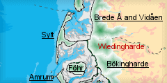
Name: |
Wiedingharde |
|
Delimitation: |
Encompassed by the Karrharde on the Pleistocene Geest around Humtrup and Uphusum in the east, the marshland area of the Bökingharde in the south and the Wadden Sea with the island of Sylt in the west. |
|
Size: |
Ca. 13 km from south to north, ca. 15 km from east to west |
|
Location
- map: |
Situated at the northernmost tip of the marshland area of North Frisia, bordering the Danish Tönder marsh, Schleswig-Holstein, Germany |
|
Origin of name: |
The name is derived from Widhing, the inhabitants along the Widau River, and is handed down since the 17th century when it replaced the former denomination as Horsbüllsharde. |
|
Relationship/similarities with other cultural entities: |
Single farm mounds and village mounds like Pellworm, Dithmarschen, rows of mounds like Föhr, Nordstrand, modern, geometrical planned polders like Bökingharde, Nordergosharde, Süderdithmarschen, medieval dikes, nature reserve polder like Bökingharde, Nordergosharde, Südergosharde, Nordstrand, Dithmarschen, farm buildings like other entities of North Frisia |
|
Characteristic elements and
ensembles: |
Early medieval, dispersed farm and village mounds, elongated village mounds, parts of medieval dikes, rows of mounds, dikes built up in Early Modern Times, churches with detached belfry, large Uthlande style farmhouses of that time, ponds and other water bodies and vestiges from dike breeches, |

2. Geology and geography
2.1 General
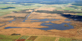
The marshland area has developed by repeated erosion of Saale Ice Age remains in the area, which still form a stable basis in the underground of the Wiedingharder Alter Koog, and subsequent sedimentation by the advancing sea since the end of the last Ice Age. This has generated bog and higher marsh areas, repeatedly flooded and intersected by tidal inlets. A high moraine core is missing below the Gotteskoog polder, were the ground level had never reached the height of the neighbouring, elevated salt marshes. A sand barrier in the west of the Wadden Sea area of North Frisia has kept maritime influence at bay till the high Middle Ages when the North Sea broke the barriers, advanced far inland and inundated especially the lower marshes of the modern Gotteskoog polder, while the higher western parts of the Wiedingharde became a marsh island, comparable to modern Pellworm.
2.2 Present landscape
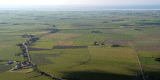
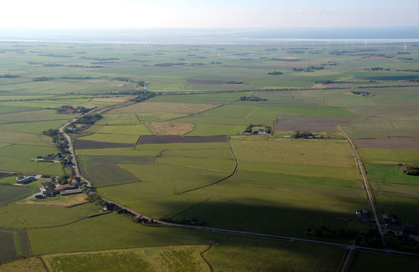
It consists of two major parts; the old marshland polder of the so-called Wiedingharder Alter Koog together with the modern polders in the west separated the low marsh and bog area of the Gotteskoog from the Wadden Sea and inhibited a similar growth of high marshland there. The marshes of Wiedingharde are about 1m above sea level in the west and up to 2m below high tide level in the low Gotteskoog area. They have very little relief and are structured by sinuous roads along the courses of or on top of old dikes and irregular drainage canals in the west. The railway line to Sylt with a parallel road traverses the entity from south-east to north-west. Roads, drainage canals and fields are more rectilinear and large-scale in the south-east and have a totally straight and planned appearance in the far western polder. Fields in the old polders in the west are irregular, small scale enclosures, intersected by sinuous ditches. The marshland is mostly used as pasture and, to a lesser degree, for farming. Areas in the centre and in the north of the Gotteskoog and parts the north-western polder are permanently covered by water. Settlements are arranged in rows in the centre and east of Wiedingharder Alter Koog, sometimes on old sea walls, whereas farm mounds are dispersed in the east. These are supplemented by modern farmsteads in detached location along roads, a settlement pattern that also appears in the western polder. Modern residential areas have spread notably into the marshland around Neuenkirchen and Klanxbüll. Some trees have been planted around farms and within villages as windbreak. Small forests are situated in the Gotteskoog. Houses are usually one to two storeys high and often built in traditional style. Large detached historic farmsteads in a square arrangement are landmarks in the west. Tall constructions are only some churches, granaries as well as wind power generators in the south and along the western dike of the old polder.
3. Landscape and settlement history
3.1 Prehistoric and Medieval Times
Whereas the earliest settlement in Mesolithic times took probably solely place on the moraines and only few traces of that time can be found in the marshland, like flint tools near
Bosbüll, remains of settlements on level ground from the Migration Period, like in
Toftum and
Horsbüll, have also been excavated on the old marshland area of the Alte Wiedingharder Koog, which indicates it to be among the oldest vestiges of marshland in Schleswig-Holstein.
|
 |
|
Line of medieval dike around the Horsbüllharde near
Emmelsbüll-Horsbüll.
© ALSH |
During the early Middle Ages Frisians immigrated into the area of modern Northern Frisia. Reflecting the increasing threat of storm floods, the earliest farms and villages, like
Klanxbüll,
Großbombüll and
Nordhörn, were built on elevated mounds at the western coast from the 10th century on. To this Hallig-like landscape elongated, east-west orientated mounds like
Oldorf were added in the hinterland at a next stage. In late medieval times settlements were then more systematically arranged in long lines of mounds like in
Rodenäs.
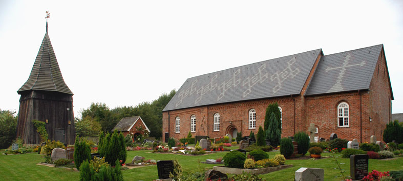 |
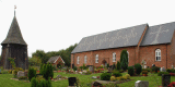
|
Church of Romanesque style l with a separate belfry of later origin in
Rodenäs.
© ALSH |
Some villages had probably been connected by low ring dikes from early stages on, of which the so-called
Schneedeich near Rodenäs or an old dike line connecting northern and southern
Hesbüll could be remnants. This structure of early settlement is still mirrored today by indicated block fields around the earliest village mounds and long, parallel strips of land adjoining the linear settlements and usually separated from other villages’ land by low embankments for water regulation, so-called Sietwenden. The aforementioned
Schneedeich probably served this purpose at a later stage. While the oldest known attempt to embank and in consequence connect this marshland area with the main land is known from the 14th century the construction of a dike surrounding the Horsbüllsharde was only successful in 1465. This first dike line, known as
Golden Ring, is still visible and partially extant. Former mound villages like those of Emmelsbüll or Rodenäs had been integrated into the embankment. The oldest churches of Romanesque style like those of
Aventoft and
Neukirchen are known from the 13th century, often associated with a separate belfry of later time like in
Rodenäs.
 |
| .View on Neukirchen
with wind turbines in the Friedrich-Wilhelm-Lübke-Koog.
© ALSH |
3.2 Early Modern Times
East of this new polder the land was boggy and swampy and under constant influence of the sea. In order to finally connect the new island of Horsbüllsharde to the mainland the embankment of this area was finally achieved in the 16th century via two dike lines in the north and south. The ensuing polder of the so-called
Gotteskoog was shared by Wiedingharde, Bökingharde and Karrharde, the three administration units involved, but was, because of its low and wet ground, for the largest part unsuitable for agriculture. Frequent dike breeches in the following centuries and the draining waters from the surrounding areas led to extended inundations for a long time during the year and made scarce settlement only possible on high dwelling mounds, giving those farms a Hallig-like appearance, as places like
Großhallig or
Hattersbüllhallig still indicate. The numerous disastrous floods left its marks in ponds from dike breeches, like the one near
Norderhof at the
Gotteskoogdeich or like the
Hülltofter Tief. The whole parish of Rickelsbüll west of the old polder even drowned in the waves in 1615. Repeated endeavours to drain the inland water of the Gotteskoog failed but left the large draining ditches of
Rollwagenzug and
Gräslandzug of the 17th century and
Neuer Sielzug and
Gotteskoogstrom as remains of the attempt to lead the water around the polder in the 18th century. The first pumping mills were applied in this time, witnessed by names like Westermühlenhaus near the
Bundesgaarder See.
|
 |
|
The Bundesgaarder See, a reconstructed vestige of the extensive water
body in the Gotteskoog.
© ALSH
|
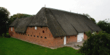
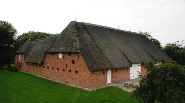
The farmsteads were of the Uthlande type elongated brick-built houses with thatched hip roofs, usually east-west orientated with the entrance at the side. Buildings of the Geesthardenhaus type, originating from the higher Geest, are rarer but close in resemblance. Originally used for animal breeding barns and other extensions required the increasing cultivation of land for farming extended the farm buildings into three- to four-sided and five- or seven-shaped structure, visible today in places like
Charlottenhof.
|
 |
|
The Charlottenhof, a four-sided farmstead with courtyard of the
Uthlande type.
© ALSH |
Farm buildings were either closely built due to the little space on dwelling mounds or arranged in parallel estates on either side of the roads. Types like the Haubarg play no role in this area as modern Frisian immigration, like in Eiderstedt or Dithmarschen, has not taken place on a larger scale.
3.3 Modern Times
The area became isolated from its former administrative centre Tondern in Denmark after the First World War, when the Wiedingharde voted to remain within the Deutsches Reich, whereas the areas in the north chose to belong to Denmark. This promoted the improvement of traffic infrastructure to Niebüll and massive development programs for the Gotteskoog. During the 20th century the drainage situation in the Gotteskoog polder chanced dramatically with the introduction of engine powered pumps. From the 30ies on pumping stations like Schöpfwerk
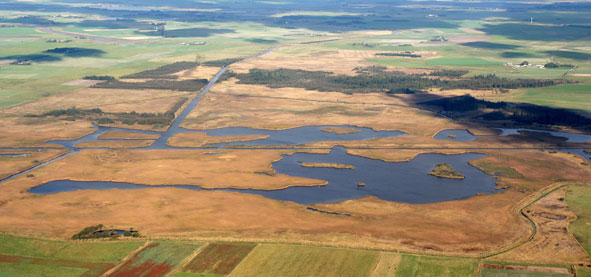
Verlath, built in 1933 and out of use since 1977, lowered the water level considerably and prepared, in connection with measurements for soil improvement, the land for agricultural use. During the Nazi period first roads were built and new farms founded but only the vast interventions in connection with the Programm Nord since the 1960ies gave the Gotteskoog the modern appearance of a farmland area with straight roads and few planned farmstead with little that reminds of former times of almost constant inundation and the subsistence on small scale animal breeding and reed cutting. Only small parts of the former lakes of
Gotteskoog,
Aventoft and
Ruttebüll have survived, re-naturalized since the 80ies in order to retain at least bits of the former landscape. The Programm Nord and modern industrialised agriculture have also chanced the appearance of the traditionally small scale fields and pastures considerably into larger, uniform looking structure now usually intensively cultivated in comparison to former extensive life stock breeding. The difference can be measured with a look across the border onto the Danish Tönder marsh has retained this appearance to a much larger
extend.
|
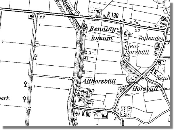 |
|
Medieval dwelling mound of Althorsbüll with medieval fieldscape
(right) and polder of the 20th century (left). ©
VermA-SH |
In 1927 the railway line to the
Hindenburgdamm was constructed from Niebüll to Sylt, which cut right through the Wiedingharde and connected it eventually to the modern net of transports. In the subsequent 1930ies the famous local painter Emil Nolde built his abode on a dwelling mound in
Seebüll, which has later become a highly frequented museum. Few small polders, like the
Alter Friedrichenkoog today being on Danish side, had been added since the Gotteskoog polder was gained, when in 1954 a new, large polder was embanked in the west due to accretions of marsh land along the Hindenburgdamm. This so-called
Friedrich-Wilhelm-Lübke-Koog reflects the planned structures of the Programm Nord in its uniform appearance of fields and farm houses, the latter being designed in a competition. The new land was equally divided between locals and war-immigrants from the former German eastern provinces and is still intensively used for farming. The last polder to be built was the
Rickelsbüller Koog in 1982 together with the Danish
Margrethenkoog north of the Hindenburgdamm as coastal protection measurement, solely used as nature and bird sanctuary.
4. Modern development and planning
4.1 Land use
The Programm Nord and modern industrialised agriculture have chanced the appearance of the traditionally small scale fields and pastures considerably into larger, uniform looking structures now usually intensively cultivated in comparison to former extensive life stock breeding. The difference can be measured with a look across the border onto the Danish Tönder marsh, which has retained this appearance to a much larger extend. However, soil quality is rather poor in comparison to other marshland areas. A certain restoration of the former wetland aspect in the Gotteskoog has been executed since the 1980ties. An actual project aims at restoring parts of the historical wetland landscape, mostly by contract-based nature protection and co-operation with organisations for water regulation. The last polder to be built was the Rückelsbüller Koog in 1982 together with the Danish Margarethenkoog north of the Hindenburgdamm as coastal protection measurement, solely used as nature and bird sanctuary. Untypical forests were planted on the Kopshallig in the Gotteskoog Lake and near Aventoft. Some municipalities like Niebüll and Klanxbüll plan for forested areas of different sizes in the marshland close to the villages. These are not meant to be windbreaks as trees have been used since the 1800s in the marshes.
4.2 Settlement development
Some settlements, like Neukirchen or Klanxbüll have spread far beyond their original confines due to demand for new houses by the inhabitants and for second homes by tourists owing to the boomed prices for estates on Sylt. Wiedingharde is rated as tourist and recreational area and tourism plays an increasingly important role in the areas income. An information centre in Klanxbüll and even a small open-air dike museum at Neukirchen are, besides the famous Emil-Nolde-Museum in Seebüll, available for visitors’ information and as attractions.
4.3 Industry and energy
Wind turbines have been erected during last decades, especially in the Friedrich-Wilhelm-Lübke-Koog and near Bosbüll. The areas around Emmelsbüll and Klanxbüll are designated as future area for wind power generators while the land north of the railroad track is protected against the construction of wind power generators. However, local planning is applying for new wind turbines in the north-eastern corner of the Gotteskoog. A mussel desanding facility at Emmersbüll is the largest facility of its kind in the region.
4.4 Infrastructure
The area has a network of roads mostly based on historic routes and connections between settlements and often built on top of former sea walls. Most roads in the Gotteskoog are modern. The railway track to Sylt crosses the area, connecting Klanxbüll to Westerland.
5. Legal and Spatial Planning Aspects
The northern parts of the former Gotteskoog area fulfil the requirements for a landscape protection area. The western parts of Alter Wiedingharder Koog are regarded as structurally rich landscape. The area north of the railroad track is recognised as typical landscape for the region. However, no new protection areas are planned to be implemented in North Frisia. Nature protection rather aims at further integrating agriculture and promoting extensive stock breeding and contract based nature protection in the old polders, like the area of the former Gotteskoogsee and Ruttebüller See. Furthermore, it is suggested to raise the number of so-called typical landscape elements and to integrate existing elements into the network of biotopes and protection areas, like Rickelsbüller Koog. The landscape plan supports the integration of historic settlement structures into planning. The tourism concept for North Frisia promotes a sustainable development in this sector. An improvement of landscape related tourism together with riding, cycling and hiking is suggested by landscape planning.
6. Vulnerabilities
Old farms buildings are overshadowed by numerous and dominant modern agricultural buildings. Traditional field structures and, in the Gotteskoog, the whole system of subsistence have substantially been altered by the Programm Nord. Often, unprotected monuments are still subject to being dug away or levelled. The chance of artificial into natural waterways in the course of actions according to the Water Framework Directive could affect the cultural landscape severely. There are single local plans for forest plantations. Further strong demand for new residential and industrial areas on Sylt will also increase the demand for real estate and enhance the landscape change around the already affected areas of Klanxbüll and Neukirchen. Wind turbines in sensitive landscape areas of small-scale historic structures free of wind parks will alter the historic landscape aspects significantly. This applies to planned forests even on a much larger scale, as they are not only traditionally alien to the marshes but also block the view into the open landscape.
7. Potentials
As one of the oldest marshland areas in Northern Frisia, the area of Wiedingharder Alter Koog, still strongly reflects exemplary the layout of the different stages of medieval settlement and land reclamation. The Gotteskoog polder is an amazing example of the variety of landscape in the Wadden Sea Area as its former inland Hallig landscape is unrivalled and it, as well, underlines in a most drastic way the rapid changes modern technique brought about in the area. The northern parts of the entity are little tangled by wind power generators. Nature sanctuaries are available on a larger scale in the Rickelsbüll polder and in low, unfertile areas of the Gotteskoog polder. New developing areas are confined to few, already noticeably altered villages like Klanxbüll, Neukirchen. The project “Noldes Landschaft” in connection with the museum and the adjoining Danish municipalities tries to reconstruct parts of the historical landscape of the beginning of the 20th century in the Gotteskoog. The co-operation between the area and the bordering Danish area is increasing. Further restorations of wetland along the canal Schmale and low lying areas in the Gotteskoog polder are planned.
8. Sources
Author: Matthias Maluck
General literature:
Vollmer, et. al. (eds.) 2001. Landscape and Cultural Heritage in the Wadden Sea Region – Project Report. Wadden Sea Ecosystem No. 12. Common Wadden Sea Secretariat. Wilhelmshaven, Germany.
Innenministerium des Landes Schleswig-Holstein (eds.) 2004. Regionalplan für den Planungsraum V, Amendment File.
Ministerium für Umwelt, Natur und Forsten des Landes Schleswig-Holstein (eds.). Landschaftsrahmenplan für den Planungsraum V. Kiel 2002.
Kunz, H. & Panten, A. 1997. Die Köge Nordfrieslands. Bredstedt.
Bantelmann, Landschaft und Besiedlung Nordfrieslands in vorgeschichtlicher Zeit (Husum 1992)
Bantelmann, A. (ed.) 2000. Das große Nordfrieslandbuch. Bredstedt.
Gemeinsames Wattenmeer Sekretariat (ed.) 2005. Das Wattenmeer. Theiss Verlag Stuttgart.
Beseler, Kunst-Topographie Schleswig-Holstein (Neumünster 1969)
Braun, Strehl (eds.), Langhaus und Winkelbau. Uthlandfriesische Bauformen im 18. und 19. Jahrhundert (Bredstedt 1989)
Vogel, Der nordfriesische Geestrand, die Entwicklung seiner ländlichen Siedlungen und ihrer Flurformen (Bräist/Bredstedt 1996)
Fahrenkrug et. al. Regionales Entwicklungskonzept Nordfriesland (unpublished, 2003)
Gottburgsen, M., Hassenpflug, W.. Der Gotteskoog (Bad Honnef 1991)
Segschneider, M. Die Marschen der Insel Föhr und der Wiedingharde, Kreis Nordfriesland. PhD thesis Kiel 2004
Maps:
Archaeological monument record of Schleswig-Holstein and gis mapping
Lancewad data base and gis maps
Royal Prussian ordnance survey of 1879
Map of H. du Plat of 1804/05
|