|
1. Overview
|
Name: |
The Wash |
|
Delimitation: |
The estuarine embayment
of The Wash and its maritime influenced hinterlands, as depicted in
Figure 1 |
|
Size: |
around
2,450 km² |
|
Location
- map: |
The Wash and its
hinterlands on the eastern coast of England; shared between the
counties of Cambridgeshire, Lincolnshire and Norfolk; United Kingdom |
|
Origin of name: |
What was aptly named
Metaris A Estuarium – a bay with tidal marshes
and mudflats – back in Alexander the Greats day started to become
known as The Wash much later on. The first true recorded use of the
word Wysche or Waashe was used in the sixteenth century and described
only the tidal areas of the Rivers Welland and Nene. A century on the
area was referred to as The Washes being a ‘a very large arme’ of the
German Ocean. All old accounts refer to the great body of water that
then flowed away on a tide to reveal dry land of great danger. |
|
Relationship/similarities with other cultural entities: |
The project entity area
has an intricate relationship with the adjacent fenland area, which
also reaching back through the years was influenced by being tidal or
from sudden inundation from the sea and rivers. The deeper fen becomes
more peat like in character than that incorporated in this project
area and in the most southern reaches there are true hill forms where
historic towns such as Warboys and the cathedral settlement of Ely sit,
which were once surrounded by a waterland as isles in the Fens. The
similarities between The Wash and Wadden Sea in their cultural
landscape evolution, is one of the main reasons for sharing
experiences through the Lancewad Plan Project. For example, in more
recent history the use of duck decoys in Alter Koog within the
Nordstrand entity of Schleswig-Holstein are similar to those that was
used all around The Wash, and still exist today for example at
Friskney in Lincolnshire. |
|
Characteristic elements and
ensembles: |
Evidence of prehistoric
and medieval life including for example, Roman crop marks and Iron Age
salterns; settlement patterns relating to uplands in the east and
higher inner fenland ridges; Norman building programme evidence in
churches and castles; maritime and farming sectors evident throughout
including evidence of land reclamation and drainage in lower lying
areas of western and southern reaches of area. |

2. Geology and geography
2.1 General
In its current form, The Wash is an embayment of the North Sea, the largest
estuarine system in the UK today. The hinterlands behind the sea embankments
were once part of this system, and a much larger area of marsh and fenland,
known as the Fens, which spread as far south as beyond Ely in
Cambridgeshire. The five rivers that drain into The Wash today – Rivers
Steeping, Witham, Welland, Nene and Great Ouse - drain over 12% of England.
There used to be other rivers that now have been channelled into these five
remaining estuaries.
Within the entity project area the hinterlands still reflect their maritime
past, as do the historic settlements of the area. Severe storms and
associated flooding have punctuated the social history of this area, and its
landscape. It has been progressively submerged by rising seas over the last
10-12,000 years. Offshore there are submerged peat and land surfaces, with
associated human artefacts. The submerged sediments are basically continuous
with the reclaimed areas of the Fens, although in places early deposits have
been eroded by deep channels. It is likely that there are historic wrecks
preserved beneath the seabed, but these remain undiscovered due to the
shifting nature of the sands and mud of The Wash.
|
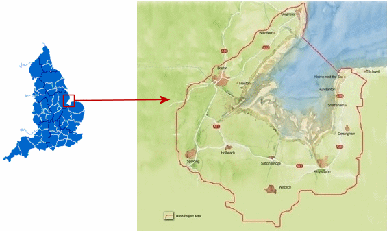 |
Map showing regional and county boundaries of England.
©
English Nature. |
Map of project area with red line delimiting the entity
which falls into three counties, from west to east; Lincolnshire,
Cambridgeshire, and Norfolk. It is also split between two government
regions known as East Midlands on the western side and East of England
in the eastern section.
Water colour map by Sam Wilson based on aerial
photography supplied by Environment Agency.
©
WESG |
2.2 Present landscape
The Wash entity area is split into two distinct landscapes, one representing
the wilder, more naturalised vista which is defined by the North Sea,
saltmarsh, mud flats and five river estuaries, which then reaches the foot
of a sea embankment. On the other side is a landscape manicured by man,
dominated by a rural appearance on the whole with church spires, mill towers
and the odd other tall structure punctuating the skyline. There are
scattered market towns that follow the lines of old transport routes and
identify slighter higher ground, with the historic ports towns of Boston,
Spalding, Wisbech and King’s Lynn being the major settlements with the
outlying seaside towns of Hunstanton and Skegness guarding the mouth of The
Wash with their golden beaches.
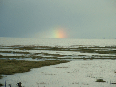 |
 |
| The wilder land and
seascapes on the seaward side of the embankment.
© Jon Watson |
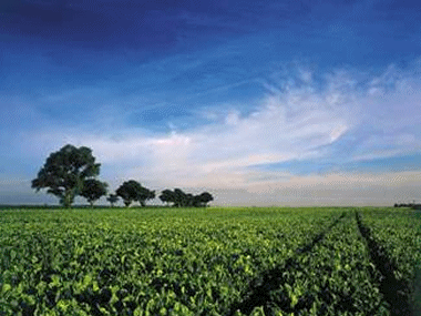
Cultivated
landscapes on the other side of the sea embankments.
©
Fens Tourism |
The hinterlands of The Wash vary from east to west in character with over
two-thirds being somewhat similar in character and the most eastern edge
evolving into a quite different character. In the western, southern reaches
through to just above King’s Lynn there is little relief greatly above sea
level, being flat and on a wider scoping range, generally open. The main
vertical elements relate to settlements and farmsteads, such as shelter
belts, church steeples, industrial buildings and an increasing number of
wind turbines; and the odd remaining duck decoy. Many waterways of varying
size criss-cross the land of large agricultural and horticultural fields.
There is little livestock associated with this area; the odd sheep grazing
harvested brassica fields and cattle out near the open, wild Wash where they
wander the saltmarsh in the summer. Farm reservoir banks, old sea and river
embankments, and salterns are the only true undulation in the landscape. The
older settlements tend to be linear following old trading routes or droves.
 |
Whereas
the eastern hinterlands of Norfolk, north of King’s Lynn, do have
relief features in the form of cliffs at Hunstanton which reappear
near Wolferton village within Sandringham Estate. There is a gentle
undulating landscape that is predominately farmland but of a more
intimate scale than the open landscape around the corner of The Wash
towards the west. Trees and woodlands feature much more greatly here,
and the church spires are lost much more easily amongst the hills and
woods. In part, this area has been nationally designated as an Area of
Outstanding Natural Beauty, which is a landscape based designation
which includes placing statutory duties on relevant bodies to ensure
it maintains its character and beauty. Remnant sea banks do not tell
the story of the land here, but Norman Keeps make a hint towards past
landscapes. |
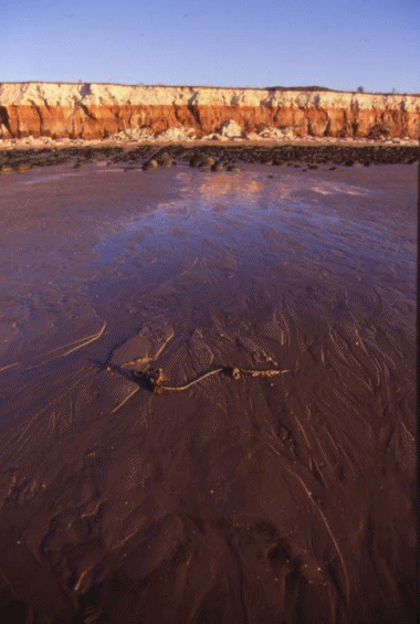
Uplands of the eastern Wash coastal line that
feature inland further south within the entity.
©
Borough Council of King’s Lynn & West Norfolk |
|
3. Landscape and settlement history
3.1 Prehistoric and Medieval Times
The Wash and its hinterland are made up of many metres of sediments that
have been gradually deposited since Mesolithic times (from around 5400 BC)
due to a combination of estuarine and freshwater conditions reflecting
periodic sea level rise and fall across the original dry, wooded basin
landscape. Across and within the deposits of the Fens lies a record of human
history, showing evidence of Neolithic, Bronze Age, Iron Age and Roman
habitation, industry and communications. Archaeological treasures include:
pottery, flints and ceremonial monuments of Neolithic age (4500-2000 BC) and
Bronze Age field systems, settlements and round burial barrows. During the
Iron Age and Roman period a salt production industry developed around The
Wash. The evidence shows there was a second coming of salt making in the
Medieval times, no evidence has been found as of yet covering the Saxon
period.
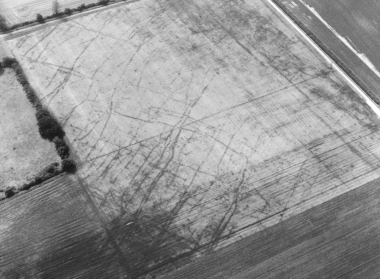 |
Late Iron
Age/Romano-British field systems near Snettisham in Norfolk.
©
Norfolk County Council |
Within the
light and comparatively fertile chalk soils of north west Norfolk there has
been human settlements with cultivation evidence right back to the Bronze
and Iron Age, which continued through the Roman times, particularly being
influenced by the fact that it ran near a major military route north to
Brancaster and Holme. Throughout the Medieval times the settlement pattern
centred on commons and greens which proliferated along the rising ground
heading east, and in some cases settlement concentrated on military or
commercial centres, such as Castle Rising, or ecclesiastical centres such as
the Cluniac priory of Castle Acre. By the late Medieval period, there was a
widening of sheep walks and warrens which were both subject to manorial
control.
The silt-based Fens, which stretch from King’s Lynn towards Boston have a
long settlement history going back to the Romano-British period and beyond.
Roman settlement saw the first attempts of land drainage, when the sea level
was about twenty feet lower than now with the marshy coast being sheltered
by offshore banks and shoals. Monastic institutions played an important role
from the 7th century onwards, due to undertaking large scale drainage works.
The associated religious settlements were established on the fen edge or on
isles, such as Crowland and Ely just outside of The Wash project area.
|
The sea level started to rise in about the second century with the
fenland lagoon silting up quickly. The settled fen, otherwise known as
the town lands, with a variety of villages and larger towns, mostly
being medieval in origin with fine medieval churches, formed an arc
around The Wash. These are either positioned on higher grounds of the
courser material or on navigable rivers where they performed as either
inland ports or coastal ports, such as Wisbech and Boston. This
pattern of settlement was largely created by a pastoral economy with
large irregular enclosures around villages and the fen edge, with
embankments happening on either side in the marshes towards The Wash
and in the fen on the opposite side of the ridge. Some of the names of
these settlement are English in origin and others illustrate relations
with neigbouring North Sea countries, such as Skirbeck and Wrangle
relating back to Danish conquerors. Towns such as Boston and King’s
Lynn flourished in the medieval times through trade with mainland
Europe, wool in particular.
|
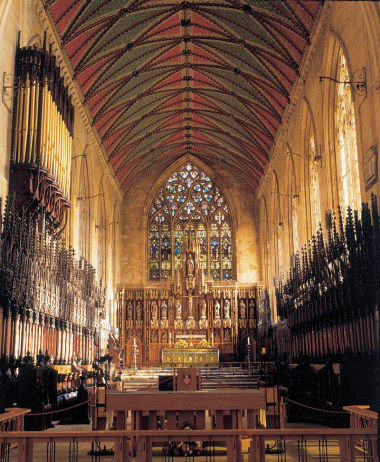 |
| |
The grandeur of St. Botolph’s Church in Boston –
locally known as ‘The Stump’.
©
Fens Tourism |
This mass of
trade of importing wine, timber, cloth and stockfish; exporting wool, cloth
and grain saw smaller ports expanding all along the coast from Skegness to
Wainfleet, to Surfleet to Gedney through to Cambridgeshire and Norfolk. This
trade was underpinned by the great religious houses of the area, who owned
large sheep flocks, and had land for saltmaking and fisheries fleets.
The 13th century saw a time of change with periods of dramatic sea rise and
tidal surges overtopping the banks to reshape the coast and reduce the
grazing to summertime only. The Medieval defensive clay banks of this time
are still misnamed today as ‘Roman’. Natural drainage deteriorated because
the gradient lessoned and large drainage projects of the inland areas were
thwarted by ‘intercommoning’ practices.
3.2 Early Modern Times
The area was gravely impacted upon by the deteriorating climate and the
plague. Ports declined due to the migration of new technologies and
industries from the power of the urban guilds’ restrictive control and due
to the demise of diplomatic relations with the European Low Countries.
Another factor in the decline of such towns related to sources of salt with
greater purity being marketed elsewhere. This saw towns like King’s Lynn and
Boston become market towns by the 16th century, instead of being the
previously important regional trade centres of times before, and various
smaller havens went into total decay.
By the mid to late 16th century the process of coastal reclamation had began
with small sites at Gibraltar Point south of Skegness, and a new drain being
cut in Boston called the Maud Foster in 1568. But these were nothing in
comparison to the changes driven by the 4th Earl of Bedford and his engineer
Sir Cornelius Vermuyden, and in some cases Sir Philibert Vernatti. With a
Royal Charter from Charles I, they made drowned land ‘fit for tillage and
pasture’, which had previously been under monastic control. This was the
start of seeing the area change from grassland and water dominated landscape
to one we associate with more today, a highly cultivated and managed one.
Other major players in this change included the Earl of Lindsey. Drains such
as Vernatt’s in the Spalding area, and the South Forty Foot cutting from
Kesteven to Boston area saw huge areas of common land drained, and coastal
embankments saw large areas reclaimed from the sea, such as 1,120 acres at
Tydd St Mary on the Nene estuary in 1632. By 1660, 17,374 acres had been
embanked from Gedney to Moulton, and the whole of Bicker Haven cut off from
the sea.
Fewer large scale drainage works occurred throughout the 1700s, although
many improvements were made to those that had happened previously including
the straightening of water courses. The efficiency of gravity drainage
decreased further in this time and so the use of wind pumps became
essential. This had major implications for the Fens skyline, as can be seen
below.
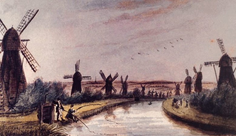 |
| Wind pumps became essential in maintaining
drainage by the 1700s.
©
Fens Tourism |
With the
drainage and reclamation small farmsteads started to appear outside of the
townland belt of settlement, and drove ways, known as ‘The Smeeth’ were
created running along the cultivated fields to the coastal marshes. Most
buildings in the open, inland fen are post 1750. The productivity of the
reclaimed soils soon saw the development of extensive areas of high grade
arable cultivation, over summer grazing, and it is still the dominate land
use today.
Within north west Norfolk on the chalklands tree cover had been greatly
removed by the 17th century, which saw a change in building materials. There
is a general dominance of flint from the chalk and carstone from the
greensand ridge being used within buildings. Within the valley bottoms
open-field systems continued to be unenclosed into the 18th century, whereas
enclosure was largely complete up on the poorer and more acidic soils of the
greensand ridge and chalklands by the 18th century. It is on the uplands
that large estates formed, which the area is still famous for today, such as
Sandringham and Houghton.
3.3 Modern Times
John Rennie, engineered one of the last great drainage actions of the 19th
century that saw over 40,000 acres drained of the East, West and Wildmore
Fens in 1801-1814 north of Boston. By 1866, steam pumps were introduced to
this area, having been installed much earlier to more southern reaches of
the Deeping Fens south of Spalding in 1827. The impact steam pumps had on
the landscape was not only visual but also of an auditory nature. Larger
pumps and associated housing were introduced as sea-levels continued to rise
throughout the area, and water management structures still feature in the
landscape today, and some of the old steam pumps provide an opportunity for
socio-economic activities through acting as visitor attractions for the
area, such as the Pinchbeck Engine and the open days ran by the Internal
Drainage Boards, for example, the Lindsey Marsh Drainage Board’s Historic
Land Drainage Working Demonstration days.
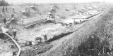
 |
| Drainage works on the South Forty Foot Drain.
©
Black Sluice Internal Drainage Board |
Coastal reclamations continued into the 20th century, with the last
occurring north of Boston between Freiston and Butterwick in the late
1970s/early 1980s. We have now seen a reversal of this process at that exact
site, with a managed realignment being undertaken for flood risk management
reasons, resulting in the creation of 80 hectares of saltmarsh and several
saline lagoons that support a new visitor attraction, Freiston Shore Nature
Reserve.
The A52 is the main trunk road between Boston and Skegness which even today
has many curves and sharp corners, probably reflecting what was once a
causeway that followed either an embankment or the townland upper silt
ridge. The settlement pattern within The Wash hinterlands only truly began
to alter with the development of new roads such as the A17 and A47, which
has resulted in the townlands settlements spreading along the routes.
The dispersed farmsteads of the 19th century tend to be red/buff brick
dwellings, with the mud and stud walling that once was used almost in none
existence. The roofs are tiled with red pan-tiles or more commonly Welsh
slate. The field patterns that surround these farmsteads are ancient,
semi-regular relating to the aforementioned ‘The Smeeth’ or drove roads.
 |
Field
patterns of today illustrating past land use – Holbeach and Whaplode
Droves reclaimed in early medieval, c.1241.
©
Lincolnshire County Council |
Duck decoys
also sprang up around The Wash, some of the best in the country and some of
these still feature in the landscape today but many were lost as farming
became more intensified. These remain the only tree cover other than
shelterbelts. Fields further inland become dominated by vast rectilinear
patterns within straight roads and drainage features, where boundaries are
defined by ditches and drains, rarely hedgerows.
Whereas, over on the eastern section of The Wash area in north west Norfolk
the fields are enclosed by thorn hedges and it is greatly defined by vast
estates which developed in the 18th and 19th century with large boundary
flint and brick walls, lodge buildings and parkland plantations. The actual
estate houses vary in style and are often concealed from view within the
large scale geometric enclosed landscape. There is greater tree cover in
this landscape with large woodland blocks.
4. Modern development and planning
4.1 Land use
The predominant use of the area still remains to be agriculture and
horticulture. The intensification period in the last 50 years has seen
changes for the landscape – further straightening of field systems, grubbing
out of older sea embankments for more tillage land and less livestock. But
in very recent times, there has been a creep back towards ‘slower’, less
intensified farming with the re-introduction of livestock, organic farmers
with grassland reappearing. It is unlikely this will affect the whole area
but it brings back some diversity to the landscape that had, in part, been
lost. Also changes in support for farming communities has resulted in
landscape impacts, such as crop coverage being different and agri-environment
schemes supporting the protection and enhancement of some characterising
elements of the landscape.
4.2 Settlement development
Increased tourism, either related to in situ or transient visitors, and
people moving from the south into the area for a slower pace of life and
cheaper housing, is helping secure an increase in the need for development
in the area. The supporting infrastructure along major roads is also
increasing, and gradually what once were independent settlements seem to be
merging. Some of this development works with the local character of the
buildings, and some does not. In the eastern section, moving towards north
Norfolk, second homes becomes more of an issue where there are villages that
only come to life at the weekend or at holiday times. Various policies
within local planning and policy documents have been developed for these
honey-pot areas to help curb this phenomenon and build a more sustainable
type of tourism, whereas in other parts of the entity this is not as of yet
an area of concern.
4.3 Industry and energy
In recent years there has been an increased use of the area for energy
generation including gas powered stations, to even more recently modern wind
turbines (2005-6). At present these all seem to centre on the southern
section of The Wash hinterlands. The development of offshore wind turbines
is also new to the area, although the actual turbines are not allowed within
The Wash, they are being built off the coast of Skegness near the mouth of
the embayment, and proposals to cable the extremely large windfarms through
The Wash are currently under consideration. There are implications for the
onshore landscape, as well as the offshore seascape, in terms of national
electricity grid connections needing to be enlarged. There are also various
large processing and packaging plants relating to produce grown from the
land scattered throughout the area, but with a particularly high
concentration around Spalding. Often they are alongside the major trunk
roads, as there is little serviced by rail. Haulage companies have
proliferated in the area.
4.4 Infrastructure
There are no motorways crossing the area. The major northerly trunk road
into Norfolk, the A17, cuts right through the entity including various
bridges crossing the rivers, one of which at Sutton Bridge is a historic
listed structure. The other major road is the A52 cutting through the
western side. There is a noticeable increase in traffic in the spring and
summer relating to tourism. No ferries sail from the ports, but the
commercial ports of Boston, Sutton Bridge and King’s Lynn see much shipping
traffic of container goods, timber and the like. Boston and King’s Lynn also
still support fishing fleets that harvest shellfish, in the most part, from
The Wash. The port of Wisbech is further inland on the River Nene, and as
well as still being commercially active, it has developed as a yacht harbour
for smaller craft with a series of wooden pontoons along the historic
quayside. There also used to be an active, commercial port at Fosdyke on the
River Welland, but a thriving yacht yard has now replaced it. There are
works underway to join-up various rivers and waterways to make it possible
to travel between them, presently including linking the River Witham with
the South Forty Foot Drain in Boston.
5. Legal and Spatial Planning Aspects
There are a suite of statutory plans that relate to this area at various
levels.
These include:
The Wash embayment is a highly designated site from international level to a
local one. Designations include Ramsar, European Marine Site, Special
Protected Area, Special Area of Conservation, Site of Special Scientific
Interest, National Nature Reserve and Local Nature Reserve. All of these lie
within legislation relating to nature conservation from global agreements on
wetlands, to European birds and wildlife protection, to national and local
considerations.
Part of the entity falls within a national landscape designation of an Area
of Outstanding Natural Beauty (AONB). This designation seeks to ensure the
conservation of natural beauty within landscape, and the North Coast AONB is
part of a national network of sites alongside National Parks that protect
precious areas. As of 2000, it became a statutory duty for relevant local
authorities or conservation boards to prepare and deliver a management plan
for these sites.
Two Regional Spatial Strategies/Plans for East of England and East Midlands
– these include such framework policies as; to protect and enhance the
region’s natural and cultural assets, and; that new developments respect and
enhance local character. These policies seek to influence local planning
authorities, amongst others;
The Wash Estuary Strategy Group is a non-statutory partnership that
practices Integrated Coastal Zone Management and works to deliver
sustainable development principles in the area through influencing others
and taking direct action. They produced the Wash Estuary Management Plan
(2nd edition) through fully engaging with the local communities and
stakeholders in the area to develop policies that set out an agreed holistic
framework for the area, including for cultural assets – historic environment
and landscape. This has resulted in further action, including developing
spatial planning tools for the cultural landscape and assets of the area.
Local district/borough plans for East Lindsey, Boston, South Holland,
Fenland and King’s Lynn & West Norfolk. There is a process at the moment
from moving from Local Plans in the planning authority areas to Local
Development Frameworks (LDF) which engages the local community much more in
local decision-making. LDFs will be supported by a body of evidence, and
most planning authorities will include a Landscape Character Assessment and
a Historic Landscape Characterisation report. Hopefully in The Wash area
this will include the characterisation report being developed for this
entity through the Lancewad Plan Project. It is also the local planning
authorities who designate conservation areas within cultural townscapes,
which aims to ensure the historic character of a townscape is maintained
which also ensures the townscapes influence on the wider cultural landscape
is maintained.
There are128 Scheduled Ancient Monuments and 2,168 listed buildings and
structures. 'Scheduling' is for nationally important sites and monuments
that are given legal protection. English Heritage takes the lead in
identifying which should be placed on the schedule by the Secretary of State
for Culture, Media and Sport. The current legislation, the Ancient Monuments
and Archaeological Areas Act 1979, supports a formal system of Scheduled
Monument Consent for any work to a designated monument. Scheduling is the
only legal protection specifically for archaeological sites. ‘Listing’ helps
protect the best architectural heritage, and when a building is listed it is
placed on the ‘special architectural or historic interest’ list compiled by
the Secretary of State for Culture, Media and Sport under the Planning
(Listed Buildings and Conservation Areas) Act 1990, based on advice from
English Heritage. Both of these systems are under Governmental review, and a
White Paper called Heritage Review is currently being consulted on, and so
things may change.
6. Vulnerabilities
Climate change and the push by central Government to meet renewable energy
targets and reductions in carbon dioxide emissions are seeing a large
increase in applications for windfarms in the area. There is a need for a
greater strategic view in terms of the landscape capacity instead of a site
by site process, which some of the planning authorities have undertaken.
Cultural character and heritage assets need to be a material consideration
in the development of such guidance not just proximity to urban areas. This
should also be the tact for traditional power station developments. Climate
change also presents a direct threat to the cultural landscape in terms of
sea level rise, ocean acidification and more storm events. All three may
squeeze certain landscape elements out of existence and the cultural
activities they support, and storms may drastically alter coast lines, cause
flood and wind damage with more acid causing erosion of archaeological and
built elements.
Farming continues to be an issue and an opportunity for cultural land and
seascapes. The loss of family businesses with the increase in large
agri-businesses can lead to yet more old embankments being lost and curvi-linear
features representing old creek systems. Larger plough machinery can cause
damage to ground based defining elements, such as salterns. Also the change
from growing traditional crops to biomass fuels may be a particularly issue
in the future, as it is already starting to be in other parts of the
adjacent areas. Continued growth of associated infrastructure is gradually
degrading areas, including it getting larger in scale such as glasshouses,
and/or, packing sheds made out of box profile sheeting instead of
traditional materials, and it is often the associated industries that are
infilling along the major highways between settlements.
Increased development within settlements or piecemeal throughout the rural
reaches, not only can depreciate the distinctiveness of an area if done
insensitively, but puts greater pressure on natural resources including
water and the need for greater protection from natural events. Greater
efficiency in drainage causes desiccation of ancient monuments within the
landscape and more stringent flood risk tools can chip away at character
through reducing the tidal influences in historic ports or via rock armour
being placed in front of cliff lines.
Inappropriate tourism driven developments gradually redefines an area, so
old Victorian resorts lose that connection, or the drive for marinas and
economic regeneration leads to distinctive, historic quayside becoming the
same as every other café culture waterfront within the country. These issues
are currently on the horizon for the area, and may not be the end point if
the decision-makers take cultural land, urban and seascapes as a serious
material consideration, particularly as it may give the edge over other
visitor destinations.
Conservation legislation in itself can be a barrier to ensuring that
cultural assets within a landscape are managed proactively through placing
too much red tape between the best intentions of an owner and the ability to
achieve it. This can, and has, resulted in neglect as being the easiest
option.
7. Potentials
The cultural heritage infrastructure, as part of the whole areas green
infrastructure, offers opportunities for socio-economic regeneration and
risk management. By restoring more of the historic landscape by
re-introducing wet fenland and flood plains at appropriate sites in the
inland sections of the area, sustainable fluvial flood risk could be
achieved alongside biodiversity gain, economic regeneration and social
access to the area. This kind of risk management can also be used at the
coast. Within The Wash entity, a coastal management realignment has already
seen a reintroduction of an earlier Victorian sea embankment and hotel,
providing more sustainable flood risk. It has also created a local nature
reserve which is supporting on average of 60,000 visitors per year, which
has seen an increase in spend at local historic public houses and other
businesses.
The numerous waterways and historic sea embankments also provide a huge
network that could be integrated better into the local communities and
visitors accessing the countryside and appreciating the cultural landscape
of the area. In so doing it would place value on them and lead to better
management. This in part is being realised through the Fens Waterways Link
Project, which is a long-term vision to re-connect the cathedral cities of
Lincoln, Peterborough and Ely via navigable historic waterways, which
includes linking up with Boston, Wisbech and King’s Lynn.
Agri-environment schemes can re-introduce, enhance or protect various
elements that define local distinctiveness within the cultural landscapes.
Other resources can support communities to rebuild elements of their local
environment, such as restoring historic structures that define the skyline
for miles around, or, awareness raising activities with land owners of the
importance and opportunities that the sea embankment network offer in an
area with few rights of way.
Strategic spatial planning tools for the area are being developed through
the Lancewad Plan project for the cultural landscape, which will identify
further issues and actions for the area through working with the local
stakeholders using various character maps that have been produced. A spatial
coastal zone management plan through the fully revised second edition Wash
Estuary Management Plan already sets out policies regarding the landscape
and historic environment. And it has now been recognised that an integrated
Green Infrastructure Master Plan to take into account the growth in the area
will further help sustain the special qualities of the area. The review of
The Wash Shoreline Management Plan, which is the long-term policy setting
document for flood risk management and coastal protection, also offers an
opportunity to influence future management of the area. All of these can
provide an evidence basis for planning guidance and appropriate development
control decision-making.
Through promoting and implementing these tools and opportunities at various
levels, horizontally and vertically, it should ensure that the cultural
landscape of The Wash is allowed to continue to evolve but in a sensitive
manner that respects its history – socially and naturally.
8. Sources
Author: Tammy Smalley
General literature:
Roberts, B. K. & Wrathmell, S. (2000): An atlas of rural settlement in
England.
Bennett, S. & Bennett, N. (1993): An historical atlas of Lincolnshire.
Heaton, A. (2001): Duck Decoys.
Sir Payne-Gallwey, R. (1886): Book of Duck Decoys, their construction,
management and history.
Countryside Agency (1999) Countryside Character, Volume 4: East Midlands and
Volume 5: East of England. Fenland Survey: an essay in landscape and
persistence.
Hall, D & Coles, J.M. (1994): English Heritage Archaeological Report.
Robinson, D. (1981): The Book of the Lincolnshire Seaside.
The Norfolk Coast Partnership (2004): Norfolk Coast Area of Outstanding
Natural Beauty Management, first edition.
Hallam, H. E. (1965): Settlement and Society: a study of the early Agrarian
history of south Lincolnshire.
Hoskins, W. G. (1977, 2nd ed.): The making of the English countryside.
Wash Estuary Strategy Group (2004): Wash Estuary Management Plan, second
edition.
|