|
3.7
Cross
section The Wash
1. Map of the cross- section
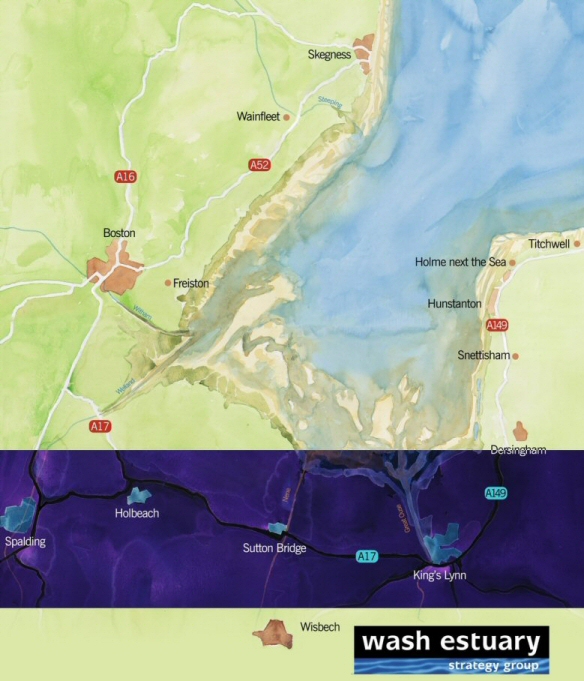
Cross section in the Wash Area (blue)
The Wash is found on the east coast of middle
England. The Wash crosses a government regional boundary between East
Midlands in the north-western section and East of England found in the more
eastern part of The Wash. The shoreline is shared between the counties of
Lincolnshire and Norfolk but the maritime influenced hinterland also reaches
into the county of Cambridgeshire, all three counties are overseen by a
county council. Below these two tiers of government is a third and then a
fourth. The third tier is the five local planning authorities of East
Lindsey District, Boston Borough, South Holland District, Fenland District
and Borough of King’s Lynn & West Norfolk Councils. Finally there are the
parish councils which consist of approximately 40 bodies around The Wash.
The major towns and villages are situated on a ridge known as the Townlands
or in the eastern part of The Wash on uplands. These include the two
historic ports of Boston and King’s Lynn, the seaside resorts of Skegness
and Hunstanton, and the market towns of Spalding, Holbeach and Wisbech.
There are many small villages and farmstead spread throughout the area.
The boundary between land and sea tends to be a man-made sea embankment (sea
dyke) with rich farmland on one side and expanses of saltmarsh, sand and
mudflats on the other. This is not strictly for all of The Wash but the
majority. There are dune systems and sandy beaches at Skegness and Old
Hunstanton, sandstone cliffs at Hunstanton, pebbly beaches at Snettisham and
Heacham. The beaches tend to be defended through renourishment programmes
and a few hard defences, and there are as of yet no hard defences in front
of the cliffs.

2. Description
The Wash area could be described quite simply as a large, shallow embayment
with five estuaries surrounded by a hinterland of fenland, but defined in
slightly more detail, there are various characteristic landscape types which
in broad terms can be split into:
Coastal and
marine environments: open water, saltmarsh, sand and mudflats, dunes,
beaches, cliff and estuaries. These are strongly influenced by the tide and
thus inputs of saltwater from the sea and lesser so freshwater from the five
rivers of Steeping, Witham, Welland, Nene and Great Ouse (west to east).
This open, wild land and seascape seems untouched by man, bar where the sea
embankments define the land-sea boundary, and it continually changes with
the ebb and flow of the tides.
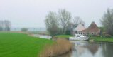
 Where
land and sea merge, Freiston in Lincolnshire Where
land and sea merge, Freiston in Lincolnshire
Courtesy: WESG/Jon Watson
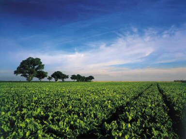
The reclaimed
land provides for rich agricultural and horticultural production
Courtesy: WESG/Fens Tourism
Reclaimed
land: land that was gradually reclaimed from the marine and fluvial
environments including reclaimed fen, marsh and estuaries. This is now characterised by being prime agricultural and
horticultural land with over 80% of the soils being classified as Grade 1,
the highest concentration in the UK. Crop coverage includes brassicas,
flower bulbs, beet, potatoes and other field and salad vegetables with some
cereals on the lower grade soils.
|
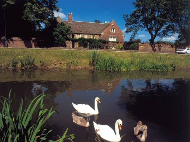
Townlands: the settlements of the hinterlands
generally follow an historic development pattern that represents higher
ground amongst the historic marshes. These historic towns and villages
were originally established as coastal or inland ports for trade in
salt, wool, wine and more through the ages.
Spalding,
an historic market town, sits on the banks of the River Welland
Courtesy: WESG/Fens Tourism |
 |
 |
Uplands:
situated only on the eastern shores of The Wash and dominated by large
estate ran arable and grassland farms with some remnant forestry. Further
inland and then cropping out at the east coast at the very mouth of The Wash
is the red and white striped sandstone cliffs eventually giving way to a
sand dune system.
The cliff line
that cuts along the coast at Hunstanton and progresses southward
Courtesy: WESG/Borough Council of King's Lynn & West Norfolk
|
3. Historic character
The Wash and its
hinterlands tell the story of man’s development in the area and the constant
fight/change between land and sea. This cultural landscape is illustrated in
many ways from the small mounds often seen cropping up in the otherwise flat
landscape indicating an ancient saltern to scar left from prehistoric field
patterns that can be seen from the air today. The following will provide a
brief tour.
Prehistoric
- Saxon
The heritage reflects the
diversity of the natural environment. In the lowland areas substantial
episodes of fresh and salt water flooding has largely buried earlier
prehistoric remains beneath clay, peat and silt. Occasionally remains of
mesolithic to bronze age date occur on islands within the fenland but such
episodes are increasingly rare towards the coast. Towards the end of the
Iron Age there was an expansion eastward and numerous salt-making sites of
transitional Roman date
appear, particularly around Spalding. Early and middle Saxon sites occur
within the transect with artefact scattered throughout and cropmarks in the
fields illustrating the sites today.
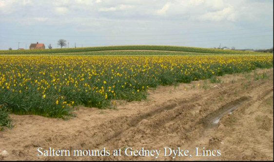
One of the many
mounds that depict an historic salt-making site
Courtesy: WESG/LCC
Medieval
Now the
heritage begins to become more visible; earthwork remains of castles and
manorial sites are frequent within the coastal parishes, some surviving as
earthworks in the fens. From this period and possibly as early as the 8th
century flood banks herald the reclamation of fen and marsh alike.
Salt-making develops once more as a major industry along the numerous havens
and coastal areas, subsequent sea embankments (dykes) fossilising the
resultant undulating landscapes. The villages are renowned for their
medieval churches. Spalding is the major town within the western section of
the transect which historically developed as a major local port and trading
centre from its late Saxon origins and, although it was not as important as
the international trading centres such as Boston and Kings Lynn, it can
boast some excellent medieval buildings, often hidden behind later facades,
and an excellent archaeological legacy. As with many major ports it suffered
decline at the end of the medieval period but a resurgence associated with
the large scale drainage of the fenland and the development of the
agricultural landscape lead to further development resulting in excellent
streetscapes of Georgian and later town houses and warehouses lining the
river which can still be seen today. King’s Lynn, in the eastern section of
the transect, remains an active port today but historically it was highly
important for trading with Europe and many fine examples of buildings from
the Hanseatic League days still remain.
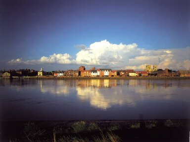
The historic
waterfront of King's Lynn
Courtesy: WESG/Fens Tourism
Later times
and built heritage
The area
contains some of the earliest brick buildings in the country, notably the
Boston Guildhall although outside of the transect. King’s Lynn still has
evidence in the form of old brick pits of its importance in the early brick
making days. But most of the surviving stock is of the 18th and 19th
century relating to agricultural expansion made possible by the new
reclamations resulting in grand farmhouses and associated farm buildings
being common. Changes in agricultural practices over the years have meant
that many buildings are now redundant and falling into disrepair, but they
are a most important element of The Wash landscapes.
Windmills are particularly prominent, although in various states of
disrepair, as are nonconformist chapels. The Wash was an important area in
the development of the non-conformist movements and there are a host of
chapels of various ages and states of repair.
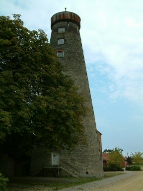
Moulton Mill
has the tallest mil tower in the UK. This image is before it was recently
restored which was overseen by the local community
Courtesy: WESG/Fens Tourism
The
industrial revolution, while hardly touching these largely rural and
agriculturally based communities did leave a rich heritage of railway
buildings and structures. Naturally the area also has a considerable network
of drainage and flood defence features, some originating from the monastic
drainage schemes of the medieval period but most dating from the 17th
century onwards. They form an intrinsic part of the landscape and differ in
character between landscape zones, being much more organic in the siltlands
and marshes than in the fens. These are associated with pumping stations and
other infrastructure, some of which enjoy legal protection today. The Wash
coast was also seen as of strategic importance in the preparations against
invasion during the World War II and the coastal areas are littered with
remains of pill boxes, prisoner of war camps and resistance hideouts.
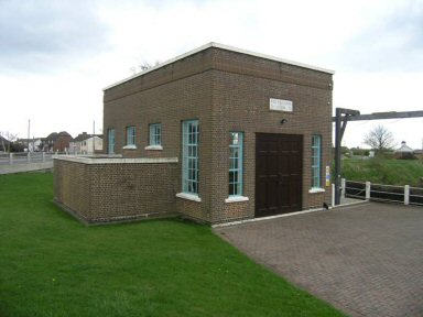
Pumping Station
at Pode Hole
Courtesy: WESG/LCC
Maritime
Heritage
The maritime
heritage consists not only of wrecks of all ages from the medieval period
through to planes from the World Wars, but also of the buried prehistoric
landscapes, which are occasionally exposed as in the example of Holme timber
circle, and the saltmaking sites along the Lindsey Marsh, although both are
outside the transect.
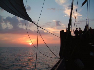
Maritime
history being brought back to life in The Wash in 2004: visiting Kieler
Hansakogge
Courtesy: WESG/Cameron Wilson
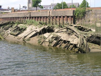
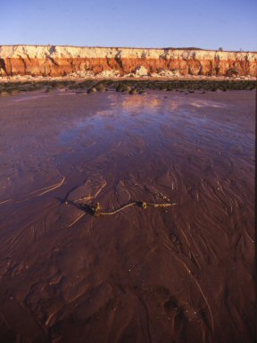
Wrecks are
found throughout including in the rivers, such as this
in the River
Witham ocally known as the Haven, just outside of the transect
Courtesy: WESG/Jon Watson
4.
SWOT
analysis
Strengths
-
Diversity of
the cultural and built heritage
-
Abundance of
still existing cultural and built heritage
-
Relative
uniqueness within the United Kingdom
-
Protection of
designated sites, such as Scheduled Ancient Monuments
-
Planning
policies to protect villages and landscape character associated with
Conservations Areas and Areas of Outstanding Natural Beauty
-
Often tranquil
setting
Weaknesses
-
Mostly the
wider landscape context of a designated site is not recognised e.g.
boundary is to focused without buffer zones
-
Legislation
allows for various class consents on designated sites which can have a
damaging effect, such as ploughing
-
Lack of
political will and corporate responsibility
-
Lack of
information and/or integrated information systems
Opportunities
-
Co-ordinated
data collection via further aerial mapping and further development of
Historic Environment Record Centres
-
Historic
Landscape Characterisation and Extensive Urban Surveys to be used to help
produce supplementary planning guidance and guide stewardship schemes =
spatial planning
-
Use of
stewardship schemes, such as the new agri-environment scheme Entry and
Higher Level Scheme
-
Government’s
historic environment review provides opportunities to close legislative
loop holes. The development of a Marine Bill and national Integrated
Coastal Zone Management Strategy will also improve management and
protection of our heritage.
-
To recognise
our heritage beyond that of just a structure but as part of the landscape
via influencing the above opportunities
-
Growing
interest in the public to manage and maintain our cultural and historic
heritage
-
Interpretation, raising awareness and restoration projects to encourage
local community to take ownership and increase local pride. Preferably
bottom-up approach.
-
To use
cultural and historic heritage as a catalyst for sustainable economic
regeneration and diversification, as is being achieved at Moulton Mill.
Threats
-
Climate change
and predicted sea level rise and increased storminess
-
While cultural
and built heritage is relatively abundant, it is under immense pressure
from redevelopment or neglect, as follows:
-
Drainage,
water transfer schemes and desiccation
-
Pond creation
for winter storage reservoirs and fishing lakes
-
Agricultural
and horticultural practices e.g. ploughing and glasshouse expansion
-
Absentee
owners so enforcement to safeguard building can not be served
-
Flood Risk
Management schemes beyond those of basic drainage
-
Increased,
non-sustainable leisure and tourism activities/developments
-
Piecemeal
development and urban creep
-
Infrastructure
improvements including to roads, ports, marinas, navigational waterways
-
Energy
production via traditional methods or renewable energy technologies
-
Development
of new nature reserves and nature conservation management techniques
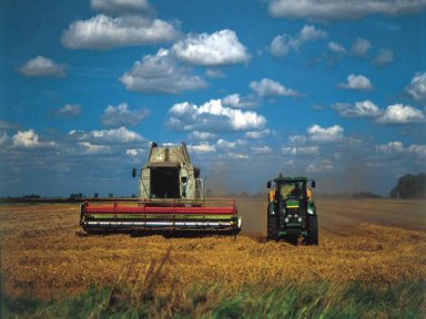
Farming
practices can damage our archaeological interests, but through agri-
environment schemes this issue could be tackled
Courtesy: WESG/Fens Tourism
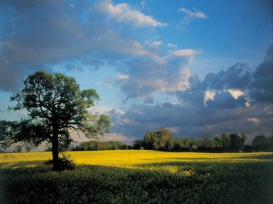
The rich
reclaimed land supports a busy bulb industry
Courtesy: WESG/Fens Tourism
5. Conclusion
The trend is one
with a positive outlook for cultural and historic heritage within The Wash
through to regional and national level. The Wash Estuary Strategy Group
recently completed a wide ranging review process consulting extensively with
the stakeholders to develop an integrated management plan for the area which
has a whole series of policies to help protect and enhance the cultural
landscape and historic environment assets of the area. At a regional level
the two spatial planning strategies recognised to some degree the wealth of
historic environment assets we have and nationally there are various
reviews, bills and strategies being developed to amalgamate and integrate
the laws and designation procedure protecting our built heritage and the
wider cultural landscape, which in hand with the changes to agri-environment
schemes will make a positive impact on the management of our ‘treasure.’
But more needs
to be done starting with improving our knowledge of what we have and
ensuring this is recorded in a usable and purposeful way. Continued work
with local communities is essential to achieve most of the policies set out
within The Wash plan, be that the various sectors that are present and
influencing their practices or inspiring a local group to take on the
management of their heritage. Also continued lobbying and responding to
relevant local to national government is essential to ensure that the
historic environment is taken into consideration in all planning aspects.
All of this requires stakeholder involvement and commitment and
co-ordination to ensure that everyone is going in the right direction, thus
a historic environment action plan developed in a collaborative way based on
sound knowledge of our stock is probably the best way forward. Hence,
working in partnership with the Lancewad Plan partners to develop such
practices.
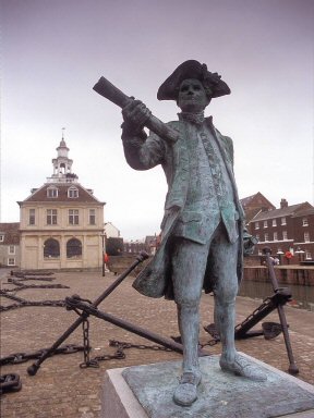 A
statue of just one of the great explorers from The Wash, Vancouver, found in
King's Lynn A
statue of just one of the great explorers from The Wash, Vancouver, found in
King's Lynn
Courtesy: WESG/Borough Council of King's Lynn & West Norfolk
|