|
1. Overview
|
Name: |
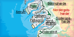
Nordergosharde |
|
Delimitation: |
The marshland area of the Nordergosharde is situated between the rivers of Soholmer Au in the North and Arlau in the south, running along the Geest of the Bedstedt bight in a narrow strip. Entities of Bökingharde in the north, Südergosharde in the south, Halligen in the west |
|
Size: |
Coast parallel strip of marsh land, ca. 13 km wide at its widest and about 4 km at its narrowest part, about 16 km long, ca. 13km from south to north, ca. 16 km from east to west |
|
Location
- map: |
Marsh land area west and north-west of Bredstedt, North Frisia, Schleswig-Holstein, Germany |
|
Origin of name: |
The name originates in the traditional appellation for the smallest Danish administration units. |
|
Relationship/similarities with other cultural entities: |
Former slat marsh islands with dwelling mounds and fieldscape like Hallig islands and Bökingharde, early modern dikes, modern, geometric polder like Bökingharde, Nordergosharde, Süderdithmarschen, nature reserve polder like Wiedingharde, Südergosharde, Nordstrand, Dithmarschen, farm buildings like other entities of North Frisia |
|
Characteristic elements and
ensembles: |
Detached farm mounds and village mounds with surrounding fieldscape and ring dikes, church with detached belfry, large Uthlande style farmhouses of that time, ponds and other water bodies and vestiges from dike breeches, characteristically designed farmsteads of Sönke-Nissen-Koog |

2. Geology and geography
2.1 General
The marshland area has developed by repeated erosion of Ice Age moraines and sandar in the area and subsequent sedimentation by the advancing sea during the Holocene, since the end of the last Ice Age. This has created bog and marsh areas, repeatedly flooded and intersected by tidal inlets. Most of it was lost in the time of increasing influence of the open sea during the late Middle Ages. The old marshes eroded, tidal inlets formed and the land was eventually submerged and washed away during devastating floods, notably the one in 1362. What was left were pieces of elevated salt marshes, Hallig islands, frequently inundated and dispersed across the mud flats of the north-western Nordergosharde area, and a very narrow strip of marshland just in front of the higher grounds of the Geest of Bredstedt.
2.2 Present landscape
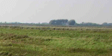
The Nordergosharde consist of low marshland hardly above high tide level. The northern part of the entity bears older remains of marshland as well as low, wet land along the rivers, while the southern part is narrower in its east-west extension and of newly embanked, high and fertile marshland. It is among the latest and least extensive in the whole of the Wadden Sea coast of Schleswig-Holstein. Hamlets and detached farmsteads in the in the north-west are located on dwelling mounds, surrounded by roads and dikes, which indicate the former shape of the Hallig islands. Fields are small and irregular enclosures, arranged around the mound villages or along former tidal inlets. Polders in the rest of the area are spacious with rectilinear and large-scale fields and detached farms on low mounds along a central, perpendicular network of roads, whereas the field system in the north-eastern and eastern marshes consists of patches of rectilinear, co-axial fields, oriented towards the linear village of Langenhorn or towards the rim of the Geest. Trees are only planted around farms and within villages as windbreak. Tall constructions are numerous wind power generators in the modern polders of Reußenköge. The marshland in the north is used for grazing and farming, while in the south farming dominates the land use. Houses are usually one to two storeys high and often built in traditional style or are large, detached farmsteads in the modern polders.
3. Landscape and settlement history
3.1 Prehistoric and Medieval Times
Earliest settlement, as usual, took place on the Geest already in the Young Stone Age, while the still existing villages along the edge of the high ground were foundations of the Middle Ages. During this early time most of the forest on the Geest was already cut and agriculture led to soil depletion and the development of widespread heathland areas. The extension of settlement in the old salt marshes during early and high medieval times is unknown as this landscape was destroyed by storm surges especially in the 14th century. After the destruction of the old marshland in front of the coast in 1362, the Wadden Sea almost reached up to the villages on the edge of the Geest, which, just behind the village of
Breklum, heightens up to 44m. The narrow belt of old marshland, that remained, was used again by the villages for extensive grazing., this old marshland area, which has never been occupied by farms, and the low marshes, which reached more inland along the banks of the Soholmer and Lecker Au, was embanked by the three adjacent villages of
Bordelum, Breklum and
Bredstedt and by Langenhorn in the 15th century.
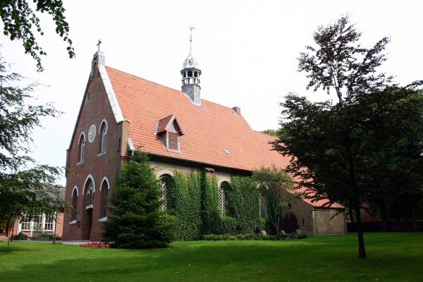 |
| The church of Bredstedt.
© ALSH |
The area of the
Langenhorner Alter Koog
could only be poorly drained and used to be inundated for longer periods of
the year. The site of an old farm, protected by low ramparts, at Wester-Bordelum, is a remnant of medieval settlement at the very verge of the Geest which was called “Fru Mettjens Hof”, after which the later
Frau-Metten-Koog was
named.
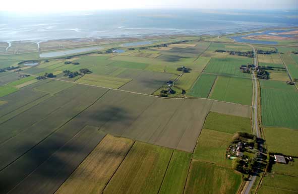 |
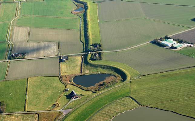
| Medieval, former Hallig
mounds on Ockholm and ponds of dike breeches in the background.
© ALSH |
The marshland around the dwelling mounds of Ockholm kept its appearance as Hallig island till it was eventually reclaimed and connected to the mainland in 1515. The old mounds, which are unique in the Nordergosharde, still exist, as do parts of the old sea dikes and most of the medieval, irregular and small fields, which were solely used for grazing at the time. The
Baroque brick-church was built as simple as all churches on Hallig islands with a detached bell frame. It was allegedly the third that had to be built after the catastrophes of 1362 and 1634, of which also large ponds, as result of
dike breeches, tell along the southern
dike.
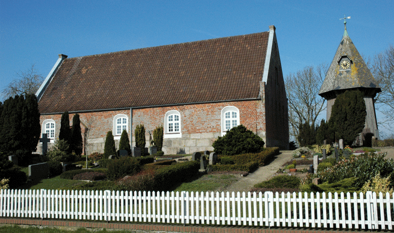
Simple Baroque brick-church in Ockholm with a detached bell
frame. © M.
Vollmer
3.2 Early Modern Times
The closing of the dike line between the polders at Bredstedt and the Langenhorner Alter Koog in the north in the 16th century was made impossible for a long time due to frequent severe storm floods and could only be achieved in the late 17th century. The shifting of the dike line further west, which was supposed to dam a large tidal inlet threatening the old embankments, was ventured gradually in the 18th century. The first polders were imposed by the Danish king and financed by rich private investors, who in return gained many privileges concerning the use of the new land and tax relief for a certain time. Also, these new polders were only reclaimed after marshland had accumulated considerably in height, resulting in extremely fertile soil. The new land was protected by dikes designed according to modern knowledge from the Netherlands with very moderate slopes.
 |
a.jpg) |
|
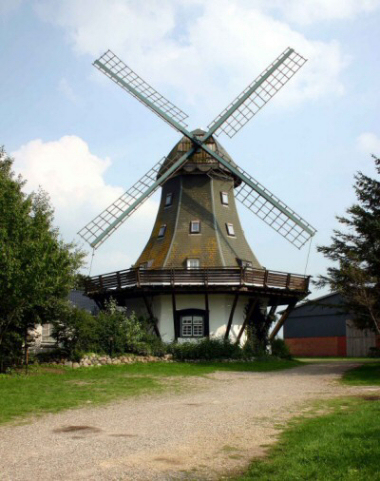
Dutch type windmill in Langenhorn on the Geest.
© ALSH |
Mediaval
Polder in front of the more elevated Geest.
© ALSH |
The fertile marshes were usually sold to ingenious farmers. But even here important differences could be observed, when the people in the
Luisen-Reußen-Koog suffered from bad harvests and were compelled to sell their land, while farmers in the
Sophien-Magdalenen-Koog and
Desmerciereskoog switched from cultivation to ox breeding and then, in Modern Times, back to farming, following the markets and turning to the most profitable trend. Only few farmsteads were erected along central roads with large, rectangular adjacent fields. The farmsteads in the wealthier polders were usually large and representative and made of brick with slated roofs, often surrounded by ditches, like the impressive
Müllerhaus in the Desmerciereskoog, a farm of the Geesthardenhaus type from the late 18th century but with a thatched roof.
a.jpg) |
|
Modern polder of Desmerciereskoog from the late 18th
century.
© ALSH |
One farmstead in Luise-Reußen-Koog was more oriented towards the traditional Uthlande style houses, also brick built, but supported by an internal timber structure. Farmsteads in the
Reußenkoog were especially scarce as the relatively small-scale fields were cultivated from farmers on the Geest. The Bredstedter Werk, the reclamation of the Bredstedt Bight, started with the Sophien-Magdalenen-Koog in 1741 and was successfully finished in 1799 with the
Luisen-Reußen-Koog.
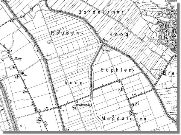 |
| Map of Reußenkoog.
©
VermA-SH |
The joint between the modern, smoothly sloped and the medieval, more vertical dike in the southern part of the Desmerciereskoog allegedly inspired the famous local writer Theodor Storm to his novel about dike construction and storm flood “Der Schimmelreiter”. Consolidation of farming in the end of the 18th century divided the common marsh land along the edge of the Geest into long and narrow strips of fields, perpendicularly oriented towards the Geest.
3.3 Modern Times
The drainage situation in the low northern polders south of the Soholmer Au improved when the
canal of Bongsiel was built in the 19th century provided Ockholm the still extant harbour of Bongsiel, used for trade and fishery till 1959, when the canal was led through the new Hauke-Haien-Koog further north.
a.jpg) |
 |
|
The
canal of Bongsiel improved the drainage situation in the 19th century.
© ALSH |
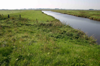
Soholmer Au.
© ALSH |
Remains of the old course of the Soholmer Au can still be traced as meandering ditches in the Neuer-Störtewerker-Koog. A dam connected the tiny Hallig-island of Hamburger Hallig from 1826 on, after a first attempt was destroyed in the disastrous flood of 1825. The now quickly accumulating marshland along the dam fostered the construction of the first new polder after more than a hundred years. The heathland on the Geest was only cultivated again in the late 19th and in the 20th century by usage of fertilising marl from Pleistocene origin in the area, like pits near Dörpum, used for marl extraction, indicate. Also new forest has been planted from this time on. The salt marshes in front of the sea walls were used for grazing cattle, which were supplied by fresh water from embanked pools, like an example in the Cecilienkoog, in order to protect them from the sea water. In 1905, now initiated mainly by the government of the then recently constituted Schleswig-Holstein, the
Cecilienkoog was embanked north of the polders of Hattstetter Marsch and the land was bought soon by farmers from Dithmarschen in the
south.
In the early 1920ies Sönke
Nissen, an inhabitant of the region who made his fortune with diamonds in Africa, invested parts of it into a new, large polder, which had not only the systematical structure of the other polders, but also received an encompassing architectural conception for all of its farmsteads. These are unique for their open concept of arrangement while still retaining a distinctive style of traditional elements and modern aspects, like green tin roofs, derived from south-west African, colonial style.. The land use has switched in the course of time from animal breeding to
agriculture.
|
 |
|
Fieldscape of medieval, former Hallig island of Ockholm (left) and
Sönke-Nissen-Koog of 20th century origin (right).
© ALSH |
The largest changes for centuries were again brought about by the Programm Nord, in order to strengthen the agrarian subsistence and improve the quality of rural life, infrastructure and drainage situation as well as the coastal protection. New roads were constructed where accessibility had always been a problem and agriculture became eventually possible in the low lying, wet marsh areas around the Soholmer Au due to improved draining of the inland water. Despite the impacts of the program, in the Ockholmer Koog the old, irregular block structure of the early fields around the former Hallig-mounds is still visible, as are the course of ancient, meandering tidal inlets. Only two new and small development areas have been added at Süderdeichsweg and few farmsteads have moved to more spacious areas in the east of the polder or to the new polder of Hauke-Haien-Koog. The town of
Bredstedt on the Geest has developed into a regional centre and started to sprawl into the marshland with a large new development area west of the historical centre. The very controversial polder of
Beltringharder Koog tightened the already existing connection between the island of Nordstrand and the mainland in the 1980ies. The enormous area serves, besides coastal protection as its main purpose, solely as water reservoir and nature sanctuary.
Wind power generators in almost any of the polders of Nordergosharde have established a new impression of the flat and almost treeless landscape since the 1990ies and led to an additional means of income for the local farmers, which reflect an impressively wide variety of land use, from organic farming to
4. Modern development and planning
4.1 Land use
Agriculture is mostly based on intensive cultivation and stock breeding in the Reußenköge and the eastern part of Hauke-Haien-Koog, while the northern marshland of Nordergosharde is predominantly used for grazing, due to its inferior soil quality. Many farms have added modern farm buildings to their historic farmsteads. The western part of Hauke-Haien-Koog and Beltringharder Koog are a nature sanctuaries and reservoirs for the inland water. The salt marshes in front of the outer sea walls with the island of Hamburger Hallig belong to the Wadden Sea National Park. Smaller nature protection areas are in Bredtstedter Koog and along the Soholmer Au.
4.2 Settlement development
Settlement consists mostly of single farmsteads in the south and single farms and hamlets on mounds in the north. The town of Bredstedt on the Geest outside the area of the entity has developed into a regional centre and sprawled into the marshland with a large residential area west of the historical centre. The edge of the Geest is now regarded as limit for further development. Only two small residential areas have been added at Süderdeichsweg in Ockholmer Koog and few farmsteads have moved to more spacious areas in the east of the polder or to the new polder of Hauke-Haien-Koog. The whole of the entity of Bökingharde is rated as tourist and recreational area. Centring on the nature experience area of Stollberg north of Bredstedt, a variety of cycling tracks with information on cultural landscape and nature have been implemented throughout the entity.
4.3 Industry and energy
Wind turbines are concentrated to the early modern and modern polders of Reußenköge. The northern marshes south of the Soholmer Au are free of such systems. Most of the turbines of the first generation have now been substituted by larger 2 MW systems. Solar panels have been introduced in the Reußenköge as well. Many farms are fitted with panels on their roofs, which has caused a conflict with monument protection at Sönke-Nissen-Koog. A solar panel field was implemented recently.
4.4 Infrastructure
Roads are mostly based on historic routes and connections between settlements and are sometimes built on top of former sea walls in the north. The modern harbour of Schlüttsiel in Hauke-Haien-Koog is the main connection to the Hallig islands. A private road connects the Hamburger Hallig to the mainland. The Hallig island of Nordstrandischmoor is connected via a narrow gauge railway to Cecilienkoog.
5. Legal and Spatial Planning Aspects
The area of the Hauke-Haien-Koog, Langenhorner and Störtewerker-Koog, as well as the marshes around the river Soholmer Au are recognised by spatial planning as especially characteristic landscapes. The vicinity of Ockholm, Fahretoft and Langenhorn holds the prerequisites for a nature protection area, whereas the polder of Beltringharder Koog is an international nature sanctuary according to RAMSAR. Agricultural production is especially diversified. The Hauke-Haien-Koog and marshes around Ockholm fulfil requirements for nature protection areas. The marshes around Fahretoft, Langenhorn and Ockholm are suitable for landscape protection. However, no new protection areas are planned to be implemented in North Frisia. Nature protection rather aims at further integrating agriculture and promoting extensive stock breeding and contract based nature protection, as it is done in the Hauke-Haien-Koog. Furthermore, it is suggested to raise the number of so-called typical landscape elements and to integrate existing elements into the network of biotopes and protection areas. The landscape plan supports the integration of historic settlement structures into planning. The tourism concept for North Frisia promotes a sustainable development in this sector. An improvement of landscape related tourism together with riding, cycling and hiking is suggested by landscape planning. The information centre of Amsinck-Haus gives insight into the landscape development and nature.
6. Vulnerabilities
Many of the old buildings dated back to the embankment of the older polders were substituted by modern structures. Economical pressure could further lead to alteration and destruction of historic landscape structures and values, especially in the agrarian sector. More wind power generators strengthen the economic situation of local farmers on the one hand but influence the historic landscape aspects strongly on the other. Conflicts with monument or nature protection, like in Sönke-Nissen-Koog, could have been avoided or mitigated previously with the implementation of local landscape and cultural heritage models or strategies.
7. Potentials
The historic settlement and field structure in the planned polders in the
south and in Ockholmer Koog is generally intact and has been altered
comparatively little by measures concerning consolidation of farming. Only
few residential areas have been added to existing settlement areas.
Agriculture could further focus on farming and animal breeding methods,
which support still intact, typical field systems. Landscape values are well
communicated to tourists and inhabitants by signposted routes and the
information centre of Amsinck-Haus. As single site, the old harbour of
Bongsiel could be revitalised and used for tourist and recreational
purposes.
8. Sources
Author: Matthias Maluck
General literature:
Vollmer, et. al. (eds.) 2001. Landscape and Cultural Heritage in the Wadden Sea Region – Project Report. Wadden Sea Ecosystem No. 12. Common Wadden Sea Secretariat. Wilhelmshaven, Germany.
Innenministerium des Landes Schleswig-Holstein (eds.) 2004. Regionalplan für den Planungsraum V, Amendment File.
Ministerium für Umwelt, Natur und Forsten des Landes Schleswig-Holstein (eds.). Landschaftsrahmenplan für den Planungsraum V. Kiel 2002.
Kunz, H. & Panten, A. 1997. Die Köge Nordfrieslands. Bredstedt.
Bantelmann, Landschaft und Besiedlung Nordfrieslands in vorgeschichtlicher Zeit (Husum 1992)
Bantelmann, A. (ed.) 2000. Das große Nordfrieslandbuch. Bredstedt.
Gemeinsames Wattenmeer Sekretariat (ed.) 2005. Das Wattenmeer. Theiss Verlag Stuttgart.
Beseler, Kunst-Topographie Schleswig-Holstein (Neumünster 1969)
Braun, Strehl (eds.), Langhaus und Winkelbau. Uthlandfriesische Bauformen im 18. und 19. Jahrhundert (Bredstedt 1989)
Vogel, Der nordfriesische Geestrand, die Entwicklung seiner ländlichen Siedlungen und ihrer Flurformen (Bräist/Bredstedt 1996)
Fahrenkrug et. al. Regionales Entwicklungskonzept Nordfriesland (unpublished, 2003)
Maps:
Archaeological monument record of Schleswig-Holstein and gis mapping
Lancewad data base and gis maps
Royal Prussian ordnance survey of 1879
Map of H. du Plat of 1804/05
Comment:
The area, especially the Reußenköge, provide good example of local involvement in heritage issues. However, conflicts like the solar panels on roofs of historic buildings indicate, that there is a strong need for discussion and of a model or strategy for the future. The area is also less harmed by modern changes as wind power has been implemented early on a large scale and agriculture is still rather profitable. These developments have had only minor impact on the landscape with its early modern structures. More small-scale landscapes like the north of the entity around Ockholm or Hattstedtermarsch in the south cannot copy this development without harming their historical landscape structures severely. Individual solutions and also co-operation between these areas are therefore mandatory. Thus, tourism could focus more on the older marshland areas whereas people from these parts need the opportunity to make investments like wind turbines elsewhere.
|